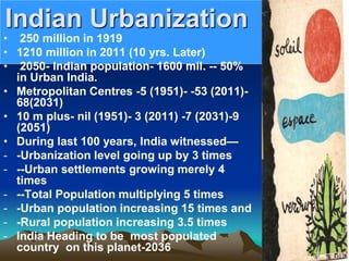
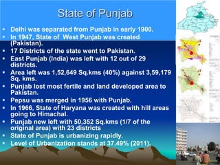
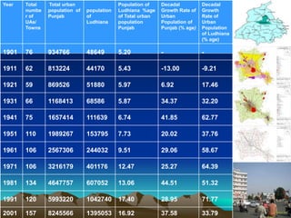
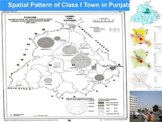
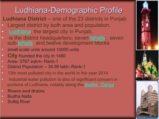
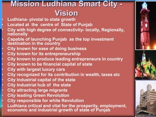
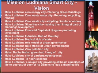
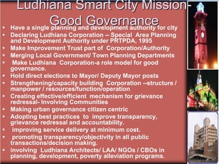
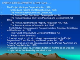
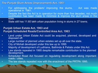
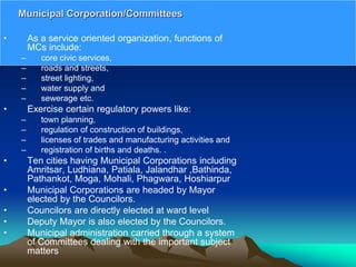
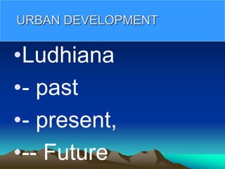
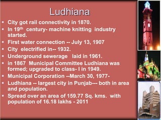
The document discusses plans to make Ludhiana, India a smart city. Key points:
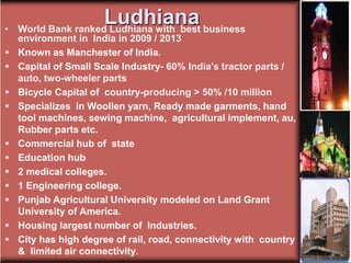
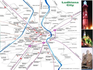
- Ludhiana is a major urban center in Punjab experiencing rapid population growth and urbanization.
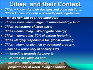
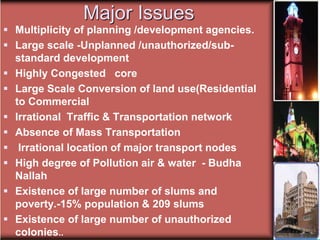
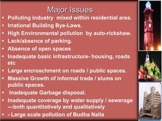
- It faces issues like unplanned development, congestion, pollution, and lack of infrastructure.
- The vision is to make Ludhiana a zero-energy, zero-waste, pollution-free, green, and slum-free city with good governance and improved mobility.
- This will be achieved by replanning the city, improving governance, leveraging new financing models, and following good urban development practices.
Ppt on Bhilai talking about its location, social image, SWOT analysis, population density trend and growth of town.
Hope it helps,
Do write your suggestions
The document summarizes a master plan for a new township development near Indore, India with the following key points:
- The plan was developed for a 220 acre site intended to house an initial population of 40,000 people. The master plan divided the site into sectors with a central commercial and institutional spine and mixed land uses.
- Housing was provided for a range of income groups, with lower income housing located centrally and higher income housing along perimeter roads. Basic infrastructure like roads, water, sewage was provided to each housing plot.
- The envisioned built form took cues from traditional local architecture, with low-rise, high density development and continuity of built edges to encourage community interaction while providing privacy
Gandhinagar,Gujarat,India- Urban Design for Student Architects.Vimita Prasanna
Gandhinagar is the capital of Gujarat, India, located along the banks of the Sabarmati River. It was planned in the 1960s as the new capital after Gujarat split from Bombay state. The city was designed by Indian planners in a highly structured grid layout divided into 30 sectors. Gandhinagar remains one of the greenest and most planned cities in India due to its new development and emphasis on green spaces throughout the urban planning.
The Aranya Community Housing project in Indore, India aimed to provide affordable housing for lower income groups through a planned, serviced site development approach. The 85 hectare site was divided into 6 sectors serving different income levels. The master plan emphasized a hierarchy of roads, open spaces, and mixed land uses to create integrated neighborhoods. Housing typologies allowed for incremental expansion over time. Core housing units provided basic facilities with flexibility for residents to customize indoor and outdoor spaces. Materials and construction methods were locally sourced and labor intensive to keep costs low.
The document provides information about Delhi, India. It discusses Delhi's history, population, languages, area and literacy rate. It then summarizes Delhi's growth as a multicultural metropolis and center of culture, politics and commerce. It highlights some of Delhi's famous historical and religious monuments and discusses the city's festivals, markets, cuisines and transportation system including the Delhi Metro. The document also notes Delhi's role as India's political hub and its hosting of the 2010 Commonwealth Games, while also mentioning some associated concerns and controversies.
The document provides a history of the city of Ahmedabad from its founding in the 13th century to present day. It began as a city called Karnavati on the banks of the Sabarmati River under Solanki dynasty rule. In the 14th-15th century under Sultanate rule, it was renamed Ahmedabad and established as the capital of Gujarat. The city grew as an important trade, textile and cultural center under Mughal rule in the 16th-17th century. After a period of decline in the 18th century under Maratha rule, the city saw rapid growth under British rule in the 19th century as an important trade center connected by new railways. After independence
Nanded City - a 700 acre mega township is the first of it’s kind planned, integrated, self-contained development in the country which is designed in tune with nature. It is a re-enactment of the ‘Inclusive Model’ of Magarpatta City which has been based on the participation of original farmer – land owners.
The document summarizes the development of the city structure of Bhubaneswar, India over time. It describes how the city began as a temple town (until 1948) and was then established as the new capital of Orissa in 1948, with a master plan developed by Otto Koenigsberger. It outlines the stages of the city's growth, including the establishment of institutions from 1956-1976, organized sector developments from 1976 onward, and the current extent and layout of the city. Land use is also summarized, including the original 1968 master plan and subsequent 1988-2001 comprehensive development plan.
Millennium Indraprastha Park is one of the longest parks in Delhi covering 34 hectares. It was created on a former sanitary landfill site and transformed into a lush green space with various gardens and plantations. The park contains five main gardens - Smriti Van, Fragrant Garden, Foliage Garden, Bougainville Garden, and Topiary Garden - each showcasing different themes, plants, and design elements. It provides a tranquil escape for Delhi residents and tourists amidst the urban environment.
A slum is a condition which is unfit for human habitation. Therefore, this pdf talks about one of the densely populated slums of Delhi and its characteristics.
Chokhi Dhani is an 18-acre ethnic village resort located near Jaipur, Rajasthan. It was designed to resemble a typical rural Rajasthani village, with mud and thatch huts, temples, shops, and entertainment spaces laid out in a radial pattern around a central restaurant and banquet hall. The resort includes over 30 huts, 8 luxury suites, and conference/dining facilities. Local materials like stone, mud, bamboo, and terracotta tiles were used, and the village atmosphere is enhanced with traditional performances, shops, rides, and landscaping. The goal was to preserve rural Rajasthani culture while providing modern amenities.
This document provides a site plan for housing for mahouts (elephant keepers) and their families in Hath Gaon, Jaipur. The plan centers around a large central court that will integrate services and act as a community space. It includes mahout units surrounding the central court, as well as pathways, reservoirs, and viewing areas for elephants, and a hospital and other services for residents. The entrance plaza is planted densely as an interface to the habitat.
Evolution of Chennai & Bangalore over timeAbby Varghese
This document summarizes the evolution of Chennai and Bangalore over time. It describes how Chennai began as a small fishing village known as Madraspatnam that gradually grew around Fort St. George, established by the British East India Company in 1639. Similarly, Bangalore emerged from a mud fort established in 1537 and changed hands between various ruling powers before the British shifted their cantonment outside the old city in 1809, giving rise to a new town. Both cities have since transformed into major economic, cultural, and educational centers in South India.
presentation tries to focus on housing, its role and importance for communities and also how it can be made cost- effective in the background of Pradhan Mantri Awas Yojna
This document provides information about the cold desert climate and geography of Ladakh, India. It discusses the climate characteristics of cold deserts including very hot summers and bitterly cold winters with low precipitation. It then describes specific climate data for Ladakh including average temperatures and precipitation levels. The document also outlines the effects of global warming on cold deserts such as declining rainfall in some areas and increasing rainfall in others.
Indore (Listeni/ɪnˈdɔər/, Hindi: इंदौर; Marathi: इंदूर) is a tier 2 city, the largest city of the Indian state of Madhya Pradesh by population.[4] It serves as the headquarters of both Indore District and Indore Division. A central power city, Indore exerts a significant impact upon commerce, finance, media, art, fashion, research, technology, education, and entertainment and has been described as the commercial capital of the state.
Located on the southern edge of Malwa Plateau, the city is located 190 km west of the state capital of Bhopal. With a Census-estimated 2011 population of 3,276,697[5] distributed over a land area of just (3,898 square kilometer), Indore is the densely populated major city in the central province. The Indore Metropolitan Area's population is the state's largest, with 3.2 million people living there. It is the 9th largest city in India and 76th[6] largest city in the world.
Indore traces its roots to its 16th century founding as a trading hub between the Deccan and Delhi. The city and its surroundings came under Maratha Empire on 18 May 1724 after Maratha Peshwa assumed the full control of Malwa. During the days of the British Raj, Indore State was a 19 Gun Salute (21 locally) princely state (a rare high rank) ruled by the Maratha Holkar dynasty, until they acceded to the Union of India.[7] Indore served as the capital of the Madhya Bharat from 1950 until 1956.
Indore's financial district, anchored by central Indore, functions as the financial capital of the Madhya Pradesh and is home to the Madhya Pradesh Stock Exchange, India's third oldest stock exchange. Indore's real estate market is among the most expensive in the Central India.
History
Origins[edit]
Indore owes its early growth to trade and commerce, which is still a dominant feature of the city. It is the commercial capital of the central Indian state of Madhya Pradesh. The present city is about 500 years old. Till the end of 15th century, its original nucleus was a river side village which occupied the bank of river Saraswati. This area is now known as Juni Indore.
The area of the modern Indore city was a part of the Kampel pargana (administrative unit) during the Mughal Empire.[8] Kampel was administered by the Ujjain sarkar (government) of Malwa Subah (province). The area was controlled by the local zamindars (feudal landlords), who accepted the suzerainty of the Mughal empire. The zamindars received the title of Chaudhari, which established their claim to the land.
The modern settlement was developed by Rao Nandlal Chaudhary, the chief local Zamindar, who had an army of 2000 soldiers. Under the Mughal rule, his family enjoyed great influence and was accorded confirmatory sanads by the Emperors Aurangzeb and Farrukhsiyar, confirming their jagir (land ownership) rights.
Climate
Indore has a borderline humid subtropical climate (Köppen climate classification Cwa) and tropical savanna climate (Aw). Three dist
Development control regulations kochi reportGeeva Chandana
The document summarizes the development control regulations for the Kochi City Region in Kerala, India. It provides an overview of the planning area and divisions, estimated future land requirements, development concepts and strategies, land use categories and regulations, and transport proposals. Key points include that the planning area covers Kochi city and surrounding areas, there is a need for more recreational, commercial, and transportation lands, and the goal is to develop Kochi as a global city with diversified industries and improved regional transport links.
Majuli is the largest river island in the Brahmaputra River in India. It has faced significant land erosion and threats to its cultural heritage from floods and urbanization. The island has a unique culture centered around Vaishnavism and satra monasteries. The government has undertaken measures to protect Majuli, including reclaiming land and raising awareness about conservation efforts to preserve the island's heritage.
The document discusses the town planning of Delhi, including its geography, history of urbanization, population growth trends, and master plans implemented over time to accommodate increasing population. It provides details on the planning and development of Shahjahanabad during Mughal rule in the 17th century, including the layout of key areas like the Red Fort, Jama Masjid mosque, streets, neighborhoods, gardens and city walls. It also briefly outlines the subsequent development of Lutyens' Delhi after Delhi became the capital under British rule in the early 20th century.
The document discusses the history of town planning in ancient India, beginning with the Indus Valley Civilization around 3000 BCE. It describes how the cities of Mohenjo-Daro and Harappa exhibited advanced systems of town planning, with organized layouts of streets, drainage, and buildings. Subsequent periods, including Vedic, Buddhist, medieval, Mughal, and British rule, all continued developing principles and practices of town planning across various cities and settlements in India.
The document summarizes Charles Correa's incremental housing project in CBD Belapur, India. It describes the project's low-cost housing typologies designed around communal courtyards. Housing was organized into clusters of 7-12 pairs of freestanding homes arranged around shared spaces. This allowed residents to independently modify their own homes over time. While many original structures have been replaced, the hierarchy of community spaces remains intact decades later. The project demonstrated high-density affordable housing built at a human scale with simple materials. However, maintaining common spaces and adapting to changing aspirations have presented challenges over time.
The document summarizes the traditional pol house architecture of Ahmedabad, Gujarat. [1] Pols are enclosed residential neighborhoods entered through gates, featuring narrow streets and shared community spaces. [2] They originated from rural khadki settlements for security, with homes adjoining and enclosing shared yards. [3] Pol houses are organized around central courtyards (chowks), with rooms along three walls and an entrance platform (oatla) on the fourth, providing light, ventilation, and climate control in Gujarat's hot, dry climate.
Connaught Place and India Gate are two iconic landmarks in Delhi designed by Sir Edwin Lutyens. Connaught Place is the central business district of Delhi, built in the 1930s as a circular complex housing shops and businesses. It features colonnaded walkways and was designed to blend European and Indian architectural styles. India Gate is a war memorial located near Rajpath, built in 1931 to commemorate Indian soldiers who died in World War I and other conflicts. It takes the form of a massive sandstone archway topped with sculptures and inscriptions.
Charles Correa is an Indian architect known for adapting modernism to non-Western cultures through an emphasis on local vernacular styles, resources, climate and open spaces like courtyards. Some of his notable works discussed include the Gandhi Smarak Sangrahalaya memorial in Ahmedabad using modular units, the high-rise Kanchanjunga Apartments in Mumbai with garden terraces, and low-cost housing projects in India and Peru organized around courtyards for ventilation.
This document discusses tribal housing in India. It begins by introducing India's tribal or Adivasi population and their distribution across the country. It then describes the local materials and customs used in tribal house construction. The document goes on to analyze tribal housing typologies in different geographic zones of India based on climate, available resources, and tribal group. It provides examples of house structures from various tribal communities. The construction techniques used include mud walls, thatched or tiled roofs, bamboo, wood, and adobe bricks. Housing patterns include cluster, linear, and scattered arrangements.
This presentation covers the Urban Planning stages of Bhubaneswar, one of India's first modern cities along with Jamshedpur and Chandigarh. This city, the current capital of the coastal state of Odisha, was planned the German architect and urban planner, Otto Konigsberger, who also happens to be the author of 'Manual of Tropical Housing and Building.'
Making Ludhiana Smart- Concepts, Issues and Options JIT KUMAR GUPTA
This document discusses plans to make Ludhiana, India a smart city by addressing several issues and providing solutions. Key points include:
- Ludhiana faces issues like unplanned development, pollution, lack of infrastructure and open spaces
- The vision is to make Ludhiana a zero-waste, green, and slum-free city that is a model for urban governance and development
- Solutions proposed include replanning the city on a regional scale, improving governance through a single planning authority, boosting finances, and prioritizing public transport and pedestrian access over personal vehicles.
Infrastructures and services are known to be the backbone of any human settlement . They are known to be determinant of the quality of life and operational efficiency of any city. They are also the one regulating the productivity of the city. Infra remain vital for all the urban residents , communities, city and the state. Accordingly, it becomes important that infrastructures on prescribed norms and standards are made available in both quantity and quality in the human habitation. Providing Infra requires lot of resources and technology know how. Accordingly adequate provision in the budget of urban local bodies need to be provided. in addition to providing infra and services, it is critical that they are also maintained properly. Key issues in the infra is the delivery of services. Government must involve private sector in providing services. Services charges also have to be rational to make them affordable. Providing services and infra remains a difficult and innovative option. It offers both a challenge and an opportunity. All ULBs must ensure adequate services of appropriate quality to all its citizens , even poorest of poor, to lead a dignified living.
Need for Convergence in Planning and Implementation Across all MISSIONSJIT KUMAR GUPTA
Presentation is a brief attempt to showcase the need and importance of convergence of planning and implementation of all the urban missions in order to achieve holistic development of the urban centres in India and to launch Urban India on fast trajectory of Urban revitalisation. It needs to be expanded further to make it more extensive and meaningful
Paper looks critically and objectively, the role and importance of Master Plans in Rationalising the development of cities, issues created and options to make it a better master plan
Poverty remans the greatest curse on humanity . Getting out of poverty would require empowering human beings through skilling and education, providing opportunities to explore options for employment, making available resources and holding hand for alleviating poverty. Presentation focus on how to leverage urban planning in empowering urbanites to overcome poverty.
Strategy and Options for Planning Inclusive CitiesJIT KUMAR GUPTA
Presentation looks at the context of inclusive cities, its relevance in the Indian context, problems faced by Indian cities and what are the options to make cities inclusive, and sustainable
This document discusses global and Indian population trends, urbanization rates, and issues related to urban infrastructure development. Some key points:
- World population has grown rapidly from 1 billion in 1804 to over 7 billion currently, and is projected to reach 8-11 billion by 2050. India surpassed China as the world's most populous country in 2023.
- India's population grew from 250 million in 1919 to over 1.2 billion in 2011. By 2050, 50% of India's population is projected to live in urban areas. Many cities are growing rapidly but face infrastructure challenges.
- Urban areas will be critical for India's economic growth but most cities face issues like lack of adequate housing
Presentatio tries to bring out context of the cities in the overall development of communities and nations, and the manner cities are being subjected to devlopmental and population pressure. As engines of economic growth cities are known to have environmental, ecological and infrastructure implications besides becoming the major propeller of global warming and climate change. Looking at the role and importance of cities in alleviating poverty, pollution and numerous other growing dualitues and contradictions, presentation focusses on how to make growth and development of cities more rational, sustaianble, inclusive, safe abd resilient.
Presentation makes an attempt to brief about the genesis, brief of preparing master plan for an urban settlement to rationalise the growth and development of any urban centre
This document discusses population growth trends worldwide and in India, with a focus on urbanization. Some key points:
1) The world population reached 7 billion in 2010 and is projected to reach 7.9-10.9 billion by 2050, with China and India each having over 1 billion people.
2) India's population reached 1 billion in 2000, 1.2 billion in 2011, and is projected to reach 1.8 billion by 2050, with 50% living in urban areas.
3) Urbanization is seen as both a driver and consequence of economic development. As urban areas generate wealth and tax revenue, their effective management is critical for India's continued growth.
4) By
This document discusses smart cities and urban planning in India. It begins with definitions of traditional city planning and smart city planning. It then discusses the impacts of globalization and economic changes on urbanization and city growth in India. Some key challenges discussed for Indian cities include population growth, urban sprawl, flooding, garbage, air and water pollution. The document examines trends in urbanization for India by 2030 and outlines some urban challenges around areas like transportation, infrastructure, land use, and the environment. It advocates for a shift towards more sustainable urban planning approaches focused on mobility and people rather than just transportation infrastructure expansion.
Cities and civilizations remain
synonymous. Cities remain unique, different and distinct. Cities existed in the past, they exist now and they shall continue to dominate the future of human journey on this planet earth. No two cities are same. Each city has its paces of strength and weaknesses. Making any city great, ,has genesis in understanding its uniqueness and making optimum use and build on its strength; overcoming the existing weaknesses; creating opportunities for its orderly growth and overcome possible challenges which may emerge in its march to become great. Cities must be owned by people and city must own its people. we need co-operative cities and not smart and sky scrapper cities. People would need cities which provides them safety and basic amenities of life, make them happy and healthy. City must create options for providing best possible living to its people; create options for appropriate working; make people happy and healthy; both physically and mentally and make them travel only when needed and that too on a limited scale. Following this order of planning can surely enhance the credibility and operational efficiency of the cities. Planning cities, using nature and natural elements of Sun, Space and Greenery can help in making cities wonderful and healthy places to live and work. Cities must identify, preserve, manage, protect and manage its Heritage, as integral part of its growth and development to make it connect with past glory. Agra needs to be made, promoted and declared as a heritage city to showcase its past glory and make it integral part of future growth and development. Ignoring and damaging its heritage, which lead to chaos and anarchy. Agra must come out with its own charter of growth and development to retain
not only its past glory but also charter an agenda of its glorious future growth.
This document discusses the rural-urban fringe and its stages of transformation. It begins by defining the rural-urban fringe as the zone between city and country where rural and urban land uses are intermixed. It then describes the structure of the fringe, which includes municipal towns and revenue villages. The document outlines five stages of a village's transformation as it comes under the city's influence: 1) the rural stage, 2) agricultural land use change, 3) occupational change, 4) urban land use growth, and 5) the urban village stage. Examples from Delhi are provided to illustrate how fringe villages can fully integrate into the urban form.
The document discusses trends in urbanization and rural development in India. Some key points:
- India has a large rural population, which made up 68.9% of the total population in 2011. However, urbanization is increasing rapidly, with urban population growing 15 times over the last century compared to 3.5 times growth in rural population.
- There are over 6.4 lakh villages in India according to the 2011 census, compared to just under 8,000 towns and cities. Villages provide housing for the majority of Indians and will continue to do so for the foreseeable future.
- Proper development of rural areas is critical for India's overall growth and development. Neglecting villages could
The document discusses concepts and approaches for smart and sustainable cities. It provides context on global population growth and urbanization. Key points made include that cities are major economic drivers but also face issues like pollution, poverty and unsustainable resource use. The smart city mission in India aims to address these challenges by developing smart infrastructure and services in 100 selected cities. This will help optimize resource use, improve quality of life and make cities more sustainable and inclusive.
Jammu- IIA-Smart Cities -CONCEPTS AND APPAROACHES- 5-6-22.pptJIT KUMAR GUPTA
World is celebrating golden jubilee of the launching of World Environment Day. Making cities sustainable assumes importance on this day, which is dedicated to promote the wellbeing of the humanity, because cities are known to be major consumers of energy, resources and generators of waste. Cities have been relevant in the past and shall continue to drive nations in promoting economy, employment, services and amenities. However, development and environment remain anti-thesis. It will remain important how professionals work, operate and evolve and devolve their skills for minimizing the conflict and contradictions between the two to make human habitat more sustainable.
This presentation was given by MANIT Bhopal for "Samavesh" - XVl Annual NOSPlan Convention. The Theme of Presentation - "Accessibility in Peri-urban area".
This document provides information on various topics related to humanities, including urbanization in India and globally, smart cities, infrastructure development in India focusing on Mumbai, characteristics of ideal open public spaces, patterns of urbanization in India, culture of Mumbai city, public housing and slum development in Mumbai, trends and pace of urbanization in India, and migration. It discusses issues like unemployment, housing, pollution, and lack of infrastructure facing urban areas in India. It also explains concepts like smart cities, types of slums in Mumbai like chawls and definitions of urban area used in India.
Strategies for Promoting Urban SustainabilityJIT KUMAR GUPTA
Indian strategies are needed to manage global warming through ruralization and rational urbanization. Regional planning can help integrate urban and rural settlements to minimize migration and make development more sustainable. Urban planning must be redefined and reinforced to make cities more compact and sustainable through vertical development and transit-oriented design. Public transportation, cycling, and road pricing can promote sustainable mobility. Green buildings and smart technologies can reduce energy use and emissions from the built environment. Ruralization is also important as rural areas still house most of India's population and are inextricably linked to urban and national development.
Heritage Conservation.Strategies and Options for Preserving India HeritageJIT KUMAR GUPTA
Presentation looks at the role , relevance and importance of built and natural heritage, issues faced by heritage in the Indian context and options which can be leveraged to preserve and conserve the heritage.It also lists the challenges faced by the heritage due to rapid urbanisation, land speculation and commercialisation in the urban areas. In addition, ppt lays down the roadmap for the preservation, conservation and making value addition to the available heritage by making it integral part of the planning , designing and management of the human settlements.
Role and Relevance of Architects and architecture in SustainabilityJIT KUMAR GUPTA
This brief text on Role, Relevance and importance of Architects and profession of Architecture in making this world and human settlements more livable, climate responsive and sustainable has been prepared as commitment of the professionals and profession of Architects on this World Environment Day ; June 5th , 2024 , with the hope that profession would be understood, valued ,appreciated and empowered in the right context for enabling it play its designated role in making built environment qualitative, cost-effective, energy-efficient, eco-friendly, safe and sustainable.
Bridging gap between resources and responsibilities at Local level.JIT KUMAR GUPTA
Text refers to need, role, relevance and importance of empowering urban local bodies by bridging gap between resources available and responsibilities bestowed, for enabling ULBs to operate and function as institutions of local governance more effectively and efficiently.
Construction Industry Through Artificial Intelligence -.docxJIT KUMAR GUPTA
Considering the role, relevance and importance of construction sector in promoting economy, generating employment and creating wealth besides providing infrastructures and amenities, there is need to make the sector more effective, efficient, productive and sustainable. Driven manually, construction sector remains in the slow lane of creating quality built environment which are cost-effective, energy efficient, least consumers of resources and generators of waste. Artificial intelligence can help and empower the construction to make it more valuable, productive and qualitative besides supportive of environment and ecology. However, construction sector must be ready to co-operate and collaborate with IT industry to look for options and opportunities to make construction sector more qualitative and productive. Majority of urban ills and climate related issues can be resolved if Artificial intelligence can be embedded as integral part of the construction industry right prom planning, designing, construction, operation and management of the built environment and infrastructures. Communities and nations will save lot of valuable non-renewable resources if the construction sector is transformed from human led to technology led by the induction of Artificial intelligence. However, Construction industry has to search the areas where Artificial intelligence can be used effectively and intelligently.
Making Urban India a Role Model of Planned Urban Growth a.docxJIT KUMAR GUPTA
Known for productivity, promoting economy, employment and innovations cities, when properly planned, rationally developed and professionally managed, have been labelled and recognized as engines of economic growth. Prosperity and urbanisation are known to have positive co-relation with rational urbanisation, leveraging growth and development of any community, city, state and region. In majority of developing countries, where urbanisation remains unregulated, forced largely by rural push and less by urban pull, cities invariably remain in crisis, crisis of population, crisis of poverty, crisis of development and management. Cities need to be cared ,incentivized, empowered and made more productive, effective, efficient and humane.
Redefining Globalization, urbanisation and LocalisationJIT KUMAR GUPTA
If cities are to made more livable, humane and productive, it is time that intent, contents and scope of globalization must be revisited and reviewed, both critically and objectively. Globalisation would need redefinition for promoting universality and inclusiveness among people and nations to have basic amenities and quality of life for all its residents , including poorest of the poor to lead a dignified life. Failure to redefine globalization, rationalise urbanisation, restore localization empowering poor and promoting universalisation and inclusivity; will invariably lead to making SDGs merely a paper exercise. In addition, making the world, cities and communities sustainable, livable, safe and inclusive, would remain merely a dream and a mirage, for future generations and communities, making planet earth as their preferred place of residence.
Knowing, Understanding and Planning Cities- Role and Relevance Physical Plan...JIT KUMAR GUPTA
Cities are known for its complexities and operational inefficiencies. cities remain dynamic ,ever evolving, ever devolving, never static and never finite.
All cities remain different, distinct, unique and universal. No two cities are similar. Each city has its own strength, weaknesses, opportunities and threats. Accordingly, problem faced by any city cannot be viewed, dissected, analyzed and enumerated, while sitting within the four walls of the air-conditioned rooms and by the so called intellectual sitting in the so called offices determining the future of cities and towns. Neither the cities can be made more rational by limited knowledge agencies providing consultancy to cities , states and nations.
For realistically and rationally understanding, analyzing the cities and having simple, cost-effective and quality solutions to the problems and challenges faced , Cities have to be walked through and concerns of the various communities have to be properly understood and appreciated.
Prime reason for inability and lack of capacity on the part of majority of physical planners, engaged in the art and science of planning, designing and developing the cities, to address the issues and challenges faced by cities , realistically and rationally, has genesis in the lack of understanding of the origin, growth and development of cities.
Lack of capacity in majority of town planners, has roots in the quality of education imparted and seriousness and commitment on the part of both teachers and taught involved. As it stands today, majority of institutions involved in imparting education in planning are being run on an ad-hoc manner and by proxy. Only few institutions have regular teachers and regular students. Majority of planning institutions are being run on proxy with proxy students and proxy teachers. Education system including curricula used for teaching, needs, review, revision and redefinition to make it more relevant to rational for addressing the issues and challenges faced by the cities and towns.
Land as a Resource for urban finanace- 24-1-23.pptJIT KUMAR GUPTA
PPt tries to brief Land, as a gift of nature, is being grossly misused, abused , manipulated Land is globally used for providing platform for all human driven activities, based on living, working, culture of body/ mind and travel.
Limited availability, coupled with large number of human beings trying to source land, has invariably created large demand for land resource for human consumption. Land, in urban context, is required for meeting the specific needs of urban dwellers for residential, commercial, institutional, recreational, travel& traffic purposes besides providing space for infrastructures , amenities, services, trade and commerce etc. Land in urban context remains under large demand and command high price due to concentration of large population in small physical area, with stakeholders making competing claims.Rapid and uncontrolled growth in population experienced by urban areas has adversely impacted and generated considerable pressure on land resource in cities and towns , leading to large scale conversion, sub-division and illegal occupation of urban land. Unregulated and regulated pressure on land has largely been met by means of both formal/informal sub-division and development of land. Growth of the urban settlements and entire mechanism of urban planning and development remains land based/ land focused. In order to make optimum use of land resource on 24x7x365; making city planning, growth, development and management ,both rational. realistic, orderly and promoter of quality living, it will be critical and essential, that all ULBs are made to focus on eliminating culture and practices promoting un-authorized/ illegal sub-division of land for ushering an environment and era of planned urban development in the cities. Land needs to be effectively leveraged to generate resources for ULBs to make cities vibrant.
COST-EFFETIVE and Energy Efficient BUILDINGS ptxJIT KUMAR GUPTA
Built environment is known for its capacity, capability, role, relevance and importance to change the quality of life of the occupants and communities. Presentation focuses on options which need to be leveraged to make buildings sustainable, cost-effective, energy efficient, resource efficient, qualitative over its entire life-cycle through designing, construction, operation. It calls for making buildings green and sustainable.
Making Buildings cost-effective , Energy Efficient ptxJIT KUMAR GUPTA
Presentation focuses on options which need to be leveraged to make buildings sustainable, cost-effective, energy efficient, resource efficient, qualitative over its entire life-cycle
Ppt briefs about role, relevance, importance of the rating systems applicable in India, criteria used in assessing
greeness, weightage allocated, , brief of how these rating systems are applied, parameters involved; weightage granted, levels of rating granted , incentives given by states for green rated buildings and brief of suggestions, how to make rating system more effective, efficient, objective and transparent.
The phenomenon of global warming remains more pronounced in the urban areas, for the reason cities house large concentration of people and activities in a small/compact urban space.Densely-built downtown areas tend to be warmer than suburban residential areas or rural areas.. UHI not only raises urban temperatures but also increases ozone concentrations because ozone is a greenhouse gas whose formation will accelerate with the temperature. Tokyo, an example of an urban heat island. Normal temperatures of Tokyo go up higher than those of the surrounding area. However, it needs to be understood and appreciated that climate change is not the cause of urban heat islands but it is causing more frequent and more intense heat waves which in turn amplify the urban heat island effect in cities. Major reasons for ever growing global warming and climate change can be attributed to the; Nature and natural; Human-Driven; population; Rapid Urbanisation; Irrational Urban planning; High Density; Inefficient Transportation ;Large generation/consumption of fossil fuel based Energy; Unsustainable Buildings; Polluting Industry & Manufacturing; Unsustainable Agriculture; Irrational Development; Large scale Deforestation; Lack of open spaces and individual life-choices;
Making and Unmaking of Chandigarh - A City of Two Plans2-4-24.pptJIT KUMAR GUPTA
Presentation is a narrative of a
capital city- known for its innovative planning, designing, construction and management of a new capital . It briefs about the principles used in the planning and designing of city -by the first team of planners led by Albert Mayer and Mathew Nowicki-- followed by the second team led by Le- Corbusier, P Jenerette, Jane B Drew , Maxwell Fry. It also details about the various aspects of the city planning, planning of the sector as a neighbourhood, typologies of
various developmental controls used for regulating the construction of buildings. Innovations used for regulating the growth and development of periphery; redensification of city in case city exceeds its planned population of half a million, creating a narrative of city and periphery, innovative landscaping, defining an edict for the city to educate the future citizens of the capital city to safeguard the future growth and development besides lessons learnt from planning and designing the new cities.
Planning and Designing Green buildings-.issues, options and strategiesJIT KUMAR GUPTA
Affordability and sustainable development are considered anti-thesis across the world. Generally there exists conflict between the approach to sustainable built environment and affordable buildings. Sustainable development is considered more expensive. According to Middleton, ‘Sustainability and affordability aren’t mutually exclusive goals. It’s not about adding extra, but thinking more carefully about the design of buildings and incorporating technologies that can offset the rising costs of energy, water and other services. Affordability and sustainability are known to fit together perfectly’.
Through excellent design, buildings can be made more sustainable and affordable. Smaller the footprint of buildings, lower will be the upfront costs and embodied energy and lower shall be the running costs of buildings. Looking at the entire context of health, rising cost of amenities/services; Sustainable/Green designs are now being increasingly adopted, to make built environment more cost-effective and affordable. Considering the enormous amount of built environment to be created, India will have no option but to tread the path of sustainability and sustainable development in the built environment. Sustainable built environment would also help in and go a long way in achieving the majority of the 17 Sustainable Development Goals for the reason, built environment is known to be the largest consumer of energy, avoid wasteful use of resources and minimise generation of waste. Global sustainability will be largely contingent upon how effectively and efficiently we can make our buildings sustainable and qualitative through innovative/green design solutions based on local climate and culture, valuing site planning, embedding orientation, cross ventilation, using renewable/waste materials and involving state of the art building technologies.
_Neighborhood Planning in Capital City of Chandigarh- An Appraisal (2) - Copy...JIT KUMAR GUPTA
Neighborhood as an idea, concept, option and strategy has been extensively used locally and globally by the Urban Planners to plan and decentralize cities, create cities within cities, promote self-contained communities and to make cities more humane, safe and socially vibrant. Neighborhood has also been used recently to define the city in terms of travel time - making 10/15 minutes city
Accordingly, large typologies of NH ,in terms of planning and designing , with varying shapes, sizes and contents have emerged in the urban context. Americans have used superblock and French using Sector for defining the neighborhood. Despite distinct advantages, holding high degree of relevance in urban and local area planning , NH planning has not been able to deliver the envisioned objectives of safety and social vibrancy. Cities in the process have been socially, economically and physically fragmented, leading to clear division of cities into different communities with little economical and social connectivity. Variance of planning and designing norms followed at NH and sub-neighborhood levels have promoted more dichotomy and contradictions with varying quality of life inducted at local level. Differential population and infrastructures have divided the city into the categories of high/low end NH units. Fabric and morphology of cities, in large cases, has been distorted with urban settlement emerging as a distinct social map of communities graded economically and socially,on the basis of area/location . In the process, the way NH planning concept has been used, neighborhood planning has emerged as an instrument of social and economic segregation/division. In fact in number of cases, concept has been used, misused, abused in intent and content to divide the cities into distinct social and economic layers. Instead of unifying , concept has led to division of cities.
Genesis of modern application of NH can be found in the planning and designing of Chandigarh where entire city fabric of capital city was woven around Sector as the basic unit of planning, concptulasied as self-contained and self-sustaining unit at the local level. However, the way sectors have been planned, it has led to dividing the cities into different and distinct communities. Individual status in Chandigarh can be judged from his/her residence. Concept of Sector has done more damage than good to the fabric of the city. Chandigarh is likely to face considerable problem in making city socially and economically cohesive/vibrant,. Sectors in Chandigarh remain anti-thesis to the basic concept of NH planning of safety, involving walkability, vehicular movement, putting commercial space in the centre. Considering role, relevance, importance and usability , NH needs to be planned, designed with care and caution, in order to make cities socially and economically vibrant, inclusive. NH planning deserves a new definition and approach to make it relevant and rational.
Reviewing, Revising and Redefining Master Plans and Development Plans to Ma...JIT KUMAR GUPTA
Looking at its efficacy and efficiency, it can be seen and observed that Master Plans/ Development Plans have done more damage than good for the planned growth and development of the cities to which they have been made applicable. These plans have been violated with impunity both by the people, communities, cities and parastatal agencies; for the betterment/welfare of which these plans were prepared. These plans have been visualized as controller of development rather than promoters of development. Instead of planned development , these plans have been usherers of the unplanned development. These plans are known to be responsible for promoting large number of slums besides making quality of life poor for majority of the urban inhabitants. Cities under Master Plans are also known to promote exclusion rather than inclusion. Master Plans/Development Plans are known to promote prosperity for few and marginalize the large proportions of the local community by making them poor. Instead of catering to urban dynamism, Master Plans/Development Plans try to freeze the city, for next two decades, to which it is made to serve. Accordingly, these plans need to be reviewed , rationalised, revised and redefined to make them better Master Plans/Development Plans
Rationalizing the Planned Growth of Urban India- paper.docxJIT KUMAR GUPTA
Rapid and uncontrolled growth in population experienced by urban areas has adversely impacted and generated considerable pressure on land resource in cities and towns , leading to large scale conversion, sub-division and illegal occupation of urban land. Unregulated and regulated pressure on land has largely been met by means of both formal/informal sub-division and development of land. Growth of the urban settlements and entire mechanism of urban planning and development remains land based/ land focused, based on a strategy of sub-division of the land, dictated by the economic forces prevailing in the market. Irrational and ineffective public policies of urban planning and land sub-division, devoid of prevailing ground realities, have turned out to be incompatible with the demands of urban expansion, leading to large scale un-authorized and illegal sub-division of land. In the process, valuable land resources, gift of nature, has been misused, abused and mutilated in this race of uncontrolled and irrational urbanisation. In order to make optimum use of land resource; making city planning, growth, development and management ,both rational. realistic, orderly and promoter of quality living, it will be critical and essential, that all urban centres are made to focus on eliminating the culture and practices promoting un-authorized/illegal sub-division of land for ushering an environment and era of planned urban development in the country.
Suggestion and Options for integrating villages. within the framework of the...JIT KUMAR GUPTA
Preparing Master Plans/Development Plans for any urban settlements, basically and essentially, involves declaring a planning area for which the said long term plans are prepared. Planning area invariably includes and involves, number of rural settlements, which comprise of the planning area besides the urban settlement. It has been observed that in majority of cases, while detailed studies and analysis are carried out of the urban settlements but villages in the study and analysis remain marginalized, diluted and muted. Despite the fact, villages have critical role in the rational development of the urban settlement, but in preparing Master Plans their role and relevance is not made part of the said plan. Accordingly, this text tries to bring out the typologies of villages falling in the planning area and the suggested framework to develop these villages in making Master Plans, better Master Plan. In order to improve Master Plan qualitatively, quantitively, both in intent, contents and scope, It will be appropriate that all the villages falling in the planning area must be studied , analyzed and made integral part of the final outcome of the proposals of Master Plan. In-fact one Chapter must be exclusively dedicated to detail out the issues faced by the Villages and options which can be leveraged to promote the rational growth of villages ,as an integral part of the long term development of the urban settlement , for which the Master Plan is being prepared. This will help not only in integrating the urban- rural settlements falling in the planning area, but would also go a long way in promoting and ensuring rational growth and development of the urban settlement, for which the Master Plan is being prepared.
Making cities Climate Responsive and SustainableJIT KUMAR GUPTA
“Decarbonization” of cities ,as an issue ,as an option and as a strategy , has been gaining currency in the parlance of; making planet earth livable and sustainable. “Decarbonization has been globally valued for keeping the global temperature below 1.5C, and achieving the agenda and goals defined in the 17 Sustainable Development Goals, defined by UN for achieving universal sustainability. Despite distinct role and relevance, criticality and importance of decarbonization of cities has neither been properly understood and appreciated nor made integral part of the architectural practice and art and science of designing and construction of buildings. Consuming one -third of global energy (33%) and generating 39% of greenhouse gas emissions buildings have been considered as the major player in the domain of climate change and global warming. Since Architects and Architecture are
actively involved in the making and unmaking of buildings, accordingly it becomes important that planners and architects must play a significant role in making
cities and buildings least consumers of energy and generators of the minimum greenhouse gas emissions. This objective can be achieved if decarbonizing cities/buildings is made a distinct reality . Issue of decarbonizing the cities/buildings assumes importance for the reason, that world’s building floorspace is likely to be become double by the year 2060, with the addition of large number of newcities/ buildings due to rapid urbanization, population growth and economic development ; required for catering to
to the needs of additional population opting for urban living.
Managing Planning and Development of Citie- 26-2-24.docxJIT KUMAR GUPTA
Cities in India are known to be in perpetual crisis; facing numerous crises in terms of; crisis of rational growth, crisis of orderly and planned development; crisis of effective and efficient urban management; crisis of making provision of basic infrastructure and services; crisis of climate change; crisis of global warming; crisis of poverty, pollution and population and crisis of making human living and prevailing environment qualitative. These urban crises have genesis in the fact that cities in India, lack ownership, command, authority and lack of willingness to run and manage cities professionally and objectively. In majority of cases, cities in India are run by proxy. In terms of physical growth and development; large cities are marked by multiplicity of agencies claiming right/ownership of development over the urban areas, whereas smaller cities face absence of such ownership and are made to run, operate and function like orphans
Climate Impact of Software Testing at Nordic Testing DaysKari Kakkonen
My slides at Nordic Testing Days 6.6.2024
Climate impact / sustainability of software testing discussed on the talk. ICT and testing must carry their part of global responsibility to help with the climat warming. We can minimize the carbon footprint but we can also have a carbon handprint, a positive impact on the climate. Quality characteristics can be added with sustainability, and then measured continuously. Test environments can be used less, and in smaller scale and on demand. Test techniques can be used in optimizing or minimizing number of tests. Test automation can be used to speed up testing.
Let's Integrate MuleSoft RPA, COMPOSER, APM with AWS IDP along with Slackshyamraj55
Discover the seamless integration of RPA (Robotic Process Automation), COMPOSER, and APM with AWS IDP enhanced with Slack notifications. Explore how these technologies converge to streamline workflows, optimize performance, and ensure secure access, all while leveraging the power of AWS IDP and real-time communication via Slack notifications.
Pushing the limits of ePRTC: 100ns holdover for 100 daysAdtran
At WSTS 2024, Alon Stern explored the topic of parametric holdover and explained how recent research findings can be implemented in real-world PNT networks to achieve 100 nanoseconds of accuracy for up to 100 days.
Threats to mobile devices are more prevalent and increasing in scope and complexity. Users of mobile devices desire to take full advantage of the features
available on those devices, but many of the features provide convenience and capability but sacrifice security. This best practices guide outlines steps the users can take to better protect personal devices and information.
In his public lecture, Christian Timmerer provides insights into the fascinating history of video streaming, starting from its humble beginnings before YouTube to the groundbreaking technologies that now dominate platforms like Netflix and ORF ON. Timmerer also presents provocative contributions of his own that have significantly influenced the industry. He concludes by looking at future challenges and invites the audience to join in a discussion.
HCL Notes und Domino Lizenzkostenreduzierung in der Welt von DLAUpanagenda
Webinar Recording: https://www.panagenda.com/webinars/hcl-notes-und-domino-lizenzkostenreduzierung-in-der-welt-von-dlau/
DLAU und die Lizenzen nach dem CCB- und CCX-Modell sind für viele in der HCL-Community seit letztem Jahr ein heißes Thema. Als Notes- oder Domino-Kunde haben Sie vielleicht mit unerwartet hohen Benutzerzahlen und Lizenzgebühren zu kämpfen. Sie fragen sich vielleicht, wie diese neue Art der Lizenzierung funktioniert und welchen Nutzen sie Ihnen bringt. Vor allem wollen Sie sicherlich Ihr Budget einhalten und Kosten sparen, wo immer möglich. Das verstehen wir und wir möchten Ihnen dabei helfen!
Wir erklären Ihnen, wie Sie häufige Konfigurationsprobleme lösen können, die dazu führen können, dass mehr Benutzer gezählt werden als nötig, und wie Sie überflüssige oder ungenutzte Konten identifizieren und entfernen können, um Geld zu sparen. Es gibt auch einige Ansätze, die zu unnötigen Ausgaben führen können, z. B. wenn ein Personendokument anstelle eines Mail-Ins für geteilte Mailboxen verwendet wird. Wir zeigen Ihnen solche Fälle und deren Lösungen. Und natürlich erklären wir Ihnen das neue Lizenzmodell.
Nehmen Sie an diesem Webinar teil, bei dem HCL-Ambassador Marc Thomas und Gastredner Franz Walder Ihnen diese neue Welt näherbringen. Es vermittelt Ihnen die Tools und das Know-how, um den Überblick zu bewahren. Sie werden in der Lage sein, Ihre Kosten durch eine optimierte Domino-Konfiguration zu reduzieren und auch in Zukunft gering zu halten.
Diese Themen werden behandelt
- Reduzierung der Lizenzkosten durch Auffinden und Beheben von Fehlkonfigurationen und überflüssigen Konten
- Wie funktionieren CCB- und CCX-Lizenzen wirklich?
- Verstehen des DLAU-Tools und wie man es am besten nutzt
- Tipps für häufige Problembereiche, wie z. B. Team-Postfächer, Funktions-/Testbenutzer usw.
- Praxisbeispiele und Best Practices zum sofortigen Umsetzen
GraphSummit Singapore | The Art of the Possible with Graph - Q2 2024Neo4j
Neha Bajwa, Vice President of Product Marketing, Neo4j
Join us as we explore breakthrough innovations enabled by interconnected data and AI. Discover firsthand how organizations use relationships in data to uncover contextual insights and solve our most pressing challenges – from optimizing supply chains, detecting fraud, and improving customer experiences to accelerating drug discoveries.
Driving Business Innovation: Latest Generative AI Advancements & Success StorySafe Software
Are you ready to revolutionize how you handle data? Join us for a webinar where we’ll bring you up to speed with the latest advancements in Generative AI technology and discover how leveraging FME with tools from giants like Google Gemini, Amazon, and Microsoft OpenAI can supercharge your workflow efficiency.
During the hour, we’ll take you through:
Guest Speaker Segment with Hannah Barrington: Dive into the world of dynamic real estate marketing with Hannah, the Marketing Manager at Workspace Group. Hear firsthand how their team generates engaging descriptions for thousands of office units by integrating diverse data sources—from PDF floorplans to web pages—using FME transformers, like OpenAIVisionConnector and AnthropicVisionConnector. This use case will show you how GenAI can streamline content creation for marketing across the board.
Ollama Use Case: Learn how Scenario Specialist Dmitri Bagh has utilized Ollama within FME to input data, create custom models, and enhance security protocols. This segment will include demos to illustrate the full capabilities of FME in AI-driven processes.
Custom AI Models: Discover how to leverage FME to build personalized AI models using your data. Whether it’s populating a model with local data for added security or integrating public AI tools, find out how FME facilitates a versatile and secure approach to AI.
We’ll wrap up with a live Q&A session where you can engage with our experts on your specific use cases, and learn more about optimizing your data workflows with AI.
This webinar is ideal for professionals seeking to harness the power of AI within their data management systems while ensuring high levels of customization and security. Whether you're a novice or an expert, gain actionable insights and strategies to elevate your data processes. Join us to see how FME and AI can revolutionize how you work with data!
Dr. Sean Tan, Head of Data Science, Changi Airport Group
Discover how Changi Airport Group (CAG) leverages graph technologies and generative AI to revolutionize their search capabilities. This session delves into the unique search needs of CAG’s diverse passengers and customers, showcasing how graph data structures enhance the accuracy and relevance of AI-generated search results, mitigating the risk of “hallucinations” and improving the overall customer journey.
GraphSummit Singapore | The Future of Agility: Supercharging Digital Transfor...Neo4j
Leonard Jayamohan, Partner & Generative AI Lead, Deloitte
This keynote will reveal how Deloitte leverages Neo4j’s graph power for groundbreaking digital twin solutions, achieving a staggering 100x performance boost. Discover the essential role knowledge graphs play in successful generative AI implementations. Plus, get an exclusive look at an innovative Neo4j + Generative AI solution Deloitte is developing in-house.
How to Get CNIC Information System with Paksim Ga.pptxdanishmna97
Pakdata Cf is a groundbreaking system designed to streamline and facilitate access to CNIC information. This innovative platform leverages advanced technology to provide users with efficient and secure access to their CNIC details.
TrustArc Webinar - 2024 Global Privacy SurveyTrustArc
How does your privacy program stack up against your peers? What challenges are privacy teams tackling and prioritizing in 2024?
In the fifth annual Global Privacy Benchmarks Survey, we asked over 1,800 global privacy professionals and business executives to share their perspectives on the current state of privacy inside and outside of their organizations. This year’s report focused on emerging areas of importance for privacy and compliance professionals, including considerations and implications of Artificial Intelligence (AI) technologies, building brand trust, and different approaches for achieving higher privacy competence scores.
See how organizational priorities and strategic approaches to data security and privacy are evolving around the globe.
This webinar will review:
- The top 10 privacy insights from the fifth annual Global Privacy Benchmarks Survey
- The top challenges for privacy leaders, practitioners, and organizations in 2024
- Key themes to consider in developing and maintaining your privacy program
Programming Foundation Models with DSPy - Meetup SlidesZilliz
Prompting language models is hard, while programming language models is easy. In this talk, I will discuss the state-of-the-art framework DSPy for programming foundation models with its powerful optimizers and runtime constraint system.
Unlock the Future of Search with MongoDB Atlas_ Vector Search Unleashed.pdfMalak Abu Hammad
Discover how MongoDB Atlas and vector search technology can revolutionize your application's search capabilities. This comprehensive presentation covers:
* What is Vector Search?
* Importance and benefits of vector search
* Practical use cases across various industries
* Step-by-step implementation guide
* Live demos with code snippets
* Enhancing LLM capabilities with vector search
* Best practices and optimization strategies
Perfect for developers, AI enthusiasts, and tech leaders. Learn how to leverage MongoDB Atlas to deliver highly relevant, context-aware search results, transforming your data retrieval process. Stay ahead in tech innovation and maximize the potential of your applications.
#MongoDB #VectorSearch #AI #SemanticSearch #TechInnovation #DataScience #LLM #MachineLearning #SearchTechnology
“An Outlook of the Ongoing and Future Relationship between Blockchain Technologies and Process-aware Information Systems.” Invited talk at the joint workshop on Blockchain for Information Systems (BC4IS) and Blockchain for Trusted Data Sharing (B4TDS), co-located with with the 36th International Conference on Advanced Information Systems Engineering (CAiSE), 3 June 2024, Limassol, Cyprus.
UiPath Test Automation using UiPath Test Suite series, part 5DianaGray10
Welcome to UiPath Test Automation using UiPath Test Suite series part 5. In this session, we will cover CI/CD with devops.
Topics covered:
CI/CD with in UiPath
End-to-end overview of CI/CD pipeline with Azure devops
Speaker:
Lyndsey Byblow, Test Suite Sales Engineer @ UiPath, Inc.
4. Cities and their Context
• Cities -- known for their dualities and contradictions.
Cities- known for both -- positivity and negativities
• – where rich and poor rub shoulders-
• Cities – consumers large resources/energy/ land
• Cities- generators of large waste
• Cities – consuming 60% of global energy
• Cities – generating 70% of carbon footprints
• Cities --largely responsible for global warming
• Cities- when not planned or governed properly,
• -- can be -- repository of society’s ills.
• --- breeding grounds for poverty
• -- centres of exclusion and
• -- environmental degradation
• -- perpetuators of worst living conditions
5. Indian Urbanization
• 250 million in 1919
• 1210 million in 2011 (10 yrs. Later)
• 2050- Indian population- 1600 mil. -- 50%
in Urban India.
• Metropolitan Centres -5 (1951)- -53 (2011)-
68(2031)
• 10 m plus- nil (1951)- 3 (2011) -7 (2031)-9
(2051)
• During last 100 years, India witnessed—
- -Urbanization level going up by 3 times
- --Urban settlements growing merely 4
times
- --Total Population multiplying 5 times
- -Urban population increasing 15 times and
- -Rural population increasing 3.5 times
- India Heading to be most populated
country on this planet-2036
7. Demographic Continues….
• Population of state of Punjab stood at 27.70 million in
2011.
• Level of urbanization recorded 37.49% as against
31.16% for India.
• Among states Punjab ranks 8th in level of
urbanization.
• Punjab in population is bigger than 150 countries of
the world.
• It houses 1.53% of areas and 2.37% of population.
• 217 urban settlements and 12789 villages.
• During 11 decades (1901-2011)
Total state population increased by 3.5 times.(7.5-
27.7m)
Urban population increased by 12 times(0.9-10.39m)
and rural pop 2.5times(6.6-17.31m)
Number of towns tripled (76-217)
• Urban population increased by 2 times in 1st half of
century.
• It increased by 6 times in post independence period
8. Demographic Continues….
• Urban growth rate recorded was 3 times higher
than rural growth rate (2.1 Vs 0.7%).
• By 2021 state population would by 320 lakh with
level of urbanization at 42%. And 370 lakh by 2031
with urbanization at 47%
•State heading for polarisation towards large Urban
Centres.
• State has 2 metropolitan centre of Amritsar,
Ludhiana out of 53 in the country.
• Metropolitan Centers holding 1/3rd state Urban
population.
• Class I towns & II towns hold 3/4th of total
population.
• Punjab is now only 1/7h of its original area with
majority of area going to Pakistan (1947), Haryana
and Himachal (1966).
9. State of Punjab
Punjab one of the most agriculturally advanced state in the
country.
Accounts for 1.53% of area and 2.37% population of county.
Highly urbanized with developed economy
State with one of the highest per capita income.
Historically Punjab experienced upheavals and turmoils.
Contour of state administrative map underwent rapid
changes over a period of time.
Word Punjab was widely used during the resign of Akbar
(1556- 1605)
Known as Kingdom of Lahore (1700-1839 ) under Maharaja
Ranjit Singh.
State came under occupation by Britishers in 1849
Merger of Delhi & Hissar Division in 1849.
Border districts across Indus separated to form North West
Frontier Provinces.
10. State of Punjab
Delhi was separated from Punjab in early 1900.
In 1947, State of West Punjab was created
(Pakistan).
17 Districts of the state went to Pakistan.
East Punjab (India) was left with 12 out of 29
districts.
Area left was 1,52,649 Sq.kms (40%) against 3,59,179
Sq. kms.
Punjab lost most fertile and land developed area to
Pakistan.
Pepsu was merged in 1956 with Punjab.
In 1966, State of Haryana was created with hill areas
going to Himachal.
Punjab new left with 50,352 Sq.kms (1/7 of the
original area) with 23 districts
State of Punjab is urbanizing rapidly.
Level of Urbanization stands at 37.49% (2011).
11. Year Total
numbe
r of
UAs/
Towns
Total urban
population of
Punjab
population
of
Ludhiana
Population of
Ludhiana %age
of Total urban
population
Punjab
Decadal
Growth Rate of
Urban
Population of
Punjab (% age)
Decadal
Growth
Rate of
Urban
Population
of Ludhiana
(% age)
1901 76 934766 48649 5.20 - -
1911 62 813224 44170 5.43 -13.00 -9.21
1921 59 869526 51880 5.97 6.92 17.46
1931 66 1168413 68586 5.87 34.37 32.20
1941 75 1657414 111639 6.74 41.85 62.77
1951 110 1989267 153795 7.73 20.02 37.76
1961 106 2567306 244032 9.51 29.06 58.67
1971 106 3216179 401176 12.47 25.27 64.39
1981 134 4647757 607052 13.06 44.51 51.32
1991 120 5993220 1042740 17.40 28.95 71.77
2001 157 8245566 1395053 16.92 37.58 33.79
13. Ludhiana-Demographic Profile
First city taken up under Integrated City
Development Program (ICDP)- in 1970s
City made part of JNNURM among 63 identified
cities in the country-
City included as one of 100 Smart City
Holding 16.92% state urban population.
In 1911 its population was 1/3rd of Amritsar but in
2011 Amritsar became 2/3rd of Ludhiana.
In 1991-2001 its growth rate was 3.5 times
Amritsar and 2.5 times that of Jalandhar.
In 2011 census- Ludhiana population slowed-
16,18, 879
Its project population would be
20 lakh in 2021
26 lakh in 2031
.
14. Ludhiana-Demographic Profile
Ludhiana District -- one of the 23 districts in Punjab
• Largest district by both area and population.
• Ludhiana, the largest city in Punjab,
• is the district headquarters; seven tehsils; seven
sub-tehsils and twelve development blocks
• small scale units around 10000 units
• City founded the city in 1480
• Area- 3767 sqkm- Rank-1
• District Population – 34.99 lakh- Rank-1
• 13th most polluted city in the world in the year 2014
• Industrial water pollution is also of significant concern in
portions of Ludhiana, notably along the Budha Dariya.
• Rivers and drains
• Budha Nalla
• Sutlej River
15. Ludhiana
• World Bank ranked Ludhiana with best business
environment in India in 2009 / 2013
Known as Manchester of India.
Capital of Small Scale Industry- 60% India's tractor parts /
auto, two-wheeler parts
Bicycle Capital of country-producing > 50% /10 million
Specializes in Woollen yarn, Ready made garments, hand
tool machines, sewing machine, agricultural implement, au,
Rubber parts etc.
Commercial hub of state
Education hub
2 medical colleges.
1 Engineering college.
Punjab Agricultural University modeled on Land Grant
University of America.
Housing largest number of Industries.
City has high degree of rail, road, connectivity with country
& limited air connectivity.
16.
17. Major Issues
Multiplicity of planning /development agencies.
Large scale -Unplanned /unauthorized/sub-
standard development
Highly Congested core
Large Scale Conversion of land use(Residential
to Commercial
Irrational Traffic & Transportation network
Absence of Mass Transportation
Irrational location of major transport nodes
High degree of Pollution air & water - Budha
Nallah
Existence of large number of slums and
poverty.-15% population & 209 slums
Existence of large number of unauthorized
colonies..
18. Major Issues
Polluting industry mixed within residential area.
Irrational Building Bye-Laws.
High Environmental pollution by auto-rickshaw.
Lack/absence of parking.
Absence of open spaces
Inadequate basic infrastructure- housing, roads
etc
Large encroachment on roads / public spaces.
Massive Growth of Informal trade / slums on
public spaces.
Inadequate Garbage disposal.
Inadequate coverage by water supply / sewerage
---both quantitatively and qualitatively
- Large scale pollution of Budha Nalla
19. Mission Ludhiana Smart City -
Vision
• Ludhiana- pivotal to state growth
• Located at the centre of State of Punjab
• City with high degree of connectivity- locally, Regionally,
nationally
• Capable of launching Punjab as the top investment
destination in the country
• City known for ease of doing business
• City known for its entrepreneurship
• City known to produce leading entrepreneurs in country
• City known to be financial capital of state
• City with largest luxury cars
• City recognized for its contribution in wealth, taxes etc
• City Industrial capital of the state
• City Industrial hub of the state
• City attracting large migrants
• City leading Green Revolution
• City responsible for white Revolution
• Ludhiana critical and vital for the prosperity, employment,
economic and industrial growth of state of Punjab
20. Mission Ludhiana Smart City -
Vision
• Make Ludhiana zero energy city- Planning Green Buildings
• Make Ludhiana Zero waste water city- Reducing, recycling,
reusing
• Make Ludhiana Zero waste city- adopting circular economy
• Make Ludhiana Slum free city- making them integral part of
planning/ development
• Make Ludhiana Financial Capital of Region- promoting
investment
• Make Ludhiana Industrial Hub of Country
• Make Ludhiana Medical Hub of state
• Make Ludhiana role model of urban governance
• Make Ludhiana Role Model of urban development
• Make Ludhiana Zero pollution city
• Make Budha Nallah green hub / lung of city
• Make Ludhiana city of gardens/open spaces
• Make Ludhiana IT / soft-skill hub
• Make Ludhiana- a unique city providing all basic amenities of
life to poorest of poor of its citizens to lead a dignified life
21. Mission Ludhiana Smart City -
Replanning
Viewing /Planning Ludhiana in regional contexts
-- Region identified immediately
--Regional Plan prepared on priority to ;
--rationalize growth of city/ region – urban & Rural areas
--decentralizing population/activities.
--Revisiting new city Ranjit Garh--Making Ludhiana Compact
-- Revising/ Reviewing/ Redefining-- Master plan Ludhiana
(2007-2021)- 1271.22 Sqkms- pop projected- 34 lakh-2011 &48
lakh-2021-notified 12.9. 2008- 5 towns 301 villages- Ludhiana,
Sahnewal Doraha, Mullanpur, Phillaur
-- to promote planned development of city/infrastructure.
-Reviewing –Revising – redefining--existing Master Plan 2021
-Bringing planning/implementation of master plan under
one authority
--Creating a Think Tank for guiding/advising
planning/development of city
Involving Corporate sector /institutions - in city development
Having unified building bye-laws
Making Ludhiana Green by massive plantatation &
making Ludhiana safe
22.
23. Ludhiana Smart City Mission-
Good Governance
Have a single planning and development authority for city
Declaring Ludhiana Corporation -- Special Area Planning
and Development Authority under PRTPDA, 1995
Make Improvement Trust part of Corporation/Authority
Merging Local Government/ Town Planning Departments
Make Ludhiana Corporation-a role model for good
governance.
Hold direct elections to Mayor/ Deputy Mayor posts
Strengthening/capacity building Corporation --structure /
manpower / resources/function/operation
Creating effective/efficient mechanism for grievance
redressal- Involving Communities
Making urban governance citizen centric
Adopting best practices to improve transparency,
grievance redressal and accountability.
improving service delivery at minimum cost.
promoting transparency/objectivity in all public
transactions/decision making.
involving Ludhiana Architects/ LAA/ NGOs / CBOs in
planning, development, poverty alleviation programs.
24. LudhianaSmart City Mission-
Finance
Improving financial base of city --through
effective governance ,
Creating diversified revenue base.
Rationalizing pricing of urban services on
principal of “USER MUST PAY”.
Optimizing available resources --through
prioritization/ improved management.
-- adopting standard accounting policies.
Making service delivery effective/efficient .
Limiting expenditure on manpower / non-plan
activities.
Making levy/ collection of property tax/
advertisement tax more efficient
Leveraging municipal land for generating
resources for city development.
Making use of good practices in urban
development for resource generation.
25. Mission Ludhiana Smart City -
Mobility
• Rationalizing inter/ intra city traffic
• Relocating ISBT/ Truck Stand to minimize heavy traffic
• Planning for people and not for vehicles
• Planning for accessibility not mobility
• Promoting pedestrianization/ cycling
• Promoting mass transportation
• Minimising /discouraging --personal vehicles--paidparking
• Minimising --unauthorized sub-division of land
• Stopping culture of --converting residential streets into
commercial streets
• Rationalizing FAR/Height
• Decongesting central core
• Moving wholesale/ bulk material markets outside
congested area
• Creating dedicated complexes for city- Medi-city,
Education city, cultural city
• Creating dedicated complexes for hosiery, cycle-parts,
machine tools, tractor parts, auto parts
• Moving all polluting industry from residential areas to
dedicated zones
26. Mission Ludhiana Smart City
–Follow Good Practices
• Create Integrated Command Centre for;
Ensuring quality Health Services
- Managing encroachments on public land
• -Controlling Traffic and Transportation
• -Managing Parking
• - Addressing public grievances
• - Monitoring unauthorized construction
• - Monitoring solid waste management
• - Delivery of Services- water supply, sewerage etc
• - Managing Open spaces- Cleaning Budha Nallah
• - Managing street lighting, Making major institutions- zero
water/waste/ energy
• -- Creating open Gyms for public in parks
• -Creating/Restoring water bodies
• -Treating 100% sewerage- Recycling waste water
• - Creating Smart Streets
• - Creating dedicated Parks for Senior citizens
• -Creating new parks / open spaces/ City forests
28. •
• Three Mantra for making Ludhiana Smart
• 1. Achieve smart growth
• -- finding best options to do things sustainably
• -- promote economic growth for people –
• -- making them earn good livelihood
• -- make them enjoy a good quality of life.
• 2. Do more with less–
• -- Ludhiana needs money-- to accomplish all wants .
• -- Ludhiana must collect, manage/spend resources effectively/
efficiently
• 3. Win support for change-
• - leaders need to;-- deliver fast, positive, /visible results,
• - build support for changes.
• -- Based on high-performing civil servants
• -- made accountable for their work—Singapore model
30. Legal Framework Continues…..
• Urban development being state subject - states
enacted large number of laws.
• Most of the laws are subject specific
• Each law has its
Objectives
Basic framework-permits and prohibits
Management system and
Operational system
• Accordingly there is:
Multiplicity of laws.
Multiplicity of agencies created under law
Multiplicity of rules and regulations framed.
• Indian laws are characterized by high degree of
bureaucratization with bureaucrats ruling the system.
31. Legal Framework Continues…..
• These laws relate to:
land acquisition,
land development,
Planned Development
Controlling unplanned/haphazard Development
Creating Housing
preparation of Regional Plans/ Master Plans,
Setting up Institutional Framework-ULB’s, Dev.Authority
Setting up agricultural produce markets,
Promoting industrial areas,
controlling development along schedule roads/NH
licensing of private colonies,
ownership of houses / apartments
creating new townships
controlling pollution
registration of promoters/developers / estate agents,
change of land use.
Regulating Built Environment-Buildings
• Accordingly Punjab has multiplicity of laws related to urban planning,
development and management
32. • Land Acquisition Act, 1894
• The Punjab Municipal Act, 1911.
• The Punjab Town Improvement Act, 1922.
• The Punjab Damaged Areas Act, 1951.
• The Punjab New Capital (Development and Regulation) Act, 1952.
• The Punjab New Capital (Periphery Control) Act, 1952.
• The Punjab New Mandi Township Act, 1961.
• The Punjab State Agricultural Produce Markets Act, 1961..
• The Punjab Slum Areas (Improvement) Act, 1961.
• * The Punjab Scheduled Roads and Controlled Areas (Restrictions of
Unregulated Development) Act, 1963.
• * The Punjab Urban Estate Act, 1963.
• The Punjab Ancient and Historical Monuments and Archaeological Sites
and Remains Act, 1964.
• * The Punjab Housing Development Board Act, 1972.
• ** The Punjab Regulation of Colonies Act, 1975.
• ***The Punjab Regional and Town Planning Ordinance, 1976.
URBAN DEVELOPMENT LAWS OF PUNJAB
33. • The Punjab Municipal Corporation Act, 1976.
• Urban Land (Ceiling and Regulation) Act, 1976.
• The Punjab (Air) Pollution and Control Act.
• The Punjab Water Supply and Sewerage Board Act.
• The Punjab Regional and Town Planning and Development Act,
1995.
• The Punjab Apartment and Property Regulation Act, 1995.
• The Punjab Apartment Ownership Act, 1995.
• The Right to Fair Compensation and Transparency in Land Acquisition, Rehabilitation
and Resettlement , Act , 2013
• The Punjab Infrastructure Development Board Act
• Pepsu Control Board Act
• * Laws at serial no. xii, xiii, xv have been repealed by the Punjab
Regional and Town Planning and Development Act, 1995.
• ** Law at serial no. xvi has been repealed by the Punjab Apartment and
Property Regulation Act, 1995.
• ***Ordinance at serial no. xvii lapsed after six months as bill was not
brought before the Assembly to make it a law.
URBAN DEVELOPMENT LAWS Cont…..
34. • Act aims at acquiring land from the land owners by paying
compensation.
• Act used extensively by state / parastatal agencies for acquiring land
• Involves compulsory acquisition against the wishes of the land owners.
• Act deprives the land owners from all benefits which accrued from the
land acquired.
• With land becoming scarce / costly, acquisition is becoming a major
problem.
• Government of India has amended the Act by making law more friendly
by treating land owners as Co-parceners in the development process.
Land Acquisition Act, 1894/2014
Punjab Municipal Act,1911
• Regulates / rationalizes the town development / management by framing of TP /
Building Schemes / sanctioning of building plans / providing services / and basic
amenities.
•25% land from each owner taken up for planning of roads/ creation of parks/ public
buildings without paying compensation.
•Up to 35% for land could be taken with compensation
•Role of urban local bodies in town development marginalized with invalidation of
TP Schemes.
35. • Act was first attempt in the state to make provision for the improvement and
expansion of the towns.
• Aimed at creating an autonomous body (Improvement Trust) to undertake
town development
• framing schemes within & outside the city limits.
• 28 Improvement Trusts set up for the important towns
• Cities of Ludhiana, Amritsar, Jalandhar owe their development to the Act.
• Amritsar IT carried out landmark development within/ outside walled city.
The Punjab Town Improvement Trust Act, 1921
The Punjab New Capital Act, 1952
• Act to develop the capital city of Chandigarh
• made operational in 1952.
• Act made a remarkable contribution to the planning /
development of Chandigarh,
• Chandigarh
• -- first capital city to be entirely planned / developed
• -- as a new town by an internationally known French Architect
Planner Le-Corbusier--- in the post independence period
without a Master Plan and with Architectural / Zoning controls.
36. • Act aimed at
– rationalizing the development of Chandigarh
– minimizes haphazard/unplanned and un-authorized construction around
Chandigarh and
– make un- encumbered land available for future development of the Chandigarh
• The Act made significant contribution to regulate development around
Chandigarh
• Lost relevance in 1966 with re-organization of Punjab / sub-division of
periphery into 3 states.
• Punjab had 75%, Haryana 22%, and Chandigarh 3% of the periphery area.
• Act played significant role in planning of Chandigarh
The Punjab New Capital (Periphery Control) Act, 1952
The New Mandi Township Act, 1961
The Punjab Agriculture Produce Markets Act, 1961
• To improve marketing infrastructure due to green revolution in Punjab, “The
new Mandi Township and Agriculture Produce Markets Act” were enacted.
• Number of well planned wholesale/retail markets for the foodgrains/ vegetable
/ fodder have been promoted, developed and made operational benefiting
both producers and consumers.
37. • For addressing the problem/ improving the slums, Act was made
operational in 1961.
• Despite the fact the Act is in operation for more than five decades, not much
contribution has been made to minimize & improve the slum areas in the
state.
• State still has 11.60 lakh urban population living in slums in 27 towns.
The Punjab Slum Areas (Improvement) Act, 1961
Punjab Urban Estate Act, 1963 and
Punjab Scheduled Roads/Controlled Area Act, 1963
• Land under Urban Estate Act could be acquired, planned, developed and
disposed off.
• Large number of planned urban estates set up all over the state.
• City of Mohali developed under this law up to 1995
• Majority of development of Ludhiana, Bathinda & Patiala under this Act.
• Law stands repealed in 1995 despite remarkable contribution to the planned
development.
• Scheduled Road Act focused on regulating development along important
roads / cities.
• The law stands repealed now with the enactment of the PRTPA 1995.
38. • Punjab Housing Board established for construction of houses.
• Act made contribution in promoting the planned development / creating
housing stock for the EWS, LIG / MIG categories.
• Act repealed in 1995 / Housing Board also abolished.
The Punjab Housing Board Act, 1972
The Punjab Regulation of Colonies Act, 1975
• Act was first attempt to involve private sector in urban development process.
• Act did not allow total involvement of the private sector
• Emerged as major roadblock in approval of colonies.
• Act repealed in 1995 when The Punjab Apartment and Property Regulation Act
was made operational.
The Urban Land Ceiling Act, 1976
• Act aimed at:
• rationalizing the distribution of urban land
• provide land for housing.
• Irrational pattern of compensation.
• Act made no head way and repealed.
39. • Act made operational for establishment of MCs- 13 mc
• Amritsar, Jalandhar, Patiala, Ludhiana and Bathinda Pathankot, Moga,
Mohali, Phagwara, Hoshiarpur upgraded.
• Law did not make higher order of planning / development except TP / BS.
• Their role remains limited to Urban governance
• MC / IT can work as SAPDAs under the PRTPA 1995
The Punjab Municipal Corporation Act, 1976-10 Corporations
The Punjab Regional and Town Planning Ordinance, 1976
• Despite large number of urban laws, comprehensive framework was missing.
• Law provided for
– Preparing Regional Plans,
– Master Plans and
– Creation of Development Authorities
• Ordinance lapsed due to non conversion into
• A comprehensive legislation enacted again in 1995, on the pattern of Town
Planning Ordinance, 1976.
40. • Urban legal scenario underwent critical change due to
the enactment of 74th CAA, 1992
• Gave constitutional recognition to Urban Local Bodies
• Changed federal structure of the country from 2 to 3
tier
• It constitutionally recognized the subjects of
– urban planning,
– town planning &
– land use planning
– District planning
– Metropolitan planning
• Provided for empowering the local authorities to take
up the onus of
– planning,
– development and
– management of urban areas
• It also provided for setting up
– District Planning Committees at District level
– Metropolitan Area Planning Committee for Metropolitan Area and
– for preparing District Plans and Metropolitan Area Plans.
• DPC now set up for all districts.
• MAPC for Amritsar, Ludhiana yet to be constituted.
• Full spirit of the Act yet to be implemented.
74th Constitutional Amendment Act, 1992
41. 74th constitutional amendment Act-1992
• Urban planning including town planning
• Regulation of land use and construction of buildings.
• Planning for economic and social development.
• Roads and bridges ; Urban poverty alleviation
• Water supply for domestic,/industrial / commercial purposes
• Public health/ sanitation conservancy / solid waste
• Fire services; Slum improvement and up-gradation
• Urban forestry, protection of environment /ecologicaly
• Safeguarding the interests of weaker sections of society, including the handicapped
and mentally retarded
• Provision of urban amenities and facilities
• Promotion of cultural, educational and aesthetic aspects.
• Burials and burial grounds, cremations, cremation grounds
• Cattle ponds and preventions of cruelty to animals
• Vital statistics including registration of births and deaths
• Public amenities - street lighting, parking lots, bus-stops and public convenience
• Regulation of slaughterhouses and tanneries.
42. • 1995 watershed in planning legislation when three
important laws enacted and made operational:
– PRTPA, PAPRA & PAOA
• PRTPA aims at promoting development through:
– Better planning,
– Regulating development / use of land in the planning
areas.
– Preparation of Regional Plans / Master Plans, their
implementation
– Effective and planned development of planning areas.
– Undertaking urban development and housing
programmers.
– Undertaking schemes for establishment of new towns
and
It also involves setting up of :
Regional & Town Planning Board,
State Level Authority known as PUDA.
Special Area Planning and Development Authorities
New Town Planning and Development Authorities
State level RTPB and PUDA set up in 1995
Dev Auth like-GMADA, GLADA, PDA, JDA, ADA, BDA
Added later on
The Punjab Regional & TP & Development Act, 1995
43. Act, aims at:
• Regulating promotion of construction.
• Regulating Sale, transfer and management of
apartments on ownership basis.
• Regulating colonies and property transactions.
• Registration of promoters and estate agents.
• Enforcing obligations on promoters and estate agents,
• Other matters connected therewith / incidental thereto.
The Punjab Apartment and Property Regulation Act, 1995
The Punjab Apartment Ownership Act, 1995.
• Act provides for
• granting ownership to flatted development and
• providing / managing common infrastructure /
services
• Law made applicable to the state and given impetus
to the development of flatted commercial/ residential
development.
45. • The Regional and Town Planning Board.
• The Punjab Urban Planning and Development
Authority.
• The Greater Mohali Urban Planning and
Development Authority.
• The Greater Ludhiana Urban Planning and
Development Authority.
• The Amritsar Urban Planning and Development
Authority.
• The Jalandhar Urban Planning and Development
Authority.
• The Bathinda Urban Planning and Development
Authority.
• The Patiala Urban Planning and Development
Authority.
• Pepsu Development Board.
• Improvement Trusts.
• The Punjab Infrastructure Development Board
• Punjab State Industries and Export Corporation.
• Punjab State Mandi Board./Market Committees
• Goindwal Industrial Investment Corporation
DEVELOPMENT AGENCIES OPERATING IN STATE
46. • State Public Works Depart (Building and Road).
• Punjab Water Supply and Sewerage Board.
• Municipal Corporations/Municipal Committee.
• Directorate of Colonization.
• The Co-operative Housing Federation.
• Competent Authority under Apartment and Property
Regulation Act.
• Air Pollution Control Board.
• Development Board for Important/ Historic Towns.
• Tourism Development Corporation.
• Police Housing Corporation
• Irrigation Department.
• State Health Corporation.
• Department of Civil Aviation.
• Punjab State Electricity Board.
• Technical Education Department.
• Transport Department..
• Department of Industries.
DEVELOPMENT AGENCIES OPERATING IN STATE
49. Department undertakes diverse range of activities
including:
• Providing technical support / guidance in TP
• Preparing Regional Plans.
• Preparing the Master Plans for the urban settlements.
• Identifying the Regional and Local Planning Area for
preparation of Regional/Master Plans.
• Acting as Planning Agency under the PRTPA.
• Undertaking planning of various schemes in the
cities/districts.
• Preparing layout plans for residential, commercial and
industrial areas.
• Preparing plans for the New Mandi Townships.
• Acting as Prescribed Authority under the PAPRA.
• Undertaking scrutiny of Layout Plans submitted by the
colonizers and promoters.
• Selecting sites for different projects in the state.
• Scrutiny of all Building Plans outside municipal area.
• Processing of all applications for change of landuse.
• Granting NOCs for petrol pumps/cinemas, etc.
• Aiding , advising / assisting government on town
planning/urban development
• Evolving policy framework on urban development
Town & Country Planning Department
50. • TCP is one of the few revenue earning departments.
• Generates income from:
– charges levied on change of land use,
– scrutiny of building plans,
– granting of licenses to the private colonies,
– urban development fund for promoting research
• Department headed by CTP, assisted by CCP,
STPs, DTPs and ATPs besides the Engineering
/field/administrative staff.
• Has Field Offices at the district level.
• Department facing acute shortage of manpower.
• Department needs strengthening / restructuring
in manpower / sources to enable to play its
designated role in planned development of the
state.
• Department to be declared as the nodal
department providing all planning input to the
state and other development agencies Operating
in the state.
Town & Country Planning Department
51. URBAN DEVELOPMENT
• URBAN PLANNING
AND DEVELOPMENT
AUTHORITIES IN
PUNJAB- PUDA,
GMADA, GLADA,ADA,
JDA, PDA, BDA
52. Following functions to be performed by PUDA:
• Promoting / securing better planning / development of
any area of the state and acquiring land by:
– Purchase/ transfer/ exchange or gift
– to hold/ manage/ plan/ develop and dispose off property
– Itself / in collaboration/ through any agency and
– operations related to supply of water,
– disposal of sewage,
– control of pollution,
– provision of services/amenities.
• Preparing and implementation of
– Regional Plans,
– Master Plans and
– Town Improvement Schemes.
• Undertaking provision of amenities / services in urban
areas.
– Promotion of urban development and construction of houses.
– Promoting R & D in
– planning,
– development of land,
– construction of houses and
– manufacturing of building materials.
• Promoting companies/associations for Urban Development.
Punjab Urban Planning and Development Authorities
53. • PUDA supposed to be the apex development agency
• Development Authorities for Mohali, Ludhiana,
Jalandhar, Patiala, Bathinda, Amritsar, Anandpur
Sahib, Dera Baba Nanak created
• majority of PUDA staff shifted to these agencies.
• With Mohali being taken away, PUDA has lost major
sources of revenue.
• Its role has also been marginalized.
• PUDA not been able to provide role of leadership in
the urban development
• All other development authorities created in the state
excluding Mohali and Ludhiana have suffered in the
absence of requisite manpower / financial resources.
• Not been able to contribute to the effective
development of these urban centers.
• The entire context diluted due to restructuring of
PUDA.
PUDA Cont……
55. • Department most critical / vibrant in the
state
• Regulates the operation of:
All 141 Urban Local Bodies in the state
28 Improvement Trusts and
Water Supply and Sewerage Board.
Main functions are:-
– To direct, supervise, regulate, coordinate and
control the functioning of all the Municipal
Corporations, Municipal Councils, Nagar
Panchayats and Improvement Trusts
– To implement the State/Centrally sponsored
schemes through urban local bodies.
– To ensure water supply and sewerage schemes
executed through Punjab Water Supply and
Sewerage Board .
• Three main enactments governing the
local bodies :-
The Punjab Municipal Act, 1911,
The Punjab Municipal Corporation Act, 1976,
The Punjab Town Improvement Act, 1922.
Department of Local Government
56. • Department headed by a Minister
and supported by a Principal
Secretary,
• Department has two main branches:
– Government branch and
– Directorate branch.
The main thrust areas of the department
includes:
– Mobilizing additional financial resources for urban
local bodies to cope with the ever rising
establishment and development expenses,
– Defining user charges and services like sanitation
and running of tube wells etc.
– Cutting down wasteful expenditure and plugging
of leakages,
– Promoting recovery of outstanding arrears.
Department of Local Government cont………
57. • As a service oriented organization, functions of
MCs include:
– core civic services,
– roads and streets,
– street lighting,
– water supply and
– sewerage etc.
• Exercise certain regulatory powers like:
– town planning,
– regulation of construction of buildings,
– licenses of trades and manufacturing activities and
– registration of births and deaths. .
• Ten cities having Municipal Corporations including
Amritsar, Ludhiana, Patiala, Jalandhar ,Bathinda,
Pathankot, Moga, Mohali, Phagwara, Hoshiarpur
• Municipal Corporations are headed by Mayor
elected by the Councilors.
• Councilors are directly elected at ward level
• Deputy Mayor is also elected by the Councilors.
• Municipal administration carried through a system
of Committees dealing with the important subject
matters
Municipal Corporation/Committees
59. Ludhiana
City got rail connectivity in 1870.
In 19th century- machine knitting industry
started.
First water connection -- July 13, 1907
City electrified in-- 1932.
Underground sewerage laid in 1961.
in 1867 Municipal Committee Ludhiana was
formed; upgraded to class- I in 1949.
Municipal Corporation --March 30, 1977-
Ludhiana -- largest city in Punjab--- both in area
and population.
Spread over an area of 159.77 Sq. kms. with
population of 16.18 lakhs - 2011