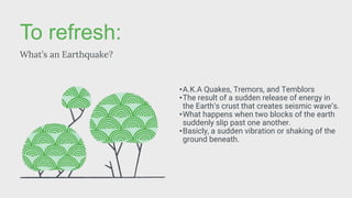
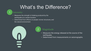
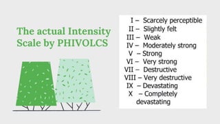
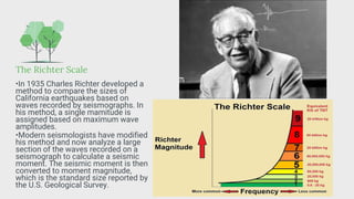
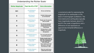
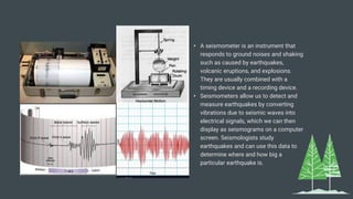
Intensity and
Magnitude
of Earthquakes
To refresh:
What’s an Earthquake?
•A.K.A Quakes, Tremors, and Temblors
•The result of a sudden release of energy in
the Earth’s crust that creates seismic wave’s.
•What happens when two blocks of the earth
suddenly slip past one another.
•Basicly, a sudden vibration or shaking of the
ground beneath.
What’s the Difference?
Intensity
• Measures the strength of shaking produced by the
earthquake at a certain location.
• Determined from effects on people, human structures, and
the natural environment
• Measures the energy released at the source of the
earthquake.
• Determined from measurements on seismographs.
1
2 Magnitude
Intensity
-a number (written as a roman numeral)
describing the severity of an earthquake in
terms of its effects on the earth's surface and
on humans and their structures.
-In Geologiy, it’s a measure of the size of an
earthquake based on observation of the effects
of the shock at the earth's surface.
The actual Intensity
Scale by PHIVOLCS
Example
Elaborate on the concepts with helpful examples
and illustrations. Duplicate this page as many
times as needed to give you more space for
discussion.
Example
Elaborate on the concepts with helpful examples
and illustrations. Duplicate this page as many
times as needed to give you more space for
discussion.
Example
Elaborate on the concepts with helpful examples
and illustrations. Duplicate this page as many
times as needed to give you more space for
discussion.
Example: Moro Gulf Earthquake (1976)
Source: PHIVOLCS
Other Intensity
Scales:
Rossi-Forel Scale
The Rossi–Forel scale was one of the first seismic
scales to represent earthquake intensities. Recorded by a
single seismograph or by some seismographs of the
same pattern, but not by several seismographs of
different kinds; the shock felt by an experienced
observer.
2
Modified Mercalli Scale
The Mercalli Scale is based on observable
earthquake damage. This also uses roman
numerals , but adds the numbers 11 and 12 still
from weakest to strongest the higher it goes, with l
being Intrumental, to Xll being Catastrophic.
1
Magnitude
-a scale that is simply a metric for quantifying
the energy released in an earthquake and the
amplitude of the waves the earthquake emits.
-a number that characterizes the relative size of
an earthquake, In addition, it is based on
measurement of the maximum motion recorded
by a seismograph.
The Richter Scale
•In 1935 Charles Richter developed a
method to compare the sizes of
California earthquakes based on
waves recorded by seismographs. In
his method, a single mamitude is
assigned based on maximum wave
amplitudes.
•Modern seismologists have modified
his method and now analyze a large
section of the waves recorded on a
seismograph to calculate a seismic
moment. The seismic moment is then
converted to moment magnitude,
which is the standard size reported by
the U.S. Geological Survey.
-a numerical scale for expressing the
magnitude of an earthquake on the
basis of seismograph oscillations. The
more destructive earthquakes typically
have magnitudes between about 5.5
and 8.9; the scale is logarithmic and a
difference of one represents an
approximate thirtyfold difference in
magnitude.
Example: Moro Gulf Earthquake (1976)
Source: PHIVOLCS
•The 1976 Moro Gulf earthquake and
tsunami took place on August 17,
1976, at 00:11 local time near the
islands of Mindanao and Sulu, in the
Philippines. Its magnitude was
calculated as being as high as 8.0 on
the moment magnitude scale..
Example: Offshore Batangas Earthquake
(May 2022)
Source: PHIVOLCS and Manila Bulletin
•An offshore earthquake measuring
6.1-magnitude on the Richter scale has
occurred in Batangas at around 5:50
a.m., Sunday, May 22.
•PHIVOLCS traced the epicenter of the
earthquake at 18 kilometers (km)
northwest of Calatagan, Batangas at a
depth of 122 kilometers.
•Intensity said to be about ll-lV.
Example: Abra River Fault Earthquake
(July 2022)
Source: INQUIRER.NET and ACAPS
•The earthquake had a magnitude of
7.0 Mw , with an epicenter in Abra
province. Eleven people were reported
dead and 615 were injured.
•PHIVOLCS has identified the Abra
River Fault as the responsible structure
(PHIVOLCS Poster, 2022) with its
oblique slip. Given the relatively strong
magnitude and shallow depth, the
responsible fault should have reached
the surface, rupturing the ground.
•More than 4,000 aftershocks where
felt in Abra after that 7.0 magnitude
quake, in which the said aftershocks
ranged from a 1.4-5.0 magnitude.
• A seismometer is an instrument that
responds to ground noises and shaking
such as caused by earthquakes,
volcanic eruptions, and explosions.
They are usually combined with a
timing device and a recording device.
• Seismometers allow us to detect and
measure earthquakes by converting
vibrations due to seismic waves into
electrical signals, which we can then
display as seismograms on a computer
screen. Seismologists study
earthquakes and can use this data to
determine where and how big a
particular earthquake is.
Thank you for
listening to today’s
report.
Presenters (from 12-Rutherford):
Nina Angeli Valdez
Janrick Santos

local_media8920084229302980088.pptx

  • 1.
  • 2.
    To refresh: What’s anEarthquake? •A.K.A Quakes, Tremors, and Temblors •The result of a sudden release of energy in the Earth’s crust that creates seismic wave’s. •What happens when two blocks of the earth suddenly slip past one another. •Basicly, a sudden vibration or shaking of the ground beneath.
  • 3.
    What’s the Difference? Intensity •Measures the strength of shaking produced by the earthquake at a certain location. • Determined from effects on people, human structures, and the natural environment • Measures the energy released at the source of the earthquake. • Determined from measurements on seismographs. 1 2 Magnitude
  • 4.
    Intensity -a number (writtenas a roman numeral) describing the severity of an earthquake in terms of its effects on the earth's surface and on humans and their structures. -In Geologiy, it’s a measure of the size of an earthquake based on observation of the effects of the shock at the earth's surface.
  • 5.
    The actual Intensity Scaleby PHIVOLCS Example Elaborate on the concepts with helpful examples and illustrations. Duplicate this page as many times as needed to give you more space for discussion. Example Elaborate on the concepts with helpful examples and illustrations. Duplicate this page as many times as needed to give you more space for discussion. Example Elaborate on the concepts with helpful examples and illustrations. Duplicate this page as many times as needed to give you more space for discussion.
  • 6.
    Example: Moro GulfEarthquake (1976) Source: PHIVOLCS
  • 7.
    Other Intensity Scales: Rossi-Forel Scale TheRossi–Forel scale was one of the first seismic scales to represent earthquake intensities. Recorded by a single seismograph or by some seismographs of the same pattern, but not by several seismographs of different kinds; the shock felt by an experienced observer. 2 Modified Mercalli Scale The Mercalli Scale is based on observable earthquake damage. This also uses roman numerals , but adds the numbers 11 and 12 still from weakest to strongest the higher it goes, with l being Intrumental, to Xll being Catastrophic. 1
  • 8.
    Magnitude -a scale thatis simply a metric for quantifying the energy released in an earthquake and the amplitude of the waves the earthquake emits. -a number that characterizes the relative size of an earthquake, In addition, it is based on measurement of the maximum motion recorded by a seismograph.
  • 9.
    The Richter Scale •In1935 Charles Richter developed a method to compare the sizes of California earthquakes based on waves recorded by seismographs. In his method, a single mamitude is assigned based on maximum wave amplitudes. •Modern seismologists have modified his method and now analyze a large section of the waves recorded on a seismograph to calculate a seismic moment. The seismic moment is then converted to moment magnitude, which is the standard size reported by the U.S. Geological Survey.
  • 10.
    -a numerical scalefor expressing the magnitude of an earthquake on the basis of seismograph oscillations. The more destructive earthquakes typically have magnitudes between about 5.5 and 8.9; the scale is logarithmic and a difference of one represents an approximate thirtyfold difference in magnitude.
  • 11.
    Example: Moro GulfEarthquake (1976) Source: PHIVOLCS •The 1976 Moro Gulf earthquake and tsunami took place on August 17, 1976, at 00:11 local time near the islands of Mindanao and Sulu, in the Philippines. Its magnitude was calculated as being as high as 8.0 on the moment magnitude scale..
  • 12.
    Example: Offshore BatangasEarthquake (May 2022) Source: PHIVOLCS and Manila Bulletin •An offshore earthquake measuring 6.1-magnitude on the Richter scale has occurred in Batangas at around 5:50 a.m., Sunday, May 22. •PHIVOLCS traced the epicenter of the earthquake at 18 kilometers (km) northwest of Calatagan, Batangas at a depth of 122 kilometers. •Intensity said to be about ll-lV.
  • 13.
    Example: Abra RiverFault Earthquake (July 2022) Source: INQUIRER.NET and ACAPS •The earthquake had a magnitude of 7.0 Mw , with an epicenter in Abra province. Eleven people were reported dead and 615 were injured. •PHIVOLCS has identified the Abra River Fault as the responsible structure (PHIVOLCS Poster, 2022) with its oblique slip. Given the relatively strong magnitude and shallow depth, the responsible fault should have reached the surface, rupturing the ground. •More than 4,000 aftershocks where felt in Abra after that 7.0 magnitude quake, in which the said aftershocks ranged from a 1.4-5.0 magnitude.
  • 14.
    • A seismometeris an instrument that responds to ground noises and shaking such as caused by earthquakes, volcanic eruptions, and explosions. They are usually combined with a timing device and a recording device. • Seismometers allow us to detect and measure earthquakes by converting vibrations due to seismic waves into electrical signals, which we can then display as seismograms on a computer screen. Seismologists study earthquakes and can use this data to determine where and how big a particular earthquake is.
  • 15.
    Thank you for listeningto today’s report. Presenters (from 12-Rutherford): Nina Angeli Valdez Janrick Santos