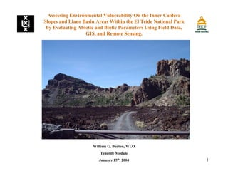
This document presents a research proposal to assess environmental vulnerability on the inner caldera slopes and Llano Basin areas of El Teide National Park on Tenerife, Canary Islands. The study will evaluate abiotic and biotic parameters using field data, GIS and remote sensing. The methodology includes preliminary work, field work, and developing a GIS model. Analysis will include landslide hazard scoring and mapping of fauna, flora and classified remote sensing images. The goal is to evaluate natural and man-made environmental risks and determine if the analyses can be applied more broadly.


![Princeton Sei Presentation August 19 [Compatibility Mode]](https://cdn.slidesharecdn.com/ss_thumbnails/princetonseipresentationaugust19compatibilitymode-12519959913532-phpapp02-thumbnail.jpg?width=640&height=640&fit=bounds)


