soils2
•
0 likes•103 views
This document discusses assessing environmental vulnerability on the slopes and basin areas within El Teide National Park on Tenerife by evaluating abiotic and biotic parameters using field data, geographic information systems (GIS), and remote sensing. Specifically, it aims to analyze buried soils on the slopes and in the Llano basin area through collecting field data and using GIS and remote sensing tools to evaluate factors like soil properties and vegetation patterns that impact environmental vulnerability in the park.
Report
Share
Report
Share
Download to read offline

Recommended
transect1
This document discusses assessing environmental vulnerability in the El Teide National Park in Tenerife, Spain. Field work was conducted to collect data on abiotic and biotic parameters within the caldera slopes and Llano Basin areas of the park. Geographic information systems and remote sensing were utilized to analyze the study area transects and evaluate environmental vulnerability.
geology
The document discusses assessing environmental vulnerability in the inner caldera slopes and Llano Basin areas of El Teide National Park on Tenerife by evaluating abiotic and biotic parameters using field data, GIS, and remote sensing. The study is being conducted by Universiteit van Amsterdam.
Llano_del_cedro_main01
This document presents a research proposal to assess environmental vulnerability on the inner caldera slopes and Llano Basin areas of El Teide National Park on Tenerife, Canary Islands. The study will evaluate abiotic and biotic parameters using field data, GIS and remote sensing. The methodology includes preliminary work, field work, and developing a GIS model. Analysis will include landslide hazard scoring and mapping of fauna, flora and classified remote sensing images. The goal is to evaluate natural and man-made environmental risks and determine if the analyses can be applied more broadly.
Will.Stangroom - Resume
William Stangroom has a Bachelor's degree in Environmental Science from Widener University. He has over 5 years of experience working as a lab technician and field technician conducting environmental testing and emissions monitoring. His technical skills include experience with analytical instruments such as ICP, GC, HPLC and spectroscopy. He is proficient in GIS software and environmental monitoring equipment.
Pre and Post fire vegetation behavioral trends from satellite MODIS/NDVI time...
Pre and Post fire vegetation behavioral trends from satellite MODIS/NDVI time series in semi-natural areas
Tiziana Montesano, Antonio Lanorte, Fortunato De Santis, Rosa Lasaponara - Institute of Methodologies for Environmental Analysis, National Research Council, Italy
Poster Fundamentos de investigación
The document characterizes the natural regeneration of sessile oak (Quercus petraea) in three microhabitats (B, M1, M2) present in a reclaimed coal mine in Northern Palencia, Spain. Seedling characteristics such as height, diameter, dead branches, and density differed significantly among microhabitats. Environmental conditions like light level, moisture, shrub protection, and aspect influenced seedling survival, with higher survival found in microhabitats with more shrub protection and moisture.
Daniel_Bower_Resume
Daniel P. Bower has a B.S. in Geobiology from Penn State University and experience in environmental work, laboratory work, and research. He currently works as an Environmental Specialist for the Merrill W. Linn Environmental Conservancy, where he conducts water sampling and educates the public. Previously he has worked as a Specimen Processing Technician at Mount Nittany Medical Center and as a Laboratory Technician at Great Western Malting. His research experience includes developing an independent thesis on phosphate cycling in a meromictic lake and investigating the effects of climate change on invasive plant species.
8247 pdf
This document summarizes a study that evaluated the use of remote sensing to monitor maize (Zea mays L.) phenology. The study monitored maize fields in Nebraska in 2001 and 2002 using visible atmospherically resistant indices (VARI) derived from spectral reflectance data. The VARI allowed detection of: (1) changes due to biomass accumulation, (2) changes induced by appearance and development of reproductive organs, and (3) onset of senescence, earlier than vegetation indices like NDVI. The VARI identified timing of phenological transitions related to maize physiological development and onset of the grain-fill period, which is important for maximum yield. The remote sensing approach provided a synoptic view of crop development
3D_map
This document discusses assessing environmental vulnerability in the El Teide National Park in Tenerife, Spain. Field data, GIS mapping, and remote sensing are used to evaluate abiotic and biotic parameters on the inner caldera slopes and Llano Basin areas. Specific GIS maps of the Llano Del Cedro area are presented in both 2D and 3D views to assess environmental vulnerability.
hazards_scoring
This document discusses assessing environmental vulnerability on slopes and areas within El Teide National Park. It evaluates abiotic and biotic parameters using field data, GIS, and remote sensing to score slide hazards. The scoring will help understand environmental vulnerability in different areas of the park.
county_weeds01
Butte County is requesting $237,000 to augment its three-year Weed Abatement Program to purchase a GIS mapping system, hire staff, conduct outreach, and eradicate noxious weeds. The funds would support salaries for a GIS analyst, technician, and field technicians, as well as equipment like a computer, plotter, and GPS. The program aims to map and remove over 200 weed infestations across the county's difficult terrain to protect agriculture, wildlife, and human health. The county will contribute over $313,000 in additional funding, equipment, and volunteer labor to fully implement the three-year program.
CACLU_september_newsletter_electronica
The document summarizes an upcoming event hosted by the Chico Chapter of the ACLU featuring Mike German, a former FBI agent who is now a policy counsel for the ACLU. The event will be the chapter's annual dinner on September 29th. German will give a keynote address about his experience in the FBI and transition to working for civil liberties. The dinner will raise funds for the chapter through a catered meal and silent auction. German's itinerary also includes speaking engagements at CSU Chico to discuss challenging terrorism policies and his work at the ACLU.
bidwell_soils1
This document contains a map and data about soil types found in Upper Bidwell Park, Butte County, California. The map shows the park boundary and streams overlaid with symbols representing 16 different soil complexes found in the area. A legend provides the map symbol, soil complex name and description for each type. Soil complexes are grouped based on location such as alluvial soils, terraces, ridgetops, slopes and colluvium. Slopes and ridgetops further differentiate soil types by elevation.
public_hearing02
1. The document discusses the potential local impacts of laws like the USA PATRIOT Act and executive orders on the Chico Police Department, including increased surveillance of citizens, cooperation with federal Joint Terrorism Task Forces, and enforcing immigration law.
2. Key impacts could include surveillance of political and religious groups, delayed search warrants, increased cyber monitoring, and gathering records from libraries and businesses without notifications.
3. The Chico Police Department may be called on to join an FBI-led task force and engage in more local surveillance related to counterterrorism duties.
report_final
This document describes a project to derive geomorphological regions in Cotopaxi Province, Ecuador using GIS. Spatial data from various sources was analyzed using ArcGIS. An unsupervised classification was performed based on elevation and slope data to identify regions of similar geomorphology. The project area around Quilotoa volcano was used to assess the accuracy of the classification by correlating the derived geomorphological regions with soil and precipitation data. The results identified some limitations of the classification approach but also areas of correlation between geomorphology, soils, and precipitation patterns.
cotopaxi_analysis01
This study used GIS tools and spatial data to derive theoretical geomorphology landscape units in Cotopaxi Province, Ecuador. Morphometric criteria including elevation and slope were used to create 60 geomorphic classes. The derived geomorphology regions were then correlated with soil and precipitation data. Though volcanic and glacial processes were not perfectly predicted, other derived regions like alluvial and mass movement areas corresponded well with observations. The young volcanic landscape made it difficult to account for all simultaneous surface processes using only elevation and slope metrics.
topography
This document discusses deriving the geomorphological regions in Cotopaxi Province, Ecuador. It analyzes the landscape and terrain features of the province. The goal is to classify the different landforms and develop a regionalization scheme for Cotopaxi Province based on geomorphology.
chico_homeless_analysis_031107
The document is a map of the south Chico area that shows parcels, streets, highways, streams, lakes, railroads, and the Chico sphere of influence boundary. It includes labels for parcels that were identified in the shelter site selection process. The map provides location context for discussing potential emergency shelter sites in south Chico.
township_view1
This document contains a list of geographic coordinates and place names. It includes township and range designations like T18N, R3E as well as city, road, and ranch names across northern California. The townships and ranges span from T17N to T26N and R1E to R8E, covering a large geographic region. Place names include cities like Chico and Oroville, roads like Skyway and Hwy 99, and Spanish ranchos including Rancho Bosquejo and Rancho Aguas Frias.
Dalmatian Toadflax
Dalmatian toadflax is an invasive perennial plant native to the Mediterranean. It was introduced to North America as an ornamental in the 1800s and has since spread widely, disrupting native ecosystems. It reproduces rapidly through seeds and underground roots, forming dense colonies that outcompete other vegetation. Management is difficult due to its extensive root system and high seed production. Control methods include herbicides, pulling, and preventing further spread and establishment.
chapman_annexation_15_17_letter3
This document contains a map and list of 375 parcels proposed for annexation into the City of Chico as part of the Chapman Neighborhood Annexation No. 1. The map shows the parcels outlined in red within the existing city limits of Chico in blue. It also labels the relevant Assessor's Parcel Numbers for each parcel proposed for annexation. The Butte Local Agency Formation Commission will consider the annexation application from the City of Chico at their July 2, 2014 meeting.
butte_county_weeds03
This document provides guidance on developing a standardized weed mapping program for the California Department of Food and Agriculture (CDFA). The goals are to increase the effectiveness of CDFA's statewide weed management program by implementing integrated weed mapping on local and state levels. The document covers various methods for data assembly and acquisition, including hand mapping, GPS mapping, computer mapping, and applications of geographic information systems (GIS) to analyze spatial distributions of weeds and compare infestations over historical time periods. Standardized mapping across agencies and personnel will help quantify weed management plans, identify problem areas, understand invasion processes, and allocate resources more effectively.
hecho_mapa
Un mapa proporciona información sobre ubicaciones, destinos y características. Existen diferentes tipos de mapas como los de carreteras, idiomas, climas e imágenes. Los elementos clave de un mapa son la flecha de norte, el título, la leyenda, la escala y la frontera. El documento explica cómo dibujar un mapa trazando primero la frontera, los rasgos principales, la leyenda, la flecha del norte, el título y la escala.
More Related Content
Viewers also liked
3D_map
This document discusses assessing environmental vulnerability in the El Teide National Park in Tenerife, Spain. Field data, GIS mapping, and remote sensing are used to evaluate abiotic and biotic parameters on the inner caldera slopes and Llano Basin areas. Specific GIS maps of the Llano Del Cedro area are presented in both 2D and 3D views to assess environmental vulnerability.
hazards_scoring
This document discusses assessing environmental vulnerability on slopes and areas within El Teide National Park. It evaluates abiotic and biotic parameters using field data, GIS, and remote sensing to score slide hazards. The scoring will help understand environmental vulnerability in different areas of the park.
county_weeds01
Butte County is requesting $237,000 to augment its three-year Weed Abatement Program to purchase a GIS mapping system, hire staff, conduct outreach, and eradicate noxious weeds. The funds would support salaries for a GIS analyst, technician, and field technicians, as well as equipment like a computer, plotter, and GPS. The program aims to map and remove over 200 weed infestations across the county's difficult terrain to protect agriculture, wildlife, and human health. The county will contribute over $313,000 in additional funding, equipment, and volunteer labor to fully implement the three-year program.
CACLU_september_newsletter_electronica
The document summarizes an upcoming event hosted by the Chico Chapter of the ACLU featuring Mike German, a former FBI agent who is now a policy counsel for the ACLU. The event will be the chapter's annual dinner on September 29th. German will give a keynote address about his experience in the FBI and transition to working for civil liberties. The dinner will raise funds for the chapter through a catered meal and silent auction. German's itinerary also includes speaking engagements at CSU Chico to discuss challenging terrorism policies and his work at the ACLU.
bidwell_soils1
This document contains a map and data about soil types found in Upper Bidwell Park, Butte County, California. The map shows the park boundary and streams overlaid with symbols representing 16 different soil complexes found in the area. A legend provides the map symbol, soil complex name and description for each type. Soil complexes are grouped based on location such as alluvial soils, terraces, ridgetops, slopes and colluvium. Slopes and ridgetops further differentiate soil types by elevation.
public_hearing02
1. The document discusses the potential local impacts of laws like the USA PATRIOT Act and executive orders on the Chico Police Department, including increased surveillance of citizens, cooperation with federal Joint Terrorism Task Forces, and enforcing immigration law.
2. Key impacts could include surveillance of political and religious groups, delayed search warrants, increased cyber monitoring, and gathering records from libraries and businesses without notifications.
3. The Chico Police Department may be called on to join an FBI-led task force and engage in more local surveillance related to counterterrorism duties.
report_final
This document describes a project to derive geomorphological regions in Cotopaxi Province, Ecuador using GIS. Spatial data from various sources was analyzed using ArcGIS. An unsupervised classification was performed based on elevation and slope data to identify regions of similar geomorphology. The project area around Quilotoa volcano was used to assess the accuracy of the classification by correlating the derived geomorphological regions with soil and precipitation data. The results identified some limitations of the classification approach but also areas of correlation between geomorphology, soils, and precipitation patterns.
cotopaxi_analysis01
This study used GIS tools and spatial data to derive theoretical geomorphology landscape units in Cotopaxi Province, Ecuador. Morphometric criteria including elevation and slope were used to create 60 geomorphic classes. The derived geomorphology regions were then correlated with soil and precipitation data. Though volcanic and glacial processes were not perfectly predicted, other derived regions like alluvial and mass movement areas corresponded well with observations. The young volcanic landscape made it difficult to account for all simultaneous surface processes using only elevation and slope metrics.
topography
This document discusses deriving the geomorphological regions in Cotopaxi Province, Ecuador. It analyzes the landscape and terrain features of the province. The goal is to classify the different landforms and develop a regionalization scheme for Cotopaxi Province based on geomorphology.
chico_homeless_analysis_031107
The document is a map of the south Chico area that shows parcels, streets, highways, streams, lakes, railroads, and the Chico sphere of influence boundary. It includes labels for parcels that were identified in the shelter site selection process. The map provides location context for discussing potential emergency shelter sites in south Chico.
township_view1
This document contains a list of geographic coordinates and place names. It includes township and range designations like T18N, R3E as well as city, road, and ranch names across northern California. The townships and ranges span from T17N to T26N and R1E to R8E, covering a large geographic region. Place names include cities like Chico and Oroville, roads like Skyway and Hwy 99, and Spanish ranchos including Rancho Bosquejo and Rancho Aguas Frias.
Dalmatian Toadflax
Dalmatian toadflax is an invasive perennial plant native to the Mediterranean. It was introduced to North America as an ornamental in the 1800s and has since spread widely, disrupting native ecosystems. It reproduces rapidly through seeds and underground roots, forming dense colonies that outcompete other vegetation. Management is difficult due to its extensive root system and high seed production. Control methods include herbicides, pulling, and preventing further spread and establishment.
chapman_annexation_15_17_letter3
This document contains a map and list of 375 parcels proposed for annexation into the City of Chico as part of the Chapman Neighborhood Annexation No. 1. The map shows the parcels outlined in red within the existing city limits of Chico in blue. It also labels the relevant Assessor's Parcel Numbers for each parcel proposed for annexation. The Butte Local Agency Formation Commission will consider the annexation application from the City of Chico at their July 2, 2014 meeting.
butte_county_weeds03
This document provides guidance on developing a standardized weed mapping program for the California Department of Food and Agriculture (CDFA). The goals are to increase the effectiveness of CDFA's statewide weed management program by implementing integrated weed mapping on local and state levels. The document covers various methods for data assembly and acquisition, including hand mapping, GPS mapping, computer mapping, and applications of geographic information systems (GIS) to analyze spatial distributions of weeds and compare infestations over historical time periods. Standardized mapping across agencies and personnel will help quantify weed management plans, identify problem areas, understand invasion processes, and allocate resources more effectively.
hecho_mapa
Un mapa proporciona información sobre ubicaciones, destinos y características. Existen diferentes tipos de mapas como los de carreteras, idiomas, climas e imágenes. Los elementos clave de un mapa son la flecha de norte, el título, la leyenda, la escala y la frontera. El documento explica cómo dibujar un mapa trazando primero la frontera, los rasgos principales, la leyenda, la flecha del norte, el título y la escala.
Viewers also liked (18)
soils2
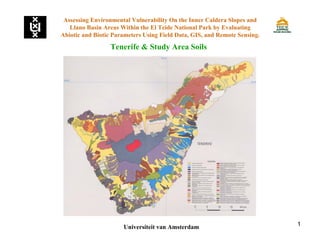
- 1. 1 Tenerife & Study Area Soils Assessing Environmental Vulnerability On the Inner Caldera Slopes and Llano Basin Areas Within the El Teide National Park by Evaluating Abiotic and Biotic Parameters Using Field Data, GIS, and Remote Sensing. Universiteit van Amsterdam
- 2. 2 Tenerife: Buried Soils Assessing Environmental Vulnerability On the Inner Caldera Slopes and Llano Basin Areas Within the El Teide National Park by Evaluating Abiotic and Biotic Parameters Using Field Data, GIS, and Remote Sensing. Universiteit van Amsterdam