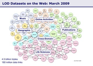
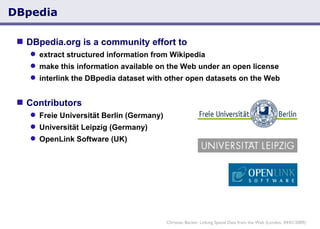
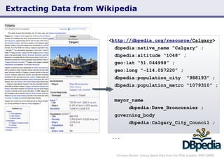
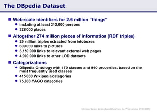
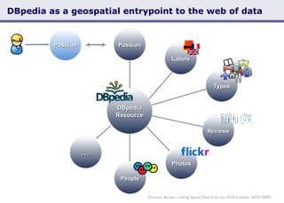
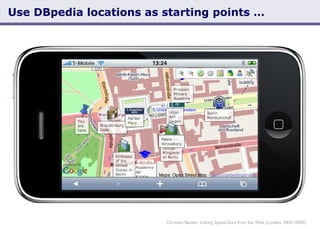
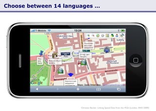
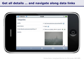
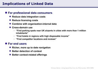
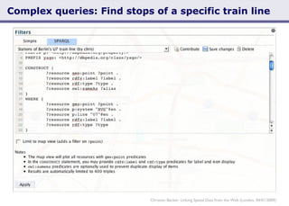
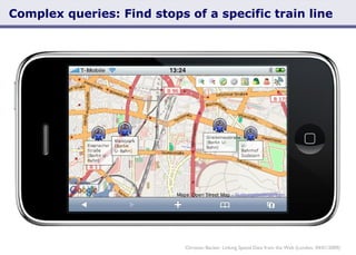
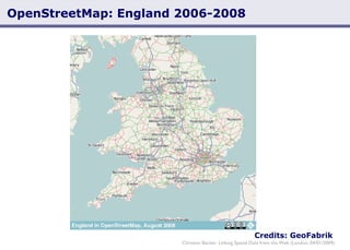
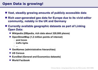
European Geodemographics Conference London, April 1, 2009   Linking Spatial Data from the Web Christian Becker, Freie Universität Berlin Christian Becker: Linking Spatial Data from the Web (London, 04/01/2009)
Hello Name  Christian Becker Job  Partner, MES (consulting) PhD Student at Freie Universität Berlin Semantic Web Projects DBpedia and DBpedia Mobile Marbles Browser BBC interlinking project D2RQ and D2R Server flickr™ wrappr Christian Becker: Linking Spatial Data from the Web (London, 04/01/2009)
Overview Linked Data DBpedia as a Geospatial Entrypoint to the Web of (Linked) Data Implications of Linked Data for Geodemographics Christian Becker: Linking Spatial Data from the Web (London, 04/01/2009)
Linked Data Christian Becker: Linking Spatial Data from the Web (London, 04/01/2009)
We live in a world of data Christian Becker: Linking Spatial Data from the Web (London, 04/01/2009) http://en.wikipedia.org/ wiki/Belgrave_Square Everything around us is online  Things: Wikipedia, Maps, Review sites People: Facebook, LinkedIn, Wikipedia Many things are uniquely identified: Every Wikipedia article Every street corner Every social network profile
We live in a world of data Now that we have identified resources, we can link them (to express information) Linked Data  allows to realize this on a global scale Allows links to be  cross-database ,  cross-organizational  and  cross-domain , much like links on websites A concept by Tim Berners-Lee, inventor of the Web Christian Becker: Linking Spatial Data from the Web (London, 04/01/2009) Christian Christian’s Talk Belgrave Square Society of  Chemical Industry MRS at located at organized by holds ... ... ...
Linked Data as part of the Semantic Web Definition “ The Semantic Web is an evolving extension of the World Wide Web  in which the semantics of information and services on the web is defined , making it possible for the web to understand and satisfy the requests of people and machines to use the web content.”  (Wikipedia) The term “Semantic Web” encompasses general design principles and standards and has sprouted many different areas of research Linked Data Small set of core principles Aims to get actual data published on the Web Semantic Web put to practice Christian Becker: Linking Spatial Data from the Web (London, 04/01/2009)
W3C Linking Open Data Project Community effort to publish existing open license datasets as Linked Data on the Web interlink things between different data sources Christian Becker: Linking Spatial Data from the Web (London, 04/01/2009)
LOD Datasets on the Web: May 2007 Christian Becker: Linking Spatial Data from the Web (London, 04/01/2009) 500 million RDF triples  120,000 data links between data sources
LOD Datasets on the Web: September 2008 Christian Becker: Linking Spatial Data from the Web (London, 04/01/2009)
LOD Datasets on the Web: March 2009 Christian Becker: Linking Spatial Data from the Web (London, 04/01/2009) 4.5 billion triples  180 million data links
LOD Datasets on the Web: March 2009 Christian Becker: Linking Spatial Data from the Web (London, 04/01/2009) 4.5 billion triples  180 million data links Life Sciences Publications Online Activities Music Geographic Cross-Domain
DBpedia as a Geospatial Entrypoint to the Web of (Linked) Data Christian Becker: Linking Spatial Data from the Web (London, 04/01/2009)
DBpedia  DBpedia.org is a community effort to extract structured information from Wikipedia make this information available on the Web under an open license interlink the DBpedia dataset with other open datasets on the Web   Contributors Freie Universität Berlin (Germany) Universität Leipzig (Germany) OpenLink Software (UK) Christian Becker: Linking Spatial Data from the Web (London, 04/01/2009)
Extracting Data from Wikipedia Christian Becker: Linking Spatial Data from the Web (London, 04/01/2009) < http://dbpedia.org/resource/ Calgary >   dbpedia:native_name “Calgary” ;   dbpedia:altitude “1048” ; geo:lat “51.044998” ;   geo:long “-114.057220” ; dbpedia:population_city  “988193” ;   dbpedia:population_metro “1079310” ;    mayor_name    dbpedia:Dave_Bronconnier ;   governing_body  dbpedia:Calgary_City_Council ; ...
The DBpedia Dataset Web-scale identifiers for 2.6 million “things” including at least 213,000 persons  328,000 places  Altogether 274 million pieces of information (RDF triples)  29 million triples extracted from infoboxes 609,000 links to pictures 3,150,000 links to relevant external web pages 4,900,000 links to other LOD datasets Categorizations DBpedia Ontology with 170 classes and 940 properties, based on the most frequently used classes 415,000 Wikipedia categories 75,000 YAGO categories Christian Becker: Linking Spatial Data from the Web (London, 04/01/2009)
DBpedia as a geospatial entrypoint to the web of data Christian Becker: Linking Spatial Data from the Web (London, 04/01/2009) Labels Types Position Photos Reviews People Position DBpedia Resource ...
Potential uses for DBpedia in a mobile context Active Explore the area (DBpedia Mobile)  Local search Complex queries e.g. show me the stops of a specific train line Passive Detect the user’s location - not simply as coordinates, but as a data resource that can be analyzed and act accordingly Museum: Silence the phone Airport: Show current flights Pub, concert: Show nearby friends Christian Becker: Linking Spatial Data from the Web (London, 04/01/2009)
DBpedia Mobile Christian Becker: Linking Spatial Data from the Web (London, 04/01/2009)
Use DBpedia locations as starting points … Christian Becker: Linking Spatial Data from the Web (London, 04/01/2009)
Choose between 14 languages … Christian Becker: Linking Spatial Data from the Web (London, 04/01/2009)
Get more details … Christian Becker: Linking Spatial Data from the Web (London, 04/01/2009)
Get all details … and navigate along data links Christian Becker: Linking Spatial Data from the Web (London, 04/01/2009)
Implications of Linked Data for Geodemographics Christian Becker: Linking Spatial Data from the Web (London, 04/01/2009)
Implications of Linked Data For professional data consumers Reduce data integration costs Reduce licensing costs Combine with organization-internal data Cross-domain use “ Find parking spots near UK airports in cities with more than 1 million inhabitants” “ Find hotels in regions with high disposable income” “ Find competitor locations and reviews” For end users Richer, more up to date navigation Better detection of context  Better context-related offerings Christian Becker: Linking Spatial Data from the Web (London, 04/01/2009)
Complex queries: Find stops of a specific train line Christian Becker: Linking Spatial Data from the Web (London, 04/01/2009)
Complex queries: Find stops of a specific train line Christian Becker: Linking Spatial Data from the Web (London, 04/01/2009) Text
Credits: GeoFabrik Christian Becker: Linking Spatial Data from the Web (London, 04/01/2009) OpenStreetMap: England 2006-2008
Open Data is growing! Vast, steadily growing amounts of publicly accessible data Rich user-generated geo data for Europe due to its vivid editor community, notably in the UK and Germany  Currently available geographic datasets as part of Linking Open Data: Wikipedia (DBpedia, rich data about 328,000 places) OpenStreetMap (1.2 million points of interest) post boxes traffic lights ... GeoNames (administrative hierarchies) US Census EuroStat (General and Economics datasets) World Factbook Christian Becker: Linking Spatial Data from the Web (London, 04/01/2009)
Current Status of Linked Data W3C-approved standards for cross-database, cross-organizational, cross-domain interoperability Datasets and links are not perfect, but graduating beyond a research stage Adoption by data providers and support by major players BBC Thomson Reuters Cyc Foundation Life Sciences community W3C Large amounts of data that are yet untapped Open government data User-generated data such as reviews and locations Christian Becker: Linking Spatial Data from the Web (London, 04/01/2009)
Thanks Questions? References Tim Berners-Lee’s TED Talk http://www.ted.com/index.php/talks/tim_berners_lee_on_the_next_web.html LinkedData.org OpenStreetMap.org Linked Data version:  LinkedGeoData.org DBpedia.org DBpedia Mobile: http://beckr.org/DBpediaMobile Christian Becker: Linking Spatial Data from the Web (London, 04/01/2009)

Linking Spatial Data From The Web

  • 1.
    European Geodemographics ConferenceLondon, April 1, 2009 Linking Spatial Data from the Web Christian Becker, Freie Universität Berlin Christian Becker: Linking Spatial Data from the Web (London, 04/01/2009)
  • 2.
    Hello Name Christian Becker Job Partner, MES (consulting) PhD Student at Freie Universität Berlin Semantic Web Projects DBpedia and DBpedia Mobile Marbles Browser BBC interlinking project D2RQ and D2R Server flickr™ wrappr Christian Becker: Linking Spatial Data from the Web (London, 04/01/2009)
  • 3.
    Overview Linked DataDBpedia as a Geospatial Entrypoint to the Web of (Linked) Data Implications of Linked Data for Geodemographics Christian Becker: Linking Spatial Data from the Web (London, 04/01/2009)
  • 4.
    Linked Data ChristianBecker: Linking Spatial Data from the Web (London, 04/01/2009)
  • 5.
    We live ina world of data Christian Becker: Linking Spatial Data from the Web (London, 04/01/2009) http://en.wikipedia.org/ wiki/Belgrave_Square Everything around us is online Things: Wikipedia, Maps, Review sites People: Facebook, LinkedIn, Wikipedia Many things are uniquely identified: Every Wikipedia article Every street corner Every social network profile
  • 6.
    We live ina world of data Now that we have identified resources, we can link them (to express information) Linked Data allows to realize this on a global scale Allows links to be cross-database , cross-organizational and cross-domain , much like links on websites A concept by Tim Berners-Lee, inventor of the Web Christian Becker: Linking Spatial Data from the Web (London, 04/01/2009) Christian Christian’s Talk Belgrave Square Society of Chemical Industry MRS at located at organized by holds ... ... ...
  • 7.
    Linked Data aspart of the Semantic Web Definition “ The Semantic Web is an evolving extension of the World Wide Web in which the semantics of information and services on the web is defined , making it possible for the web to understand and satisfy the requests of people and machines to use the web content.” (Wikipedia) The term “Semantic Web” encompasses general design principles and standards and has sprouted many different areas of research Linked Data Small set of core principles Aims to get actual data published on the Web Semantic Web put to practice Christian Becker: Linking Spatial Data from the Web (London, 04/01/2009)
  • 8.
    W3C Linking OpenData Project Community effort to publish existing open license datasets as Linked Data on the Web interlink things between different data sources Christian Becker: Linking Spatial Data from the Web (London, 04/01/2009)
  • 9.
    LOD Datasets onthe Web: May 2007 Christian Becker: Linking Spatial Data from the Web (London, 04/01/2009) 500 million RDF triples 120,000 data links between data sources
  • 10.
    LOD Datasets onthe Web: September 2008 Christian Becker: Linking Spatial Data from the Web (London, 04/01/2009)
  • 11.
    LOD Datasets onthe Web: March 2009 Christian Becker: Linking Spatial Data from the Web (London, 04/01/2009) 4.5 billion triples 180 million data links
  • 12.
    LOD Datasets onthe Web: March 2009 Christian Becker: Linking Spatial Data from the Web (London, 04/01/2009) 4.5 billion triples 180 million data links Life Sciences Publications Online Activities Music Geographic Cross-Domain
  • 13.
    DBpedia as aGeospatial Entrypoint to the Web of (Linked) Data Christian Becker: Linking Spatial Data from the Web (London, 04/01/2009)
  • 14.
    DBpedia DBpedia.orgis a community effort to extract structured information from Wikipedia make this information available on the Web under an open license interlink the DBpedia dataset with other open datasets on the Web Contributors Freie Universität Berlin (Germany) Universität Leipzig (Germany) OpenLink Software (UK) Christian Becker: Linking Spatial Data from the Web (London, 04/01/2009)
  • 15.
    Extracting Data fromWikipedia Christian Becker: Linking Spatial Data from the Web (London, 04/01/2009) < http://dbpedia.org/resource/ Calgary > dbpedia:native_name “Calgary” ; dbpedia:altitude “1048” ; geo:lat “51.044998” ; geo:long “-114.057220” ; dbpedia:population_city “988193” ; dbpedia:population_metro “1079310” ; mayor_name dbpedia:Dave_Bronconnier ; governing_body dbpedia:Calgary_City_Council ; ...
  • 16.
    The DBpedia DatasetWeb-scale identifiers for 2.6 million “things” including at least 213,000 persons 328,000 places Altogether 274 million pieces of information (RDF triples) 29 million triples extracted from infoboxes 609,000 links to pictures 3,150,000 links to relevant external web pages 4,900,000 links to other LOD datasets Categorizations DBpedia Ontology with 170 classes and 940 properties, based on the most frequently used classes 415,000 Wikipedia categories 75,000 YAGO categories Christian Becker: Linking Spatial Data from the Web (London, 04/01/2009)
  • 17.
    DBpedia as ageospatial entrypoint to the web of data Christian Becker: Linking Spatial Data from the Web (London, 04/01/2009) Labels Types Position Photos Reviews People Position DBpedia Resource ...
  • 18.
    Potential uses forDBpedia in a mobile context Active Explore the area (DBpedia Mobile) Local search Complex queries e.g. show me the stops of a specific train line Passive Detect the user’s location - not simply as coordinates, but as a data resource that can be analyzed and act accordingly Museum: Silence the phone Airport: Show current flights Pub, concert: Show nearby friends Christian Becker: Linking Spatial Data from the Web (London, 04/01/2009)
  • 19.
    DBpedia Mobile ChristianBecker: Linking Spatial Data from the Web (London, 04/01/2009)
  • 20.
    Use DBpedia locationsas starting points … Christian Becker: Linking Spatial Data from the Web (London, 04/01/2009)
  • 21.
    Choose between 14languages … Christian Becker: Linking Spatial Data from the Web (London, 04/01/2009)
  • 22.
    Get more details… Christian Becker: Linking Spatial Data from the Web (London, 04/01/2009)
  • 23.
    Get all details… and navigate along data links Christian Becker: Linking Spatial Data from the Web (London, 04/01/2009)
  • 24.
    Implications of LinkedData for Geodemographics Christian Becker: Linking Spatial Data from the Web (London, 04/01/2009)
  • 25.
    Implications of LinkedData For professional data consumers Reduce data integration costs Reduce licensing costs Combine with organization-internal data Cross-domain use “ Find parking spots near UK airports in cities with more than 1 million inhabitants” “ Find hotels in regions with high disposable income” “ Find competitor locations and reviews” For end users Richer, more up to date navigation Better detection of context Better context-related offerings Christian Becker: Linking Spatial Data from the Web (London, 04/01/2009)
  • 26.
    Complex queries: Findstops of a specific train line Christian Becker: Linking Spatial Data from the Web (London, 04/01/2009)
  • 27.
    Complex queries: Findstops of a specific train line Christian Becker: Linking Spatial Data from the Web (London, 04/01/2009) Text
  • 28.
    Credits: GeoFabrik ChristianBecker: Linking Spatial Data from the Web (London, 04/01/2009) OpenStreetMap: England 2006-2008
  • 29.
    Open Data isgrowing! Vast, steadily growing amounts of publicly accessible data Rich user-generated geo data for Europe due to its vivid editor community, notably in the UK and Germany Currently available geographic datasets as part of Linking Open Data: Wikipedia (DBpedia, rich data about 328,000 places) OpenStreetMap (1.2 million points of interest) post boxes traffic lights ... GeoNames (administrative hierarchies) US Census EuroStat (General and Economics datasets) World Factbook Christian Becker: Linking Spatial Data from the Web (London, 04/01/2009)
  • 30.
    Current Status ofLinked Data W3C-approved standards for cross-database, cross-organizational, cross-domain interoperability Datasets and links are not perfect, but graduating beyond a research stage Adoption by data providers and support by major players BBC Thomson Reuters Cyc Foundation Life Sciences community W3C Large amounts of data that are yet untapped Open government data User-generated data such as reviews and locations Christian Becker: Linking Spatial Data from the Web (London, 04/01/2009)
  • 31.
    Thanks Questions? ReferencesTim Berners-Lee’s TED Talk http://www.ted.com/index.php/talks/tim_berners_lee_on_the_next_web.html LinkedData.org OpenStreetMap.org Linked Data version: LinkedGeoData.org DBpedia.org DBpedia Mobile: http://beckr.org/DBpediaMobile Christian Becker: Linking Spatial Data from the Web (London, 04/01/2009)