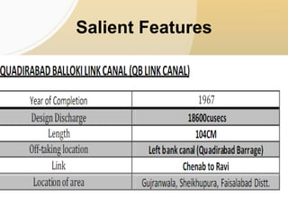
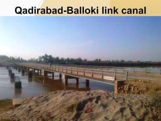
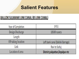
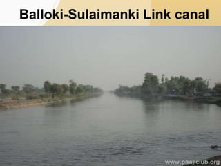
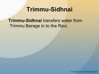
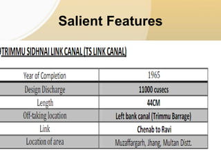
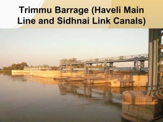
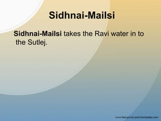
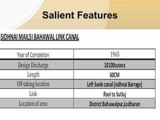
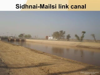
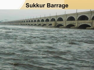
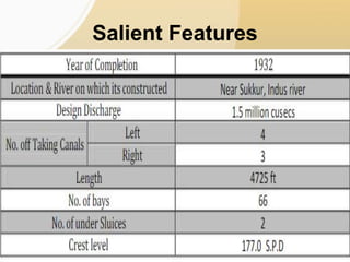
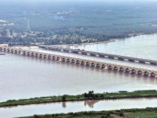
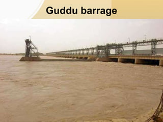
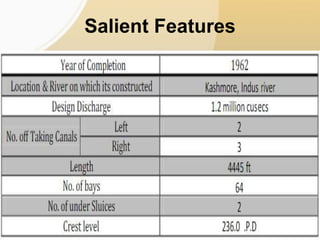
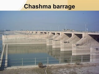
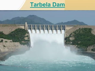
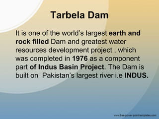
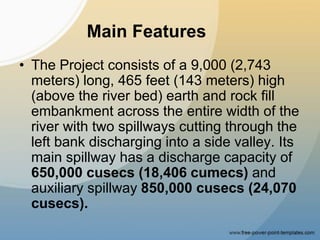
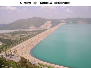
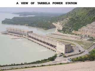
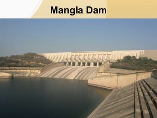
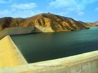
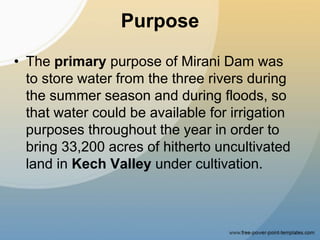
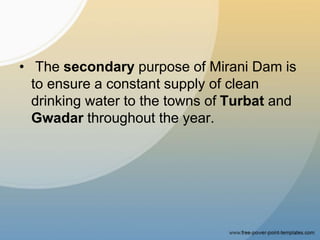
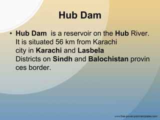
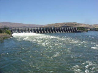
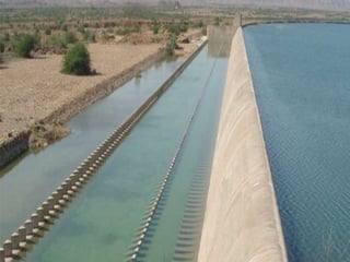
Topic
• Link Canals and their salient features
• Barrages in Pakistan
• Dams in Pakistan
• Presented to
Sir Asif Aslam
• Presented by
Raees Abbas Shah
2011-CE-26
Members
• Abdul Mutlib 2011-CE-17
• M Shahid 2011-CE-32
• Jam Tahir 2011-CE-11
• Sajid Manzoor 2011-CE-21
• Khawar Abbas 2011-CE-16
• Umar Mehmood 2011-CE-37
• Sajjad Deol 2011-CE-29
• Bilal niazi 2011-CE-22
Canal
What is a Canal?
• An artificial waterway for navigation or for
draining or irrigating land.
Canal System of Pakistan
The irrigation and canal system of Pakistan is
regarded as best among others worldwide.
It is also the largest. About three fourth of the
agricultural land of Pakistan comes under this canal
system. At present Pakistan has three large dams
and eighty five small dams in this system.
These dams are controlled by 19 barrages. A total
of 57 canals are included in this system.
Among these 12 are linked and other 45 are normal
canals. In Pakistan canals are the most popular
means of irrigation as they supply plenty of water at
very cheap rates.
History in Subcontinent
• Controlled irrigation began in around 1859
with the completion of the Upper Bari
Doab Canal (UBDC) from Madhopur
Headworks (now in India) on Ravi River.
Until that time, irrigation was undertaken
through a network of inundation canals,
which were functional only during periods
of high river flow. They provided water for
kharif (summer) crops and some soil
moisture for rabi (winter) crops.
Types of canals in Pakistan
• Canal System of Pakistan consist of three
main important types of canals:
• Perennial Canals
• Non-Perennial Canals
• Inundation Canals
Perennial Canals
Perennial canals ensure regular supply of
water all the year round. These canals
supply water to farmer’s field. Perennial
canals sprout from barrages or dams.
These are crucial in canal system of
Pakistan.
Punjab has many of these canals. These
include Lower and upper Bari Doab,
Lower & Upper Chenab canal and
Sidhnai.
• Apart from these Uper Jehlum and river
Sutlej’s Canals are also important. Trimu
Headworks is the starting point of Jhelum
canals. While canals of Sutlej river
originate from it at Islam, Panjnad,
Ferozpur and Sulaimanki Headworks.
Non-Perennial Canals
Non-perennial canals only run in
Monsoon and summer. They get their
water from rains. This category also has
many canals. These include Sutlej,
Sidhnai (from ravi) and haveli (from
chenab) canals. They also constitute an
important part in canal system of Pakistan.
Inundation Canals
Rainy weather and season is the only
time when these canals run. It actually
happens due to raised level of water in
rivers. Uncertain water quantity is supplied
by them. Their source of water is also river
but there is a difference. They carry extra
flood water. That is why these are also
called flood canals. Some canals of
Chenab and Indus river are the examples.
Indus water treaty between India
& Pakistan
• Treaty of Indus Water was signed between
two nations (Pakistan and India) in 1960 due
to the water clashes between them . The
history of this treaty goes back in the early
months after independence. India after
division of Punjab got headwaters of all the
rivers that flow in Pakistan. They on one
occcasion (1948, April) stopped water flow in
Pakistani rivers. Pakistan protested against
this act. An interim solution was sorted out
but the issue was permanently solved in the
form of Indus Water Treaty.
• This treaty guaranteed Pakistan the water
from 3 western rivers. These include
Jehlum, Indus and Chenab. India got
water from the 3 remaining eastern rivers.
These included Ravi, Sutlej and Bias. After
the treaty there started construction of
massive dams in Pakistan. Also, the linked
canals were constructed to sustain the
irrigation system of Pakistan. A total of 8
linked canals were built for this purpose.
Indus Water Treaty was signed in the reign
of General Ayub Khan. So, this treaty
strengthened the Canal system of Pakistan.
Link Canals
• The total length of canals in Pakistan is
about 56,073 km (estimated upto 1999).
• There are ten linked canals found in
Punjab. These were dug after the Indus
Water Treaty.
• We are discussing particular link
canals only.
Link canals
1. Rasul-Qadirabad
2. Qadirabad-Balloki
3. Balloki-Sulaimanki
4. Trimmu-Sidhnai
5. Sidhnai-Mailsi.
6. Mailsi-Bahawal
7. Chashma-Jhellum
8. Taunsa-Punjnad.
Rasul-Qadirabad
Rasul-Qadirabad Links carries water from
Rasul Barrage on the Jhellum to the
Chenab.
Salient Features
CM= Canal Mile
Rasul Qadirabad Link Canal,
Mandi Bahauddin
Qadirabad-Balloki
Qadirabad-Balloki Link is an extension of
Rasul-Qadirabad Link by which the water
is transferred to the Ravi river.
Salient Features
Qadirabad-Balloki link canal
Balloki-Sulaimanki
Balloki-Sulaimanki Link connects the
Ravi and the Sutlej.
Salient Features
Balloki-Sulaimanki Link canal
Trimmu-Sidhnai
Trimmu-Sidhnai transfers water from
Trimmu Barage in to the Ravi.
Salient Features
Trimmu Barrage (Haveli Main
Line and Sidhnai Link Canals)
Sidhnai-Mailsi
Sidhnai-Mailsi takes the Ravi water in to
the Sutlej.
Salient Features
Sidhnai-Mailsi link canal
Mailsi-Bahawal
Mailsi-Bahawal Link supplies water to the
Bahawal Canal.
Salient Features
Mailsi-Bahawal link canal
Chashma-Jhellum
Chashma-Jhellum Link transfers water
from Chashma Barrage on the Indus to the
Jhelum river.
Salient Features
Chashma-Jhellum link canal
Taunsa-Punjnad
Taunsa-Punjnad Link carries water from
Taunsa on the Indus to the Chenab river
to feed the Punjab canals.
Salient Features
Taunsa-Punjnad link canal
Barrage
Barrage
• What is a barrage?
• An artificial structure or obstruction placed
in river or water course , to increase the
depth of water(to some feet), so that the
water can be diverted into canals is called
barrage.
What is difference between
Barrage and Headworks?
• The head works are built on river or water
course between two banks at the same level
of river to control water, distribute it through
canals for irrigation or other purpose of
supplying water.
• Barrage is made in similar way but main
difference is that barrage is designed in such
a way so that it could increase the water level
and serve as a storage. Electricity can be
produced at a barrage after construction of
hydro power plants but could not be at a
head work.
Barrages
• At present pakistan has
• 16 barrages &
• 3 Head Works which include
Barrages
• Qadirabad
• Rasul
• Sidhnai
• Sulemanki
• Taunsa
• Trimmu
• Islam
• Guddu
• Balloki
• Chashma
• Islam
• Jinnah
• Sukkhur
• Kotri
• Marala
• Panjnad
Head Works
• Khanki
• Mangla
• Muhammad wala
Sukkur Barrage
• It is the largest barrage of pakistan and
was build during british rule.
• It was known as Lloyd Barrage.
Salient Features
Guddu barrage
Salient Features
Chashma barrage
Salient Features
Jinnah Barrage
Salient Features
Kotri barrage
• It is also known as Ghulam Muhammad
Barrage.
Salient Features
Taunsa barrage
Salient Features
Khanki Head Works
• Khanki Headworks is
a headworks situated on the River
Chenab in Gujranwala District of
the Punjab province of Pakistan.
• It was constructed in 1889 and is
considered to be the oldest headworks in
Pakistan.
• Khanki Headworks is used for irrigation
and flood control.
Dams
What is a Dam ?
• A dam is a barrier that impounds water or
underground streams. The reservoirs
created by dams not only suppress floods
but provide water for various needs to
include irrigation, human consumption,
industrial use, aquaculture and
navigability.
• A dam is also the basic key element for
hydropower generation.
Dams in Pakistan
• At present Pakistan has three large dams
and eighty five small dams in this system.
These dams are controlled by 19
barrages. A total of 57 canals are included
in this system. Among these 12 are linked
and other 45 are normal canals.
Tarbela Dam
Tarbela Dam
It is one of the world’s largest earth and
rock filled Dam and greatest water
resources development project , which
was completed in 1976 as a component
part of Indus Basin Project. The Dam is
built on Pakistan’s largest river i.e INDUS.
• It is the Largest Earth Filled Dam of Asia.
&
• It is also considered as the biggest Dam of
the world after Syncrude Tailings Dam
(Canada).
Main Features
• The Project consists of a 9,000 (2,743
meters) long, 465 feet (143 meters) high
(above the river bed) earth and rock fill
embankment across the entire width of the
river with two spillways cutting through the
left bank discharging into a side valley. Its
main spillway has a discharge capacity of
650,000 cusecs (18,406 cumecs) and
auxiliary spillway 850,000 cusecs (24,070
cusecs).
Tarbela Reservoir
• The reservoir is 50 miles (80.5 km) long
100 square, miles (260 square kilometers)
in area and has a gross storage capacity
of 11.6 MAF (17.109 million cu. Meters)
with a live storage capacity of 9.7 MAF
(14,307 million cu. Meters). The total
catchment area above Tarbela is spread
over 65,000 sq. miles (168,000 sq.
kilometers)
Tarbela Power station
• A power station on the right bank near the
toe of the main dam houses fourteen(14),
power units, 4 units, each with installed
generating capacity of 175 MW are
installed on tunnel 1
• 6 units (NO.5 to 10), 175 MW each on
tunnel NO.2 and
• 4 Units ( NO.11-14) of 432 MW each on
Tunnel 3, thus making total generating
capacity of Tarbela Power Station as 3478
MW.
Mangla Dam
• The dam was constructed between 1961
to 1967 across the Jhelum River, about 67
miles (108 km) south-east of the Pakistani
capital, Islamabad in Mirpur
District of Azad Kashmir, Pakistan.
• This dam was constructed as a part of
the Indus Waters Treaty signed in 1960.
• The Mangla Dam was the first of the two
dams constructed to reduce this
shortcoming and strengthen the irrigation
system of the country as part of the Indus
Basin Project, the other being Tarbela
Dam on River Indus.
• It is an Embankment Dam.
• And second largest dam of pakistan so far.
Turbine Outflow Stream
General Description
• Height =147 m (482 ft)
• Length =3,140 m (10,302 ft)
• Total capacity
9.12 km3(7,390,000 acre·ft)
• Surface area
97 sq mi (251 km2)
• Installed capacity
1,150 MW
Rawal Lake Dam
Rawal Dam
• Rawal Dam was constructed across the
Korang Nullah in 1960-1962 to supply
water for domestic purpose to the twin
cities of Rawalpindi and Islamabad.
• This 700 feet long concrete dam is a fine
example of stone masonry. With a storage
capacity of 47,500 acre feet, it not only
supplies drinking water to the twin cities
but also irrigates an area of 500 acres.
Rawal Lake dam
General Description
• Type of dam: partly arched gravity dam
(stone masonry)
• Crest level: 1,742 ft (531 m)
• Crest length: 700 ft (210 m)
• Maximum height: 133.5 ft (40.7 m)
Rawal lake
Rawal Lake
• The reservoir of Rawal Dam is called
Rawal Lake and is spread over an area of
8.8 km square .
• It is an artificial reservoir that provides the
water needs for the cities
of Rawalpindi and Islamabad.
• The view of rawal lake and reservoir is
shown in the figure below.
Rawal Lake Dam
Gomal Zam Dam
• Gomal Zam Dam is a
multi-purpose gravity dam in South
Waziristan Agency of Federally
Administered Tribal Areas.
Characteristics
• Gomal Dam is a Roller Compacted
Concrete (RCC) gravity dam with a
height of 437 feet (133 m).
• It produces 17.4 MW of electricity.
• It has a gross storage capacity of
1,140,000 acre feet (1.41 km3) and the
60.5 km long main canal will irrigate about
163,000 acres (660 km2) of barren land.
Purpose
• The purpose of the dam is irrigation, flood
control and Hydoelectric power
generation.
Background
• Construction of the dam began in August
2001 and was completed in April
2011. The powerhouse was completed in
March 2013.
Khanpur Dam
Khanpur Dam
• Khanpur Dam is a dam located on
the Haro River near Potowar
Plateau and the village of Khanpur, KPK
near Islamabad.
• Khanpur dam has a storage capacity of
106,000 acre feet of water and is 67 feet
high.
• Khanpur dam is of prime importance as it
is the primary source of water supply (both
domestic and industrial) to Islamabad and
Rawalpindi the twin city.
• It also irrigates the surrounding agricultural
areas.
Background
• The dam was completed in 1983 after a
15-year construction period.
• It is built adjacent to Khanpur lake.
Khanpur Lake
Warsak Dam
• Warsak Dam is a mass concrete gravity
dam located on the Kabul River near
Peshawar in Khyber Pakhtunkhwa
province.
• Warsak Dam was completed under the
Colombo Plan in two phases and financed
by the Canadian Government.
Warsak Dam
Development & Capacity
• The first phase was completed in 1960
having four units of 40 MV capacity.
• Two additional generating units of 41.48
MW capacity each were added in 1980-81
in the second phase.
• The total installed capacity of the Warsak
Dam Hydropower Project is 243 MW.
Mirani dam
• Mirani Dam is a medium-size
multi-purpose concrete-faced rock-filled
dam located on the Dasht River south of
the Central Makran Range in Kech
District in Balochistan province.
• Mirani Dam was completed in July 2006.
• It is fed by Kech River and the Nihing
River
• It also impounds dasht river.
Purpose
• The primary purpose of Mirani Dam was
to store water from the three rivers during
the summer season and during floods, so
that water could be available for irrigation
purposes throughout the year in order to
bring 33,200 acres of hitherto uncultivated
land in Kech Valley under cultivation.
• The secondary purpose of Mirani Dam is
to ensure a constant supply of clean
drinking water to the towns of Turbat and
Gwadar throughout the year.
Hub Dam
• Hub Dam is a reservoir on the Hub River.
It is situated 56 km from Karachi
city in Karachi and Lasbela
Districts on Sindh and Balochistan provin
ces border.
Characteristics
• The dam is extended to 24300 acres with
gross storage capacity of 857000 acre
feet.
• It is the Pakistan's third largest dam.
• It is an important source that provides the
drinking water to the metropolitan city
Karachi.
Future Projects
• The future projects of pakistan whom need
is inevitable in the current scenerio of
critical energy crisis and flood hazards
include
Diamer-Bhasha Dam
• Diamer-Bhasha Dam is a gravity dam,
in the preliminary stages of construction,
on the River Indus in Pakistan Azad
Kashmir,Gilgit-Baltistan, Pakistan. Its
foundation stone was laid by Prime
Minister Yusuf Raza Gilani of Pakistan on
18 October 2011. Upon completion,
Diamer-Bhasha Dam would be the highest
RCC dam in the world.
Incentives
• Upon completion, Diamer-Bhasha Dam
would Produce 4,500 megawatts of
electricity through environmentally clean
hydropower generation.
• Store an extra 8,500,000 acre feet
(10.5 km3) of water for Pakistan that would
be used for irrigation and drinking.
• Extend the life of Tarbela Dam located
downstream by 35 years.
• and Control flood damage by the River
Indus downstream during high floods.
Kalabagh Dam
• The Kalabagh Dam is a
proposed hydroelectric dam on the Indus
River at Kalabagh in the Mianwali District
of Punjab Province in Pakistan. Intensely
debated and deemed a necessity since its
inception, if constructed the dam would
have 3,600 megawatts (4,800,000 hp) of
electricity generation capacity.
Political Issues
• But due to some severe political biased
behaviors the construction of the dam is
due.
• Sindh and Kpk have issues regarding the
design ,site and outflow including other
issues of the dam.
•Wikipedia
•http://irrigation.punjab.gov.
pk/
• Research journals etc
Link canals, Baraages and Dams

Link canals, Baraages and Dams

  • 2.
    Topic • Link Canalsand their salient features • Barrages in Pakistan • Dams in Pakistan
  • 3.
  • 4.
    • Presented by RaeesAbbas Shah 2011-CE-26
  • 5.
    Members • Abdul Mutlib2011-CE-17 • M Shahid 2011-CE-32 • Jam Tahir 2011-CE-11 • Sajid Manzoor 2011-CE-21 • Khawar Abbas 2011-CE-16 • Umar Mehmood 2011-CE-37 • Sajjad Deol 2011-CE-29 • Bilal niazi 2011-CE-22
  • 6.
  • 7.
    What is aCanal? • An artificial waterway for navigation or for draining or irrigating land.
  • 9.
    Canal System ofPakistan The irrigation and canal system of Pakistan is regarded as best among others worldwide. It is also the largest. About three fourth of the agricultural land of Pakistan comes under this canal system. At present Pakistan has three large dams and eighty five small dams in this system. These dams are controlled by 19 barrages. A total of 57 canals are included in this system. Among these 12 are linked and other 45 are normal canals. In Pakistan canals are the most popular means of irrigation as they supply plenty of water at very cheap rates.
  • 10.
    History in Subcontinent •Controlled irrigation began in around 1859 with the completion of the Upper Bari Doab Canal (UBDC) from Madhopur Headworks (now in India) on Ravi River. Until that time, irrigation was undertaken through a network of inundation canals, which were functional only during periods of high river flow. They provided water for kharif (summer) crops and some soil moisture for rabi (winter) crops.
  • 12.
    Types of canalsin Pakistan • Canal System of Pakistan consist of three main important types of canals: • Perennial Canals • Non-Perennial Canals • Inundation Canals
  • 13.
    Perennial Canals Perennial canalsensure regular supply of water all the year round. These canals supply water to farmer’s field. Perennial canals sprout from barrages or dams. These are crucial in canal system of Pakistan. Punjab has many of these canals. These include Lower and upper Bari Doab, Lower & Upper Chenab canal and Sidhnai.
  • 15.
    • Apart fromthese Uper Jehlum and river Sutlej’s Canals are also important. Trimu Headworks is the starting point of Jhelum canals. While canals of Sutlej river originate from it at Islam, Panjnad, Ferozpur and Sulaimanki Headworks.
  • 16.
    Non-Perennial Canals Non-perennial canalsonly run in Monsoon and summer. They get their water from rains. This category also has many canals. These include Sutlej, Sidhnai (from ravi) and haveli (from chenab) canals. They also constitute an important part in canal system of Pakistan.
  • 18.
    Inundation Canals Rainy weatherand season is the only time when these canals run. It actually happens due to raised level of water in rivers. Uncertain water quantity is supplied by them. Their source of water is also river but there is a difference. They carry extra flood water. That is why these are also called flood canals. Some canals of Chenab and Indus river are the examples.
  • 21.
    Indus water treatybetween India & Pakistan • Treaty of Indus Water was signed between two nations (Pakistan and India) in 1960 due to the water clashes between them . The history of this treaty goes back in the early months after independence. India after division of Punjab got headwaters of all the rivers that flow in Pakistan. They on one occcasion (1948, April) stopped water flow in Pakistani rivers. Pakistan protested against this act. An interim solution was sorted out but the issue was permanently solved in the form of Indus Water Treaty.
  • 23.
    • This treatyguaranteed Pakistan the water from 3 western rivers. These include Jehlum, Indus and Chenab. India got water from the 3 remaining eastern rivers. These included Ravi, Sutlej and Bias. After the treaty there started construction of massive dams in Pakistan. Also, the linked canals were constructed to sustain the irrigation system of Pakistan. A total of 8 linked canals were built for this purpose. Indus Water Treaty was signed in the reign of General Ayub Khan. So, this treaty strengthened the Canal system of Pakistan.
  • 24.
    Link Canals • Thetotal length of canals in Pakistan is about 56,073 km (estimated upto 1999). • There are ten linked canals found in Punjab. These were dug after the Indus Water Treaty. • We are discussing particular link canals only.
  • 25.
    Link canals 1. Rasul-Qadirabad 2.Qadirabad-Balloki 3. Balloki-Sulaimanki 4. Trimmu-Sidhnai 5. Sidhnai-Mailsi. 6. Mailsi-Bahawal 7. Chashma-Jhellum 8. Taunsa-Punjnad.
  • 26.
    Rasul-Qadirabad Rasul-Qadirabad Links carrieswater from Rasul Barrage on the Jhellum to the Chenab.
  • 27.
  • 28.
    Rasul Qadirabad LinkCanal, Mandi Bahauddin
  • 29.
    Qadirabad-Balloki Qadirabad-Balloki Link isan extension of Rasul-Qadirabad Link by which the water is transferred to the Ravi river.
  • 30.
  • 31.
  • 32.
  • 33.
  • 34.
  • 35.
    Trimmu-Sidhnai Trimmu-Sidhnai transfers waterfrom Trimmu Barage in to the Ravi.
  • 36.
  • 37.
    Trimmu Barrage (HaveliMain Line and Sidhnai Link Canals)
  • 38.
    Sidhnai-Mailsi Sidhnai-Mailsi takes theRavi water in to the Sutlej.
  • 39.
  • 40.
  • 41.
  • 42.
  • 43.
  • 44.
    Chashma-Jhellum Chashma-Jhellum Link transferswater from Chashma Barrage on the Indus to the Jhelum river.
  • 45.
  • 46.
  • 47.
    Taunsa-Punjnad Taunsa-Punjnad Link carrieswater from Taunsa on the Indus to the Chenab river to feed the Punjab canals.
  • 48.
  • 49.
  • 50.
  • 51.
    Barrage • What isa barrage? • An artificial structure or obstruction placed in river or water course , to increase the depth of water(to some feet), so that the water can be diverted into canals is called barrage.
  • 52.
    What is differencebetween Barrage and Headworks? • The head works are built on river or water course between two banks at the same level of river to control water, distribute it through canals for irrigation or other purpose of supplying water. • Barrage is made in similar way but main difference is that barrage is designed in such a way so that it could increase the water level and serve as a storage. Electricity can be produced at a barrage after construction of hydro power plants but could not be at a head work.
  • 53.
    Barrages • At presentpakistan has • 16 barrages & • 3 Head Works which include
  • 54.
    Barrages • Qadirabad • Rasul •Sidhnai • Sulemanki • Taunsa • Trimmu • Islam • Guddu • Balloki • Chashma • Islam • Jinnah • Sukkhur • Kotri • Marala • Panjnad
  • 55.
    Head Works • Khanki •Mangla • Muhammad wala
  • 56.
  • 57.
    • It isthe largest barrage of pakistan and was build during british rule. • It was known as Lloyd Barrage.
  • 58.
  • 60.
  • 61.
  • 62.
  • 63.
  • 64.
  • 65.
  • 66.
  • 67.
    • It isalso known as Ghulam Muhammad Barrage.
  • 68.
  • 69.
  • 70.
  • 71.
  • 72.
    • Khanki Headworksis a headworks situated on the River Chenab in Gujranwala District of the Punjab province of Pakistan. • It was constructed in 1889 and is considered to be the oldest headworks in Pakistan. • Khanki Headworks is used for irrigation and flood control.
  • 73.
  • 74.
    What is aDam ? • A dam is a barrier that impounds water or underground streams. The reservoirs created by dams not only suppress floods but provide water for various needs to include irrigation, human consumption, industrial use, aquaculture and navigability. • A dam is also the basic key element for hydropower generation.
  • 75.
    Dams in Pakistan •At present Pakistan has three large dams and eighty five small dams in this system. These dams are controlled by 19 barrages. A total of 57 canals are included in this system. Among these 12 are linked and other 45 are normal canals.
  • 76.
  • 77.
    Tarbela Dam It isone of the world’s largest earth and rock filled Dam and greatest water resources development project , which was completed in 1976 as a component part of Indus Basin Project. The Dam is built on Pakistan’s largest river i.e INDUS.
  • 78.
    • It isthe Largest Earth Filled Dam of Asia. & • It is also considered as the biggest Dam of the world after Syncrude Tailings Dam (Canada).
  • 79.
    Main Features • TheProject consists of a 9,000 (2,743 meters) long, 465 feet (143 meters) high (above the river bed) earth and rock fill embankment across the entire width of the river with two spillways cutting through the left bank discharging into a side valley. Its main spillway has a discharge capacity of 650,000 cusecs (18,406 cumecs) and auxiliary spillway 850,000 cusecs (24,070 cusecs).
  • 80.
    Tarbela Reservoir • Thereservoir is 50 miles (80.5 km) long 100 square, miles (260 square kilometers) in area and has a gross storage capacity of 11.6 MAF (17.109 million cu. Meters) with a live storage capacity of 9.7 MAF (14,307 million cu. Meters). The total catchment area above Tarbela is spread over 65,000 sq. miles (168,000 sq. kilometers)
  • 82.
    Tarbela Power station •A power station on the right bank near the toe of the main dam houses fourteen(14), power units, 4 units, each with installed generating capacity of 175 MW are installed on tunnel 1 • 6 units (NO.5 to 10), 175 MW each on tunnel NO.2 and • 4 Units ( NO.11-14) of 432 MW each on Tunnel 3, thus making total generating capacity of Tarbela Power Station as 3478 MW.
  • 84.
  • 85.
    • The damwas constructed between 1961 to 1967 across the Jhelum River, about 67 miles (108 km) south-east of the Pakistani capital, Islamabad in Mirpur District of Azad Kashmir, Pakistan. • This dam was constructed as a part of the Indus Waters Treaty signed in 1960.
  • 86.
    • The ManglaDam was the first of the two dams constructed to reduce this shortcoming and strengthen the irrigation system of the country as part of the Indus Basin Project, the other being Tarbela Dam on River Indus. • It is an Embankment Dam. • And second largest dam of pakistan so far.
  • 87.
  • 88.
    General Description • Height=147 m (482 ft) • Length =3,140 m (10,302 ft) • Total capacity 9.12 km3(7,390,000 acre·ft) • Surface area 97 sq mi (251 km2) • Installed capacity 1,150 MW
  • 89.
  • 90.
    Rawal Dam • RawalDam was constructed across the Korang Nullah in 1960-1962 to supply water for domestic purpose to the twin cities of Rawalpindi and Islamabad. • This 700 feet long concrete dam is a fine example of stone masonry. With a storage capacity of 47,500 acre feet, it not only supplies drinking water to the twin cities but also irrigates an area of 500 acres.
  • 91.
    Rawal Lake dam GeneralDescription • Type of dam: partly arched gravity dam (stone masonry) • Crest level: 1,742 ft (531 m) • Crest length: 700 ft (210 m) • Maximum height: 133.5 ft (40.7 m)
  • 92.
  • 93.
    Rawal Lake • Thereservoir of Rawal Dam is called Rawal Lake and is spread over an area of 8.8 km square . • It is an artificial reservoir that provides the water needs for the cities of Rawalpindi and Islamabad. • The view of rawal lake and reservoir is shown in the figure below.
  • 94.
  • 95.
    Gomal Zam Dam •Gomal Zam Dam is a multi-purpose gravity dam in South Waziristan Agency of Federally Administered Tribal Areas.
  • 97.
    Characteristics • Gomal Damis a Roller Compacted Concrete (RCC) gravity dam with a height of 437 feet (133 m). • It produces 17.4 MW of electricity. • It has a gross storage capacity of 1,140,000 acre feet (1.41 km3) and the 60.5 km long main canal will irrigate about 163,000 acres (660 km2) of barren land.
  • 98.
    Purpose • The purposeof the dam is irrigation, flood control and Hydoelectric power generation.
  • 100.
    Background • Construction ofthe dam began in August 2001 and was completed in April 2011. The powerhouse was completed in March 2013.
  • 101.
  • 102.
    Khanpur Dam • KhanpurDam is a dam located on the Haro River near Potowar Plateau and the village of Khanpur, KPK near Islamabad.
  • 103.
    • Khanpur damhas a storage capacity of 106,000 acre feet of water and is 67 feet high. • Khanpur dam is of prime importance as it is the primary source of water supply (both domestic and industrial) to Islamabad and Rawalpindi the twin city. • It also irrigates the surrounding agricultural areas.
  • 104.
    Background • The damwas completed in 1983 after a 15-year construction period. • It is built adjacent to Khanpur lake.
  • 105.
  • 106.
    Warsak Dam • WarsakDam is a mass concrete gravity dam located on the Kabul River near Peshawar in Khyber Pakhtunkhwa province. • Warsak Dam was completed under the Colombo Plan in two phases and financed by the Canadian Government.
  • 107.
  • 108.
    Development & Capacity •The first phase was completed in 1960 having four units of 40 MV capacity. • Two additional generating units of 41.48 MW capacity each were added in 1980-81 in the second phase. • The total installed capacity of the Warsak Dam Hydropower Project is 243 MW.
  • 109.
  • 110.
    • Mirani Damis a medium-size multi-purpose concrete-faced rock-filled dam located on the Dasht River south of the Central Makran Range in Kech District in Balochistan province.
  • 111.
    • Mirani Damwas completed in July 2006. • It is fed by Kech River and the Nihing River • It also impounds dasht river.
  • 113.
    Purpose • The primarypurpose of Mirani Dam was to store water from the three rivers during the summer season and during floods, so that water could be available for irrigation purposes throughout the year in order to bring 33,200 acres of hitherto uncultivated land in Kech Valley under cultivation.
  • 114.
    • The secondarypurpose of Mirani Dam is to ensure a constant supply of clean drinking water to the towns of Turbat and Gwadar throughout the year.
  • 115.
    Hub Dam • HubDam is a reservoir on the Hub River. It is situated 56 km from Karachi city in Karachi and Lasbela Districts on Sindh and Balochistan provin ces border.
  • 116.
    Characteristics • The damis extended to 24300 acres with gross storage capacity of 857000 acre feet. • It is the Pakistan's third largest dam. • It is an important source that provides the drinking water to the metropolitan city Karachi.
  • 119.
    Future Projects • Thefuture projects of pakistan whom need is inevitable in the current scenerio of critical energy crisis and flood hazards include
  • 120.
    Diamer-Bhasha Dam • Diamer-BhashaDam is a gravity dam, in the preliminary stages of construction, on the River Indus in Pakistan Azad Kashmir,Gilgit-Baltistan, Pakistan. Its foundation stone was laid by Prime Minister Yusuf Raza Gilani of Pakistan on 18 October 2011. Upon completion, Diamer-Bhasha Dam would be the highest RCC dam in the world.
  • 121.
    Incentives • Upon completion,Diamer-Bhasha Dam would Produce 4,500 megawatts of electricity through environmentally clean hydropower generation. • Store an extra 8,500,000 acre feet (10.5 km3) of water for Pakistan that would be used for irrigation and drinking.
  • 122.
    • Extend thelife of Tarbela Dam located downstream by 35 years. • and Control flood damage by the River Indus downstream during high floods.
  • 123.
    Kalabagh Dam • TheKalabagh Dam is a proposed hydroelectric dam on the Indus River at Kalabagh in the Mianwali District of Punjab Province in Pakistan. Intensely debated and deemed a necessity since its inception, if constructed the dam would have 3,600 megawatts (4,800,000 hp) of electricity generation capacity.
  • 124.
    Political Issues • Butdue to some severe political biased behaviors the construction of the dam is due. • Sindh and Kpk have issues regarding the design ,site and outflow including other issues of the dam.
  • 125.