Download to read offline
![International Research Journal of Engineering and Technology (IRJET) e-ISSN: 2395-0056
Volume: 05 Issue: 03 | Mar-2018 www.irjet.net p-ISSN: 2395-0072
© 2018, IRJET | Impact Factor value: 6.171 | ISO 9001:2008 Certified Journal | Page 3515
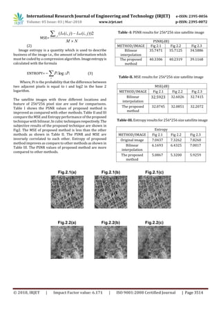
Fig 2. Results (a) original (b) bilinear (c) IDWT
4. CONCLUSION
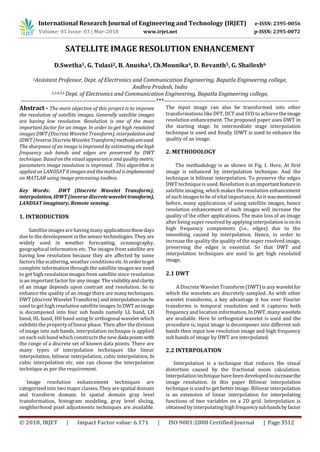
This paper presents the satellite image enhancement
technique based on the interpolation and DWT of high
frequency subbands.The proposedtechniquedecomposesan
low resolution input image into four subband images, and
interpolation is appilied on high frequency sub bandimages.
The interpolation factor of half is applied to the high
frequency subband images as well as input image. The
performance parameters such as PSNR, MSE and ENTROPY
improve as compared to the conventional and state of art
methods. In future this technique can be tested on different
satellite images and fusion of algorithms is also ossible for
further improvements in the result.
REFERENCES
[1] B.D. Jadhav, P.M. Patil, ‘An effective method for satellite
image enhancement”, vol.17, No.4, March 2014.
[2] Parth Bhatt, Ankit Shah, “Image enhancement using
various interpolation methods”,Vol. 2, No.4, August 2012.
[3] Ravi B. Mehta, Richard Sonaliya, “Survey On Satellite
Image Enhancement Techniques”, Vol. 5 (6) 2014, 7411-
7414.
[4] Prachi R Rajarapollu, Vijay R Mankar, “Interpolation
algorithms implementation for image appearance
enhancement”, Vol. 8, Iss ue 2, April - June 2017.
[5] Dr.P.V Nagarjaneyulu, S.Krishna priya ,”Comparision of
image resolution analysis by wzp and decomposition
methods”,vol.1 (2), 2012.
[6] Thorat Ashwini Anil , Katariya S. S,” Image Resolution
Improvement By Using DWT & SWT Transform”, Vol-1
Issue-4 2015.
[7] USGS landsat8 data download [online]
http://landsat.gov/tools_faq.php](https://image.slidesharecdn.com/irjet-v5i3826-190205052959/85/IRJET-Satellite-Image-Resolution-Enhancement-4-320.jpg)

This document summarizes a research paper that proposes a method to enhance the resolution of satellite images using discrete wavelet transform (DWT), interpolation, and inverse discrete wavelet transform (IDWT). Low resolution satellite images are decomposed into subbands using DWT. Bilinear interpolation is applied to each subband to increase resolution. IDWT is then used to combine the subbands into the enhanced, higher resolution output image. The method is tested on LANDSAT 8 images and evaluated using metrics like PSNR, MSE, and entropy. Results show the proposed method improves these metrics over other interpolation techniques, enhancing image quality and resolution.