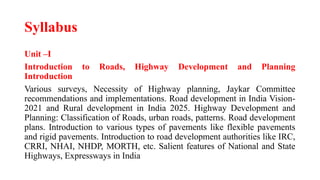
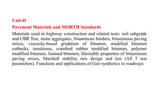
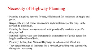
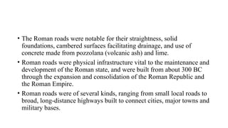
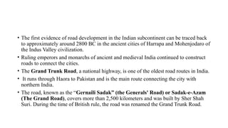
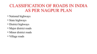
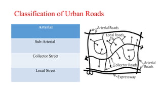
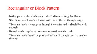
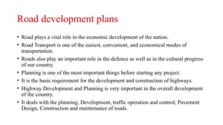
Sanjivani Rural Education Society's
Sanjivani College of Engineering, Kopargaon 423603.
Department of Civil Engineering
Transportation Engineering(CE402)
B Tech Civil, Semester –VIII
Unit-I
By,
Prof. Nitin.B.Aher (ME Env.Engg)(PhD*)
(Assistant Professor)
Mail Id- ahernitincivil@sanjivani.org.in
• Teaching Scheme:
- Lectures: 03 Hrs. / Week
- Credits: 03
• Examination Scheme:
- CIA :40 Marks
- End Sem Exam :60 Marks
- Total :100 Marks.
Course Objectives:
1.To study the necessity of highway planning and classification of roads.
2. To study materials used in highway construction and related tests and
standards.
3. To study the various geometric elements and different cross-sectional
elements of highway
4. To study the design guidelines for flexible and rigid pavement.
5. To study traffic engineering, traffic flow and highway capacity.
6. To study various construction methods and maintenance required for
pavement.
Course Outcomes :
1.Know in detailed about the highway planning, various
types of roads, road patterns and road development in
India.
2.Predict the materials properties and carry out related
tests on the materials used in highway construction as
per standard norms.
3.Use the concept of highway alignment and geometric
design of highway in road designing.
4.Carry out preliminary design of flexible and rigid
pavement as per the site conditions using IRC and
MORTH code.
5.Design and analyze the traffic systems, traffic flow and
decide the traffic capacity on the basis of types of
highway
6.Apply various methods for construction and maintenance
of pavement.
Syllabus
Unit –I
Introduction to Roads, Highway Development and Planning
Introduction
Various surveys, Necessity of Highway planning, Jaykar Committee
recommendations and implementations. Road development in India Vision-
2021 and Rural development in India 2025. Highway Development and
Planning: Classification of Roads, urban roads, patterns. Road development
plans. Introduction to various types of pavements like flexible pavements
and rigid pavements. Introduction to road development authorities like IRC,
CRRI, NHAI, NHDP, MORTH, etc. Salient features of National and State
Highways, Expressways in India
Unit-II
Pavement Materials and MORTH Standards
Materials used in highway construction and related tests: soil subgrade
and CBR Test, stone aggregates, bituminous binders, bituminous paving
mixes, viscosity-based gradation of bitumen, modified bitumen
cutbacks, emulsions, crumbed rubber modified bitumen, polymer
modified bitumen, foamed bitumen, Desirable properties of bituminous
paving mixes, Marshall stability mix design and test (All 5 test
parameters). Functions and applications of Geo-synthetics in roadways
Unit- III
Highway Geometric Design
Introduction, factors controlling design of various geometric elements, different
cross-sectional elements and road margins. Stopping Sight Distance (SSD),
Overtaking Sight Distance (OSD), and overtaking zone, problems. Attainment of
super elevation, radius of curves. Methods of introduction of extra widening,
widening of pavement on horizontal curves, Transition Curves-shape and length of
transition curves, shift of transition curves. Design of vertical alignment, gradient
and its type, IRC recommendations, 06 3 9 grade compensation on horizontal
curve, vertical curves: crest and sag curves, types of summit curves, length of
summit curve for SSD and OSD. Requirements, types of valley curves, length of
valley curve for comfort and head light sight distance criteria. Grade compensation.
Unit IV
Pavement Analysis and Design Flexible pavements
components and functions, computation of design traffic (vehicle
damage factor, lane distribution factor, and traffic growth rate), flexible
pavements, stresses in flexible pavements Rigid pavements: components
and functions, factors affecting design, ESWL, Stresses in rigid
pavements, wheel load stresses and temperature stresses, design
guidelines for concrete pavements as per IRC 58-2015. Joints in CC
pavements, problems, highway drainage: subsurface and surface
drainage.
Unit –V
Traffic Engineering Studies and Analysis Traffic Studies
Volume, Spot Speed, Speed and Delay, Origin and Destination, parking
on street and off-street Parking- space consideration, parking demand,
parking load and duration, space demand relation. Accidents- Causes,
Analysis, Measures to reduce Accident. Categories of traffic flow,
uninterrupted traffic flow model, Analysis of speed, flow and density
relationship. Traffic signs, Types of intersections. Smart signal systems.
Unit VI
Pavement Construction and Maintenance
Investigation of material for highway construction, Construction of
subgrade, subbase, base layers, bituminous courses and MORTH
specifications, routine maintenance, periodic maintenance, special
repairs, responsive maintenance program, reconstruction, and treatment
strategies.
Text Books:
1. Highway engineering – S.K. Khanna, C.E.G. Justo & A. Veeraragavan, Nem Chand and
Brothers,
Roorkee.
2. Traffic Engineering (5th edition), Roger P. Roess , Elena S. Prassas & William R.
McShane.,
Pearson Publication.
3. Principles and practices of Highway engineering –Dr. L.R. Kadiyali, Khanna Publishers
Delhi.
4. Essentials of bridge engineering, Victor D.J., Oxford and IBH publisher, Delhi
5. Railway Engineering Chandra, Satish and Agarwal, M.M. Oxford University Press, New
Delhi
6. Bridge engineering by Rangwala, Charotar Publishing House Pvt Ltd
Reference Books:
1. A Course in Highway Engineering – S.P. Bindra, Dhanpat Rai and Sons,
Delhi.
2. Principles of Transportation Engineering – G.V. Rao Tata MacGraw Hill
Publication
3. Highway Engineering – Rangawala, Charotar publishing House, Anand
388001 (Gujrat)
4. Principles of Transportation Engineering – Partha Chakraborty, Animesh
Das, Prentice Hall
of India Pvt. Ltd., New Delhi.
5. Design of bridges, N.Krishnamraju, Oxford and IBH publisher, Delhi
I.S. Codes:
1. I.S. 1201 TO 1220-1978, IS 73, IS 2386 PART I toV
2. I.R.C. 58, IRC37 3. Specifications for Road and Bridge works (MORTH)-IRC, New Delhi.
Hand Books:
1. Handbook of Road Technology Lay M.G., Gorden Breach Science Pub.Newyork
2. Civil Engineering Handbook-Khanna S.K.
e – Resources:
1.www.nptel.iitm.ac.in/courses/iitkanpur
2. www.cdeep.iitb.ac.in/nptel
Unit -I Introduction
Highway Engineering
• The man always tries to become a superman, as the efforts is to make
the life easier and worth living.
• The development of new ideas and ways is the result of this thinking.
• Highway engineering is an engineering discipline branching from civil
engineering that involves the planning, design, construction,
operation, and maintenance of roads, bridges, and tunnels to ensure
safe and effective transportation of people and goods.
• The role of a highway engineer is to oversee the costing, estimating,
planning and implementation of a project.
Necessity of Highway Planning
• Planning a highway network for safe, efficient and fast movement of people and
goods.
• Keeping the overall cost of construction and maintenance of the roads in the
network to a minimum.
• Planning for future development and anticipated traffic needs for a specific
design period.
• National Highways are very important for transportation of goods across the
lengths and breadths of India.
• Presently, the length of National Highways in India is about 96261 km.
• They spread through all the states like a network, providing road connectivity
throughout the country.
History of Highways in the world
Ancient Roman roads
• The Roman roads were notable for their straightness, solid
foundations, cambered surfaces facilitating drainage, and use of
concrete made from pozzolana (volcanic ash) and lime.
• Roman roads were physical infrastructure vital to the maintenance and
development of the Roman state, and were built from about 300 BC
through the expansion and consolidation of the Roman Republic and
the Roman Empire.
• Roman roads were of several kinds, ranging from small local roads to
broad, long-distance highways built to connect cities, major towns and
military bases.
Ancient roads in India
• The first evidence of road development in the Indian subcontinent can be traced back
to approximately around 2800 BC in the ancient cities of Harrapa and Mohenjodaro of
the Indus Valley civilization.
• Ruling emperors and monarchs of ancient and medieval India continued to construct
roads to connect the cities.
• The Grand Trunk Road, a national highway, is one of the oldest road routes in India.
• It runs through Haora to Pakistan and is the main route connecting the city with
northern India.
• The road, known as the “Gernaili Sadak” (the Generals' Road) or Sadak-e-Azam
(The Grand Road), covers more than 2,500 kilometers and was built by Sher Shah
Suri. During the time of British rule, the road was renamed the Grand Trunk Road.
Mr. M.R. Jayakar, chairman, Road
Development Committee,1927
Jayakar Committee recommendations and
implementations
• The first world war time frame and that promptly tailing it was conceived a quick
development in vehicular transport.
• So requirement for better streets turned into a need.
• For that, the Government of India selected a committee called Road Development
Committee with Mr. M.R. Jayakar as the chairman.
• This committee came to be known as Jayakar committee.
• In 1927 Jayakar committee for Indian road development was appointed.
• The major recommendations were:
1. Committee found that the road development of the country has become beyond the
capacity of local governments and suggested that Central government should take
the proper charge considering it as a matter of national interest.
2. They gave more stress on long term planning program, for a period of
20 years (hence called twenty year plan) that is to formulate plans and
implement those plans with in the next 20years.
3 One of the recommendations was the holding of periodic road
conferences to discuss about road construction and development.
4. The committee suggested imposition of additional taxation on motor
transport which includes duty on motor spirit, vehicle taxation, license
fees for vehicles plying for hire.
5. Research organization should be constituted to carry out research and
development work.
Results of Jayakar Committee
Recommendations
• A development fund called Central road fund was levied on fuels in
1929.
• This fund was intended for road development.
• A semi-official technical body called Indian Road Congress (IRC) was
established in 1934.
• The 20 Year Road development plans were initiated.
• Formation of Central Road Research Institute (CRRI) was done in
1950.
Central Road Fund (CRF):1929
• The Union Government used to allocate funds for development of State Roads to the respective State
Governments under Central Road Fund (CRF) Scheme.
• Central Road Fund Scheme was constituted on 1 March 1929 by setting apart an amount of 2.64
paise per litre out of the Custom & Central Excise Duty levied on petrol for the development of the
State Roads.
• The cess was increased from time to time to meet the challenges of accelerated funding requirement
for all categories of roads in the country.
• Central Road Fund (CRF) is a non-lapsable fund created under Section 6 of the Central Road Fund
Act, 2000 out of a cess/tax imposed by the Union Government on the consumption of Petrol and
High Speed Diesel
• The tax is leived to develop and maintain National Highways, State roads (particularly those of
economic importance and which provides inter state connectivity), rural roads, railway under/over
bridges etc. 
• Around Rs. 20,000 crores get collected under CRF per annum (during the years2012-14).
UTILISATION OF THE CENTRAL
ROAD FUND:
• Development and maintenance of national highways.
• Development of the rural roads.
• Development and maintenance of other State roads including roads of
inter-State and economic importance.
• Construction of roads under or over the railways by means of a bridge
and safety works at unmanned rail-road crossings.
• Disbursement in respect of such projects as may be prescribed by the
Government.
Road development in India
• India has around 1,46,126 of National Highways as of 25July 2024
and is expected to reach 2,00,000 km By end 2024 consisting of Top
Notch Highways And Expressways.
• National Highways constituted 2.7% of India's total road network, but
carried about 40% of road traffic, as of 2013.
• Road transport in modern sense i.e. vehicles driven by internal
combustion engines using petrol or diesel as fuel was practically
negligible in India before World War II.
• Following plans have been drawn to develop roadways in India.
1. Nagpur Plan:
• First serious attempt to develop roadways was made in 1943 when
Nagpur Plan was drawn.
• This plan envisaged increasing of the kilometre age of major roads to
1, 96,800 km and of other roads to 3, 32,800 km by 1953.
• The highlight of the plan was that no village in a developed
agricultural region should be more than 8 km from a major road or 3
km away from any other road while the average distance of villages
from a major road should be less than 3.2 km.
• In a non- agricultural region, these distances were fixed at 32, 8 and 10
km respectively.
• This plan could not be implemented immediately because the country
was ruled by a number of princely states outside British India.
• The concerted efforts to achieve the objectives of this plan were made
only after the re-organisation of the states.
• The targets of this plan were more or less achieved by 1961.
2. The Twenty Year Plan:
• After achieving the objectives of the Nagpur Plan, another plan known as Twenty Year
Road Plan was drawn in 1961.
• It aimed at increasing the road length from 6.56 lakh km to 10.60 lakh km and the
density to 32 km of road per 100 sq km by 1981.
• The other objectives of the Twenty Year Road Plan were
(i) to bring every village in a developed agricultural area within 6.4
km of a metalled road and 2.4 km of any other road,
(ii) to bring every village in a semi-developed area within 12.8 km of a
metalled road and
(iii) to bring every village in an undeveloped and uncultivated area within 19.2
km of a metalled road and 8 km of any other road.
• 3. The Rural Development Plan includes construction of rural roads
under Minimum Needs Programme (MNP), Rural Landless
Employment Guarantee Programme (RLEGP), Jawahar Rojgar Yojana
(JRY) and Command Area Development (CAD) programmes to
connect all villages having a population of 1,500 or more with all
weather roads and those having less than 1,500 population with a link
roads.
• 4. Build Operate Transfer (ВОТ) is a scheme under which private
operators are invited to construct roads and bridges.
• They are allowed to collect toll tax from the vehicles using these roads
and bridges for a specific period of time after which these assets are
transferred to the government.
• The National Highways Act has been amended to facilitate private
investment in real construction under ВОТ scheme.
• The share of national highways increased slightly after 1991 and stood
at 1.90 per cent in 1999.
• The share of panchayat raj roads so fell from 51.61 per cent in 1951 to
37.60 per cent in 1961 and rose gradually to 47.09 per cent in 1991.
However, it fell to 40.71 per cent in 1999.
• Currently Indian roads carry 85 per cent of the passenger and 70 per
cent of the freight traffic of the country.
Road Development Plan Vision: 2021
• The Government of India takes up the development works of National Highways through
five year plans.
• However, the Ministry in 2001 had prepared, through Indian Roads Congress (IRC), `Road
Development Plan VISION: 2021’ for a period of 20 years (2001-2021).
• This document provided the vision for the next 20 years for development and maintenance
of all categories of roads i.e. National Highways, State Highways, Major District Roads and
Rural Roads.
• The urban roads as well as the roads for specific need e.g. tourism, forestry, mining and
industrial areas etc. have also been considered.
• The research and development, mobilisation of resources, capacity building and human
resources development, quality system, environment and energy considerations for the
highway sector and highway safety are also included in this document which serves as only
a valuable guide to the Centre and the State Governments for planning purpose.
RURAL ROAD DEVELOPMENT PLAN :
VISION 2025
• The `RURAL ROAD DEVELOPMENT PLAN : VISION 2025’ was
released on 27 May 2007 by the Prime Minister, Dr. Manmohan
Singh during the inaugural session of the two-day National
Conference on Rural Roads organized by the organized by the
National Rural Roads Development Agency (NRRDA), an
autonomous agency under the Ministry of Rural Development and the
Construction Industry Development Council (CIDC).
Some of the salient features of the Plan
• In order to give a boost to rural connectivity, a Rural Roads Programme
known as the Pradhan Mantri Gram Sadak Yojana (PMGSY) was launched
in December 2000 as a 100 percent centrally funded scheme.
• It is estimated that about 1.79 lakh unconnected habitations need to be taken
up under the PMGSY programe till 2007.
• This would involve new construction in a length of about 375,000 km at an
estimated cost of Rs. 78,000 crore and improvements of 372,000 km at an
estimated cost of Rs. 59,000 crore.
• Upto the end of December, 2006, a total of about 83,000 habitations have
been covered and rural road works for an amount of Rs.38,387 crore have
been sanctioned.
• Besides the balance work of PMGSY which in itself is an ambitions
task, there is need to tackle the requirement of connectivity to
habitations with lower population in the interest of social justice and
removing sense of isolation of remote villages and bring them into
main stream of national life.
• The objective has to be to provide full connectivity to all habitations
including provision of bridges and culverts. Accordingly, the
following vision for new connectivity has been recommended.
• The state governments may use the District Rural Roads Plan and the
Core Network developed as part of the PMGSY programme for a
holistic planning and implementation of their state level programmes
as well.
• Rural roads do require proper engineering and design with special
attention on drainage and protection works. The design standards,
however, should be in harmony with the requirement of rural roads
serving the access function. It is preferable to optimize costs by stage
construction in tune with traffic growth.
• Road safety should receive increasing attention in planning, design and
implementation of engineering measures on rural roads.
• The engineering measures should preferably be identified with the help of traffic and
safety specialist.
• The Government also needs to develop independent think-tanks and academicians on
various aspects of rural roads like engineering, safety, environmental issues, socio-
economic impact, etc.
• They may fund positions in institutions like NCAER(National Council of Applied
Economic Research), IIPA(Indian Institute of Public administration), IIMs, IITs and
NITs.
• Action should be taken by each state to formulate a 5-year Action Plan in the light of
recommendations of the Vision document.
Summary of the planned road periods
• The investments in highways and bridges was extremly
attractive,sometimes more attractive than irrigation scheme.
• As soon as the roads was constructed there was increase in the traffic
which was leading to motar tax,insurance and motar cess etc.
• On other hand the tax collection in irrigation dept. was very low.
• It has been estimated that investment of Rs. 8300/- crores was taking
up the scheme of certain expressway ,foue lanning and strenthening of
existing National highways.
Highway Development and planning
• Planning a highway network for safe, efficient and fast movement of
people and goods.
• Keeping the overall cost of construction and maintenance of the roads in
the network to a minimum.
• Planning for future development and anticipated traffic needs for a specific
design period.
• Phasing road development programmes from considerations of utility and
importance as also of financial resources.
• Evolving a financing system compatible with the cost and benefits.
CLASSIFICATION OF ROADS IN INDIA
AS PER NAGPUR PLAN
• National highways
• State highways
• District highways
• Major district roads
• Minor district roads
• Village roads
NEED OF CLASSIFYING ROADS:-
• To plan a road network for efficient and safe traffic operation .
• knowing the clear information of a particular root in a country.
• The classification of roads was necessary.
• To decide the road patterns.
• To connect to the roads to every part of country.
NATIONAL HIGHWAYS
• These are the important roads of
the country.
• They connect state capitals, ports
and foreign highways. They also
include roads of military
importance.
• They are financed by the central
government.
STATE HIGHWAYS
• These are the important roads of a
state.
• Theyconnect important cities and
district head quarters in the state ,
national highways & state
highways of neighbouring states.
• They are financed by state
government roads and buildings
department of the state government
constructs & maintain these roads
DISTRICT ROADS
• These are the roads within a
district .
• They are financed by
zillaparishads with the help of
grants given by state
government.
THE MAJOR DISTRICT ROADS
• They are roads connecting
district head quarters, taluka
head quarters and other
important town in the district
production and market centers
with each other and with state ,
national highways & railways.
OTHER DISTRICT ROADS AND
VILLAGE ROADS.
• They are district roads of less
importance.
• VILLAGE ROADS -they
connect villages with each other
and to the nearest district road.
They are financed by panchayats
with the help of zilla parishads
and state government.
INDIAN ROAD CLASSIFICATION BASED ON
INDIA ROADS CONGRESS
Non Urban roads Urban roads Rural roads
Expressway Arterial Other District Roads
National Highways Sub-Arterial Village Roads
State Highways Collector Street
Major District Roads Local Street
Classification of Urban Roads
Arterial
Sub-Arterial
Collector Street
Local Street
• EXPRESSWAYS
• The city roads which are reserved for motor traffic with full or partial
control access and are provided with grade separation at intersections are
called expressways.
• These are generally constructed to have direct connection between major
points of traffic generation in industrial or commercial or business districts.
• Along expressways, the motor traffic attains very high speeds.
• Neither the loading nor unloading of the goods is permitted on these
expressways.
• Pedestrians too cannot cross the expressways.
• ARTERIAL STREETS
• The city roads which are meant for through traffic usually on a
continuous route are called arterial streets.
• Arterial streets are generally spaced at less than 15 km in developed
business centres whereas in less important areas, these may be 8 km apart.
• Arterial roads are also divided highways with fully or partially controlled
access.
• Parking, loading and unloading are carefully regulated.
• Pedestrians are permitted to cross them at intersection only.
• SUB-ARTERIAL STREETS
• The city roads which provided lower level of travel mobility than
arterial streets, are called sub-arterial streets.
• Their spacing may vary from 0.5 km in central business districts to 3
to 5 km in sub-urban areas.
• Loading and unloading are usually restricted.
• Pedestrians are allowed to cross these highways at intersections.
• COLLECTOR STREETS
• The city roads which are constructed for collecting and distributing the
traffic to and from local streets, and also to provide an access to
arterial and sub-arterial streets, are called collector streets.
• These are located in residential, business and industrial areas.
• These roads are accessible from the buildings along them.
• Parking restrictions are few and that too during peak hours.
• LOCAL STREETS
• The city roads which provide an access to residence, business and
other buildings, are called local streets. The traffic carried either
originates or terminates along the local streets.
• Depending upon the important of the adjoining areas, a local street
may be residential, commercial or industrial.
• Along local streets pedestrians may move freely and parking may be
permitted without any restriction.
The website of the national highways authority
of India (NHAI) (link) gives the classes as
• Expressways
• National highways
• State highways
• Major district roads
• Rural and other roads
Introduction of Road Pattern
• Roadway patterns are very essential in the development of the settlements of a city.
• The recent development in cities does not give importance to the study of the road
patterns that give rise to numerous roads that are not interconnected, housing
schemes and commercial developments built far away from where roads are very
distant from the centre of the town.
• The increasing distance between the residential and commercial hub of the city
increases the dependency upon cars for the daily travel chores each household
member makes frequently.
• When the road is constructed in patterns like rectangular, radial, hexagonal, etc for
the proper management of traffic and also to interconnect the branch roads with
main roads then it is called road pattern.
Road patterns
1. Rectangular or Block Pattern
2. Radial or Star and Block Pattern
3. Radial or Star and Circular Pattern
4. Radial or Star and Grid Pattern
5. Hexagonal Pattern
6. Minimum Travel Pattern
Rectangular or Block Pattern
• In this pattern; the whole area is divided into rectangular blocks.
• Streets or branch roads intersect with each other at the right angle.
• The main roads always pass through the centre and it should be wide
enough.
• Branch roads may be narrow as compared to main roads.
• The main roads should be provided with a direct approach to outside
the city.
2. Radial or Star and Block Pattern
• It is a combination of star and
block patterns.
• The entire area is divided into a
radial network of roads radiating
from the centre outwardly with a
block pattern network of roads in
between the radial main streets.
3. Radial or Star and Circular Pattern
• It is the pattern in which the
main roads(radial roads) radiates
from the central point and are
connected with concentric
roads(ring roads) that are also
radiating outwardly.
4. Radial or Star and Grid Pattern
• This pattern is formed by the
combination of Star and Grid
Pattern.
• As in other, a radial network of
road radiates from the centre
outwardly. Then, the main radial
streets are interconnected by
providing a grid pattern.
Road development plans
• Road plays a vital role in the economic development of the nation.
• Road Transport is one of the easiest, convenient, and economical modes of
transportation.
• Roads also play an important role in the defence as well as in the cultural progress
of our country.
• Planning is one of the most important things before starting any project.
• It is the basic requirement for the development and construction of highways.
• Highway Development and Planning is very important in the overall development
of the country.
• It deals with the planning, Development, traffic operation and control, Pavement
Design, Construction and maintenance of roads.
Introduction to various types of pavements
• There are two types of pavements based on design considerations i.e.
1.Flexible pavement
2.Rigid pavement.
• Difference between flexible and rigid pavements is based on the
manner in which the loads are distributed to the subgrade
• A highway pavement is a structure consisting of superimposed layers of processed
materials above the natural soil sub-grade, whose primary function is to distribute the
applied vehicle loads to the sub-grade.
• The pavement structure should be able to provide a surface of acceptable riding quality,
adequate skid resistance, favorable light reflecting characteristics, and low noise pollution.
• The ultimate aim is to ensure that the transmitted stresses due to wheel load are
sufficiently reduced, so that they will not exceed bearing capacity of the sub-grade.
• Two types of pavements are generally recognized as serving this purpose, namely flexible
pavements and rigid pavements. This chapter gives an overview of pavement types, layers,
and their functions, and pavement failures.
• Improper design of pavements leads to early failure of pavements affecting the riding
quality
Requirements of a pavements
• Sufficient thickness to distribute the wheel load stresses to a safe value on
the sub-grade soil.
• Structurally strong to withstand all types of stresses imposed upon it.
• Adequate coefficient of friction to prevent skidding of vehicles.
• Smooth surface to provide comfort to road users even at high speed.
• Produce least noise from moving vehicles.
• Dust proof surface so that traffic safety is not impaired by reducing visibility.
• Impervious surface, so that sub-grade soil is well protected, and
long design life with low maintenance cost.
Flexible pavements
• Flexible pavements will transmit wheel
load stresses to the lower layers by
grain-to-grain transfer through the points
of contact in the granular structure
• The wheel load acting on the pavement
will be distributed to a wider area, and
the stress decreases with the depth. .
• Taking advantage of this stress
distribution characteristic, flexible
pavements normally has many layers.
Hence, the design of flexible pavement
uses the concept of layered system.
Types of Flexible Pavements
• Conventional flexible pavements are layered systems with high quality
expensive materials are placed in the top where stresses are high, and low
quality cheap materials are placed in lower layers.
• Full - depth asphalt pavements are constructed by placing bituminous
layers directly on the soil sub-grade. This is more suitable when there is
high traffic and local materials are not available.
• Contained rock asphalt mats are constructed by placing dense/open graded
aggregate layers in between two asphalt layers. Modified dense graded
asphalt concrete is placed above the sub-grade will significantly reduce
the vertical compressive strain on soil sub-grade and protect from surface
water.
Failure of flexible pavements
• The major flexible pavement failures are fatigue cracking, rutting, and
thermal cracking.
• The fatigue cracking of flexible pavement is due to horizontal tensile
strain at the bottom of the asphaltic concrete.
• Rutting occurs only on flexible pavements as indicated by permanent
deformation or rut depth along wheel load path.
• Thermal cracking includes both low-temperature cracking and thermal
fatigue cracking.
Rigid Pavement
• Rigid pavements have sufficient flexural strength to transmit the wheel
load stresses to a wider area below.
• Compared to flexible pavement, rigid pavements are placed either
directly on the prepared sub-grade or on a single layer of granular or
stabilized material.
• Since there is only one layer of material between the concrete and the
sub-grade, this layer can be called as base or sub-base course.
• In rigid pavement, load is distributed by the slab action, and the
pavement behaves like an elastic plate resting on a viscous medium
Types of Rigid Pavements
• Jointed Plain Concrete Pavement:are plain cement concrete pavements
constructed with closely spaced contraction joints. Dowel bars or aggregate
interlocks are normally used for load transfer across joints. They normally has
a joint spacing of 5 to 10m.Tie bars are generally provided across longitudinal
joints of cement concrete pavements fot interlocking of aggregate.
• Jointed Reinforced Concrete Pavement:Although reinforcements do not
improve the structural capacity significantly, they can drastically increase the
joint spacing to 10 to 30m. Dowel bars are required for load transfer.
Reinforcements help to keep the slab together even after cracks.
• Continuous Reinforced Concrete Pavement:Complete elimination of joints are
achieved by reinforcement.
Failure criteria of rigid pavements
• Traditionally fatigue cracking has been considered as the major, or
only criterion for rigid pavement design.
• The allowable number of load repetitions to cause fatigue cracking
depends on the stress ratio between flexural tensile stress and concrete
modulus of rupture.
• Pumping is the ejection of soil slurry through the joints and cracks of
cement concrete pavement, caused during the downward movement of
slab under the heavy wheel loads.
• Other major types of distress in rigid pavements include faulting,
warping stress due to daily variation in temp.spalling, and deterioration
Summary of Pavements
• Pavements are form the basic supporting structure in highway
transportation.
• Each layer of pavement has a multitude of functions to perform which
has to be duly considered during the design process.
• Different types of pavements can be adopted depending upon the
traffic requirements.
• Improper design of pavements leads to early failure of pavements
affecting the riding quality also
Consider the following statements in the context of cement concrete
pavements.(Gate 2009, 2 M)
1. Warping stresses in cement concrete pavements are caused by the seasonal
variation in temperature,
2. Tie bars are generally provided across transverse joints of cement concrete
pavements
The correct option evaluating the above statements is
1: True and 2: False
1: False and 2: True
1: True and 2: True
1: False and 2: False
SOLUTION
correct answer is 1: False and 2: False
• Warping stress in cement concrete pavements are caused by the daily
variation in temperature
• Tie bars are generally provided across longitudinal joints of cement
concrete pavements.
PradhanMantri Gram SadakYojna (PMGSY), launched in the year 2000,
aims to provide rural connectivity with allweather roads. It was
proposed to connect the habitations in plain areas of population more
than 500 persons by the year.(Gate 2005 2 marks)
• 2005
• 2007
• 2010
• 2012
• Ans Option B 2007.
It is estimated that about 1.79 lakh unconnected habitations need to be
taken up under the PMGSY programe till 2007.
Introduction to road development authorities
like IRC
• The Indian Road Congress was formed as the apex body for
Engineering in Highway construction in India in the year 1934 with 73
members with the main objective for development of roads and
helping to provides a stage for exchanging expertise and latest
research developments relating to it are shared.
• In more specific terms, the objectives of the IRC are: to promote and
encourage the science and practice of building, operation and
maintenance of roads.
• To provide a channel for the expression of collective opinion of its
members regarding roads.
Functions of IRC
• To promote the use of standard specifications and practices.
• To suggest improved method of planning ,design
construction,maintenance and administration of roads.
• To conduct periodical meetings to discuss technical questions
regarding roads.
• To make laws for development , improvement and protection of roads
Introduction to CRRI(Central Research Road
Institute)
• To carry out basic and applied research, in line with the national priorities for
investigation, construction and maintenance of different types of roads and
runway, including related material such as aggregates, bitumen, cement, etc.
• To nurture scientific talent for development of safe and sustainable
transportation system.
• To be a renowned knowledge generator and repository for innovative
technological and inclusive solutions in the areas of roads and multi-modal
transport system.
• To benchmark internationally the product portfolio of the Institute.
• To provide an effective R&D platform for close interactions with stakeholders
in the area of road transportation sector.
Key Objectives of CRRI
• To develop specifications, labor intensive methods and manual aids for construction
of low cost, all weather village roads for under developed regions of the country.
• To carry out basic and applied research, in line with the national priorities for
investigation, construction and maintenance of different types of roads and runway,
including related material such as aggregates, bitumen, cement, etc.
• To develop appropriate tools, machinery, equipment and instruments for adopting
technologies as related to highway engineering and relevant to the country to achieve
indigenous self-sufficiency.
• To carry out research on the performance of different types of roads under varying
climatic and traffic conditions.
• To carry out research on utilisation of locally available materials for construction and
maintenance or roads & runways economically.
Introduction to NHAI (National Highway
Authority of India)
• National Highways Authority of India (NHAI) was constituted by an Act of
Parliament in 1988 under the administrative control of the Ministry of
Road Transport and Highways
• NHAI has been set up as a Central Authority to develop, maintain and
manage the National Highways entrusted to it by the Government of India.
• NHAI enters into Concession Agreements for design, construction,
operation and maintenance of highways.
• Government of India has appointed senior IAS officer Santosh Kumar
Yadav as the chairman of the National Highways Authority of India
(NHAI) on 26 December 2022.
Introduction to NHDP
• The National Highways Development Project (NHDP) is a project to upgrade,
rehabilitate and widen major highways in India to a higher standard. The project was
started in 1998 under the leadership of Prime Minister, Atal Bihari Vajpayee.
• The National Highways Development project aims to expand the extent of highways
in our country. It also aims to provide quality roads and ease transportation via these
national highways.
• The NHDP aims to improve and enhance connectivity and reduce the existing traffic
• NHDP Phase I which was approved by Cabinet Committee on Economic Affairs
(CCEA) in December 2000 at an estimated cost of Rs. 30,300 crore (1999 prices)
comprises 5,846 km of Golden Quadrilateral, 981 km of NS-EW corridors, 380 km
of Port Connectivity and 315 km of other National Highways, a total of 7,522 km.
Introduction to MORTH
• The Ministry of Road Transport and Highways (MoRTH) is a ministry of the
Government of India, that is the apex body for formulation and
administration of the rules, regulations and laws relating to road transport,
transport research and in also to increase the mobility and efficiency of the
road transport system.
• Provide and manage a safe national road network (primary avenues of
mobility) to enable and contribute to economic growth and social
development.
• Utilise the primary road network system to spatially transform the roads
(integrated cities, accessible resources, services, facilities and locations)
• General (Dr.) V.K. Singh is the chairman of MORTH.
Salient features of National Highways
• The National Highways help in interstate transport.
• These National Highways are constructed and maintained by the Central
Government.
• National Highway Authority of India is responsible for the maintenance and
development of the National Highways.
• They spread through every one of the states like an organization, giving street
availability all through the country.
• National Highways form only 2.91% of the total length of roadways in India.
• They help to transport about 40% of the total transport plying through
roadways in the country.
National Highway Case study NH 1
• National Highway 1 in India runs between the union territories of Jammu &
Kashmir and Ladakh.
• It comprises parts of old NH1A and NH1D. The number 1 indicates, under the
new numbering system, that it is the northernmost East-West highway in India.
• Length: 534 km
• Highway system: Indian National Highway System
• East end: NH 3, Leh
• West end: S-3 Strategic Highway, Hattian Bala
• National Highway 1 is also known as Shershah Suri marg,Shershah Suri was
the founder of the Suri Empire.
Salient features of StateHighways
• The state highways are usually roads that link important cities, towns and district
headquarters within the state and connect them with National Highways or state
highways of neighbouring states.
• State highways are the highways which connect the state capital with all the major
district headquarters and important towns of the state.
• The state highways are maintained and administered by the state government
(Public Works Department).
• State Highway 10, commonly referred to as MH SH 10, is a normal state highway
that runs south through Pune, Ahmednagar, Nashik and Dhule districts in the state
of Maharashtra, India. This state highway touches the cities of Dondaicha,
Shevade, Mehergaon, Kusumbe, Malegaon, Manmad, Yeola, Kopargaon, Shirdi
Rahata, Rahuri, Ahmednagar, Kashti, and Daund.
Salient features of Expressway
• Expressway, also called throughway, thruway, parkway, freeway,
superhighway, or motorway, major arterial divided highway that features two
or more traffic lanes in each direction, with opposing traffic separated by a
median strip; elimination of grade crossings; controlled entries and exits.
• Expressways are the highest class roads in India.
• These are the highways with six to eight lane controlled access road network.
• Basically, expressways are of high quality consisting of modern features like
access ramps, grade separation, lane dividers and elevated section.
• Mumbai-Nagpur-expressway (Samruddhi Mahamarg)
Check for CO
Know in detailed about the highway planning, various types of
roads, road patterns and road development in India.
End of Unit -I
Thank You

Introduction to Transportation Engineering

  • 1.
    Sanjivani Rural EducationSociety's Sanjivani College of Engineering, Kopargaon 423603. Department of Civil Engineering Transportation Engineering(CE402) B Tech Civil, Semester –VIII Unit-I By, Prof. Nitin.B.Aher (ME Env.Engg)(PhD*) (Assistant Professor) Mail Id- ahernitincivil@sanjivani.org.in
  • 2.
    • Teaching Scheme: -Lectures: 03 Hrs. / Week - Credits: 03 • Examination Scheme: - CIA :40 Marks - End Sem Exam :60 Marks - Total :100 Marks.
  • 3.
    Course Objectives: 1.To studythe necessity of highway planning and classification of roads. 2. To study materials used in highway construction and related tests and standards. 3. To study the various geometric elements and different cross-sectional elements of highway 4. To study the design guidelines for flexible and rigid pavement. 5. To study traffic engineering, traffic flow and highway capacity. 6. To study various construction methods and maintenance required for pavement.
  • 4.
    Course Outcomes : 1.Knowin detailed about the highway planning, various types of roads, road patterns and road development in India. 2.Predict the materials properties and carry out related tests on the materials used in highway construction as per standard norms. 3.Use the concept of highway alignment and geometric design of highway in road designing.
  • 5.
    4.Carry out preliminarydesign of flexible and rigid pavement as per the site conditions using IRC and MORTH code. 5.Design and analyze the traffic systems, traffic flow and decide the traffic capacity on the basis of types of highway 6.Apply various methods for construction and maintenance of pavement.
  • 6.
    Syllabus Unit –I Introduction toRoads, Highway Development and Planning Introduction Various surveys, Necessity of Highway planning, Jaykar Committee recommendations and implementations. Road development in India Vision- 2021 and Rural development in India 2025. Highway Development and Planning: Classification of Roads, urban roads, patterns. Road development plans. Introduction to various types of pavements like flexible pavements and rigid pavements. Introduction to road development authorities like IRC, CRRI, NHAI, NHDP, MORTH, etc. Salient features of National and State Highways, Expressways in India
  • 7.
    Unit-II Pavement Materials andMORTH Standards Materials used in highway construction and related tests: soil subgrade and CBR Test, stone aggregates, bituminous binders, bituminous paving mixes, viscosity-based gradation of bitumen, modified bitumen cutbacks, emulsions, crumbed rubber modified bitumen, polymer modified bitumen, foamed bitumen, Desirable properties of bituminous paving mixes, Marshall stability mix design and test (All 5 test parameters). Functions and applications of Geo-synthetics in roadways
  • 8.
    Unit- III Highway GeometricDesign Introduction, factors controlling design of various geometric elements, different cross-sectional elements and road margins. Stopping Sight Distance (SSD), Overtaking Sight Distance (OSD), and overtaking zone, problems. Attainment of super elevation, radius of curves. Methods of introduction of extra widening, widening of pavement on horizontal curves, Transition Curves-shape and length of transition curves, shift of transition curves. Design of vertical alignment, gradient and its type, IRC recommendations, 06 3 9 grade compensation on horizontal curve, vertical curves: crest and sag curves, types of summit curves, length of summit curve for SSD and OSD. Requirements, types of valley curves, length of valley curve for comfort and head light sight distance criteria. Grade compensation.
  • 9.
    Unit IV Pavement Analysisand Design Flexible pavements components and functions, computation of design traffic (vehicle damage factor, lane distribution factor, and traffic growth rate), flexible pavements, stresses in flexible pavements Rigid pavements: components and functions, factors affecting design, ESWL, Stresses in rigid pavements, wheel load stresses and temperature stresses, design guidelines for concrete pavements as per IRC 58-2015. Joints in CC pavements, problems, highway drainage: subsurface and surface drainage.
  • 10.
    Unit –V Traffic EngineeringStudies and Analysis Traffic Studies Volume, Spot Speed, Speed and Delay, Origin and Destination, parking on street and off-street Parking- space consideration, parking demand, parking load and duration, space demand relation. Accidents- Causes, Analysis, Measures to reduce Accident. Categories of traffic flow, uninterrupted traffic flow model, Analysis of speed, flow and density relationship. Traffic signs, Types of intersections. Smart signal systems.
  • 11.
    Unit VI Pavement Constructionand Maintenance Investigation of material for highway construction, Construction of subgrade, subbase, base layers, bituminous courses and MORTH specifications, routine maintenance, periodic maintenance, special repairs, responsive maintenance program, reconstruction, and treatment strategies.
  • 12.
    Text Books: 1. Highwayengineering – S.K. Khanna, C.E.G. Justo & A. Veeraragavan, Nem Chand and Brothers, Roorkee. 2. Traffic Engineering (5th edition), Roger P. Roess , Elena S. Prassas & William R. McShane., Pearson Publication. 3. Principles and practices of Highway engineering –Dr. L.R. Kadiyali, Khanna Publishers Delhi. 4. Essentials of bridge engineering, Victor D.J., Oxford and IBH publisher, Delhi 5. Railway Engineering Chandra, Satish and Agarwal, M.M. Oxford University Press, New Delhi 6. Bridge engineering by Rangwala, Charotar Publishing House Pvt Ltd
  • 13.
    Reference Books: 1. ACourse in Highway Engineering – S.P. Bindra, Dhanpat Rai and Sons, Delhi. 2. Principles of Transportation Engineering – G.V. Rao Tata MacGraw Hill Publication 3. Highway Engineering – Rangawala, Charotar publishing House, Anand 388001 (Gujrat) 4. Principles of Transportation Engineering – Partha Chakraborty, Animesh Das, Prentice Hall of India Pvt. Ltd., New Delhi. 5. Design of bridges, N.Krishnamraju, Oxford and IBH publisher, Delhi
  • 14.
    I.S. Codes: 1. I.S.1201 TO 1220-1978, IS 73, IS 2386 PART I toV 2. I.R.C. 58, IRC37 3. Specifications for Road and Bridge works (MORTH)-IRC, New Delhi. Hand Books: 1. Handbook of Road Technology Lay M.G., Gorden Breach Science Pub.Newyork 2. Civil Engineering Handbook-Khanna S.K. e – Resources: 1.www.nptel.iitm.ac.in/courses/iitkanpur 2. www.cdeep.iitb.ac.in/nptel
  • 15.
  • 16.
    Highway Engineering • Theman always tries to become a superman, as the efforts is to make the life easier and worth living. • The development of new ideas and ways is the result of this thinking. • Highway engineering is an engineering discipline branching from civil engineering that involves the planning, design, construction, operation, and maintenance of roads, bridges, and tunnels to ensure safe and effective transportation of people and goods. • The role of a highway engineer is to oversee the costing, estimating, planning and implementation of a project.
  • 17.
    Necessity of HighwayPlanning • Planning a highway network for safe, efficient and fast movement of people and goods. • Keeping the overall cost of construction and maintenance of the roads in the network to a minimum. • Planning for future development and anticipated traffic needs for a specific design period. • National Highways are very important for transportation of goods across the lengths and breadths of India. • Presently, the length of National Highways in India is about 96261 km. • They spread through all the states like a network, providing road connectivity throughout the country.
  • 18.
    History of Highwaysin the world
  • 19.
  • 20.
    • The Romanroads were notable for their straightness, solid foundations, cambered surfaces facilitating drainage, and use of concrete made from pozzolana (volcanic ash) and lime. • Roman roads were physical infrastructure vital to the maintenance and development of the Roman state, and were built from about 300 BC through the expansion and consolidation of the Roman Republic and the Roman Empire. • Roman roads were of several kinds, ranging from small local roads to broad, long-distance highways built to connect cities, major towns and military bases.
  • 21.
  • 22.
    • The firstevidence of road development in the Indian subcontinent can be traced back to approximately around 2800 BC in the ancient cities of Harrapa and Mohenjodaro of the Indus Valley civilization. • Ruling emperors and monarchs of ancient and medieval India continued to construct roads to connect the cities. • The Grand Trunk Road, a national highway, is one of the oldest road routes in India. • It runs through Haora to Pakistan and is the main route connecting the city with northern India. • The road, known as the “Gernaili Sadak” (the Generals' Road) or Sadak-e-Azam (The Grand Road), covers more than 2,500 kilometers and was built by Sher Shah Suri. During the time of British rule, the road was renamed the Grand Trunk Road.
  • 23.
    Mr. M.R. Jayakar,chairman, Road Development Committee,1927
  • 24.
    Jayakar Committee recommendationsand implementations • The first world war time frame and that promptly tailing it was conceived a quick development in vehicular transport. • So requirement for better streets turned into a need. • For that, the Government of India selected a committee called Road Development Committee with Mr. M.R. Jayakar as the chairman. • This committee came to be known as Jayakar committee. • In 1927 Jayakar committee for Indian road development was appointed. • The major recommendations were: 1. Committee found that the road development of the country has become beyond the capacity of local governments and suggested that Central government should take the proper charge considering it as a matter of national interest.
  • 25.
    2. They gavemore stress on long term planning program, for a period of 20 years (hence called twenty year plan) that is to formulate plans and implement those plans with in the next 20years. 3 One of the recommendations was the holding of periodic road conferences to discuss about road construction and development. 4. The committee suggested imposition of additional taxation on motor transport which includes duty on motor spirit, vehicle taxation, license fees for vehicles plying for hire. 5. Research organization should be constituted to carry out research and development work.
  • 26.
    Results of JayakarCommittee Recommendations • A development fund called Central road fund was levied on fuels in 1929. • This fund was intended for road development. • A semi-official technical body called Indian Road Congress (IRC) was established in 1934. • The 20 Year Road development plans were initiated. • Formation of Central Road Research Institute (CRRI) was done in 1950.
  • 27.
    Central Road Fund(CRF):1929 • The Union Government used to allocate funds for development of State Roads to the respective State Governments under Central Road Fund (CRF) Scheme. • Central Road Fund Scheme was constituted on 1 March 1929 by setting apart an amount of 2.64 paise per litre out of the Custom & Central Excise Duty levied on petrol for the development of the State Roads. • The cess was increased from time to time to meet the challenges of accelerated funding requirement for all categories of roads in the country. • Central Road Fund (CRF) is a non-lapsable fund created under Section 6 of the Central Road Fund Act, 2000 out of a cess/tax imposed by the Union Government on the consumption of Petrol and High Speed Diesel • The tax is leived to develop and maintain National Highways, State roads (particularly those of economic importance and which provides inter state connectivity), rural roads, railway under/over bridges etc.  • Around Rs. 20,000 crores get collected under CRF per annum (during the years2012-14).
  • 28.
    UTILISATION OF THECENTRAL ROAD FUND: • Development and maintenance of national highways. • Development of the rural roads. • Development and maintenance of other State roads including roads of inter-State and economic importance. • Construction of roads under or over the railways by means of a bridge and safety works at unmanned rail-road crossings. • Disbursement in respect of such projects as may be prescribed by the Government.
  • 29.
    Road development inIndia • India has around 1,46,126 of National Highways as of 25July 2024 and is expected to reach 2,00,000 km By end 2024 consisting of Top Notch Highways And Expressways. • National Highways constituted 2.7% of India's total road network, but carried about 40% of road traffic, as of 2013. • Road transport in modern sense i.e. vehicles driven by internal combustion engines using petrol or diesel as fuel was practically negligible in India before World War II. • Following plans have been drawn to develop roadways in India.
  • 31.
    1. Nagpur Plan: •First serious attempt to develop roadways was made in 1943 when Nagpur Plan was drawn. • This plan envisaged increasing of the kilometre age of major roads to 1, 96,800 km and of other roads to 3, 32,800 km by 1953. • The highlight of the plan was that no village in a developed agricultural region should be more than 8 km from a major road or 3 km away from any other road while the average distance of villages from a major road should be less than 3.2 km.
  • 32.
    • In anon- agricultural region, these distances were fixed at 32, 8 and 10 km respectively. • This plan could not be implemented immediately because the country was ruled by a number of princely states outside British India. • The concerted efforts to achieve the objectives of this plan were made only after the re-organisation of the states. • The targets of this plan were more or less achieved by 1961.
  • 33.
    2. The TwentyYear Plan: • After achieving the objectives of the Nagpur Plan, another plan known as Twenty Year Road Plan was drawn in 1961. • It aimed at increasing the road length from 6.56 lakh km to 10.60 lakh km and the density to 32 km of road per 100 sq km by 1981. • The other objectives of the Twenty Year Road Plan were (i) to bring every village in a developed agricultural area within 6.4 km of a metalled road and 2.4 km of any other road, (ii) to bring every village in a semi-developed area within 12.8 km of a metalled road and (iii) to bring every village in an undeveloped and uncultivated area within 19.2 km of a metalled road and 8 km of any other road.
  • 34.
    • 3. TheRural Development Plan includes construction of rural roads under Minimum Needs Programme (MNP), Rural Landless Employment Guarantee Programme (RLEGP), Jawahar Rojgar Yojana (JRY) and Command Area Development (CAD) programmes to connect all villages having a population of 1,500 or more with all weather roads and those having less than 1,500 population with a link roads.
  • 35.
    • 4. BuildOperate Transfer (ВОТ) is a scheme under which private operators are invited to construct roads and bridges. • They are allowed to collect toll tax from the vehicles using these roads and bridges for a specific period of time after which these assets are transferred to the government. • The National Highways Act has been amended to facilitate private investment in real construction under ВОТ scheme.
  • 36.
    • The shareof national highways increased slightly after 1991 and stood at 1.90 per cent in 1999. • The share of panchayat raj roads so fell from 51.61 per cent in 1951 to 37.60 per cent in 1961 and rose gradually to 47.09 per cent in 1991. However, it fell to 40.71 per cent in 1999. • Currently Indian roads carry 85 per cent of the passenger and 70 per cent of the freight traffic of the country.
  • 37.
    Road Development PlanVision: 2021 • The Government of India takes up the development works of National Highways through five year plans. • However, the Ministry in 2001 had prepared, through Indian Roads Congress (IRC), `Road Development Plan VISION: 2021’ for a period of 20 years (2001-2021). • This document provided the vision for the next 20 years for development and maintenance of all categories of roads i.e. National Highways, State Highways, Major District Roads and Rural Roads. • The urban roads as well as the roads for specific need e.g. tourism, forestry, mining and industrial areas etc. have also been considered. • The research and development, mobilisation of resources, capacity building and human resources development, quality system, environment and energy considerations for the highway sector and highway safety are also included in this document which serves as only a valuable guide to the Centre and the State Governments for planning purpose.
  • 38.
    RURAL ROAD DEVELOPMENTPLAN : VISION 2025 • The `RURAL ROAD DEVELOPMENT PLAN : VISION 2025’ was released on 27 May 2007 by the Prime Minister, Dr. Manmohan Singh during the inaugural session of the two-day National Conference on Rural Roads organized by the organized by the National Rural Roads Development Agency (NRRDA), an autonomous agency under the Ministry of Rural Development and the Construction Industry Development Council (CIDC).
  • 39.
    Some of thesalient features of the Plan • In order to give a boost to rural connectivity, a Rural Roads Programme known as the Pradhan Mantri Gram Sadak Yojana (PMGSY) was launched in December 2000 as a 100 percent centrally funded scheme. • It is estimated that about 1.79 lakh unconnected habitations need to be taken up under the PMGSY programe till 2007. • This would involve new construction in a length of about 375,000 km at an estimated cost of Rs. 78,000 crore and improvements of 372,000 km at an estimated cost of Rs. 59,000 crore. • Upto the end of December, 2006, a total of about 83,000 habitations have been covered and rural road works for an amount of Rs.38,387 crore have been sanctioned.
  • 40.
    • Besides thebalance work of PMGSY which in itself is an ambitions task, there is need to tackle the requirement of connectivity to habitations with lower population in the interest of social justice and removing sense of isolation of remote villages and bring them into main stream of national life. • The objective has to be to provide full connectivity to all habitations including provision of bridges and culverts. Accordingly, the following vision for new connectivity has been recommended.
  • 41.
    • The stategovernments may use the District Rural Roads Plan and the Core Network developed as part of the PMGSY programme for a holistic planning and implementation of their state level programmes as well. • Rural roads do require proper engineering and design with special attention on drainage and protection works. The design standards, however, should be in harmony with the requirement of rural roads serving the access function. It is preferable to optimize costs by stage construction in tune with traffic growth.
  • 42.
    • Road safetyshould receive increasing attention in planning, design and implementation of engineering measures on rural roads. • The engineering measures should preferably be identified with the help of traffic and safety specialist. • The Government also needs to develop independent think-tanks and academicians on various aspects of rural roads like engineering, safety, environmental issues, socio- economic impact, etc. • They may fund positions in institutions like NCAER(National Council of Applied Economic Research), IIPA(Indian Institute of Public administration), IIMs, IITs and NITs. • Action should be taken by each state to formulate a 5-year Action Plan in the light of recommendations of the Vision document.
  • 43.
    Summary of theplanned road periods • The investments in highways and bridges was extremly attractive,sometimes more attractive than irrigation scheme. • As soon as the roads was constructed there was increase in the traffic which was leading to motar tax,insurance and motar cess etc. • On other hand the tax collection in irrigation dept. was very low. • It has been estimated that investment of Rs. 8300/- crores was taking up the scheme of certain expressway ,foue lanning and strenthening of existing National highways.
  • 44.
    Highway Development andplanning • Planning a highway network for safe, efficient and fast movement of people and goods. • Keeping the overall cost of construction and maintenance of the roads in the network to a minimum. • Planning for future development and anticipated traffic needs for a specific design period. • Phasing road development programmes from considerations of utility and importance as also of financial resources. • Evolving a financing system compatible with the cost and benefits.
  • 45.
    CLASSIFICATION OF ROADSIN INDIA AS PER NAGPUR PLAN • National highways • State highways • District highways • Major district roads • Minor district roads • Village roads
  • 46.
    NEED OF CLASSIFYINGROADS:- • To plan a road network for efficient and safe traffic operation . • knowing the clear information of a particular root in a country. • The classification of roads was necessary. • To decide the road patterns. • To connect to the roads to every part of country.
  • 47.
    NATIONAL HIGHWAYS • Theseare the important roads of the country. • They connect state capitals, ports and foreign highways. They also include roads of military importance. • They are financed by the central government.
  • 48.
    STATE HIGHWAYS • Theseare the important roads of a state. • Theyconnect important cities and district head quarters in the state , national highways & state highways of neighbouring states. • They are financed by state government roads and buildings department of the state government constructs & maintain these roads
  • 49.
    DISTRICT ROADS • Theseare the roads within a district . • They are financed by zillaparishads with the help of grants given by state government.
  • 50.
    THE MAJOR DISTRICTROADS • They are roads connecting district head quarters, taluka head quarters and other important town in the district production and market centers with each other and with state , national highways & railways.
  • 51.
    OTHER DISTRICT ROADSAND VILLAGE ROADS. • They are district roads of less importance. • VILLAGE ROADS -they connect villages with each other and to the nearest district road. They are financed by panchayats with the help of zilla parishads and state government.
  • 52.
    INDIAN ROAD CLASSIFICATIONBASED ON INDIA ROADS CONGRESS Non Urban roads Urban roads Rural roads Expressway Arterial Other District Roads National Highways Sub-Arterial Village Roads State Highways Collector Street Major District Roads Local Street
  • 53.
    Classification of UrbanRoads Arterial Sub-Arterial Collector Street Local Street
  • 54.
    • EXPRESSWAYS • Thecity roads which are reserved for motor traffic with full or partial control access and are provided with grade separation at intersections are called expressways. • These are generally constructed to have direct connection between major points of traffic generation in industrial or commercial or business districts. • Along expressways, the motor traffic attains very high speeds. • Neither the loading nor unloading of the goods is permitted on these expressways. • Pedestrians too cannot cross the expressways.
  • 55.
    • ARTERIAL STREETS •The city roads which are meant for through traffic usually on a continuous route are called arterial streets. • Arterial streets are generally spaced at less than 15 km in developed business centres whereas in less important areas, these may be 8 km apart. • Arterial roads are also divided highways with fully or partially controlled access. • Parking, loading and unloading are carefully regulated. • Pedestrians are permitted to cross them at intersection only.
  • 56.
    • SUB-ARTERIAL STREETS •The city roads which provided lower level of travel mobility than arterial streets, are called sub-arterial streets. • Their spacing may vary from 0.5 km in central business districts to 3 to 5 km in sub-urban areas. • Loading and unloading are usually restricted. • Pedestrians are allowed to cross these highways at intersections.
  • 57.
    • COLLECTOR STREETS •The city roads which are constructed for collecting and distributing the traffic to and from local streets, and also to provide an access to arterial and sub-arterial streets, are called collector streets. • These are located in residential, business and industrial areas. • These roads are accessible from the buildings along them. • Parking restrictions are few and that too during peak hours.
  • 58.
    • LOCAL STREETS •The city roads which provide an access to residence, business and other buildings, are called local streets. The traffic carried either originates or terminates along the local streets. • Depending upon the important of the adjoining areas, a local street may be residential, commercial or industrial. • Along local streets pedestrians may move freely and parking may be permitted without any restriction.
  • 59.
    The website ofthe national highways authority of India (NHAI) (link) gives the classes as • Expressways • National highways • State highways • Major district roads • Rural and other roads
  • 60.
    Introduction of RoadPattern • Roadway patterns are very essential in the development of the settlements of a city. • The recent development in cities does not give importance to the study of the road patterns that give rise to numerous roads that are not interconnected, housing schemes and commercial developments built far away from where roads are very distant from the centre of the town. • The increasing distance between the residential and commercial hub of the city increases the dependency upon cars for the daily travel chores each household member makes frequently. • When the road is constructed in patterns like rectangular, radial, hexagonal, etc for the proper management of traffic and also to interconnect the branch roads with main roads then it is called road pattern.
  • 61.
    Road patterns 1. Rectangularor Block Pattern 2. Radial or Star and Block Pattern 3. Radial or Star and Circular Pattern 4. Radial or Star and Grid Pattern 5. Hexagonal Pattern 6. Minimum Travel Pattern
  • 62.
    Rectangular or BlockPattern • In this pattern; the whole area is divided into rectangular blocks. • Streets or branch roads intersect with each other at the right angle. • The main roads always pass through the centre and it should be wide enough. • Branch roads may be narrow as compared to main roads. • The main roads should be provided with a direct approach to outside the city.
  • 64.
    2. Radial orStar and Block Pattern • It is a combination of star and block patterns. • The entire area is divided into a radial network of roads radiating from the centre outwardly with a block pattern network of roads in between the radial main streets.
  • 65.
    3. Radial orStar and Circular Pattern • It is the pattern in which the main roads(radial roads) radiates from the central point and are connected with concentric roads(ring roads) that are also radiating outwardly.
  • 66.
    4. Radial orStar and Grid Pattern • This pattern is formed by the combination of Star and Grid Pattern. • As in other, a radial network of road radiates from the centre outwardly. Then, the main radial streets are interconnected by providing a grid pattern.
  • 67.
    Road development plans •Road plays a vital role in the economic development of the nation. • Road Transport is one of the easiest, convenient, and economical modes of transportation. • Roads also play an important role in the defence as well as in the cultural progress of our country. • Planning is one of the most important things before starting any project. • It is the basic requirement for the development and construction of highways. • Highway Development and Planning is very important in the overall development of the country. • It deals with the planning, Development, traffic operation and control, Pavement Design, Construction and maintenance of roads.
  • 68.
    Introduction to varioustypes of pavements • There are two types of pavements based on design considerations i.e. 1.Flexible pavement 2.Rigid pavement. • Difference between flexible and rigid pavements is based on the manner in which the loads are distributed to the subgrade
  • 70.
    • A highwaypavement is a structure consisting of superimposed layers of processed materials above the natural soil sub-grade, whose primary function is to distribute the applied vehicle loads to the sub-grade. • The pavement structure should be able to provide a surface of acceptable riding quality, adequate skid resistance, favorable light reflecting characteristics, and low noise pollution. • The ultimate aim is to ensure that the transmitted stresses due to wheel load are sufficiently reduced, so that they will not exceed bearing capacity of the sub-grade. • Two types of pavements are generally recognized as serving this purpose, namely flexible pavements and rigid pavements. This chapter gives an overview of pavement types, layers, and their functions, and pavement failures. • Improper design of pavements leads to early failure of pavements affecting the riding quality
  • 71.
    Requirements of apavements • Sufficient thickness to distribute the wheel load stresses to a safe value on the sub-grade soil. • Structurally strong to withstand all types of stresses imposed upon it. • Adequate coefficient of friction to prevent skidding of vehicles. • Smooth surface to provide comfort to road users even at high speed. • Produce least noise from moving vehicles. • Dust proof surface so that traffic safety is not impaired by reducing visibility. • Impervious surface, so that sub-grade soil is well protected, and long design life with low maintenance cost.
  • 72.
    Flexible pavements • Flexiblepavements will transmit wheel load stresses to the lower layers by grain-to-grain transfer through the points of contact in the granular structure • The wheel load acting on the pavement will be distributed to a wider area, and the stress decreases with the depth. . • Taking advantage of this stress distribution characteristic, flexible pavements normally has many layers. Hence, the design of flexible pavement uses the concept of layered system.
  • 73.
    Types of FlexiblePavements • Conventional flexible pavements are layered systems with high quality expensive materials are placed in the top where stresses are high, and low quality cheap materials are placed in lower layers. • Full - depth asphalt pavements are constructed by placing bituminous layers directly on the soil sub-grade. This is more suitable when there is high traffic and local materials are not available. • Contained rock asphalt mats are constructed by placing dense/open graded aggregate layers in between two asphalt layers. Modified dense graded asphalt concrete is placed above the sub-grade will significantly reduce the vertical compressive strain on soil sub-grade and protect from surface water.
  • 74.
    Failure of flexiblepavements • The major flexible pavement failures are fatigue cracking, rutting, and thermal cracking. • The fatigue cracking of flexible pavement is due to horizontal tensile strain at the bottom of the asphaltic concrete. • Rutting occurs only on flexible pavements as indicated by permanent deformation or rut depth along wheel load path. • Thermal cracking includes both low-temperature cracking and thermal fatigue cracking.
  • 75.
    Rigid Pavement • Rigidpavements have sufficient flexural strength to transmit the wheel load stresses to a wider area below. • Compared to flexible pavement, rigid pavements are placed either directly on the prepared sub-grade or on a single layer of granular or stabilized material. • Since there is only one layer of material between the concrete and the sub-grade, this layer can be called as base or sub-base course. • In rigid pavement, load is distributed by the slab action, and the pavement behaves like an elastic plate resting on a viscous medium
  • 77.
    Types of RigidPavements • Jointed Plain Concrete Pavement:are plain cement concrete pavements constructed with closely spaced contraction joints. Dowel bars or aggregate interlocks are normally used for load transfer across joints. They normally has a joint spacing of 5 to 10m.Tie bars are generally provided across longitudinal joints of cement concrete pavements fot interlocking of aggregate. • Jointed Reinforced Concrete Pavement:Although reinforcements do not improve the structural capacity significantly, they can drastically increase the joint spacing to 10 to 30m. Dowel bars are required for load transfer. Reinforcements help to keep the slab together even after cracks. • Continuous Reinforced Concrete Pavement:Complete elimination of joints are achieved by reinforcement.
  • 78.
    Failure criteria ofrigid pavements • Traditionally fatigue cracking has been considered as the major, or only criterion for rigid pavement design. • The allowable number of load repetitions to cause fatigue cracking depends on the stress ratio between flexural tensile stress and concrete modulus of rupture. • Pumping is the ejection of soil slurry through the joints and cracks of cement concrete pavement, caused during the downward movement of slab under the heavy wheel loads. • Other major types of distress in rigid pavements include faulting, warping stress due to daily variation in temp.spalling, and deterioration
  • 79.
    Summary of Pavements •Pavements are form the basic supporting structure in highway transportation. • Each layer of pavement has a multitude of functions to perform which has to be duly considered during the design process. • Different types of pavements can be adopted depending upon the traffic requirements. • Improper design of pavements leads to early failure of pavements affecting the riding quality also
  • 80.
    Consider the followingstatements in the context of cement concrete pavements.(Gate 2009, 2 M) 1. Warping stresses in cement concrete pavements are caused by the seasonal variation in temperature, 2. Tie bars are generally provided across transverse joints of cement concrete pavements The correct option evaluating the above statements is 1: True and 2: False 1: False and 2: True 1: True and 2: True 1: False and 2: False
  • 81.
    SOLUTION correct answer is1: False and 2: False • Warping stress in cement concrete pavements are caused by the daily variation in temperature • Tie bars are generally provided across longitudinal joints of cement concrete pavements.
  • 82.
    PradhanMantri Gram SadakYojna(PMGSY), launched in the year 2000, aims to provide rural connectivity with allweather roads. It was proposed to connect the habitations in plain areas of population more than 500 persons by the year.(Gate 2005 2 marks) • 2005 • 2007 • 2010 • 2012
  • 83.
    • Ans OptionB 2007. It is estimated that about 1.79 lakh unconnected habitations need to be taken up under the PMGSY programe till 2007.
  • 84.
    Introduction to roaddevelopment authorities like IRC • The Indian Road Congress was formed as the apex body for Engineering in Highway construction in India in the year 1934 with 73 members with the main objective for development of roads and helping to provides a stage for exchanging expertise and latest research developments relating to it are shared. • In more specific terms, the objectives of the IRC are: to promote and encourage the science and practice of building, operation and maintenance of roads. • To provide a channel for the expression of collective opinion of its members regarding roads.
  • 85.
    Functions of IRC •To promote the use of standard specifications and practices. • To suggest improved method of planning ,design construction,maintenance and administration of roads. • To conduct periodical meetings to discuss technical questions regarding roads. • To make laws for development , improvement and protection of roads
  • 86.
    Introduction to CRRI(CentralResearch Road Institute) • To carry out basic and applied research, in line with the national priorities for investigation, construction and maintenance of different types of roads and runway, including related material such as aggregates, bitumen, cement, etc. • To nurture scientific talent for development of safe and sustainable transportation system. • To be a renowned knowledge generator and repository for innovative technological and inclusive solutions in the areas of roads and multi-modal transport system. • To benchmark internationally the product portfolio of the Institute. • To provide an effective R&D platform for close interactions with stakeholders in the area of road transportation sector.
  • 87.
    Key Objectives ofCRRI • To develop specifications, labor intensive methods and manual aids for construction of low cost, all weather village roads for under developed regions of the country. • To carry out basic and applied research, in line with the national priorities for investigation, construction and maintenance of different types of roads and runway, including related material such as aggregates, bitumen, cement, etc. • To develop appropriate tools, machinery, equipment and instruments for adopting technologies as related to highway engineering and relevant to the country to achieve indigenous self-sufficiency. • To carry out research on the performance of different types of roads under varying climatic and traffic conditions. • To carry out research on utilisation of locally available materials for construction and maintenance or roads & runways economically.
  • 88.
    Introduction to NHAI(National Highway Authority of India) • National Highways Authority of India (NHAI) was constituted by an Act of Parliament in 1988 under the administrative control of the Ministry of Road Transport and Highways • NHAI has been set up as a Central Authority to develop, maintain and manage the National Highways entrusted to it by the Government of India. • NHAI enters into Concession Agreements for design, construction, operation and maintenance of highways. • Government of India has appointed senior IAS officer Santosh Kumar Yadav as the chairman of the National Highways Authority of India (NHAI) on 26 December 2022.
  • 89.
    Introduction to NHDP •The National Highways Development Project (NHDP) is a project to upgrade, rehabilitate and widen major highways in India to a higher standard. The project was started in 1998 under the leadership of Prime Minister, Atal Bihari Vajpayee. • The National Highways Development project aims to expand the extent of highways in our country. It also aims to provide quality roads and ease transportation via these national highways. • The NHDP aims to improve and enhance connectivity and reduce the existing traffic • NHDP Phase I which was approved by Cabinet Committee on Economic Affairs (CCEA) in December 2000 at an estimated cost of Rs. 30,300 crore (1999 prices) comprises 5,846 km of Golden Quadrilateral, 981 km of NS-EW corridors, 380 km of Port Connectivity and 315 km of other National Highways, a total of 7,522 km.
  • 90.
    Introduction to MORTH •The Ministry of Road Transport and Highways (MoRTH) is a ministry of the Government of India, that is the apex body for formulation and administration of the rules, regulations and laws relating to road transport, transport research and in also to increase the mobility and efficiency of the road transport system. • Provide and manage a safe national road network (primary avenues of mobility) to enable and contribute to economic growth and social development. • Utilise the primary road network system to spatially transform the roads (integrated cities, accessible resources, services, facilities and locations) • General (Dr.) V.K. Singh is the chairman of MORTH.
  • 91.
    Salient features ofNational Highways • The National Highways help in interstate transport. • These National Highways are constructed and maintained by the Central Government. • National Highway Authority of India is responsible for the maintenance and development of the National Highways. • They spread through every one of the states like an organization, giving street availability all through the country. • National Highways form only 2.91% of the total length of roadways in India. • They help to transport about 40% of the total transport plying through roadways in the country.
  • 92.
    National Highway Casestudy NH 1 • National Highway 1 in India runs between the union territories of Jammu & Kashmir and Ladakh. • It comprises parts of old NH1A and NH1D. The number 1 indicates, under the new numbering system, that it is the northernmost East-West highway in India. • Length: 534 km • Highway system: Indian National Highway System • East end: NH 3, Leh • West end: S-3 Strategic Highway, Hattian Bala • National Highway 1 is also known as Shershah Suri marg,Shershah Suri was the founder of the Suri Empire.
  • 94.
    Salient features ofStateHighways • The state highways are usually roads that link important cities, towns and district headquarters within the state and connect them with National Highways or state highways of neighbouring states. • State highways are the highways which connect the state capital with all the major district headquarters and important towns of the state. • The state highways are maintained and administered by the state government (Public Works Department). • State Highway 10, commonly referred to as MH SH 10, is a normal state highway that runs south through Pune, Ahmednagar, Nashik and Dhule districts in the state of Maharashtra, India. This state highway touches the cities of Dondaicha, Shevade, Mehergaon, Kusumbe, Malegaon, Manmad, Yeola, Kopargaon, Shirdi Rahata, Rahuri, Ahmednagar, Kashti, and Daund.
  • 95.
    Salient features ofExpressway • Expressway, also called throughway, thruway, parkway, freeway, superhighway, or motorway, major arterial divided highway that features two or more traffic lanes in each direction, with opposing traffic separated by a median strip; elimination of grade crossings; controlled entries and exits. • Expressways are the highest class roads in India. • These are the highways with six to eight lane controlled access road network. • Basically, expressways are of high quality consisting of modern features like access ramps, grade separation, lane dividers and elevated section. • Mumbai-Nagpur-expressway (Samruddhi Mahamarg)
  • 96.
    Check for CO Knowin detailed about the highway planning, various types of roads, road patterns and road development in India.
  • 97.
    End of Unit-I Thank You