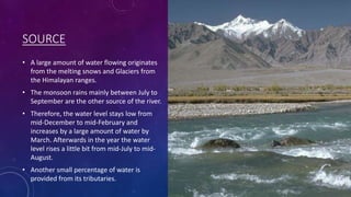
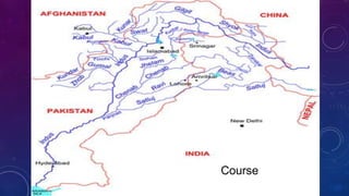
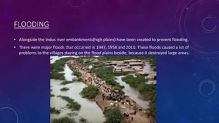
It flows through India!
Go on and be astonished to see the beauty of India!
Read the statistics!
It shows the geographical aspects of the river.
Enjoy!!!!
The Indus River is Pakistan's longest river, originating in Tibet and flowing through northern Pakistan before emptying into the Arabian Sea. It has an extensive basin covering parts of Pakistan, India, China, and Afghanistan, and supports Pakistan's largest irrigation system. This system, which includes major dams like Tarbela and Mangla, numerous barrages and canals, irrigates over 14 million hectares of farmland and is vital to Pakistan's agriculture and economy.
The Indus River is one of the longest rivers in Asia at 3,180 km long. It originates in Tibet near Mount Kailash and Lake Manasarovar and flows through Ladakh, Gilgit-Baltistan, and Khyber Pakhtunkhwa in Pakistan before emptying into the Arabian Sea near Thatta, Sindh. Along its course it passes many other rivers that also eventually flow into the Indus and it is the longest and most important river for Pakistan.
The northern plain of India is formed by three major river systems - the Indus, Ganges and Brahmaputra rivers. This plain covers an area of around 7 lakh square kilometers and is composed of alluvial soil deposited over millions of years. The northern plain is divided into the Punjab, Ganges, and Brahmaputra plains. The Punjab plain lies in the west and is formed by the Indus and its tributaries. The Ganges plain stretches between the Ghaggar and Tista rivers and includes parts of several northern Indian states. The Brahmaputra plain forms the eastern part of the northern plain and lies in Assam.
The document discusses the Upper Indus Plain and Lower Indus Plain in Pakistan. The Upper Indus Plain extends from Jehlum River to Mitthan Kot and contains the confluence of the Indus River and its tributaries. It has a network of canals for irrigation and is suitable for agriculture. The Lower Indus Plain stretches from Mitthan Kot to the Arabian Sea, containing only the Indus River which deposits silt as it flows towards the sea and forms features like meanders and ox-bow lakes. It is also suitable for irrigation-based agriculture.
The document provides information about Pakistan's river system with a focus on the Indus River. It states that the Indus River is Pakistan's longest and largest river, originating in Tibet and running through Pakistan to the Arabian Sea. It notes the other major rivers that flow through Pakistan including the Jhelum, Chenab, Ravi, and Sutlej rivers. The document then provides details on the Indus River Basin, including its reservoirs, barrages, canals, dams such as Tarbela and Gazi Brotha, and the irrigation systems it supports.
The document discusses drainage systems in India. It describes the major river systems including the Himalayan rivers like the Indus, Ganges, and Brahmaputra as well as the peninsular rivers like the Narmada, Godavari, and Kaveri. It also discusses important drainage features like water divides, gorges, deltas, and lakes. Finally, it covers the importance of rivers and lakes for irrigation, hydropower, and their role in the economy, as well as the rising issue of river pollution in India.
This document provides an overview of the physical features and natural topography of Bangladesh, including its location, boundaries, drainage systems and main landforms. It describes how Bangladesh is located in South Asia between India and Myanmar, with most of its area consisting of a broad alluvial flood plain subject to frequent flooding. It then outlines Bangladesh's five major river systems - the Brahmaputra-Jamuna, Ganges-Padma, Surma-Meghna, Tista, and Karnafuli - and the key geographical features associated with these rivers, including meanders, oxbow lakes, braided streams, flood plains, and deltas.
The document discusses several major rivers within the Indus River System located in India and Pakistan. It mentions the Indus River originates in Tibet near Lake Manasarowar and flows through India's Ladakh region before entering Pakistan. It also discusses tributaries like the Shyok River and Nubra River which feed into the Indus. Other key tributaries mentioned include the Jhelum, Chenab, Ravi, Beas, and Sutlej rivers.
This will give you an exciting and entertaining yet Informative detail about the chapter Drainage of class drainage systems OF India, drainage patterns, the Himalayan drainage, the Peninsular Drainage Basins, Lakes and River Pollution are the topics covered.
The document discusses India's drainage systems and major rivers. It describes how the Himalayan and peninsular rivers are the two main groups. The key Himalayan rivers are the Indus, Ganges, and Brahmaputra, which are fed by snow and rain. They discharge about 70% of their flows into the sea. The document provides details on the origins and tributaries of the three major Himalayan rivers.
This document provides an overview of drainage patterns and river systems in India. It begins by defining drainage and describing different drainage patterns such as dendritic, trellis and rectangular. It then discusses the two main river systems in India - the Himalayan rivers which originate in the mountains and are useful for irrigation, and the peninsular rivers which originate in plateaus and have smaller catchment areas. Specific details are given about major rivers like the Indus, Ganga, Brahmaputra, Narmada and others. The document also briefly mentions lakes and the issue of river pollution.
Rivers play an important role in Indian life and culture, providing water for irrigation, transportation, power, and livelihoods. Most major Indian cities are located on river banks. India's river systems originate from three main watersheds - the Himalayas, Vindhya Range, and Western Ghats. The Indus, Ganges, and Brahmaputra are some of India's longest rivers. Rivers have supported ancient Indian civilizations and continue to be vital to society and the environment.
Balochistan is located in southwestern Pakistan, bordering Iran, Afghanistan, and other Pakistani provinces. It has a varied terrain including deserts, mountains, rivers, and forests. The population is mostly Baloch and Pashtun ethnic groups. The climate ranges from hot desert areas to cooler mountainous regions, with low annual rainfall across most of the province. Major geographical features include the Makran coastal mountains, Kharan desert, Bolan river, and Quetta valley.
The document discusses the geography and early inhabitants of India. It describes India as a subcontinent that was formed by a collision with Asia, creating high mountains like the Himalayas. Early settlements developed along rivers in the Indus River valley around 2500 BC, forming large planned cities with sewage systems and religious sites. However, environmental changes like shifting river courses and earthquakes are believed to have undermined the Indus Valley civilization by around 1500 BC.
The document summarizes India's drainage systems and major rivers. It discusses the Himalayan rivers like the Indus, Ganges and Brahmaputra which are fed by rain and snowmelt. These rivers cut through mountains and have long courses. The peninsular rivers are seasonal as they depend on rainfall and have shorter routes. Some flow west into the Arabian Sea while others flow east into the Bay of Bengal, forming deltas. The document also outlines various lakes found in India and the roles rivers play in India's economy and the issues of river pollution.
India's drainage systems are divided into two groups - the Himalayan rivers and the Peninsular rivers. The Himalayan rivers are perennial and flow from the Himalayas, while the Peninsular rivers are seasonal and originate in the Western Ghats. Some key Himalayan rivers are the Indus, Ganges, and Brahmaputra, while major Peninsular rivers include the Godavari, Mahanadi, Krishna, and Kaveri. India also has many lakes that vary in size and origin, such as glacial lakes in the Himalayas and coastal lagoons. Rivers and lakes play an important economic and environmental role but are increasingly threatened by pollution.
This document provides information on major rivers and lakes around the world. It describes the key details of 20 rivers, including their locations, sources, lengths and other geographic features. It also outlines 13 lakes, noting their sizes, locations spanning multiple countries in some cases, and other distinguishing characteristics. The document offers a comprehensive overview of the world's major rivers and lakes.
The document summarizes 10 major rivers around the world, including their locations and key features. The Amazon River is highlighted as the second longest and largest by volume, flowing through South America. The Nile River is the longest and crucial to Egypt's civilization. The Yangtze River is the longest in China and hosts the largest hydroelectric dam. The Danube flows through several European capitals. The Ganges is considered holy in Hinduism. The Mekong supports rich biodiversity but species are endangered. The Zambezi features Victoria Falls. The Volga is the longest river in Europe. The Mississippi drains much of the central US. The Sepik River winds through Papua New Guinea with isolated tribes possessing unique
This document summarizes the drainage systems and major rivers in India. It divides India's rivers into two groups: the Himalayan rivers which originate in the Himalayas and have large catchment areas, and the peninsular rivers which originate in the peninsular plateaus and have smaller catchment areas. It provides details on key Himalayan rivers like the Ganges, Brahmaputra, and Indus, and peninsular rivers such as the Narmada, Tapti, Godavari, Mahanadi, Krishna, and Kaveri. It also discusses the benefits rivers provide like fresh water, irrigation, navigation and hydroelectric power generation.
India has diverse physical features ranging from the Himalayan mountains in the north to the coastal plains and islands in the south. The country can be divided into six major physiographic divisions - the Himalayan mountains, northern plains, peninsular plateau, Indian desert, coastal plains and islands. The northern plains are formed by the interplay of the Indus, Ganges and Brahmaputra river systems. The peninsular plateau consists of the older crystalline and metamorphic rocks of the Deccan trap and forms the tableland south of the Narmada River. India also has coastal plains along the western and eastern coasts and island groups of Lakshadweep and Andaman & Nicobar islands.
Terms Relevant to Geography by Dr. Zafar Iqbal PhDFreelanced
The document defines various geographic and environmental science terms. It provides definitions for river terrace, active glacier, active flood plain, old flood plain, cold water desert, ablation, flash flood, bedload, meander, cyclone, drought, flood, flood exposure, alluvial soil, anthracite, altitude, alluvia, badlands, bituminous, confluence, continental climate, culture, estuary, evapo-transpiration, fall line, and piedmont. The definitions are provided by Dr. Zafar Iqbal and range from 1-3 sentences each.
The document discusses the major river systems of India. It describes the Himalayan rivers as being perennial and fed by snowmelt, with the Indus, Brahmaputra, and Ganga being the major rivers. It then discusses the peninsular rivers, which are seasonal and flow dependent on rainfall. Some notable peninsular rivers mentioned are the Narmada, Tapi, Godavari, Krishna, and Kaveri. The document then provides more details on the courses and basins of several key rivers including the Indus, Brahmaputra, Ganga, Yamuna, Narmada, Godavari, Tapi, Mahanadi, and Kaveri.
India is home to one of the world’s oldest civilizations—the Indus Valley Civilization. India is also home to many rivers of mythological and historical importance, which continue to serve the vast Indian population. With global environmental problems threatening to wreck havoc, India’s rivers too will fall victim unless we take measures to protect them. The power point presentation that follows provides a brief overview of some of India’s major rivers and India’s river based civilizations. The teacher can use this presentation to not only teach children about India’s rivers but also to get them to think of the problems facing some of our rivers—the pollution in the Ganges, for instance or the repercussions of the Sardar Sarovar Dam across the Narmada—and generate a discussion.
Plains, plateaus and deserts in pakistanAqsa Manzoor
The document summarizes the major geographic features of Pakistan, including plains, plateaus, and deserts. It describes the Indus Plain and its tributaries, and divides the Indus Plain into three sections: the Upper Indus Plain, Lower Indus Plain, and Indus Deltaic Plain. It also discusses the Potwar Plateau, Salt Range, Balochistan Plateau, Thal Desert, Cholistan Desert, and Nara and Thar Deserts. The document provides details on the locations, elevations, soils, irrigation, and other characteristics of each of these key geographic regions in Pakistan.
The document discusses the physiography and physical geography of India. It divides India into several physiographic divisions: the Northern and Northeastern Mountains (the Himalayas), the Northern Plain, the Peninsular Plateau, the Indian Desert, and the Coastal Plains. It provides detailed descriptions of each division, including the mountain ranges, rivers, vegetation, and other features of each region.
PPT on India's Drainage System (River System) Rohan Karmakar
The following presentation is on India's drainage or river system. It includes information about some of the major river systems in India. All comments are welcomed. Please LIKE this presentation.
This document summarizes the important rivers in Bangladesh. It discusses that Bangladesh has over 700 rivers that criss-cross the country. The major rivers include the Padma, Meghna, Jamuna, Karnafuli, Teesta, and Brahmaputra. These rivers play a vital role in Bangladesh's economy by supporting agriculture, fishing, trade, and power generation. They also influence the lives and livelihoods of people in Bangladesh.
The document discusses drainage patterns and river systems in India. It describes the major drainage basins including the Ganga, Indus, Brahmaputra, peninsular rivers like Godavari and Mahanadi. The Himalayan rivers are perennial with large basins while peninsular rivers are seasonal with smaller basins. River systems are important for irrigation, hydroelectricity, navigation and more. However, pollution threatens river health and habitats.
Its about major rivers of north India. It helps you all to know some information about north Indian river which flows in many north Indian states including Pakistan also. It contains major information of rivers. Hope you all like it.
CONTENTS
1) A drainage
basin is an extent
or area of land
where water from
rain and melting
snow or ice drain
s downhill into a
body of water.
2) Each drainage
basin is separated
topographically
from adjacent
basins by a
geographical
barrier such as a
ridge, hill or mou
ntain, which is
known as a water
divide.
3)There are four types of drainage patterns:-
➢ Dendritic
➢ Rectangular
➢ Radial
➢ Trellis
4)The drainage systems of India are mainly controlled
by the broad relief features of the subcontinent.
Accordingly, the Indian rivers are divided into two
major groups.
5) The activities of Ganga Action Plan (GAP) phase-I, initiated in
1985, were declared closed on 31st March 2000. The Steering
Committee of the National River Conservation Authority
reviewed the progress of the GAP and necessary correction on
the basis of lessons learnt and experiences gained from GAP
Phase-I. These have been applied to the major polluted rivers of
the country under the NRCP. The Ganga Action Plan (GAP)
Phase-II, has been merged with the NRCP. The expanded NRCP
now covers 152 towns located along 27 interstate rivers in 16
states. Under this action plan, pollution abatement works are
being taken up in 57 towns. A total of 215 schemes of pollution
abatement have been sanctioned. So far, 69 schemes have been
completed under this action plan. A million litres of sewage is
targeted to be intercepted, diverted and treated.
6) Rivers have been of fundamental importance
throughout the human history. Water from the
rivers is a basic natural resource, essential for
various human activities. Therefore, the river
banks have attracted settlers from ancient times.
These settlements have now become big cities.
Make a list of cities in your state which are located
on the bank of a river. Using rivers for irrigation,
navigation, hydro-power generation is of special
significance – particularly to a country like India,
where agriculture is the major source of livelihood
of the majority of its population.
7) The growing domestic, municipal, industrial and agricultural
demand for water from rivers naturally affects the quality of
water. As a result, more and more water is being drained out
of the rivers reducing their volume. On the other hand, a
heavy load of untreated sewage and industrial effluents are
emptied into the rivers. This affects not only the quality of
water but also the self-cleansing capacity of the river. For
example, given the adequate streamflow, the Ganga water is
able to dilute and assimilate pollution loads within 20 km of
large cities. But the increasing urbanisation and
industrialisation do not allow it to happen and the pollution
level of many rivers has been rising. Concern over rising
pollution in our rivers led to the launching of various action
plans to clean the rivers.
If you like the content plz give a like and share with your friends. For any querry contact me on LinkedIn (Link given in my profile).
Rivers have played an important role in the development of civilizations in India. The Indus Valley Civilization and Saraswati River Civilization emerged along major river systems in ancient India. Some of India's most significant rivers that shaped civilizations include the Ganges, Brahmaputra, Kaveri, and Narmada. These rivers originated in the Himalayas and provided water for agriculture, transportation, and supported major settlements and trade. However, modern infrastructure projects also threaten local environments if not implemented sustainably.
The document discusses the drainage systems of India. It describes the two major groups of rivers in India - the Himalayan rivers and the Peninsular rivers. The Himalayan rivers originate in the Himalayas and include the Indus, Ganges, and Brahmaputra rivers. They tend to be longer and receive water from rain and snowmelt. The Peninsular rivers are mostly seasonal and have shorter courses, originating within India. Some examples given are the Godavari, Mahanadi, and Krishna rivers. The document also discusses the different drainage patterns seen in river basins.
The document summarizes several major rivers in India, including the Indus, Ganges, Brahmaputra, Kaveri, Narmada, and Saraswati rivers. It describes the origins and paths of these rivers, as well as the ancient civilizations that flourished along them, such as the Indus Valley Civilization. It notes that rivers played an important role in developing settlements, trade, and agriculture in India. The document concludes that India's rivers are a rich natural and cultural resource that have sustained the country and must be protected for future generations.
The document discusses the drainage systems of India, focusing on the Himalayan river systems. It notes that the major Himalayan rivers are the Indus, Ganges, and Brahmaputra rivers and their tributaries. These rivers originated in the Himalayan mountains even before their formation. They have cut deep gorges and are examples of antecedent drainage. The Indus river system is then described in detail, including its major tributaries like the Jhelum, Chenab, Beas, and Satluj rivers. The document provides locations and details about each of these rivers.
THE INDUS VALLEY CIVILIZATION AND INDUS PLAINSMUHAMMEDAWAIS4
The Indus Valley Civilisation (IVC) was a Bronze Age civilisation in the northwestern regions of South Asia, lasting from 3300 BCE to 1300 BCE, and in its mature form from 2600 BCE to 1900 BCE.
Geographical range: Basins of the Indus River, ...
Dates: c. 3300 – c. 1300 BCE
Indus civilization, also called Indus valley civilization or Harappan civilization, the earliest known urban culture of the Indian subcontinent. The nuclear dates of the civilization appear to be about 2500–1700 bce, though the southern sites may have lasted later into the 2nd millennium bce.
TWITTER : A_R_Muhajir_90
The document discusses drainage patterns and river systems in India. It begins by defining drainage and describing different drainage patterns such as dendritic and trellis. It then summarizes the two major river systems in India - the Himalayan rivers which originate from glaciers, and the peninsular rivers which originate from plateaus. Some key rivers from each system are also introduced, such as the Ganges, Brahmaputra, and Godavari rivers. Lakes and river pollution are briefly covered at the end.
This document discusses flood management and provides information about floods and flood alleviation in India. It begins by defining floods and their causes, including heavy rainfall, snowmelt, and storm surges. It then discusses the dangers of floods, including deaths from drowning. The document outlines design floods and the maximum flood a structure can withstand. It provides details about major rivers in India, including their origins and courses. It discusses the types of floods that occur in India and flood-prone areas. The effects of floods are outlined. Finally, it describes methods used for flood alleviation and control structures like levees.
This document provides information about the drainage system and major rivers of India. It discusses the two main types of rivers - the Himalayan rivers and the peninsular rivers. For the Himalayan rivers, it summarizes the key details about the three major rivers: the Indus, Ganga, and Brahmaputra. It describes their sources, tributaries, and courses through India and neighboring countries. It also briefly outlines some of the major peninsular rivers like the Narmada, Godavari, Mahanadi, Krishna, and Kaveri.
The document provides information on water resources in India including rainfall patterns, river basins, surface water and groundwater availability. It discusses the development of irrigation in India from ancient times to the British period and post-independence. Major irrigation projects implemented across different states are also listed. Key points include: India's annual rainfall is 1170 mm on average but unevenly distributed. Surface water and groundwater availability is around 690 BCM and 432 BCM respectively. Major irrigation projects since 1950s include Bhakra Nangal, Damodar Valley, Hirakud and many others across different states like Nagarjunasagar, Tungabhadra, Gandak, Kosi etc.
Drainag class 9.important ppt for students to studyRajeshKannaA7
This document provides an overview of drainage systems and river systems in India. It discusses the key features of Himalayan rivers like the Indus and Ganges, as well as peninsular rivers such as the Narmada, Godavari and Kaveri. It also covers lakes in India, noting different types of lakes formed by natural or human processes. Additionally, the document outlines the important uses of rivers in India for irrigation, hydroelectricity, industry and more, while also addressing the growing issue of river pollution from waste and efforts under the National River Conservation Plan to improve water quality.
The rivers of India play an important role in the lives of Indians. They provide irrigation, water, transportation, electricity, and livelihoods. Nearly all major Indian cities are located on river banks. The main river systems are the Indus, Ganges, Brahmaputra, and Sutlej. The Indus has 5 major tributaries that flow through India and Pakistan. The Ganges is considered holy in Hinduism and supports a high population density along its basin. It flows southeast through India and into Bangladesh where it empties into the Bay of Bengal. The Brahmaputra flows from Tibet through India and into Bangladesh, merging with the Ganges to form the world's largest delta. The Sutle
The document discusses India's drainage systems and major rivers. It describes the two main river systems - the Himalayan rivers which originate in the Himalayas, including the Indus, Ganges and Brahmaputra Rivers, and the Peninsular rivers which flow eastwards towards the Bay of Bengal. It provides details on the basins and tributaries of major rivers like the Godavari, Mahanadi, Krishna and Kaveri Rivers. It also discusses the roles of rivers in the economy, issues of river pollution, and conservation efforts.
The topography of Pakistan includes four mountain ranges - the Karakoram, Himalayan, Hindu Kush, and Sulaiman ranges. Pakistan also has four major deserts - the Thal, Thar, Cholistan, and Kharan deserts. The country has coastal areas along the Arabian Sea and important ports include Gawadar and Karachi. Major rivers that flow through Pakistan include the Indus, Jhelum, Chenab, Ravi, and Sutlej rivers. Dams have been constructed for water storage and management, including the Mangla and Tarbela dams. Proposed dams like Kalabagh and Diamer Bhasha also have issues related to water
- The major rivers of India play an important role in providing irrigation, water, transportation, electricity and livelihoods. Nearly all major cities are located on river banks.
- There are seven major river systems - the Ganga, Indus, Brahmaputra, Narmada, Godavari, Krishna and Mahanadi. Most rivers drain into the Bay of Bengal while some flow west towards the Arabian Sea.
- The rivers are classified based on their origin - the Himalayan rivers originate in the Himalayas and form large basins, while peninsular rivers flow through shallow valleys and many are seasonal.
This document summarizes information about water bodies in Andhra Pradesh and Punjab from a student named Sagi Bhavya Akshaya. It discusses the major rivers in Andhra Pradesh including the Godavari and Krishna rivers, and water conservation programs in the state. It also discusses the Sutlej, Ravi and Beas rivers in Punjab and water management programs there. The student acknowledges their biology teacher for allowing them to learn about the water bodies in the two regions through this project.
This presentation describes the Argentinian lifestyle and their daily clothing. It is an informative presentation with a lot of information about Argentina. Look up the websites in my Bibliography for further information regarding Argentinian lifestyle.
This presentation describes lots about the metals and non-metals. It also talks about the periodic tabe, physical and chemical properties of metals and non-metals and usses of them. Go ahead and learn beyond the Earth's crust as scientists still continue to dicover new things around the earth. After going through this presentation you will have complete understanding about the metals and non-metals.
Enjoy!!
This presentation describes lots about the solar system, meteors, phases of the moon and comets. Go ahead and learn beyond the Earth as scientists still continue to dicover new things around the earth. After going through this presentation you will have an overview about the space.
Enjoy!!
This is enegy taken from the natural air!
Can you believe electricity being created because of air!
It is practiced on heights or near sea's.
Go ahead and enjoy!
This document provides an overview of autobiography and fiction as genres of literature. It defines autobiography as a biography written by the subject themself, in contrast to a biography written by another person. It notes autobiographies are often written by influential historical figures. Fiction is defined as imaginary or false stories, which can include genres like fantasy, fables, novels, and drama. The document provides examples of autobiographies and outlines some subgenres of fiction, but does not list any specific examples of fictional works.
Walmart Business+ and Spark Good for Nonprofits.pdfTechSoup
"Learn about all the ways Walmart supports nonprofit organizations.
You will hear from Liz Willett, the Head of Nonprofits, and hear about what Walmart is doing to help nonprofits, including Walmart Business and Spark Good. Walmart Business+ is a new offer for nonprofits that offers discounts and also streamlines nonprofits order and expense tracking, saving time and money.
The webinar may also give some examples on how nonprofits can best leverage Walmart Business+.
The event will cover the following::
Walmart Business + (https://business.walmart.com/plus) is a new shopping experience for nonprofits, schools, and local business customers that connects an exclusive online shopping experience to stores. Benefits include free delivery and shipping, a 'Spend Analytics” feature, special discounts, deals and tax-exempt shopping.
Special TechSoup offer for a free 180 days membership, and up to $150 in discounts on eligible orders.
Spark Good (walmart.com/sparkgood) is a charitable platform that enables nonprofits to receive donations directly from customers and associates.
Answers about how you can do more with Walmart!"
This presentation was provided by Rebecca Benner, Ph.D., of the American Society of Anesthesiologists, for the second session of NISO's 2024 Training Series "DEIA in the Scholarly Landscape." Session Two: 'Expanding Pathways to Publishing Careers,' was held June 13, 2024.
Temple of Asclepius in Thrace. Excavation resultsKrassimira Luka
The temple and the sanctuary around were dedicated to Asklepios Zmidrenus. This name has been known since 1875 when an inscription dedicated to him was discovered in Rome. The inscription is dated in 227 AD and was left by soldiers originating from the city of Philippopolis (modern Plovdiv).
This presentation was provided by Racquel Jemison, Ph.D., Christina MacLaughlin, Ph.D., and Paulomi Majumder. Ph.D., all of the American Chemical Society, for the second session of NISO's 2024 Training Series "DEIA in the Scholarly Landscape." Session Two: 'Expanding Pathways to Publishing Careers,' was held June 13, 2024.
How to Setup Warehouse & Location in Odoo 17 InventoryCeline George
In this slide, we'll explore how to set up warehouses and locations in Odoo 17 Inventory. This will help us manage our stock effectively, track inventory levels, and streamline warehouse operations.
Leveraging Generative AI to Drive Nonprofit InnovationTechSoup
In this webinar, participants learned how to utilize Generative AI to streamline operations and elevate member engagement. Amazon Web Service experts provided a customer specific use cases and dived into low/no-code tools that are quick and easy to deploy through Amazon Web Service (AWS.)
The chapter Lifelines of National Economy in Class 10 Geography focuses on the various modes of transportation and communication that play a vital role in the economic development of a country. These lifelines are crucial for the movement of goods, services, and people, thereby connecting different regions and promoting economic activities.
2. INDEX
• Interesting Facts and Information
• Source
• Tributaries/Middle course
• Mouth
• Importance of the Indus River
3. IMPORTANT FACTS AND INFORMATION
• The Indus river flows through India, Pakistan and China but some of its tributaries are from the
nearby countries.
• Alongside the river the archaeologists have found traces of a civilization which is called the Indus
river valley civilization and they found that it began around 5000 years ago.
• Indus river is one of the longest river which lasts for approximately 2000 miles. (Nile river 4135
mi)(India to Yemen = 2026 mi)
• Its total drainage area is approx. about 450,000 square miles.
• The Indus river plays an essential role in providing drinking water and the agriculture of some
regions in Pakistan.
• The Indus river is very polluted because of the factories on the alongside banks.
4. SOURCE
• A large amount of water flowing originates
from the melting snows and Glaciers from
the Himalayan ranges.
• The monsoon rains mainly between July to
September are the other source of the river.
• Therefore, the water level stays low from
mid-December to mid-February and
increases by a large amount of water by
March. Afterwards in the year the water
level rises a little bit from mid-July to mid-
August.
• Another small percentage of water is
provided from its tributaries.
5. TRIBUTARIES/MIDDLE COURSE
• The Indus river is joined by its first major tributary at a short distance from the source(India -
Jammu and Kashmir) which is the Zaskar river.
• Next it is joined by one of its important tributaries in Pakistan administrated - Jammu and
Kashmir which is known as Shyok river.
• After the river crosses the Himalayas it forms a gorge lying near Attock that is 5181 m deep.
• The river is joined by its most notable tributaries from the eastern Punjab region that divides
Pakistan and India. The fiver rivers are Jhelum, Chenab, Ravi, Beas and Sutlej. (Punjab means
“Five rivers”)
• Afterwards in the course the Shigar river joins the Indus at Balistan.
• Farther ahead Gilgit river (a major tributary) also joins the Indus in Pakistan.
6. MOUTH
• Finally, The Indus river gets divided into distributaries that form a delta and enter the Arabian
Sea at the Southeast of Karachi.
• The delta covers an area of around 3000 square miles and is 130 miles long.
Indus River Delta
8. IMPORTANCE OF THE RIVER
• The Indus river is important for the 160 million people in Pakistan because the river is the
source of drinking water of all these people.
• The river also irrigates 80% of Pakistan’s 21.5 million hectares of agricultural land.
• The Indus river provides home to a large amount of species.
9. FLOODING
• Alongside the Indus river embankments(high plains) have been created to prevent flooding.
• There were major floods that occurred in 1947, 1958 and 2010. These floods caused a lot of
problems to the villages staying on the flood plains beside, because it destroyed large areas.