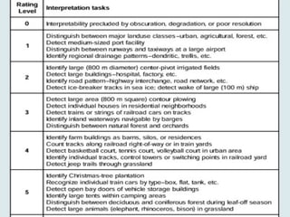
Visual Interpretation
• Visualinterpretation of aerial photographs is based
on recognition of objects.
• Tone and Colour
• Shape
• Size and height
• Shadow
• Pattern
• Texture
• Context
Flooding caused bya beaver
dam in the Jossa Valley near
Mernes (Spessart), Germany.
On the inundated floodplain
between the Jossa River (J)
and the main irrigation ditch
crossing the upper part of
the image (D), a multi-
channel drainage network
and small lake have
developed.
Vegetation and Agriculture
Plantheights, patterns, textures, and color
variations are visual clues for recognizing
distinct vegetation zones in these coastal
wetlands.
26.
Cultural Heritage andArchaeology
• Historic and prehistoric human-made structures
including houses, churches, canals, roads, mills,
monuments, graveyards, and other constructions.
• Size, shape, pattern, shadow, context, and other
basic visual clues are important for recognizing and
identifying such human structures, whether modern
or ancient.
• Human structures tend to display regular, linear,
geometric shapes and patterns that contrast with
natural objects.
Soil
Soil discolorations inaerial photography
are helpful aids for archaeology as well
as soil science.
• small-scale distribution of soil units,
• soil thickness and degradation state
of the soil
• old postholes
• Pits
• walls
• individual soil horizons
30.
Applications
• There arevarious applications of aerial
photography, such as cartography, urban
planning and development, weather
forecasting, archaeology, and military
surveillance.
31.
• Aerial photogrammetryis a technique that uses overlapping images taken from an elevated position to
create detailed maps and models. It has many applications, including:
• Mapping
• Aerial photogrammetry is a common way to create maps from aerial photos. It can provide a more
accurate view of an area than ground-based mapping.
• Architecture
• Photogrammetry can create 3D models and measurements of buildings and sites. This can help with
documentation, restoration, and preservation.
• Mining
• Aerial photogrammetry can help geologists and engineers find geological structures and outcrops of
material.
• Disaster relief
• Aerial photogrammetry can be used in disaster relief efforts.
• Archaeology
• Photogrammetry can help archaeologists quickly make plans of large and complex sites.
• Meteorology
• Photogrammetry can help meteorologists determine wind speeds of tornadoes when weather data is
unavailable.