3.1. Emergence ofStates
One important factor for the emergence of states was
the beginning of
beginning of sedentary agriculture
sedentary agriculture.
Families preferred to live together forming larger
communities for
better security
better security
to
to help each other
help each other in hard works.
hard works.
3.
Therefore, states wereformed mainly through
the expansion of agriculture that gave rise to class
class
differentiation.
differentiation.
Furthermore, the growth of trade facilitated the
development of states
development of states.
farmers acquired surplus produce to exchange
exchange with
better tools and clothes
better tools and clothes with the artisans
who were able to specialize in the production of
these items
Gradually, intermediaries (traders) also began to buy the
products of both to take to
predetermined places or markets for exchange
4.
State refers toan autonomous political unit having
population,
defined territory,
sovereignty
government with the power to decree and enforce laws
State was the outcome of regular cultural process.
states arose independently in different places and at
different times
Favorable environmental conditions helped to hasten
the rate of transformation in some regions.
Religious leaders such as shamans played prominent role
in maintaining
the social and religious affairs of their people
during the initial formation of the states
5.
religious elites weregradually replaced by chiefs
Then they began collecting regular and
compulsory tributes which amounted to protection
payments
with which they maintained themselves,
their supporters chiefly the army,
the bureaucracy and other followers
6.
Ethiopia and theHorn is one of the regions in Africa
where early state formation took place.
From small beginnings, such states gradually
developed into
powerful kingdoms
even empires with a well-demarcated social
structure
Early state in Ethiopia and the Horn were stronger than
their neighbors and eventually dominated them.
This was due to
Geographical proximity to and control of the
international water bodies along with their ports like
Red Sea,
Red Sea,
Gulf of Aden
Gulf of Aden
Indian Ocean
Indian Ocean
8.
3.2. Ancient States
3.2.Ancient States
3.2.1. North and Northeast
3.2.1. North and Northeast
A. Punt
A. Punt
Punt was the earliest recorded state in Ethiopia and the Horn
The evidence on Punt
Punt comes from Egyptian hieroglyphic
writings
accompanied by vivid paintings that describes
describes series
series
of
of naval
naval expedition,
expedition,
which the Egyptian Pharaohs sent
sent to Punt
Pharaoh Sahure (2743-2731 B.C.) sent
sent expedition to
collect myrrh, ebony and electrum (gold and silver alloy)
During Pharaoh Asosi, treasurer of God Bawardede took
dancing dwarf “dink" to Egypt from Punt.
9.
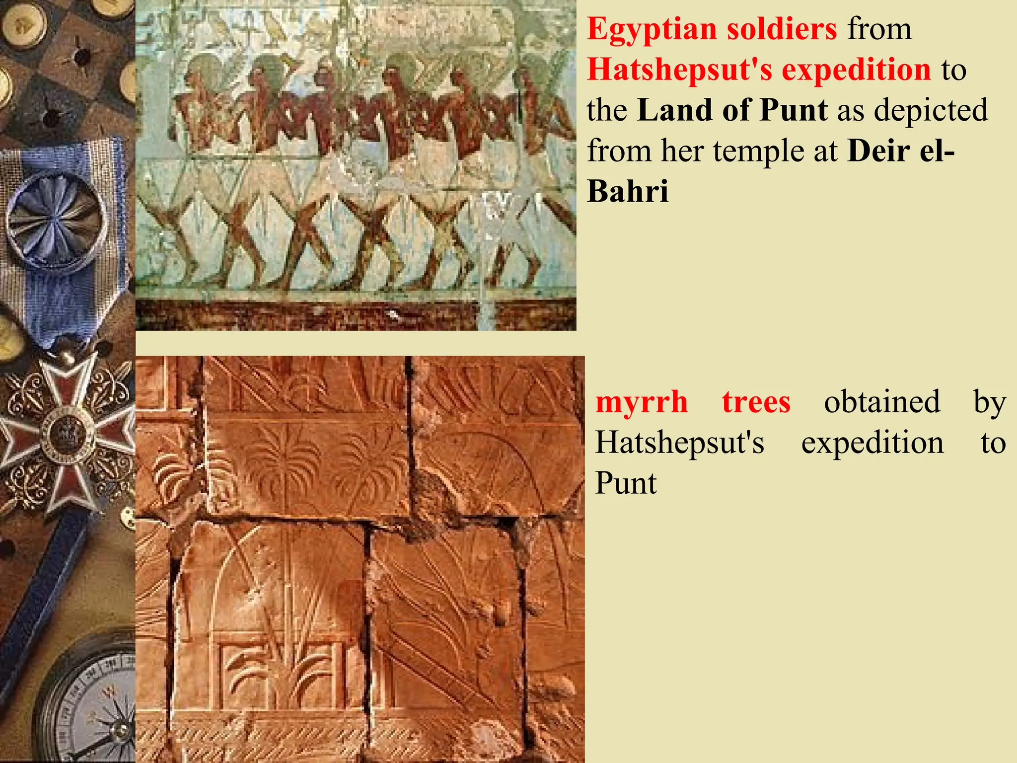
The best describedand illustrated expedition was which
undertaken by the order of the famous Egyptian Queen
Hatshepsut (1490-1468 B.C.), whose expedition
expedition is
documented
documented at her tomb in Dier El Bahri
She sent five ships under the leadership of Black
Nubian Captain Nehasi via Wadi-Tumilat
The expedition was warmly welcomed by
the Puntites King Perehu, his wife Ati, sons,
daughters and followers.
The expedition
expedition was able to return collecting
frank incense, cinnamon,
sweet smelling woods (sandal), spices,
ivory, rhinoceros horn, leopard and
leopard skins,
ostrich feathers and egg, live monkeys,
giraffes, people
10.
Hatshepsut presented someparts of the items to her god,
Amun
It was because of the ritual importance of their
exports that Puntites were also known as
Khebis of the Ta Netjeru (divine or ghosts land)
Iron, bronze, asses, foxes, cattle, animals fur, dying and
medicinal plants were also exported from Punt to Egypt
In return, from Egypt the following were imported to
Punt
axes, daggers, swords, knives, sickles, clothes,
bracelets, necklaces, beads and other trinkets
11.
Scholars have notreached agreement as to the exact
location of Punt
1. The varieties of incense and myrrh mentioned in the
writings have suggested
it was in northern or northeastern Somalia
northern or northeastern Somalia
2. some scholars while others are inclined more towards
Northern Ethiopia
Northern Ethiopia
because of the reference to gold, ivory and monkeys
The latter reinforce their arguing at that early period
Egyptian sailboats might not have been strong enough
to pass through
the Strait of Bab-el Mandeb into the Gulf of Aden
and the Indian Ocean.
3. Considering the two suggestions, still some others argue
that
it probably stretched from Swakim or Massawa to
Babel Mandeb (Gate of Tears) and Cape Guardafui.
12.
Egyptian soldiers from
Hatshepsut'sexpedition to
the Land of Punt as depicted
from her temple at Deir el-
Bahri
myrrh trees obtained by
Hatshepsut's expedition to
Punt
B. Da’amat andOther Cultural Centers in
Northern Ethiopia and Eritrea
The state known as Da’amat had a center a little to the
south of Aksum
Inscription of the king of Da’amat tentatively dated to the
fifth century BC shows that
he used politico religious title
politico religious title known as Mukarib.
Various gods and goddesses were worshipped
in the Da’amat state and northern Ethiopian pre-
Aksumite cultural centers
Such as
Almouqah (principal god),
Astarr (Venus god),
Na’uran (light god),
Shamsi (sun god),
Sin (moon god)
There were similar practices in South Arabia at the time
15.
There were anumber of cultural centers
number of cultural centers in northern
Ethiopia. The major ones are:
Yeha
is located 30 kms to the northeast of Aksum
It was the oldest of these centers
It probably emerged around 1, 000 BC as a small
emporium
where South Arabian merchants
South Arabian merchants and their
agents
agents bought and stored
ivory, rhinoceros horn and other
commodities coming from the interior
It seems that the period of its prosperity (zenith) was
from about 750 to 500 B.C
Remains of walls of some of its buildings and stone
masonry as well as still standing temple
inscriptions indicate Yeha’s glory
17.
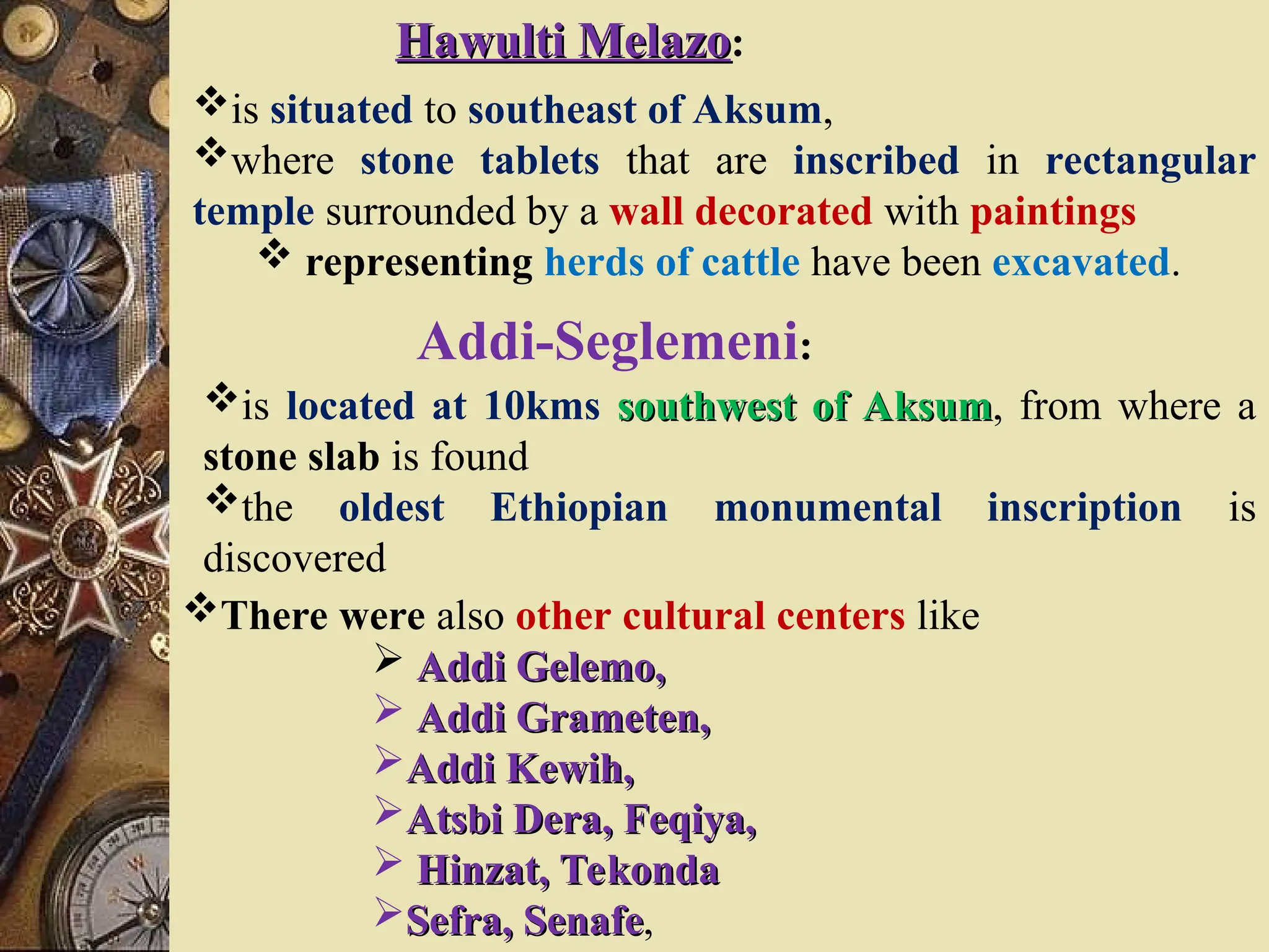
Hawulti Melazo
Hawulti Melazo:
issituated to southeast of Aksum,
where stone tablets that are inscribed in rectangular
temple surrounded by a wall decorated with paintings
representing herds of cattle have been excavated.
Addi-Seglemeni:
is located at 10kms southwest of Aksum
southwest of Aksum, from where a
stone slab is found
the oldest Ethiopian monumental inscription is
discovered
There were also other cultural centers like
Addi Gelemo,
Addi Gelemo,
Addi Grameten,
Addi Grameten,
Addi Kewih,
Addi Kewih,
Atsbi Dera, Feqiya,
Atsbi Dera, Feqiya,
Hinzat, Tekonda
Hinzat, Tekonda
Sefra, Senafe
Sefra, Senafe,
C. The AksumiteState
The nucleus of the Aksumite state was formed around 200-
100 B.C.
Initially, its power was limited to a relatively small
area comprising the town of Aksum and its environs
Gradually,, it expanded to include large territories in all
directions.
In its heyday,
In its heyday, Aksumite territories extended from
the Red Sea coast in the East to the Western edge of
Ethiopian plateau the vast Nile Valley in the west
from the northern most corner of Eritrea and possibly
as far south as northern parts of Shewa
20.
According to Periplusof Erithrean Sea,
Adulis on the western coast
western coast of the Red Sea
Red Sea was the
major port of Aksum
major port of Aksum
The long distance trade routes from Adulis and other posts
on the Red Sea coast passed inland through such centers as
Kaskasse, Coloe, Matara and even further west
across Takaze River.
The document also mentioned
ports of Aden (Eudaemon)
Gulf like Avalites (Zayla)
Malabo (Berbera),
Indian Ocean Benadir Coasts like
Serapion (Moqadishu), Nicon (Brava) and
Merca
21.
The major itemsof export of the Aksumite state consisted
mainly of the natural products such as
ivory, myrrh, emerald, frankincense
some spices (like ginger, cassia and cinnamon),
gold, rhinoceros horns, hippopotamus hides,
tortoise shells and some curiosity animals like apes
In turn, a number of manufactured products were
imported like
garments and textiles from Egypt, India, the Roman
Empire, and Persia;
glassware and jewelry from Egypt
metallic sheets, tools or utensils of various kinds, oil
and wine from the regions of Roman Empire and Syria
22.
During Aksumite periodthere was inter state relation for
this there are some evidences
Zoscales
Zoscales (c. 76-89), the then king of Aksum, used to
speak the
Greek language, the Lingua Franca of Greco-
Roman world.
Aksum also had relations with Ceylon (Sri Lanka) and
Laodicea (Asia Minor)
23.
During Aksumite periodthere was the internal long
distance trade
Christian Topography, describes Aksum and a
distant region called Sasu,
most probably in Beni Shangul and the adjoining
lands beyond the Blue Nile
Aksumite kings had extensive contacts with the outside
world notably with the South Arabian region,
leading to exchange of ideas
exchange of ideas,
, material
material and
spiritual culture
Sometimes such contacts involved conflicts between the
two regions.
One of such known recorded conflict between areas on
both sides of the sea took place around 200 A.D.
peoples in Southern Arabian Peninsula, in present day
Yemen,
had difficulties in defending themselves against the
army of the Aksumite king, Gadarat.
24.
From the thirdto the seventh centuries, Aksumite kings
like Aphilas, Endybis, Wazeba, Ezana, Ousanas II,
Aphilas, Endybis, Wazeba, Ezana, Ousanas II, etc.
minted and issued different kinds of coins
kinds of coins in gold
gold,
silver
silver and bronze for
both overseas and local transactions.
At the time Aksum was one of the four great powers of the
world
Roman Empire,
Persia,
China
Aksum
25.
It was amajor naval and trading power from the first to
the seventh centuries.
Aksumite ships were the main means
main means of transporting
goods
In those days, Aksum was the only one with
sufficient sources of timber for ship building
the technology for it existed in Adulis.
Aksum had a large fleet of ships, which was used not
only for trade but also for its wars across the Red Sea
26.
Kaleb (r. 500-35)expanded overseas territories of Aksum
beyond Himyar and Saba
but the local prince Dhu-Nuwas
local prince Dhu-Nuwas was converted to
Judaism, marched to Zafar
Zafar and Nagran
Nagran,
killed many Christians
then Byzantine Vasaliev Justinian (r. 527-65) with
sanctification of Patriarch Timit III (518-538) provided
Kaleb with a number of ships to transport armies led
by Julianos and Nonossus against Dhu Nuwas
Dhu Nuwas was defeated and Kaleb appointed
Abraha as governor of Arabia until 570 A. D
Kaleb was succeeded
succeeded by his son Gabra Masqal (535-
48) who built a church at Zur Amba in Gayint
Gayint
It was during Gabra Maskal that Yared developed
Ethiopian Orthodox Church liturgical songs and hymns
hymns
27.
The Aksumite statebegun to decline
decline since the late seventh
century because of internal and external challenges.
Natural factors
environmental degradation,
decline in agricultural productivity
possibly plague infestation started to weaken it
External Challenges
With the destruction of the port of Adulis by the Arabs
around 702,
the international lifeline of the state was cut.
Aksumite international trade came under the control of the
rising and expanding Arab Muslims
expanding Arab Muslims,
It isolating the Aksum state from its old commercial
and diplomatic partners.
Consequently, the Aksumite state declined
Aksumite state declined economically
economically
28.
Internal challenges
Aksumite hegemonywas challenged by local rebellions.
For example rebellions of
the Beja people
Beja people ,
,
the Agaw people
Agaw people
Queen Bani al Hamwiyah (Yodit)
Queen Bani al Hamwiyah (Yodit) finally
sealed the collapse of the Aksumite state
However, as a civilization, Aksum had a profound impact
upon the peoples of the Horn of Africa on its successors
the Zagwe,
‘Solomonic Dynasty’,
the Gondarine period etc.
29.
Some of itsachievements of the Aksumite State include
Sub-Saharan Africa’s only surviving indigenous script
calendar
EOC hymns and chants,
paintings
diversified ceramic
lithic tools, ivory curving,
urbanization
sophisticated building traditions (palaces, stele, rock-
hewn churches)
it also developed complex administrative and governance
system,
agricultural system including irrigation etc
32.
D. Zagwe Dynasty
D.Zagwe Dynasty
After its decline, the center of Aksumite state shifted
southwards to Kubar rural highland in the territory of
the Agaw,
one of the ancient inhabitants of the land between
the Eritrean Plateau and Jema River,
and to the west up to the Blue Nile valleys
This apparently gave Agaw elites
Agaw elites the opportunity to take
part in Aksumite state structure
serving as soldiers and functionaries
soldiers and functionaries for at least four
centuries.
After integrating so well with Aksumite ruling class,
they successfully
successfully took over the state
administration
33.
Accordingly, the Agawprince Merra Teklehaimanot
married Masobe Worq,
the daughter
daughter of the last Aksumite king
last Aksumite king Dil Na'od
Dil Na'od.
Later he overthrew his father-in-law and took control
of power.
Merra-Teklehaimanot's successors
successors include
Yimirahana Kirstos
Yimirahana Kirstos,
, Harbe, Lalibela
Harbe, Lalibela (1160-1211),
Ne'akuto La'ab, Yetbarek
Ne'akuto La'ab, Yetbarek etc
Notwithstanding the debates, the Zagwe Dynasty is
believed to have ruled from c. 1150 to 1270
34.
The Zagwe Dynastymade its center
in Bugna District within Wag and Lasta,
more exactly at Adafa near Roha (Lalibela).
The territory of the Zagwe kingdom extended from
highland provinces of the ancient Aksumite kingdom
in the north down
to northern Shewa in the south
the Lake Tana region
the northern part of what is today Gojjam in the west
35.
The Agaw maintainedthe ancient Aksumite traditions
almost intact.
Zagwe rulers renewed
renewed cultural and trade contact with
eastern Mediterranean region
The most important export items included
slaves, ivory
rare spices
cotton, linen, silver and copper vessels,
various types of drags and newly minted coins were
imported.
36.
Furthermore, the Zagweperiod was
a golden age in Ethiopia's paintings
the translation of some religious works from Arabic
into Ge'ez.
Zagwe rulers are best known for the construction of
cave, semi-hewn and monolithic churches
churches:
1. Cave:
with some decoration inside, almost similar with
natural cave, e.g. Bete-Mesqel.
2. Semi-hewn:
this and the monolithic churches that have become
UNESCO world heritage are unique in constructions
They are not totally separated from the surrounding
rock.
Their roofs or walls are still attached to the rock,
eg. Bete Denagil, Bete Debresina/Mikael, Bete
Golgota, Bete Merqoriwos, Bete Gabri’el-Rufa’el
and Bete Abba Libanos.
37.
3. Monolithic:
with detaileddecoration in the interior and exterior parts.
They are completely separated (carved out) from
surrounding rock,
eg. Bete Amanuel, Bete Giyorgis, Bete Mariyam and
Bete Medhanialem.
Among the eleven churches of Lalibela, Bete
Medhanelem is the largest of all
Bete Giyorgis is said to be the most finely built in the
shape of the Cross.
Lalibela wanted to establish the second Jerusalem, and
mitigate or even avoid difficulties,
which Ethiopian Christians encountered in their
journey to the Holy Lands
This was done by constructing churches based on the
model of Holy Lands in Israel
The
The Zagwe Dynastycame to end
Zagwe Dynasty came to end due to
due to internal problems
internal problems
of
of royal succession
royal succession
oppositions
oppositions from
from groups
groups claiming
claiming descent
descent from the
from the
ancient rulers of Aksum
ancient rulers of Aksum
The
The latter
latter considered
considered Zagwe kings “illegitimate
Zagwe kings “illegitimate
rulers”
rulers” based on the
based on the legend of the Queen of Sheba
legend of the Queen of Sheba
The
The legend
legend was in turn
was in turn based
based on a
on a book
book known as
known as
Kebra-Negest (Glory of Kings
Kebra-Negest (Glory of Kings)
)
that was
that was translated from
translated from Coptic to Arabic
Coptic to Arabic and then
and then
into
into Ge’ez
Ge’ez
based on the legend, the power claimants contend that
“Solomonic” Dynasty ruled the Aksumite state
until its power was “usurped” by the Zagwes.
41.
Yekuno-Amlak (r. 1270-1285),who claimed decent from
the last Aksumite king Dilna’od,
organized his forces with the assistance of the
ecclesiastical hierarchy
engaged the last king of Zagwe, Yetbarek in battle
Yetbarek was killed in Gaynt and Yekuno-Amlak took
the state power proclaiming
the “restoration” of “Solomonic Dynasty
restoration” of “Solomonic Dynasty.
.
42.
3.2.2. East, Central,Southern, and Western States
3.2.2. East, Central, Southern, and Western States
3.2.2.1. Bizamo, Damot, Enarya and Gafat
3.2.2.1. Bizamo, Damot, Enarya and Gafat
A) Bizamo:
It was a kingdom located on the southern bend of Abay
River
just opposite to the present districts of Gojjam and
around the current Wambara area.
It was founded in the 8
8th
th
century
century and had early
connections with Damot
Damot.
43.
B) Damot
Damot:
It wasstrong kingdom that expanded its territories into
most of the lands to south of Abay
north of Lake Turkana as well as west of Awash and
east of Didessa.
Motalami was a prominent king of Damot in the 13th
century.
44.
C) Enarya
Enarya:
It wasa kingdom in the Gibe region in south-western
Ethiopia.
The royal clan was Hinnare Bushasho (Hinnario Busaso).
Hinnare Bushasho (Hinnario Busaso).
Enarya kingship was a divine one: the king (Hinnare-
the king (Hinnare-
Tato
Tato)
) was secluded and considered as sacred.
He communicated visitors through an intermediary, Afe
Busho.
45.
In the 9th
century,Aksumite king Digna-Jan is said to
have led a campaign into Enarya,
accompanied by Orthodox Christian priests carrying arks
of covenant (tabots).
46.
D) Gafat:
D) Gafat:
historically,the territory of Gafat
territory of Gafat lies
south of Abay (Blue Nile) River adjoining Damot on
the south western periphery of the Christian Kingdom.
Semitic speaking population related to Adere and the
Gurage inhabited it.
It is not clear from available records whether the Gafat
formed a “state” or not,
“state” or not,
but Gafat mountains provided a rich source of gold.
rich source of gold.
47.
Despite efforts byChristian evangelists, the Gafat
Gafat largely
remained practitioners
practitioners of their own indigenous religion.
As of early medieval period, Gafat was paying tribute to
the Christian Kingdom mainly in cattle,
which came from six districts, among which
Gambo and Shat are Gafat clan names.
The province was ruled by the title of Awalamo
Awalamo.
48.
After the spreadof Islam since the beginning of the 8th
century,
Muslim communities and states had been established at
many locations
especially along the main trade routes from Zeila
Zeila and
its many branches penetrating the interior.
These states include:
A)Shewa:
Makhzumi Khalid ibn al-Walid, who claimed decent from
Mecca, set up Makhzumite Sultanate in 896 A. D (283 A.H.)
on north-eastern foothill of Shewa.
49.
B)Fatagar:
was founded aroundMinjar, Shenkora and Ada’a in the 11th
century.
It was a hilly lowland area with thoroughly cultivated
fields of wheat and barley, fruits,
It was also extensive grazing grounds full of numerous
herds of cattle, sheep and goats.
50.
C) Dawaro:
It wasLocated
south of Fatagar between upper waters of Awash and
WabiShebelle
extending to Charchar in Northeast and Gindhir in
Southeast.
It was much smaller than Ifat, but resembled.
They have a currency called hakuna in which transition
takes place.
51.
D) Bali:
It wasan extensive kingdom occupying high plateau,
separating basins of Shebelle and Rift valley Lakes.
Bali was one of the largest of Ethiopia’s Muslim
provinces.
Its economic activity
economic activity resembles those of other nearby
Muslim lands.
Trade was mainly based on barter exchanging cattle, sheep,
cloth etc.
It had strong army composed of cavalry and infantry.
52.
E. Ifat:
It wasa state located in the adjacent to Shewan Sultanate.
Its territory ran from northeast south-westerly in the
Afar plain eastward to the Awash.
It was established by Umar Walasma, who claimed decent
from Hashamite clan and came from Arabia between 1271
and 1285.
He intervened between quarrelsome Makzumite princes
DilMarrah
DilMarrah and Dil-Gamis
Dil-Gamis, weakened and annexed the
sultanate of Shewa.
53.
The sultanate wasfertile and well watered.
well watered.
Its inhabitants earned their living from cultivation of
wheat, sorghum, millet and teff, and animal husbandry.
Sugar cane, bananas, variety of fruits, beans, squashes,
cucumbers, and cabbage completed the diet.
Chat was described for the first time as being consumed as a
stimulant.
54.
F. Others:
autonomous statesmutually independent states like
Arababani (between Hadiya and Dawwaro), Biqulzar,
Dera (between Dawaro and Bali), Fadise, Gidaya, Hargaya,
Harla, Kwilgora, Qadise, Sharkah (West of Dawaro and
North of Bali in Arsi) and Sim were established and
flourished.
55.
3.3. External Contacts
Ethiopiaand the Horn had contacts with Egypt since at
least 3,000 B. C.
It had very close relations with all commercially active
South Arabian Kingdoms starting before 1,000 B.C.
The introduction of Christianity to Aksum established a
new pattern of relation between the region and Egypt.
Until the introduction of Islam into Egypt and the general
reduction of the Christians into minority,
relations between the two were fairly smooth and
friendly.
56.
Following the introductionof Christianity,
Aksum had established close relationship with the
East Roman or Byzantine Empire.
Yet, in the 7th
century, this relation became
complicated and began to deteriorate.
The rapid expansion of the Muslim Arabs through the
Near and Middle East, North Africa and the Nile valley led to
the decline of Aksumite land routes and shipping
lines.
57.
Successive Egyptian Muslimrulers began to use the
consecration and sending of a bishop
as an instrument to further their own foreign policy
objectives
The coming to power of the Mamluk in Egypt was
followed by the persecution of religious minorities.
Moreover, the Mamluk presented a barrier to the contacts
between Christian Ethiopia and European states.
58.
There was EthiopianChristian pilgrims to the Holy land
of Jerusalem.
When pilgrims
pilgrims met their fellow Christians of Europe
fellow Christians of Europe in
the holy places, they transmitted information about
the EOC
EOC and about the territorial extent
territorial extent of the
Christian Kingdom
Christian Kingdom.
.
From the information, the Europeans began to
consider Ethiopian Christian Kingdom
Ethiopian Christian Kingdom
as a very powerful and wealthy state existing in the
Horn of Africa.
59.
Consequently, they wantedto use this imaginary strong
Christian power
in their struggle against the Muslim powers in the
Holy land.
Around the middle of the 12th
century, a myth about a very
rich and powerful Christian ruler known as Prester John began
to circulate in Europe.
The legend was developed when the balance of the
crusade war fought over Jerusalem
between the Christians of Europe and the Muslims
of the Middle East was in favor of the Muslims.
60.
The geographical locationof the country of Prester John
was not known to Europe for over a century.
However, the Europeans began to regard Ethiopian
Christian Kingdom as the land of Prester John.
land of Prester John.
Then, they began to search for the location of the Kingdom
and to make an alliance with it.
61.
3.4. Economic Formations
A.Agriculture and Land Tenure System
The main stay of ancient states' economy in highland areas
was plough agriculture.
Land has always been one of the most precious possessions
of human society throughout history.
The rules according to which members of the society
members of the society hold,
share, and use land constitute is known as the land tenure
system.
62.
The most ancientsystem of land holding in many parts of
Ethiopia and the Horn is the communal land tenure system.
Communal right to land is a group right.
Here group refers to the family, the clan and the other
lineage groups to which the individual belonged.
Each of these groups had communal right to the land
they lived in
freely exploited the resources of the land.
63.
Peasants in thenorth had rist rights in their respective
areas.
Rist is a kind of communal birth right to land by
members of the families and clans whose ancestors had
settled and lived in the area over long periods.
It is inherited from generation to generation in
accordance to with customary law.
Most of the subjects of the state had the rist rights.
64.
The rist ownerswere known as bale
bale-
-rist
rist.
.
Yet, they paid tributes to the state and all land
belonged to the state theoretically.
Tribute was collected through a complex hierarchy of
state functionaries or officials
this officials given gult right over the areas and
populations they administered on behalf of the central
government.
65.
Gult is aright to levy tribute on rist owners’ produce.
The tribute collected by bale-gults, partly allotted for
their own up keep and the rest were sent to the imperial
centre.
Gult right that became hereditary was called Riste-Gult
as famous well placed officials used to transfer their
position to their offspring.
66.
B. Handicraft
Indigenous handcrafttechnology had existed since the
ancient period.
The social, economic and political conditions of ancient
states had allowed
the emergence of artisans in various fields with
diverse forms and applications including
metalwork
pottery,
tannery, carpentry,
masonry, weaving,
jewellery, basketry and others.
67.
Metal workers producedspears’ points, swords , javelins,
bows, arrows, traps, slings, slashers, shields, knives, axes,
sickles, hoes, ploughshares, spades, machetes, hatchets, iron
tripods, ornaments etc.
Carpenters engaged in carving wood implements like doors,
windows, stools, chairs, tables, beds, headrests, mortars,
bowls, beams, yoke, stilt, coffins etc.
68.
potters produced ceramicutensils like saucepan, ovens, jar,
pot, kettle, cooking tripod, plates, granary etc.
Tanners produced leather tools used for bed, bed cover,
saddles, harness, ropes, footwear, prayer mats, sacks, honey
and butter container, drinking cup and clothes until replaced
by weavers’ cotton dresses
69.
However, the artisanswere mostly despised and
marginalized because of the general wrong public attitude.
The ruling classes mostly spent their accumulated
wealth on imported luxurious items rather than
the domestic technology.
Due to this, the locally produced agricultural implements
and house furniture did not show
any significant improvement and sophistication.
70.
C. Trade
Trade wasanother important economic activity of ancient
states that obtained considerable income from
both internal and international trade.
Ethiopia and the Horn was crisscrossed by various trade
routes connecting various market places in all directions.
71.
3.5. Socio-cultural Achievements
3.5.Socio-cultural Achievements
A. Architecture
As the states expanded, architecture also began to
flourish
one of the unique architectural technologies was the
engraving of stele around the third century AD.
There were totally fifty eight steles in and around Aksum
that can be grouped into
well made and decorated,
half completed
megaliths (not hewn).
As local tradition says, the steles were engraved specifically
at Gobodara
Then which they were transported and planted in
Aksum.
72.
The longest oneof these stele measures 33meters heights
(the first in the world).
It is highly decorated in all of its four sides.
It represents a-14 storied building with many windows
and a false door at the bottom.
It also bears pre-Christian symbols, which are a disc
and a crescent half moon) at the top.
Some scholars suggest that this giant stele was broken
while the people were trying to erect it
73.
The second longestobelisk measures 24 meters height
that was successfully erected
represents a ten-storied building with many windows
and a false door at the bottom.
The third longest stele measures 21 meters
represents a nine-storied building with many windows
and a false door at the bottom.
It is smooth at the back of its side with no decoration
74.
The Zagwe churchesare one of the finest architecture of
artistic achievements of the Christian world
Due to this they were registered by UNESCO as part
of world cultural heritage in 1978.
Further refinement can be observed in the construction
and decoration of the rock hewn churches
Zagwe architecture used a softer material like
sandstone
sandstone, which was cut and shaped all round,
except the floor, into a variety of delicately
decorated churches.
75.
B. Writing System
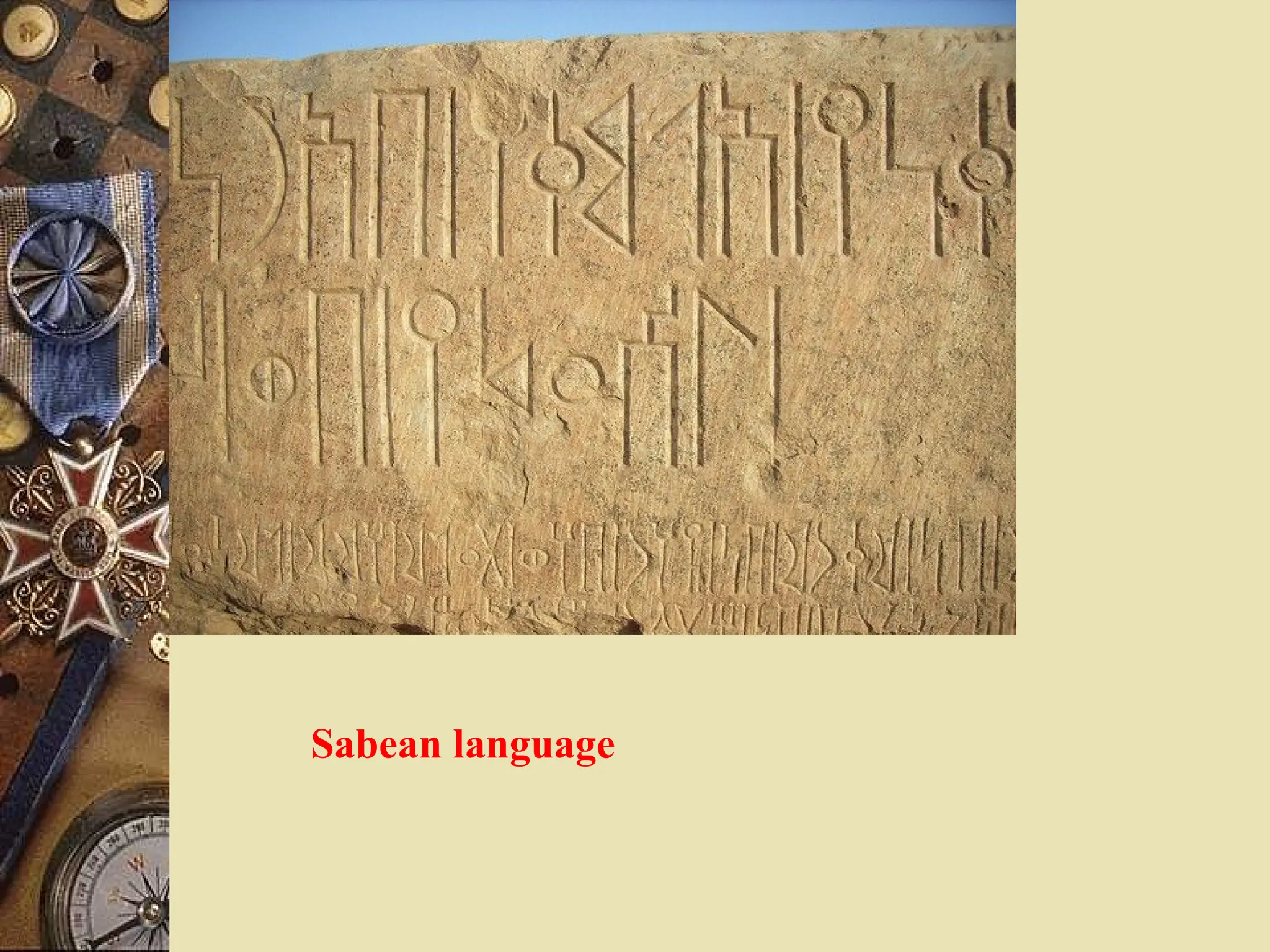
TheSabean language had an alphabet with
boustrophedon writing type
that is paleographical writing from left to right
and right to left alternatively.
The earliest Sabean inscriptions in Eritrea and
Ethiopia date to the ninth century BC.
One peculiar feature of Sabean inscriptions is
absence of vowels
absence of vowels
as most of the words are written in consonants
written in consonants.
For instance, Da’amat was inscribed as D’mt,
while its successive kings are written as RDM,
RBH and LMN using title, mlkn
After the seventhand sixth centuries BC, however,
variants of script arose,
This evolution can be seen most clearly in evidence
from inscriptions
inscriptions mainly graffiti
graffiti on rocks and caves.
By the first century AD, "Ge ez alphabet" arose
ʽ ,
an abjad (26 consonant letters only) written left-to-right
with letters identical to the first-order forms of modern
vocalized alphabet
the first completely vocalized texts known are
inscriptions by Ezana
(who left trilingual inscriptions in Greek, Sabean
and Ge'ez) c. 330 AD,
vocalized letters predate him by some years,
as vocalized letter exists in Wazeba’s coin
some 30 or so years before
78.
The process wasdeveloped under the influence of
Christian scripture by adding vocalic diacritics for vowels,
u, i, a, e, ə, o, to the consonantal letters in a recognizable
Ethiopia's ancient indigenous writing system has
immense contribution to the development of
literature,
art
the writing of history.
79.
C. Calendar
People neededto know and remember the times
when the rains would begin and end as well as the rise
and fall of the water level
In due course, calendars were invented.
In most cases, the length of the month was based on the
movement of the moon or the apparent movement of the sun.
Otherwise, the number of days in the week or in the year
varied from region to region
80.
Calendars were developedand adopted among various
peoples of Ethiopia and the Horn.
Oromo calendar
Oromo calendar has been based on astronomical
observations of moon in conjunction with seven or eight
particular stars or group of stars called
Urjii Dhahaa (guiding stars) and Bakkalcha (morning
star)
There are 29.5 dates in a month and 354 days in 12
months of a year.
Pillars (dated 300 B.C.), which were discovered in
northwestern Kenya
northwestern Kenya from 1978-86 by
Archaeologists Lynch, Robbins and Doyl have
suggested
They enlighten site used to develop Oromo calendar.
In connection with this, c. 900 A. D. Oromo person
Waqlim is said to have taken
art of shaping phallic bowls to Zimbabwe.
81.
The Sidama calendar
TheSidama calendar
The Sidama calendar rotates following movements of
stars with 13 months a year,
12 of which are divided equally into 28 days while
the thirteenth month has 29 days.
The Sidama week has only 4 days (Dikko, Dela, Qawado
and Qawalanka)
hence each month has 7 weeks.
Nominated Mote (King) is presented to Fiche Chambalala,
New Year ritual, for Qetela or popular demonstration.
82.
Ethiopic solar calendar
Ethiopicsolar calendar has 12 months of 30 days plus 5 or
6 (is added every 4 years)
Epagomenal days, which comprise a thirteenth
month.
A gap of 7–8 years between Ethiopic and Gregorian
calendars results from
alternative calculation in determining date of
Annunciation.
Thus, the first day of the year, 1 Meskerem/Enkutatash
is usually September 11 (Gregorian).
However, it falls on September 12 in years before the
Gregorian leap year.
The Ethiopic solar calendar has evolved to become the
official calendar of the country.
83.
The Muslim (Islamic)calendar
The Muslim (Islamic) calendar is a lunar calendar
consisting of 12 months in a year of 354 or 355 days.
It employs the Hijra year of 622 AD, in which Mohammed
and his followers made flight from Mecca to Medina
And established the first Muslim community (ummah).
Dates in this era are usually denoted AH (After Hijra, "in
the year of the Hijra").
Years prior to the Hijra are reckoned as BH ("Before the
Hijra").
84.
To sum up,Calendars were developed and adopted
among various peoples of Ethiopia and the Horn
Other peoples like the Agaw, Halaba, Hadiya,
Wolayta, Gedeo, the Nilotes, etc have their own dating
system.
85.
D. Numerals
Numerals appearedin Ethiopia and the Horn at the
beginning of fourth century AD.
Ge ez
ʽ
Ge ez
ʽ uses numeral system
numeral system comparable to the Hebrew,
Arabic and Greek numerals,
but it lacks individual characters for multiples of 100.
Numbers are over and underlined in proper
typesetting, combined to make a single bar
but some less sophisticated fonts cannot render this
and show separate bars above and below each
character.