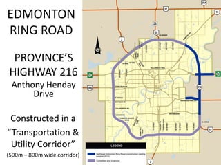
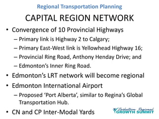
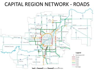
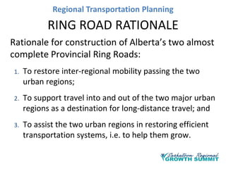
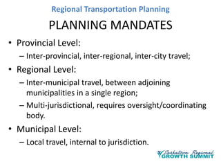
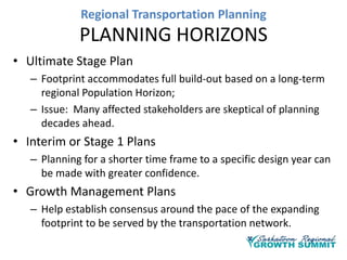
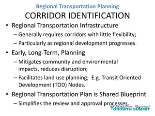
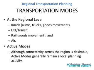
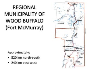
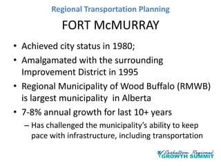
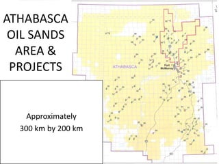
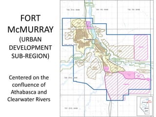
REGIONAL
TRANSPORTATION PLANNING
Henry Devos
Expert Advisor,
Senior Planning Specialist
CIMA+

Follow: @YXERegion #yxesummit
Regional Transportation Planning

OVERVIEW
• Saskatchewan & Saskatoon
– Expanding resource-based economy;
– Leading growth in population/employment levels;
– Expanding urban development; and
– Increasing traffic volumes.

• Similarities with Alberta’s experience
Regional Transportation Planning

OVERVIEW
• Reference largely to the Alberta Experience
– Successes,
– Challenges,
– Outstanding Issues?

• Consider Three Urban Regions
– Edmonton
Industrial/manufacturing
– Calgary
Business/financial
– Fort McMurray Resource/economic driver
Regional Transportation Planning

DEFINE THE REGION

Zones of Influence around a Major Urban Centre
Regional Transportation Planning

PLANNING MANDATES
• Provincial Level:
– Inter-provincial, inter-regional, inter-city travel;

• Regional Level:
– Inter-municipal travel, between adjoining
municipalities in a single region;
– Multi-jurisdictional, requires oversight/coordinating
body.

• Municipal Level:
– Local travel, internal to jurisdiction.
Regional Transportation Planning

PLANNING HORIZONS
• Ultimate Stage Plan
– Footprint accommodates full build-out based on a long-term
regional Population Horizon;
– Issue: Many affected stakeholders are skeptical of planning
decades ahead.

• Interim or Stage 1 Plans
– Planning for a shorter time frame to a specific design year can
be made with greater confidence.

• Growth Management Plans
– Help establish consensus around the pace of the expanding
footprint to be served by the transportation network.
Regional Transportation Planning

CORRIDOR IDENTIFICATION
• Regional Transportation Infrastructure
– Generally requires corridors with little flexibility;
– Particularly as regional development progresses.

• Early, Long-Term, Planning
– Mitigates community and environmental
impacts, reduces disruption;
– Facilitates land use planning; E.g. Transit Oriented
Development (TOD) Nodes.

• Regional Transportation Plan is Shared Blueprint
– Simplifies the review and approval processes.
Regional Transportation Planning

TRANSPORTATION MODES
• At the Regional Level
– Roads (autos, trucks, goods movement),
– LRT/Transit,
– Rail (goods movement), and
– Air.

• Active Modes
– Although connectivity across the region is desirable,
Active Modes generally remain a local planning
activity.
Regional Transportation Planning

SERVICE LEVELS
• Define performance goals for the regional
transportation facilities;
• A hierarchy of road (and transit) systems
providing different Levels-of-Service, Design
Speeds and Access Management.
– Freeways, expressways, collectors and local roads;
– LRT, Bus Rapid Transit, Express Bus, local service.

• Facilities that increasingly accommodate local
travel (short trips), tend to be less efficient,
have shorter service lives
Regional Transportation Planning

TECHNOLOGY
• User Fees:
–
–
–
–

Mileage Based (Highway 407 passing Toronto)
Cordon Tolls (Vancouver Area Bridges)
Time of Day or Congestion Based
Impact on mode choice, route choice, time-of-day

• Emerging Vehicle & System Technologies
– Autonomous Vehicles – Removing driver behaviour
– Connected Vehicles – To smart corridors
– Electric Vehicles

• Impact on long-term transportation plans and services
will vary by location.
Regional Transportation Planning
THE CAPITAL REGION

• 120 km east-west, Wabamun to Lamont
• 100 km north-south, Redwater to Millet
Regional Transportation Planning

CAPITAL REGION
• Alberta’s Primary Industrial/Manufacturing Base
– Supports the energy sector and Fort McMurray’s oil-sands;
– Manufacturing/employment centres are spread
throughout the Capital Region.

• Employment Distribution
– Past 10 years, 7% growth downtown, 20% in suburbs;
– One new office tower downtown every decade.

• Capital Region Board (CRB) Established in 2008
– Mandated by Province to oversee regional growth
management, macro-level transportation planning;
– CRB represents 24 municipalities, comprising 5 cities, 5
counties, 11 towns, 3 villages, 1.2 M people
Regional Transportation Planning

EDMONTON
RING ROAD

PROVINCE’S
HIGHWAY 216
Anthony Henday
Drive

Constructed in a
“Transportation &
Utility Corridor”
(500m – 800m wide corridor)
Regional Transportation Planning

CAPITAL REGION NETWORK
• Convergence of 10 Provincial Highways
– Primary link is Highway 2 to Calgary;
– Primary East-West link is Yellowhead Highway 16;
– Provincial Ring Road, Anthony Henday Drive; and
– Edmonton’s Inner Ring Road.

• Edmonton’s LRT network will become regional
• Edmonton International Airport
– Proposed ‘Port Alberta’, similar to Regina’s Global
Transportation Hub.

• CN and CP Inter-Modal Yards
Regional Transportation Planning
CAPITAL REGION NETWORK - ROADS
Regional Transportation Planning

RING ROAD RATIONALE
Rationale for construction of Alberta’s two almost
complete Provincial Ring Roads:
1.

To restore inter-regional mobility passing the two
urban regions;

2.

To support travel into and out of the two major urban
regions as a destination for long-distance travel; and

3.

To assist the two urban regions in restoring efficient
transportation systems, i.e. to help them grow.
Regional Transportation Planning
ALBERTA RING ROADS

POPULATION HORIZONS
Year

1965

1975

1985

1995

2005

2015

0

10

20

30

40

50

Capital Region Population

375,000

530,000

685,000

775,000

Calgary Region Population

310,000

460,000

650,000

785,000 1,030,000 1,270,000

Years Elapsed

910,000 1,100,000

Ring Road Activity
Scoping
Planning
Property Acquisition
Design & Construction



Scoping began when populations levels passed 300,000.



Construction began when population levels reached 750,000.



Nearing completion when population levels passed 1,200,000.
Regional EDMONTON LRT
CITY OFTransportation Planning
Regional Transportation Planning

EDMONTON LRT
• Recent route planning studies selected corridors
through established Edmonton communities
– Seen as intrusive in the short-term, controversial;

– Transformational in the long-term; new ‘highest &
best land uses’ will evolve (TOD).

• Classic Hub and Spoke design
– Good service to/from downtown and university;
– Perhaps less effective for the regional employment
centres.

• Potential to ultimately extend LRT to several
outlying municipalities
Regional Transportation Planning

CAPITAL REGION PLAN - TRANSIT
Regional Transportation Planning

REGIONAL
MUNICIPALITY OF
WOOD BUFFALO
(Fort McMurray)

Approximately:
• 520 km north-south
• 240 km east-west
Regional Transportation Planning

FORT McMURRAY
• Achieved city status in 1980;
• Amalgamated with the surrounding
Improvement District in 1995
• Regional Municipality of Wood Buffalo (RMWB)
is largest municipality in Alberta
• 7-8% annual growth for last 10+ years
– Has challenged the municipality’s ability to keep
pace with infrastructure, including transportation
Regional Transportation Planning

ATHABASCA
OIL SANDS
AREA &
PROJECTS

Approximately
300 km by 200 km
Regional Transportation Planning

FORT
McMURRAY
(URBAN
DEVELOPMENT
SUB-REGION)
Centered on the
confluence of
Athabasca and
Clearwater Rivers
Regional Transportation Planning

FORT McMURRAY – HIGHWAY 63
• Highway 63 is the municipality’s only North-South
corridor
• Passes through entire length of Fort McMurray
• Connects all neighbourhoods and resource
industries
• Queues and congestion have been legend at the
region’s only river crossing in downtown Fort
McMurray
• Province is upgrading the highway to urban
freeway standards
Regional Transportation Planning

FORT McMURRAY - INDUSTRY
• To reduce auto dependency/mitigate congestion,
Industry:
– Established bus services to the mine sites
– Continues to build camps/ lodges near the mine
sites, housing 1000’s of staff
– Established airfields near the plant sites, flying staff
in and out from around the country

• Fort McMurray airport is undergoing major
expansion
• Highly mobile labour force for the high-value
resource industries
Regional Transportation Planning

FORT McMURRAY - PARTNERING
• Province and RMWB are developing a corridor
management plan for Highway 63 through UDSR
• To Support the Expanding Bus Services:
– Province is passing legislation permitting designation of
special use lanes, Bus/HOV lanes, Bus-on-Shoulder
operations, etc.

• Province’s Transportation Coordinating Committee
includes RMWB and industry representatives
• Comprehensive Regional Infrastructure
Sustainability Plan (CRISP) jointly developed by
provincial agencies, industry and the RMWB
Regional Transportation Planning

CONCEPTUAL
Athabasca Oil
Sands Area
REGIONAL
NETWORK

Comprehensive
Regional
Infrastructure
Systems Plan (CRISP)
(Long-Term)
Regional Transportation Planning

CLOSING
The Right Honourable Adrienne Clarkson, from a
Globe & Mail article, September 26/13:
Commuting by car is not easy, and it takes so
much time. Why do we not have a public
transportation system, which goes ahead of
where we’re planning to have new communities?

THANK YOU

Regional Transportation Planning

  • 1.
    REGIONAL TRANSPORTATION PLANNING Henry Devos ExpertAdvisor, Senior Planning Specialist CIMA+ Follow: @YXERegion #yxesummit
  • 2.
    Regional Transportation Planning OVERVIEW •Saskatchewan & Saskatoon – Expanding resource-based economy; – Leading growth in population/employment levels; – Expanding urban development; and – Increasing traffic volumes. • Similarities with Alberta’s experience
  • 3.
    Regional Transportation Planning OVERVIEW •Reference largely to the Alberta Experience – Successes, – Challenges, – Outstanding Issues? • Consider Three Urban Regions – Edmonton Industrial/manufacturing – Calgary Business/financial – Fort McMurray Resource/economic driver
  • 4.
    Regional Transportation Planning DEFINETHE REGION Zones of Influence around a Major Urban Centre
  • 5.
    Regional Transportation Planning PLANNINGMANDATES • Provincial Level: – Inter-provincial, inter-regional, inter-city travel; • Regional Level: – Inter-municipal travel, between adjoining municipalities in a single region; – Multi-jurisdictional, requires oversight/coordinating body. • Municipal Level: – Local travel, internal to jurisdiction.
  • 6.
    Regional Transportation Planning PLANNINGHORIZONS • Ultimate Stage Plan – Footprint accommodates full build-out based on a long-term regional Population Horizon; – Issue: Many affected stakeholders are skeptical of planning decades ahead. • Interim or Stage 1 Plans – Planning for a shorter time frame to a specific design year can be made with greater confidence. • Growth Management Plans – Help establish consensus around the pace of the expanding footprint to be served by the transportation network.
  • 7.
    Regional Transportation Planning CORRIDORIDENTIFICATION • Regional Transportation Infrastructure – Generally requires corridors with little flexibility; – Particularly as regional development progresses. • Early, Long-Term, Planning – Mitigates community and environmental impacts, reduces disruption; – Facilitates land use planning; E.g. Transit Oriented Development (TOD) Nodes. • Regional Transportation Plan is Shared Blueprint – Simplifies the review and approval processes.
  • 8.
    Regional Transportation Planning TRANSPORTATIONMODES • At the Regional Level – Roads (autos, trucks, goods movement), – LRT/Transit, – Rail (goods movement), and – Air. • Active Modes – Although connectivity across the region is desirable, Active Modes generally remain a local planning activity.
  • 9.
    Regional Transportation Planning SERVICELEVELS • Define performance goals for the regional transportation facilities; • A hierarchy of road (and transit) systems providing different Levels-of-Service, Design Speeds and Access Management. – Freeways, expressways, collectors and local roads; – LRT, Bus Rapid Transit, Express Bus, local service. • Facilities that increasingly accommodate local travel (short trips), tend to be less efficient, have shorter service lives
  • 10.
    Regional Transportation Planning TECHNOLOGY •User Fees: – – – – Mileage Based (Highway 407 passing Toronto) Cordon Tolls (Vancouver Area Bridges) Time of Day or Congestion Based Impact on mode choice, route choice, time-of-day • Emerging Vehicle & System Technologies – Autonomous Vehicles – Removing driver behaviour – Connected Vehicles – To smart corridors – Electric Vehicles • Impact on long-term transportation plans and services will vary by location.
  • 11.
    Regional Transportation Planning THECAPITAL REGION • 120 km east-west, Wabamun to Lamont • 100 km north-south, Redwater to Millet
  • 12.
    Regional Transportation Planning CAPITALREGION • Alberta’s Primary Industrial/Manufacturing Base – Supports the energy sector and Fort McMurray’s oil-sands; – Manufacturing/employment centres are spread throughout the Capital Region. • Employment Distribution – Past 10 years, 7% growth downtown, 20% in suburbs; – One new office tower downtown every decade. • Capital Region Board (CRB) Established in 2008 – Mandated by Province to oversee regional growth management, macro-level transportation planning; – CRB represents 24 municipalities, comprising 5 cities, 5 counties, 11 towns, 3 villages, 1.2 M people
  • 13.
    Regional Transportation Planning EDMONTON RINGROAD PROVINCE’S HIGHWAY 216 Anthony Henday Drive Constructed in a “Transportation & Utility Corridor” (500m – 800m wide corridor)
  • 14.
    Regional Transportation Planning CAPITALREGION NETWORK • Convergence of 10 Provincial Highways – Primary link is Highway 2 to Calgary; – Primary East-West link is Yellowhead Highway 16; – Provincial Ring Road, Anthony Henday Drive; and – Edmonton’s Inner Ring Road. • Edmonton’s LRT network will become regional • Edmonton International Airport – Proposed ‘Port Alberta’, similar to Regina’s Global Transportation Hub. • CN and CP Inter-Modal Yards
  • 15.
  • 16.
    Regional Transportation Planning RINGROAD RATIONALE Rationale for construction of Alberta’s two almost complete Provincial Ring Roads: 1. To restore inter-regional mobility passing the two urban regions; 2. To support travel into and out of the two major urban regions as a destination for long-distance travel; and 3. To assist the two urban regions in restoring efficient transportation systems, i.e. to help them grow.
  • 17.
    Regional Transportation Planning ALBERTARING ROADS POPULATION HORIZONS Year 1965 1975 1985 1995 2005 2015 0 10 20 30 40 50 Capital Region Population 375,000 530,000 685,000 775,000 Calgary Region Population 310,000 460,000 650,000 785,000 1,030,000 1,270,000 Years Elapsed 910,000 1,100,000 Ring Road Activity Scoping Planning Property Acquisition Design & Construction  Scoping began when populations levels passed 300,000.  Construction began when population levels reached 750,000.  Nearing completion when population levels passed 1,200,000.
  • 18.
    Regional EDMONTON LRT CITYOFTransportation Planning
  • 19.
    Regional Transportation Planning EDMONTONLRT • Recent route planning studies selected corridors through established Edmonton communities – Seen as intrusive in the short-term, controversial; – Transformational in the long-term; new ‘highest & best land uses’ will evolve (TOD). • Classic Hub and Spoke design – Good service to/from downtown and university; – Perhaps less effective for the regional employment centres. • Potential to ultimately extend LRT to several outlying municipalities
  • 20.
  • 21.
    Regional Transportation Planning REGIONAL MUNICIPALITYOF WOOD BUFFALO (Fort McMurray) Approximately: • 520 km north-south • 240 km east-west
  • 22.
    Regional Transportation Planning FORTMcMURRAY • Achieved city status in 1980; • Amalgamated with the surrounding Improvement District in 1995 • Regional Municipality of Wood Buffalo (RMWB) is largest municipality in Alberta • 7-8% annual growth for last 10+ years – Has challenged the municipality’s ability to keep pace with infrastructure, including transportation
  • 23.
    Regional Transportation Planning ATHABASCA OILSANDS AREA & PROJECTS Approximately 300 km by 200 km
  • 24.
  • 25.
    Regional Transportation Planning FORTMcMURRAY – HIGHWAY 63 • Highway 63 is the municipality’s only North-South corridor • Passes through entire length of Fort McMurray • Connects all neighbourhoods and resource industries • Queues and congestion have been legend at the region’s only river crossing in downtown Fort McMurray • Province is upgrading the highway to urban freeway standards
  • 26.
    Regional Transportation Planning FORTMcMURRAY - INDUSTRY • To reduce auto dependency/mitigate congestion, Industry: – Established bus services to the mine sites – Continues to build camps/ lodges near the mine sites, housing 1000’s of staff – Established airfields near the plant sites, flying staff in and out from around the country • Fort McMurray airport is undergoing major expansion • Highly mobile labour force for the high-value resource industries
  • 27.
    Regional Transportation Planning FORTMcMURRAY - PARTNERING • Province and RMWB are developing a corridor management plan for Highway 63 through UDSR • To Support the Expanding Bus Services: – Province is passing legislation permitting designation of special use lanes, Bus/HOV lanes, Bus-on-Shoulder operations, etc. • Province’s Transportation Coordinating Committee includes RMWB and industry representatives • Comprehensive Regional Infrastructure Sustainability Plan (CRISP) jointly developed by provincial agencies, industry and the RMWB
  • 28.
    Regional Transportation Planning CONCEPTUAL AthabascaOil Sands Area REGIONAL NETWORK Comprehensive Regional Infrastructure Systems Plan (CRISP) (Long-Term)
  • 29.
    Regional Transportation Planning CLOSING TheRight Honourable Adrienne Clarkson, from a Globe & Mail article, September 26/13: Commuting by car is not easy, and it takes so much time. Why do we not have a public transportation system, which goes ahead of where we’re planning to have new communities? THANK YOU