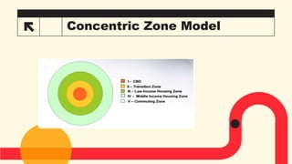
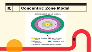
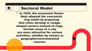
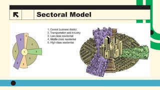
Grid and
Concentric
Model
Grid
Grid models are frameworks used to
organize, analyze, and visualize
relationships or systems in a
structured way, often using a two-
dimensional grid. These models are
common across different fields, such
as urban planning, computer
science, economics, and sociology,
where they help clarify patterns,
structures, or behaviors within
complex systems.
3
3
Grid
 In grid models, land is divided by
streets intersect at right angles,
forming a grid. Grid plans are more
common in North American cities than
in Europe, where older cities tend to
be build on streets that radiate out
from a central square or structure of
cultural significance.
4
Concentric Zone Model
is a theoretical model used in urban
sociology and human geography to
explain the spatial organization of
cities.
Developed by sociologist Ernest
Burgess in 1925, it describes how
urban areas grow and expand in a
series of concentric rings or zones
radiating out from a central point.
5
Concentric Zone Model
The model was based on
the study of Chicago and
was one of the first
systematic attempts to
explain urban social
structures and land use
patterns.
Concentric Zone Model
*
Concentric Zone Model
While foundational in urban sociology and
geography, has faced challenges in its
applicability to modern cities due to several
limitations. These challenges arise
primarily because the model, developed by
Ernest Burgess in the 1920s, was based on
early 20th-century urban development
patterns in industrial cities like Chicago.
Since then, cities have evolved in more
complex ways, making the model less
applicable in many contemporary contexts.
 Here are the key
reasons why the
Concentric Zone
Model has been
challenged:
1. Urban Growth and Modernization:
Decentralization and Suburbanization
Suburban Sprawl: refers to the uncontrolled,
low-density expansion of residential,
commercial, and industrial development into
rural or undeveloped areas on the outskirts
of cities. This phenomenon often results in
widespread, car-dependent communities
characterized by single-family homes, strip
malls, office parks, and large parking lots.
2. Transportation and Technology:
Automobile Dependency
Telecommunications and
Remote Work
3.Geographical Constraints and Variations:
Natural Features
Irregular Urban Patterns
4. Economic and Social Shifts:
Gentrification: refers to the process of
transforming urban neighborhoods,
typically low-income or working-class
areas, through an influx of more affluent
residents and businesses.
Decline of the CBD
5. Globalization and Immigration:
Ethnic Enclaves: The model assumes
that social classes and economic status
are the primary drivers of urban
structure. However, in many cities, ethnic
or immigrant communities form their own
distinct neighborhoods, which may not
follow the economic patterns predicted
by the model. These neighborhoods can
exist in various zones of the city, not just
in the "transitional zone" near the CBD.
5. Globalization and Immigration:
Global City Models: Many large,
global cities (New York,
London, Tokyo) do not follow
the simplistic pattern of the
concentric zone model. They
have complex, multi-centered
urban patterns driven by global
trade, finance, and immigration
that are more dynamic than the
model's structure.
6. Rise of the Multiple Nuclei Model and
Sector Model:
 Urban theorists like Harris and Ullman
developed the Multiple Nuclei Model to
explain how cities grow around multiple
centers of activity, such as business districts,
industrial areas, and residential zones.
Similarly, the Sector Model by Homer Hoyt
introduced the idea that urban growth often
occurs in sectors or wedges along
transportation routes rather than in
concentric rings.
 These alternative models provide a more
accurate explanation of the complexity of
modern urban development, making the
concentric zone model seem overly simplistic.
7. Applicability to Non-Western Cities:
 The concentric zone model is based on the
patterns observed in American industrial cities,
particularly Chicago in the early 20th century.
Its applicability to cities in other parts of the
world, especially in developing countries, is
limited. Cities in Africa, Asia, and Latin America
often have different growth patterns driven by
colonial histories, informal settlements, and
rapid urbanization, which do not conform to the
concentric ring pattern.
Therefore:
While the Concentric Zone Model was an
important early attempt to explain urban growth
and social organization, it has been increasingly
challenged by the complex, decentralized, and
multi-nucleated nature of modern cities. Factors
such as transportation, technology,
gentrification, globalization, and geographical
constraints make the model less relevant in
contemporary urban planning. However, it
remains a valuable starting point for
understanding historical urban growth patterns
and continues to influence urban geography
studies.
Sectoral Model
 In 1939, the economist Homer
Hoyt adapted the concentric
ring model by proposing
that cities develop in wedge-
shaped sectors instead of rings.
Certain areas of a city
are more attractive for various
activities, whether by chance or
geographic/environmental
reasons.
Sectoral Model
21
How we get there
ROI
• Envision multimedia-
based expertise and cross-
media growth strategies​
• Visualize
quality intellectual capital​
• Engage
worldwide methodologies
with web-enabled
technologies​
Niche markets
• Pursue scalable
customer service
through sustainable
strategies​
• Engage top-line
web services with
cutting-edge
deliverables
Supply chains
• Cultivate one-to-
one customer
service with robust
ideas​
• Maximize
timely deliverables
for real-
time schemas
Summary
At Contoso, we believe in giving 110%. By using
our next-generation data architecture, we help
organizations virtually manage agile workflows.
We thrive because of our market knowledge and
great team behind our product. As our CEO says,
"Efficiencies will come from proactively
transforming how we do business."​
​
Thank
you!

GRID AND CONCENTRIC ZONE MODEL POWERPOINT PRESENTATION

  • 1.
  • 2.
    Grid Grid models areframeworks used to organize, analyze, and visualize relationships or systems in a structured way, often using a two- dimensional grid. These models are common across different fields, such as urban planning, computer science, economics, and sociology, where they help clarify patterns, structures, or behaviors within complex systems. 3 3
  • 3.
    Grid  In gridmodels, land is divided by streets intersect at right angles, forming a grid. Grid plans are more common in North American cities than in Europe, where older cities tend to be build on streets that radiate out from a central square or structure of cultural significance. 4
  • 4.
    Concentric Zone Model isa theoretical model used in urban sociology and human geography to explain the spatial organization of cities. Developed by sociologist Ernest Burgess in 1925, it describes how urban areas grow and expand in a series of concentric rings or zones radiating out from a central point. 5
  • 5.
    Concentric Zone Model Themodel was based on the study of Chicago and was one of the first systematic attempts to explain urban social structures and land use patterns.
  • 6.
  • 7.
  • 8.
    Concentric Zone Model Whilefoundational in urban sociology and geography, has faced challenges in its applicability to modern cities due to several limitations. These challenges arise primarily because the model, developed by Ernest Burgess in the 1920s, was based on early 20th-century urban development patterns in industrial cities like Chicago. Since then, cities have evolved in more complex ways, making the model less applicable in many contemporary contexts.
  • 9.
     Here arethe key reasons why the Concentric Zone Model has been challenged:
  • 10.
    1. Urban Growthand Modernization: Decentralization and Suburbanization Suburban Sprawl: refers to the uncontrolled, low-density expansion of residential, commercial, and industrial development into rural or undeveloped areas on the outskirts of cities. This phenomenon often results in widespread, car-dependent communities characterized by single-family homes, strip malls, office parks, and large parking lots.
  • 11.
    2. Transportation andTechnology: Automobile Dependency Telecommunications and Remote Work
  • 12.
    3.Geographical Constraints andVariations: Natural Features Irregular Urban Patterns
  • 13.
    4. Economic andSocial Shifts: Gentrification: refers to the process of transforming urban neighborhoods, typically low-income or working-class areas, through an influx of more affluent residents and businesses. Decline of the CBD
  • 14.
    5. Globalization andImmigration: Ethnic Enclaves: The model assumes that social classes and economic status are the primary drivers of urban structure. However, in many cities, ethnic or immigrant communities form their own distinct neighborhoods, which may not follow the economic patterns predicted by the model. These neighborhoods can exist in various zones of the city, not just in the "transitional zone" near the CBD.
  • 15.
    5. Globalization andImmigration: Global City Models: Many large, global cities (New York, London, Tokyo) do not follow the simplistic pattern of the concentric zone model. They have complex, multi-centered urban patterns driven by global trade, finance, and immigration that are more dynamic than the model's structure.
  • 16.
    6. Rise ofthe Multiple Nuclei Model and Sector Model:  Urban theorists like Harris and Ullman developed the Multiple Nuclei Model to explain how cities grow around multiple centers of activity, such as business districts, industrial areas, and residential zones. Similarly, the Sector Model by Homer Hoyt introduced the idea that urban growth often occurs in sectors or wedges along transportation routes rather than in concentric rings.  These alternative models provide a more accurate explanation of the complexity of modern urban development, making the concentric zone model seem overly simplistic.
  • 17.
    7. Applicability toNon-Western Cities:  The concentric zone model is based on the patterns observed in American industrial cities, particularly Chicago in the early 20th century. Its applicability to cities in other parts of the world, especially in developing countries, is limited. Cities in Africa, Asia, and Latin America often have different growth patterns driven by colonial histories, informal settlements, and rapid urbanization, which do not conform to the concentric ring pattern.
  • 18.
    Therefore: While the ConcentricZone Model was an important early attempt to explain urban growth and social organization, it has been increasingly challenged by the complex, decentralized, and multi-nucleated nature of modern cities. Factors such as transportation, technology, gentrification, globalization, and geographical constraints make the model less relevant in contemporary urban planning. However, it remains a valuable starting point for understanding historical urban growth patterns and continues to influence urban geography studies.
  • 19.
    Sectoral Model  In1939, the economist Homer Hoyt adapted the concentric ring model by proposing that cities develop in wedge- shaped sectors instead of rings. Certain areas of a city are more attractive for various activities, whether by chance or geographic/environmental reasons.
  • 20.
  • 21.
    How we getthere ROI • Envision multimedia- based expertise and cross- media growth strategies​ • Visualize quality intellectual capital​ • Engage worldwide methodologies with web-enabled technologies​ Niche markets • Pursue scalable customer service through sustainable strategies​ • Engage top-line web services with cutting-edge deliverables Supply chains • Cultivate one-to- one customer service with robust ideas​ • Maximize timely deliverables for real- time schemas
  • 22.
    Summary At Contoso, webelieve in giving 110%. By using our next-generation data architecture, we help organizations virtually manage agile workflows. We thrive because of our market knowledge and great team behind our product. As our CEO says, "Efficiencies will come from proactively transforming how we do business."​ ​
  • 23.

Editor's Notes

  • #4 - Grid plans facilitate development because developers can subdivide and auction off large parcels of land. -The geometry yields regular lots that maximize use and minimize boundary disputes. However, grids can be dangerous because long, straight roads allow faster automobile traffic. In the 1960s, urban planners moved away from grids and began planning suburban developments with dead ends and cul-de-sacs. Dead ends and cul-de-sacs are both types of street layouts commonly found in residential areas, but they differ slightly in their purpose and design. 1. Dead End: Definition: A dead end is a road or street with only one entry/exit point, meaning it terminates abruptly with no outlet for through traffic. Purpose: Typically, dead ends are unintentional or the result of unfinished development. They may also occur where further construction was planned but abandoned, leaving the road without a continuation. Characteristics: No turnaround area; vehicles must reverse or make tight turns to leave. May not be designed with pedestrian or vehicle circulation in mind. Example: A road in a new housing development that hasn’t been extended due to halted construction. 2. Cul-de-Sac: Definition: A cul-de-sac is a street that also has only one entry/exit point but ends in a circular or bulb-shaped turnaround area, designed specifically to allow vehicles to turn around easily. Purpose: Cul-de-sacs are intentionally designed to create quiet, low-traffic residential environments. They discourage through traffic and provide a safe, private space for residents, often favored by families for their reduced traffic flow and safety. Characteristics: Designed turnaround area, typically circular or semi-circular. Encourages slower traffic, making it safer for pedestrians. Often associated with suburban residential planning. Example: A suburban street that ends in a wide, circular area where cars can easily turn around. Comparison: Traffic Flow: Both dead ends and cul-de-sacs limit through traffic, but cul-de-sacs are designed for ease of movement within the confined space, while dead ends may not have provisions for turning around. Design Intent: Dead ends are often the result of incomplete or unintended road designs, whereas cul-de-sacs are deliberately designed for safety and tranquility. Vehicle Movement: A cul-de-sac allows vehicles to turn around easily due to its circular design, while dead ends may require more effort for drivers to reverse or maneuver out. Conclusion: While both dead ends and cul-de-sacs are streets that do not connect to another roadway, cul-de-sacs are more purposefully designed with safety and convenience in mind, offering a structured turnaround space. Dead ends, by contrast, often arise due to unfinished development or unintentional design and may not provide the same ease of movement or residential appeal.
  • #6 -The concentric ring model was postulated in 1924 by sociologist Ernest Burgess, based on his observations of Chicago. It draws on human ecology theories, which compared the city to an ecosystem, with processes of adaptation and assimilation. -Urban residents naturally sort themselves into appropriate rings, or ecological niches, depending on class and cultural assimilation. Class Assimilation: Class assimilation refers to the process by which individuals or groups move from one social class to another, often from a lower to a higher class. This involves changes in income, education, occupation, lifestyle, and social mobility. Examples: A first-generation college graduate from a low-income family who becomes a lawyer, gaining entry into the professional middle class. Immigrants who start with low-income jobs but gradually climb the social ladder through entrepreneurship, education, or skill development. Cultural Assimilation: Cultural assimilation occurs when a minority group or individual adopts the customs, language, and cultural norms of a dominant or mainstream culture, often to fit in or avoid marginalization. Over time, this can lead to the reduction of distinct cultural identities as people blend into the dominant culture. Examples: Immigrants adopting the culture, language, and customs of their new country, such as speaking English and celebrating national holidays like Thanksgiving in the U.S. Indigenous populations in colonized regions being forced or incentivized to adopt the language and religion of the colonizers.
  • #8 -The innermost ring represents the, central business district (CBD), called Zone A. -It is surrounded by a zone of transition (B), which contains industry and poorer-quality housing. -The third ring (C) contains housing for the working-class—the zone of independent workers’ homes. -The fourth ring (D) has newer and larger houses occupied by the middle-class. -The outermost ring(E), or commuter’s zone, is residential suburbs. Structure of the Concentric Zone Model: Zone 1: Central Business District (CBD): The innermost circle or the "heart" of the city. Characterized by high-density commercial activity, including businesses, financial institutions, and government buildings. Land here is expensive and densely built up, with very few residential areas. Zone 2: Transitional Zone: Surrounding the CBD, this zone is an area of transition from commercial to residential use. Often includes older, deteriorating housing, light industry, and a mix of small businesses. This zone typically houses low-income residents, including recent immigrants or those displaced by urban development. It is often associated with poverty, crime, and social instability. Burgess referred to this area as prone to decay and called it a "zone of deterioration." Zone 3: Working-Class Residential Zone: Known as the "inner suburbs" or low-income residential area. Home to the working-class population who desire proximity to work opportunities in the city center. This zone is made up of modest, older homes and apartments where people live in close-knit communities, often those employed in industrial and manual labor jobs. Zone 4: Middle-Class Residential Zone: Suburban area with larger homes and more green spaces. Occupied by middle-class families, professionals, and white-collar workers who seek more space and better living conditions while still being close enough to commute to the city center. Housing in this area tends to be newer and better maintained than in the working-class zone. Zone 5: Commuter Zone: The outermost ring, also called the "exurbs" or "commuter zone." Characterized by low-density residential areas, large houses, and more affluent communities. Residents in this zone typically commute to the city for work but live in suburban or semi-rural settings where they enjoy a quieter and more spacious lifestyle. This zone marks the transition from urban to rural land use.
  • #11 Here are the key reasons why the Concentric Zone Model has been challenged: 1. Urban Growth and Modernization: Decentralization and Suburbanization: Modern cities have seen significant decentralization, where businesses, shopping centers, and residential areas have moved away from the central business district (CBD) to the suburbs and beyond. This results in the rise of edge cities (secondary business districts) and multiple nuclei of development, which the concentric zone model does not account for. Suburban Sprawl: Suburbs often grow in irregular patterns, influenced by highways, green spaces, and existing infrastructure, rather than in uniform concentric rings. The outward sprawl of cities doesn't fit the neat ring-shaped zones described in the model. Decentralization and suburbanization are two interconnected processes that describe the outward movement of people, businesses, and industries from city centers to peripheral areas. Both have significantly shaped the way modern cities develop, leading to changes in population distribution, economic activities, and urban landscapes. Decentralization: Decentralization refers to the process where activities, services, and governance that were once concentrated in a city center (central business district or CBD) are dispersed to outlying areas. It involves the redistribution of population and businesses from the urban core to the suburbs, exurbs, and other peripheral areas. Suburbanization: Suburbanization is a specific aspect of decentralization that focuses on the growth and expansion of suburbs—residential communities located on the outskirts of cities. It refers to the movement of people from the city center to surrounding suburban areas, often driven by the desire for larger homes, quieter environments, and better access to schools and amenities.
  • #12 Transportation and Technology: Automobile Dependency: The widespread use of cars has changed how cities are organized. People are no longer as dependent on living close to their workplace (in the city center) because they can commute from distant suburban or even exurban areas. This has led to the emergence of sprawling commuter towns that challenge the idea of spatial organization around a central CBD. Telecommunications and Remote Work: With the rise of technology, telecommuting and remote work have reduced the necessity of living close to urban centers. This further challenges the assumption that economic and social life is concentrated in the CBD.
  • #13 3. Geographical Constraints and Variations: Natural Features: The model assumes a flat, featureless landscape, but real cities are often shaped by geographical constraints such as rivers, mountains, and coastlines. These features disrupt the concentric ring structure by concentrating development in certain areas while leaving others less developed. Irregular Urban Patterns: Cities often grow along transportation routes like highways or railroads, creating a more linear or sector-based pattern of growth. This contradicts the circular zones of the model.
  • #14 GENTRIFICATION: the process whereby the character of a poor urban area is changed by wealthier people moving in, improving housing, and attracting new businesses, typically displacing current inhabitants in the process. Gentrification refers to the process of transforming urban neighborhoods, typically low-income or working-class areas, through an influx of more affluent residents and businesses. While this process can lead to neighborhood revitalization, improved infrastructure, and economic growth, it often has negative consequences, such as the displacement of long-time, lower-income residents and the erosion of the neighborhood’s original culture. 4. Economic and Social Shifts: Gentrification: Gentrification, where wealthier people move into previously low-income or working-class areas near the city center, has reversed some of the model’s assumptions. The model suggests that the inner zones near the CBD are poorer and more industrial, but many modern cities experience an influx of wealth and investment in these areas, leading to rising property values and displacement of lower-income residents. Decline of the CBD: In many cities, the traditional central business district has declined as businesses relocate to suburban office parks or secondary business centers. This challenges the model's core assumption that the CBD is the dominant economic hub of the city.