SlideShare a Scribd company logo
1 of 1
Download to read offline
Overview Data Access SystemData Integration
Timeline
TERRA POPULUS
A Global Population/Environment Data Network
Terra Populus (TerraPop) provides global-scale
data on human population characteristics, land
use, land cover, and climate change. The data are
integrated across time and space, made available
to researchers and the public, and preserved for
future generations.
The TerraPop data access system allows users to
easily obtain customized datasets incorporating
information from a variety of population and
environmental data sources into an integrated
package tailored to meet the users’ needs.
Partners
Tabulate population
characteristics of administrative
units from microdata
Attach characteristics of administrative units
to person or household records
Distribute properties
of polygons to
grid cells
Calculate totals,
means, and other
summaries of gridded
variables within
polygons
Attach contextual data
from rasters to person
or household records
Tabulate
population
characteristics of
administrative units
from microdata and
distribute over a
spatial grid
Restricted access beta
testing
Summer – Fall
2013
Public beta Late 2013
TerraPop 1.0 Spring 2014
What is raster data? Available in TerraPop 1.0 Future additions
Spatial grids in which each grid cell
contains the value of a variable at that
location.
• Global land cover (GLC 2000)
• Global temperature and
precipitation (WorldClim)
• Global harvested area and yield for
175 crops
• Additional land cover and climate
datasets
• Elevation
• Vegetation characteristics
• Gridded Population of the World
• Global Rural-Urban Mapping
Project
• Bioclimatic/ecological zones
What is microdata?
Available in TerraPop
Future additions
Census records for individuals
and households
200+ censuses from 70+ countries,
with more censuses added each year
• Household relationships
• Fertility and mortality
• Migration
• Education and work
• Utilities and amenities
• Economics
• Dwelling characteristics
What is area-level
data?
Available in TerraPop 1.0
Data about places defined
by boundaries
Population summaries
• Basic demographics
• Education
• Employment
• Household utilities &
amenities
Additional boundaries
• More lower-level
administrative units
• Watersheds
Administrative units
• First-level (e.g. states) in most countries
• Second-level (e.g. counties) in several
countries
• Current, historical, and harmonized
• Economics
• Health
• Legal and policy
• Agriculture
Location-Based Integration
TerraPop leverages geographic properties to
integrate information from datasets in multiple
data structures to generate customized,
integrated datasets for users. Users can mix and
match variables originating in raster, area-level,
and/or microdata datasets, and obtain output
in whichever of the three structures best meets
their needs. The TerraPop system uses
information about the location of each record
in the original data to attach contextual
information, generate spatial summaries, or
assign values to points, depending on the
transformation requested.
Browse Variables and Metadata
Select Variables and Datasets
Choose Output Structure
Define Output Options
Get Data!
Browse variables in a variety of topics and
view basic availability information
Easily access more detailed metadata
about each variable
Many variables, especially from census
data, appear in multiple datasets, so you
must specify the datasets from which you
want data.
Selections appear in your data cart
Depending on the variables in your
cart, you can choose area-level,
microdata, or raster output
Depending on the type of output you
choose, you may need to select additional
options, such as geographic level or
operations to summarize raster data to
administrative units.
You will receive an e-mail when your customized dataset
is ready to download.Funding provided by NSF Award OCI-0940818

More Related Content

What's hot

041018 Esds Poster
041018 Esds Poster041018 Esds Poster
041018 Esds PosterRudolf Husar
 
061211 Agu Aq Datasystem1
061211 Agu Aq Datasystem1061211 Agu Aq Datasystem1
061211 Agu Aq Datasystem1Rudolf Husar
 
060525AGU_ESSI CAPITA Poster
060525AGU_ESSI CAPITA Poster060525AGU_ESSI CAPITA Poster
060525AGU_ESSI CAPITA PosterRudolf Husar
 
060730 Igarss06 Denver Husar
060730 Igarss06 Denver Husar060730 Igarss06 Denver Husar
060730 Igarss06 Denver HusarRudolf Husar
 
Metadata Standards in CKAN for Biodiversity Pilot in NextGEOSS
Metadata Standards in CKAN for Biodiversity Pilot in NextGEOSSMetadata Standards in CKAN for Biodiversity Pilot in NextGEOSS
Metadata Standards in CKAN for Biodiversity Pilot in NextGEOSSplan4all
 
The Climateprediction.net programme, big data climate modelling
The Climateprediction.net programme, big data climate modellingThe Climateprediction.net programme, big data climate modelling
The Climateprediction.net programme, big data climate modellingDavid Wallom
 
Web Services Emissions 2006 Falke
Web Services Emissions 2006 FalkeWeb Services Emissions 2006 Falke
Web Services Emissions 2006 FalkeRudolf Husar
 
Implementation of RS-EBVs in Habitat Modelling
Implementation of RS-EBVs in Habitat ModellingImplementation of RS-EBVs in Habitat Modelling
Implementation of RS-EBVs in Habitat Modellingplan4all
 
2004-09-12 Data and Tools for Air Quality Management:
2004-09-12 Data and Tools for Air Quality Management:2004-09-12 Data and Tools for Air Quality Management:
2004-09-12 Data and Tools for Air Quality Management:Rudolf Husar
 
Provenance Aware Linked Sensor Data
Provenance Aware Linked Sensor DataProvenance Aware Linked Sensor Data
Provenance Aware Linked Sensor DataHarshal Patni
 
Improvement of Spatial Data Quality Using the Data Conflation
Improvement of Spatial Data Quality Using the Data ConflationImprovement of Spatial Data Quality Using the Data Conflation
Improvement of Spatial Data Quality Using the Data ConflationBeniamino Murgante
 
Potential OASIS Geothermal Energy standards project
Potential OASIS Geothermal Energy standards projectPotential OASIS Geothermal Energy standards project
Potential OASIS Geothermal Energy standards projectJamie Clark
 
060128 Galeon Rept
060128 Galeon Rept060128 Galeon Rept
060128 Galeon ReptRudolf Husar
 

What's hot (20)

041018 Esds Poster
041018 Esds Poster041018 Esds Poster
041018 Esds Poster
 
061211 Agu Aq Datasystem1
061211 Agu Aq Datasystem1061211 Agu Aq Datasystem1
061211 Agu Aq Datasystem1
 
060525AGU_ESSI CAPITA Poster
060525AGU_ESSI CAPITA Poster060525AGU_ESSI CAPITA Poster
060525AGU_ESSI CAPITA Poster
 
060730 Igarss06 Denver Husar
060730 Igarss06 Denver Husar060730 Igarss06 Denver Husar
060730 Igarss06 Denver Husar
 
Metadata Standards in CKAN for Biodiversity Pilot in NextGEOSS
Metadata Standards in CKAN for Biodiversity Pilot in NextGEOSSMetadata Standards in CKAN for Biodiversity Pilot in NextGEOSS
Metadata Standards in CKAN for Biodiversity Pilot in NextGEOSS
 
The Climateprediction.net programme, big data climate modelling
The Climateprediction.net programme, big data climate modellingThe Climateprediction.net programme, big data climate modelling
The Climateprediction.net programme, big data climate modelling
 
Web Services Emissions 2006 Falke
Web Services Emissions 2006 FalkeWeb Services Emissions 2006 Falke
Web Services Emissions 2006 Falke
 
Implementation of RS-EBVs in Habitat Modelling
Implementation of RS-EBVs in Habitat ModellingImplementation of RS-EBVs in Habitat Modelling
Implementation of RS-EBVs in Habitat Modelling
 
Dataset Independent Subsetting
Dataset Independent SubsettingDataset Independent Subsetting
Dataset Independent Subsetting
 
2004-09-12 Data and Tools for Air Quality Management:
2004-09-12 Data and Tools for Air Quality Management:2004-09-12 Data and Tools for Air Quality Management:
2004-09-12 Data and Tools for Air Quality Management:
 
Linked Sensor Data
Linked Sensor DataLinked Sensor Data
Linked Sensor Data
 
Provenance Aware Linked Sensor Data
Provenance Aware Linked Sensor DataProvenance Aware Linked Sensor Data
Provenance Aware Linked Sensor Data
 
Iccsa stankuteha180611
Iccsa stankuteha180611Iccsa stankuteha180611
Iccsa stankuteha180611
 
Improvement of Spatial Data Quality Using the Data Conflation
Improvement of Spatial Data Quality Using the Data ConflationImprovement of Spatial Data Quality Using the Data Conflation
Improvement of Spatial Data Quality Using the Data Conflation
 
Potential OASIS Geothermal Energy standards project
Potential OASIS Geothermal Energy standards projectPotential OASIS Geothermal Energy standards project
Potential OASIS Geothermal Energy standards project
 
Predicting Plant Growth
Predicting Plant GrowthPredicting Plant Growth
Predicting Plant Growth
 
Application of web ontology to harvest estimation of rice in thailand
Application of web ontology to harvest estimation of rice in thailandApplication of web ontology to harvest estimation of rice in thailand
Application of web ontology to harvest estimation of rice in thailand
 
Application of web ontology to harvest estimation of rice in Thailand
Application of web ontology to harvest estimation of rice in ThailandApplication of web ontology to harvest estimation of rice in Thailand
Application of web ontology to harvest estimation of rice in Thailand
 
060128 Galeon Rept
060128 Galeon Rept060128 Galeon Rept
060128 Galeon Rept
 
Real Time Semantic Analysis of Streaming Sensor Data
Real Time Semantic Analysis of Streaming Sensor DataReal Time Semantic Analysis of Streaming Sensor Data
Real Time Semantic Analysis of Streaming Sensor Data
 

Viewers also liked (10)

Terra Populus Overview
Terra Populus OverviewTerra Populus Overview
Terra Populus Overview
 
TerraPop Brief Overview (2 slides)
TerraPop Brief Overview (2 slides)TerraPop Brief Overview (2 slides)
TerraPop Brief Overview (2 slides)
 
Recomendaciones del Consejo Europeo a España
Recomendaciones del Consejo Europeo a EspañaRecomendaciones del Consejo Europeo a España
Recomendaciones del Consejo Europeo a España
 
5
55
5
 
Practice Hunting
Practice HuntingPractice Hunting
Practice Hunting
 
Lightning Talk #9: How UX and Data Storytelling Can Shape Policy by Mika Aldaba
Lightning Talk #9: How UX and Data Storytelling Can Shape Policy by Mika AldabaLightning Talk #9: How UX and Data Storytelling Can Shape Policy by Mika Aldaba
Lightning Talk #9: How UX and Data Storytelling Can Shape Policy by Mika Aldaba
 
Minnesota Data Harmonization Projects
Minnesota Data Harmonization ProjectsMinnesota Data Harmonization Projects
Minnesota Data Harmonization Projects
 
Succession “Losers”: What Happens to Executives Passed Over for the CEO Job?
Succession “Losers”: What Happens to Executives Passed Over for the CEO Job? Succession “Losers”: What Happens to Executives Passed Over for the CEO Job?
Succession “Losers”: What Happens to Executives Passed Over for the CEO Job?
 
Cervical cancer ppt
Cervical cancer pptCervical cancer ppt
Cervical cancer ppt
 
SEO: Getting Personal
SEO: Getting PersonalSEO: Getting Personal
SEO: Getting Personal
 

Similar to Terra Populus Overview Poster

Terra Populus: Integrated Data on Population and Environment
Terra Populus: Integrated Data on Population and EnvironmentTerra Populus: Integrated Data on Population and Environment
Terra Populus: Integrated Data on Population and EnvironmentAPLICwebmaster
 
Geospatial metadata and spatial data workshop: 19 June 2014
Geospatial metadata and spatial data workshop: 19 June 2014Geospatial metadata and spatial data workshop: 19 June 2014
Geospatial metadata and spatial data workshop: 19 June 2014EDINA, University of Edinburgh
 
What to do with the existing spatial data in planning
What to do with the existing spatial data in planningWhat to do with the existing spatial data in planning
What to do with the existing spatial data in planningKarel Charvat
 
How TERN Data Infrastructure works
How TERN Data Infrastructure worksHow TERN Data Infrastructure works
How TERN Data Infrastructure worksTERN Australia
 
The Tropical Rain Forest Information Center
The Tropical Rain Forest Information CenterThe Tropical Rain Forest Information Center
The Tropical Rain Forest Information CenterRudolf Husar
 
Next-Generation Search Engines for Information Retrieval
Next-Generation Search Engines for Information RetrievalNext-Generation Search Engines for Information Retrieval
Next-Generation Search Engines for Information RetrievalWaqas Tariq
 
RDAP14: David Van Riper of Terra Populus
RDAP14: David Van Riper of Terra Populus RDAP14: David Van Riper of Terra Populus
RDAP14: David Van Riper of Terra Populus ASIS&T
 
Urm concept for sharing information inside of communities
Urm concept for sharing information inside of communitiesUrm concept for sharing information inside of communities
Urm concept for sharing information inside of communitiesKarel Charvat
 
Dats nih-dccpc-kc7-april2018-prs-uoxf
Dats  nih-dccpc-kc7-april2018-prs-uoxfDats  nih-dccpc-kc7-april2018-prs-uoxf
Dats nih-dccpc-kc7-april2018-prs-uoxfPhilippe Rocca-Serra
 
Northumbria University Geospatial Metadata Workshop 20110505
Northumbria University Geospatial Metadata Workshop 20110505Northumbria University Geospatial Metadata Workshop 20110505
Northumbria University Geospatial Metadata Workshop 20110505EDINA, University of Edinburgh
 
Maximize the value of Earth Observation Data in a Big Data World
Maximize the value of Earth Observation Data in a Big Data WorldMaximize the value of Earth Observation Data in a Big Data World
Maximize the value of Earth Observation Data in a Big Data WorldBYTE Project
 
Open Tenure and STDM
Open Tenure and STDMOpen Tenure and STDM
Open Tenure and STDMFAO
 
Semantic data integration proof of concept
Semantic data integration proof of conceptSemantic data integration proof of concept
Semantic data integration proof of conceptNicolas Bertrand
 
Conflation, Data Quality and MADness (David Smith)
Conflation, Data Quality and MADness (David Smith)Conflation, Data Quality and MADness (David Smith)
Conflation, Data Quality and MADness (David Smith)geeknixta
 
Oxford University Geospatial Metadata Workshop 20110415
Oxford University Geospatial Metadata Workshop 20110415Oxford University Geospatial Metadata Workshop 20110415
Oxford University Geospatial Metadata Workshop 20110415EDINA, University of Edinburgh
 

Similar to Terra Populus Overview Poster (20)

Terra Populus: Integrated Data on Population and Environment
Terra Populus: Integrated Data on Population and EnvironmentTerra Populus: Integrated Data on Population and Environment
Terra Populus: Integrated Data on Population and Environment
 
Geospatial metadata and spatial data workshop: 19 June 2014
Geospatial metadata and spatial data workshop: 19 June 2014Geospatial metadata and spatial data workshop: 19 June 2014
Geospatial metadata and spatial data workshop: 19 June 2014
 
What to do with the existing spatial data in planning
What to do with the existing spatial data in planningWhat to do with the existing spatial data in planning
What to do with the existing spatial data in planning
 
How TERN Data Infrastructure works
How TERN Data Infrastructure worksHow TERN Data Infrastructure works
How TERN Data Infrastructure works
 
Semantics-enhanced Geoscience Interoperability, Analytics, and Applications
Semantics-enhanced Geoscience Interoperability, Analytics, and ApplicationsSemantics-enhanced Geoscience Interoperability, Analytics, and Applications
Semantics-enhanced Geoscience Interoperability, Analytics, and Applications
 
The Tropical Rain Forest Information Center
The Tropical Rain Forest Information CenterThe Tropical Rain Forest Information Center
The Tropical Rain Forest Information Center
 
Next-Generation Search Engines for Information Retrieval
Next-Generation Search Engines for Information RetrievalNext-Generation Search Engines for Information Retrieval
Next-Generation Search Engines for Information Retrieval
 
RDAP14: David Van Riper of Terra Populus
RDAP14: David Van Riper of Terra Populus RDAP14: David Van Riper of Terra Populus
RDAP14: David Van Riper of Terra Populus
 
Urm concept for sharing information inside of communities
Urm concept for sharing information inside of communitiesUrm concept for sharing information inside of communities
Urm concept for sharing information inside of communities
 
Dats nih-dccpc-kc7-april2018-prs-uoxf
Dats  nih-dccpc-kc7-april2018-prs-uoxfDats  nih-dccpc-kc7-april2018-prs-uoxf
Dats nih-dccpc-kc7-april2018-prs-uoxf
 
Dynamic Integrations of Crop Data and Corresponding Meteorological Data based...
Dynamic Integrations of Crop Data and Corresponding Meteorological Data based...Dynamic Integrations of Crop Data and Corresponding Meteorological Data based...
Dynamic Integrations of Crop Data and Corresponding Meteorological Data based...
 
Dynamic integrations of crop data and corresponding meteorological data based...
Dynamic integrations of crop data and corresponding meteorological data based...Dynamic integrations of crop data and corresponding meteorological data based...
Dynamic integrations of crop data and corresponding meteorological data based...
 
Northumbria University Geospatial Metadata Workshop 20110505
Northumbria University Geospatial Metadata Workshop 20110505Northumbria University Geospatial Metadata Workshop 20110505
Northumbria University Geospatial Metadata Workshop 20110505
 
Maximize the value of Earth Observation Data in a Big Data World
Maximize the value of Earth Observation Data in a Big Data WorldMaximize the value of Earth Observation Data in a Big Data World
Maximize the value of Earth Observation Data in a Big Data World
 
Open Tenure and STDM
Open Tenure and STDMOpen Tenure and STDM
Open Tenure and STDM
 
Semantic data integration proof of concept
Semantic data integration proof of conceptSemantic data integration proof of concept
Semantic data integration proof of concept
 
ESRI DevMeetup 201100607
ESRI DevMeetup 201100607ESRI DevMeetup 201100607
ESRI DevMeetup 201100607
 
Conflation, Data Quality and MADness (David Smith)
Conflation, Data Quality and MADness (David Smith)Conflation, Data Quality and MADness (David Smith)
Conflation, Data Quality and MADness (David Smith)
 
agriopenlink - summary
agriopenlink  - summary agriopenlink  - summary
agriopenlink - summary
 
Oxford University Geospatial Metadata Workshop 20110415
Oxford University Geospatial Metadata Workshop 20110415Oxford University Geospatial Metadata Workshop 20110415
Oxford University Geospatial Metadata Workshop 20110415
 

Recently uploaded

Procuring digital preservation CAN be quick and painless with our new dynamic...
Procuring digital preservation CAN be quick and painless with our new dynamic...Procuring digital preservation CAN be quick and painless with our new dynamic...
Procuring digital preservation CAN be quick and painless with our new dynamic...Jisc
 
Keynote by Prof. Wurzer at Nordex about IP-design
Keynote by Prof. Wurzer at Nordex about IP-designKeynote by Prof. Wurzer at Nordex about IP-design
Keynote by Prof. Wurzer at Nordex about IP-designMIPLM
 
Field Attribute Index Feature in Odoo 17
Field Attribute Index Feature in Odoo 17Field Attribute Index Feature in Odoo 17
Field Attribute Index Feature in Odoo 17Celine George
 
Roles & Responsibilities in Pharmacovigilance
Roles & Responsibilities in PharmacovigilanceRoles & Responsibilities in Pharmacovigilance
Roles & Responsibilities in PharmacovigilanceSamikshaHamane
 
Visit to a blind student's school🧑‍🦯🧑‍🦯(community medicine)
Visit to a blind student's school🧑‍🦯🧑‍🦯(community medicine)Visit to a blind student's school🧑‍🦯🧑‍🦯(community medicine)
Visit to a blind student's school🧑‍🦯🧑‍🦯(community medicine)lakshayb543
 
Gas measurement O2,Co2,& ph) 04/2024.pptx
Gas measurement O2,Co2,& ph) 04/2024.pptxGas measurement O2,Co2,& ph) 04/2024.pptx
Gas measurement O2,Co2,& ph) 04/2024.pptxDr.Ibrahim Hassaan
 
Karra SKD Conference Presentation Revised.pptx
Karra SKD Conference Presentation Revised.pptxKarra SKD Conference Presentation Revised.pptx
Karra SKD Conference Presentation Revised.pptxAshokKarra1
 
ECONOMIC CONTEXT - PAPER 1 Q3: NEWSPAPERS.pptx
ECONOMIC CONTEXT - PAPER 1 Q3: NEWSPAPERS.pptxECONOMIC CONTEXT - PAPER 1 Q3: NEWSPAPERS.pptx
ECONOMIC CONTEXT - PAPER 1 Q3: NEWSPAPERS.pptxiammrhaywood
 
DATA STRUCTURE AND ALGORITHM for beginners
DATA STRUCTURE AND ALGORITHM for beginnersDATA STRUCTURE AND ALGORITHM for beginners
DATA STRUCTURE AND ALGORITHM for beginnersSabitha Banu
 
Influencing policy (training slides from Fast Track Impact)
Influencing policy (training slides from Fast Track Impact)Influencing policy (training slides from Fast Track Impact)
Influencing policy (training slides from Fast Track Impact)Mark Reed
 
Barangay Council for the Protection of Children (BCPC) Orientation.pptx
Barangay Council for the Protection of Children (BCPC) Orientation.pptxBarangay Council for the Protection of Children (BCPC) Orientation.pptx
Barangay Council for the Protection of Children (BCPC) Orientation.pptxCarlos105
 
Like-prefer-love -hate+verb+ing & silent letters & citizenship text.pdf
Like-prefer-love -hate+verb+ing & silent letters & citizenship text.pdfLike-prefer-love -hate+verb+ing & silent letters & citizenship text.pdf
Like-prefer-love -hate+verb+ing & silent letters & citizenship text.pdfMr Bounab Samir
 
Choosing the Right CBSE School A Comprehensive Guide for Parents
Choosing the Right CBSE School A Comprehensive Guide for ParentsChoosing the Right CBSE School A Comprehensive Guide for Parents
Choosing the Right CBSE School A Comprehensive Guide for Parentsnavabharathschool99
 
USPS® Forced Meter Migration - How to Know if Your Postage Meter Will Soon be...
USPS® Forced Meter Migration - How to Know if Your Postage Meter Will Soon be...USPS® Forced Meter Migration - How to Know if Your Postage Meter Will Soon be...
USPS® Forced Meter Migration - How to Know if Your Postage Meter Will Soon be...Postal Advocate Inc.
 
Judging the Relevance and worth of ideas part 2.pptx
Judging the Relevance  and worth of ideas part 2.pptxJudging the Relevance  and worth of ideas part 2.pptx
Judging the Relevance and worth of ideas part 2.pptxSherlyMaeNeri
 
AMERICAN LANGUAGE HUB_Level2_Student'sBook_Answerkey.pdf
AMERICAN LANGUAGE HUB_Level2_Student'sBook_Answerkey.pdfAMERICAN LANGUAGE HUB_Level2_Student'sBook_Answerkey.pdf
AMERICAN LANGUAGE HUB_Level2_Student'sBook_Answerkey.pdfphamnguyenenglishnb
 

Recently uploaded (20)

Procuring digital preservation CAN be quick and painless with our new dynamic...
Procuring digital preservation CAN be quick and painless with our new dynamic...Procuring digital preservation CAN be quick and painless with our new dynamic...
Procuring digital preservation CAN be quick and painless with our new dynamic...
 
Keynote by Prof. Wurzer at Nordex about IP-design
Keynote by Prof. Wurzer at Nordex about IP-designKeynote by Prof. Wurzer at Nordex about IP-design
Keynote by Prof. Wurzer at Nordex about IP-design
 
Field Attribute Index Feature in Odoo 17
Field Attribute Index Feature in Odoo 17Field Attribute Index Feature in Odoo 17
Field Attribute Index Feature in Odoo 17
 
Roles & Responsibilities in Pharmacovigilance
Roles & Responsibilities in PharmacovigilanceRoles & Responsibilities in Pharmacovigilance
Roles & Responsibilities in Pharmacovigilance
 
Visit to a blind student's school🧑‍🦯🧑‍🦯(community medicine)
Visit to a blind student's school🧑‍🦯🧑‍🦯(community medicine)Visit to a blind student's school🧑‍🦯🧑‍🦯(community medicine)
Visit to a blind student's school🧑‍🦯🧑‍🦯(community medicine)
 
Gas measurement O2,Co2,& ph) 04/2024.pptx
Gas measurement O2,Co2,& ph) 04/2024.pptxGas measurement O2,Co2,& ph) 04/2024.pptx
Gas measurement O2,Co2,& ph) 04/2024.pptx
 
OS-operating systems- ch04 (Threads) ...
OS-operating systems- ch04 (Threads) ...OS-operating systems- ch04 (Threads) ...
OS-operating systems- ch04 (Threads) ...
 
Karra SKD Conference Presentation Revised.pptx
Karra SKD Conference Presentation Revised.pptxKarra SKD Conference Presentation Revised.pptx
Karra SKD Conference Presentation Revised.pptx
 
ECONOMIC CONTEXT - PAPER 1 Q3: NEWSPAPERS.pptx
ECONOMIC CONTEXT - PAPER 1 Q3: NEWSPAPERS.pptxECONOMIC CONTEXT - PAPER 1 Q3: NEWSPAPERS.pptx
ECONOMIC CONTEXT - PAPER 1 Q3: NEWSPAPERS.pptx
 
DATA STRUCTURE AND ALGORITHM for beginners
DATA STRUCTURE AND ALGORITHM for beginnersDATA STRUCTURE AND ALGORITHM for beginners
DATA STRUCTURE AND ALGORITHM for beginners
 
Influencing policy (training slides from Fast Track Impact)
Influencing policy (training slides from Fast Track Impact)Influencing policy (training slides from Fast Track Impact)
Influencing policy (training slides from Fast Track Impact)
 
Barangay Council for the Protection of Children (BCPC) Orientation.pptx
Barangay Council for the Protection of Children (BCPC) Orientation.pptxBarangay Council for the Protection of Children (BCPC) Orientation.pptx
Barangay Council for the Protection of Children (BCPC) Orientation.pptx
 
Like-prefer-love -hate+verb+ing & silent letters & citizenship text.pdf
Like-prefer-love -hate+verb+ing & silent letters & citizenship text.pdfLike-prefer-love -hate+verb+ing & silent letters & citizenship text.pdf
Like-prefer-love -hate+verb+ing & silent letters & citizenship text.pdf
 
Model Call Girl in Tilak Nagar Delhi reach out to us at 🔝9953056974🔝
Model Call Girl in Tilak Nagar Delhi reach out to us at 🔝9953056974🔝Model Call Girl in Tilak Nagar Delhi reach out to us at 🔝9953056974🔝
Model Call Girl in Tilak Nagar Delhi reach out to us at 🔝9953056974🔝
 
YOUVE GOT EMAIL_FINALS_EL_DORADO_2024.pptx
YOUVE GOT EMAIL_FINALS_EL_DORADO_2024.pptxYOUVE GOT EMAIL_FINALS_EL_DORADO_2024.pptx
YOUVE GOT EMAIL_FINALS_EL_DORADO_2024.pptx
 
TataKelola dan KamSiber Kecerdasan Buatan v022.pdf
TataKelola dan KamSiber Kecerdasan Buatan v022.pdfTataKelola dan KamSiber Kecerdasan Buatan v022.pdf
TataKelola dan KamSiber Kecerdasan Buatan v022.pdf
 
Choosing the Right CBSE School A Comprehensive Guide for Parents
Choosing the Right CBSE School A Comprehensive Guide for ParentsChoosing the Right CBSE School A Comprehensive Guide for Parents
Choosing the Right CBSE School A Comprehensive Guide for Parents
 
USPS® Forced Meter Migration - How to Know if Your Postage Meter Will Soon be...
USPS® Forced Meter Migration - How to Know if Your Postage Meter Will Soon be...USPS® Forced Meter Migration - How to Know if Your Postage Meter Will Soon be...
USPS® Forced Meter Migration - How to Know if Your Postage Meter Will Soon be...
 
Judging the Relevance and worth of ideas part 2.pptx
Judging the Relevance  and worth of ideas part 2.pptxJudging the Relevance  and worth of ideas part 2.pptx
Judging the Relevance and worth of ideas part 2.pptx
 
AMERICAN LANGUAGE HUB_Level2_Student'sBook_Answerkey.pdf
AMERICAN LANGUAGE HUB_Level2_Student'sBook_Answerkey.pdfAMERICAN LANGUAGE HUB_Level2_Student'sBook_Answerkey.pdf
AMERICAN LANGUAGE HUB_Level2_Student'sBook_Answerkey.pdf
 

Terra Populus Overview Poster

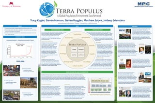
  • 1. Overview Data Access SystemData Integration Timeline TERRA POPULUS A Global Population/Environment Data Network Terra Populus (TerraPop) provides global-scale data on human population characteristics, land use, land cover, and climate change. The data are integrated across time and space, made available to researchers and the public, and preserved for future generations. The TerraPop data access system allows users to easily obtain customized datasets incorporating information from a variety of population and environmental data sources into an integrated package tailored to meet the users’ needs. Partners Tabulate population characteristics of administrative units from microdata Attach characteristics of administrative units to person or household records Distribute properties of polygons to grid cells Calculate totals, means, and other summaries of gridded variables within polygons Attach contextual data from rasters to person or household records Tabulate population characteristics of administrative units from microdata and distribute over a spatial grid Restricted access beta testing Summer – Fall 2013 Public beta Late 2013 TerraPop 1.0 Spring 2014 What is raster data? Available in TerraPop 1.0 Future additions Spatial grids in which each grid cell contains the value of a variable at that location. • Global land cover (GLC 2000) • Global temperature and precipitation (WorldClim) • Global harvested area and yield for 175 crops • Additional land cover and climate datasets • Elevation • Vegetation characteristics • Gridded Population of the World • Global Rural-Urban Mapping Project • Bioclimatic/ecological zones What is microdata? Available in TerraPop Future additions Census records for individuals and households 200+ censuses from 70+ countries, with more censuses added each year • Household relationships • Fertility and mortality • Migration • Education and work • Utilities and amenities • Economics • Dwelling characteristics What is area-level data? Available in TerraPop 1.0 Data about places defined by boundaries Population summaries • Basic demographics • Education • Employment • Household utilities & amenities Additional boundaries • More lower-level administrative units • Watersheds Administrative units • First-level (e.g. states) in most countries • Second-level (e.g. counties) in several countries • Current, historical, and harmonized • Economics • Health • Legal and policy • Agriculture Location-Based Integration TerraPop leverages geographic properties to integrate information from datasets in multiple data structures to generate customized, integrated datasets for users. Users can mix and match variables originating in raster, area-level, and/or microdata datasets, and obtain output in whichever of the three structures best meets their needs. The TerraPop system uses information about the location of each record in the original data to attach contextual information, generate spatial summaries, or assign values to points, depending on the transformation requested. Browse Variables and Metadata Select Variables and Datasets Choose Output Structure Define Output Options Get Data! Browse variables in a variety of topics and view basic availability information Easily access more detailed metadata about each variable Many variables, especially from census data, appear in multiple datasets, so you must specify the datasets from which you want data. Selections appear in your data cart Depending on the variables in your cart, you can choose area-level, microdata, or raster output Depending on the type of output you choose, you may need to select additional options, such as geographic level or operations to summarize raster data to administrative units. You will receive an e-mail when your customized dataset is ready to download.Funding provided by NSF Award OCI-0940818