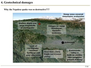
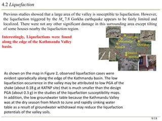
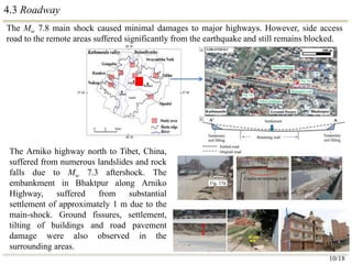
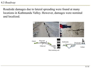
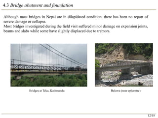
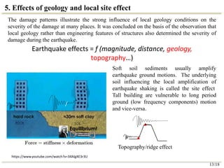
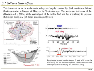
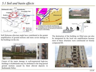
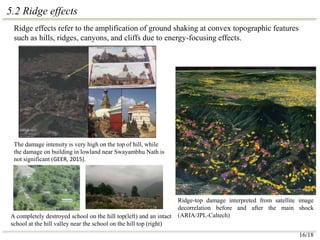
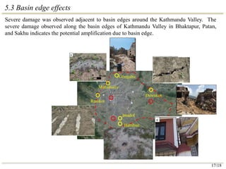
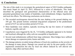
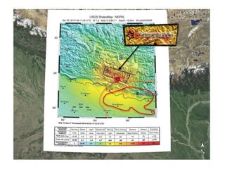
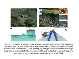
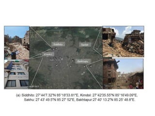
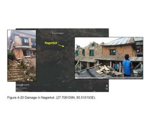
VIP Call Girls Service Kondapur Hyderabad Call +91-8250192130
Graduate Seminar_Keshab.pptx
1. GEOTECHNICAL ENGINEERING ASPECT OF THE 2015
GORKHA, NEPAL, EARTHQUAKE
Keshab Sharma
Graduate Student
Department of Civil and Environmental Engineering
University of Alberta
March 02, 2016
Department of Civil & Environmental Engineering
School of Mining & Petroleum Engineering
University of Alberta
2. Contents
1. Introduction
2. Plate tectonic and geology of Nepal
3. Ground motions and response spectra
4. Geotechnical damages
1. Landslides, Slope Failures and Fissures
2. Liquefaction
3. Roadway
4. Bridge abutment and foundation
5. Effects of geology and local site effects
1. Soil and basin effects
2. Ridge effects
3. Basin edge effects
6. Conclusions
1/18
3. 1. Introduction
A magnitude (Mw) 7.8 earthquake occurred 80 km
to the northwest of Kathmandu Valley (capital of
Nepal) on April 25, 2015.
Another earthquake (after shock) of Mw 7.3 shook
the region again on May 12, having the epicentral
location in Kodari region, north-east of
Kathmandu,
More than 400 aftershocks with a magnitude above
4 have been observed since the main-shock.
Caused 8,790 deaths and injured 22,300 people in
Nepal and 8 M people (one third of total
population) were affected.
Damaged at least 0.8 M houses partly or
completely.
About 4,000 landslides (small to mega) were
identified.
Estimated damage about $10 billion, nearly half of
GDP (Gross Domestic Product) of Nepal
Kathmandu Valley
2/18
4. 2. Plate tectonic and geology of Nepal
Indo-Australian plate
Eurasian plate
Nepal is prone to earthquakes because it is at the junction of the Indo-Australian and
Eurasian tectonic plates. The Himalayas were created when the plates collided
millions of years ago, and the still moving Indo-Australian plate pushes the
mountains a few millimeters higher every year.
3/18
6. 2. Plate tectonic and geology of Nepal
The Himalayan Range is a young mountain system of world. Lesser Himalaya, where the
main shock epicenter is located, contains primarily sedimentary and meta-sedimentary rocks ,
such as shale, limestone, and sandstone, aged from Cambrian to Eocene.
X
X
Source: Raonline
Cross-section at X-X
5/18
7. 3. Ground motion and response spectra
Peak ground acceleration (PGA) in horizontal direction
at this site is 164 gal (1 gal = 1 cm/sec2), which may be
considerably large to cause damages to buildings and soil
structures.
Acceleration records contain the long-period
components, which may be affected by the soft
sedimentary basin effects in Kathmandu Valley.
6/18
0.47 sec
5 sec
5 sec
8. 4. Geotechnical damages
Steep slope, young,
fragile and dynamic
geology
Why the Nepalese quake was so destructive???
7/18
9. 4.1 Landslides, Slope Failures and Fissures
Damage in Baluwa near main shock epicentre (A) Fallen boulder. (B)
Shallow landslide; debris blocked the road. (C) Large landslide (100 m high
and 300 m wide); debris blocked the road and disconnected villages further
north of Baluwa. (D) Devastated houses in Baluwa
Numerous earthquake – induced landslides were observed as we travelled toward epicentre
through the mountainous terrain from Kathmandu.
Most landslides were shallow, typically involving the top few meters of weathered bedrock,
regolith, and soil. Many of the landslides were still active during the field trip.
E
Melamchi
Bidur
Gorkha
Besi-Sahar
Baluwa
Mw 7.8
Bharatpur
Kathmandu Valley Dhulikhel
Dolalghat
0 25 50 km
C&D
B
A
E
N
Rock fall along Mugling –NGT Highway Ground fissures
8/18
10. 4.2 Liquefaction
Previous studies showed that a large area of the valley is susceptible to liquefaction. However,
the liquefaction triggered by the Mw 7.8 Gorkha earthquake appears to be fairly limited and
localized. There were not any other significant damage in this surrounding area except tilting
of some houses nearby the liquefaction region.
Interestingly, Liquefactions were found
along the edge of the Kathmandu Valley
basin.
Imadol
Hattiban
Gongabu
Manamaiju
Ramkot
Duwakot
9/18
As shown on the map in Figure 2, observed liquefaction cases were
evident sporadically along the edge of the Kathmandu basin. The low
liquefaction occurrence in the valley may be attributed to low PGA of the
shake (about 0.18 g at KATNP site) that is much smaller than the design
PGA (about 0.3 g) in the studies of the liquefaction susceptibility maps.
In addition, the low groundwater table because the Kathmandu Valley
was at the dry season from March to June and rapidly sinking water
table as a result of groundwater withdrawal may reduce the liquefaction
potentials of the valley soils.
11. 4.3 Roadway
The Mw 7.8 main shock caused minimal damages to major highways. However, side access
road to the remote areas suffered significantly from the earthquake and still remains blocked.
10/18
The Arniko highway north to Tibet, China,
suffered from numerous landslides and rock
falls due to Mw 7.3 aftershock. The
embankment in Bhaktpur along Arniko
Highway, suffered from substantial
settlement of approximately 1 m due to the
main-shock. Ground fissures, settlement,
tilting of buildings and road pavement
damage were also observed in the
surrounding areas.
12. 4.3 Roadway
Roadside damages due to lateral spreading were found at many
locations in Kathmandu Valley. However, damages were nominal
and localized.
11/18
13. 4.3 Bridge abutment and foundation
Although most bridges in Nepal are in dilapidated condition, there has been no report of
severe damage or collapse.
Most bridges investigated during the field visit suffered minor damage on expansion joints,
beams and slabs while some have slightly displaced due to tremors.
Baluwa (near epicentre)
Bridges at Teku, Kathmandu
12/18
14. 5. Effects of geology and local site effect
13/18
The damage patterns illustrate the strong influence of local geology conditions on the
severity of the damage at many places. It was concluded on the basis of the observation that
local geology rather than engineering features of structures also determined the severity of
damage during the earthquake.
Earthquake effects = f (magnitude, distance, geology,
topography…)
/
https://www.youtube.com/watch?v=34AlgXE3r3U
Soft soil sediments usually amplify
earthquake ground motions. The underlying
soil influencing the local amplification of
earthquake shaking is called the site effect
Tall building are vulnerable to long period
ground (low frequency components) motion
and vice-versa.
/
Topography/ridge effect
15. 5.1 Soil and basin effects
Long-period ground motion (about 5 sec), which may be
affected by the soft sedimentary basin effects on the duration
and amplification of shaking in Kathmandu Valley
The basement rocks in Kathmandu Valley are largely covered by thick semi-consolidated
fluvio-lacustrine sediments of Pliocene to Pleistocene age. The maximum thickness of the
alluvium soil is 550 m at the central part of the valley. Soft soil has a tendency to increase
shaking as much as 2 to 6 times as compared to rock.
14/18
16. 5.1 Soil and basin effects
Soft Holocene alluvium might have contributed to the greater
amplification of ground motions and more severe damage to
the buildings on the site.
The destruction of the building on filled area can also
be interpreted by the local site amplification because
most of these structures were constructed on loosely
compacted fill.
Causes of the major damage in well-engineered high-rise
buildings in Kathmandu may be attributed to the long-period
ground motions caused by thick alluvial deposits in
Kathmandu Valley.
15/18
17. 5.2 Ridge effects
Ridge-top damage interpreted from satellite image
decorrelation before and after the main shock
(ARIA/JPL-Caltech)
A completely destroyed school on the hill top(left) and an intact
school at the hill valley near the school on the hill top (right)
The damage intensity is very high on the top of hill, while
the damage on building in lowland near Swayambhu Nath is
not significant (GEER, 2015).
Ridge effects refer to the amplification of ground shaking at convex topographic features
such as hills, ridges, canyons, and cliffs due to energy-focusing effects.
16/18
18. 5.3 Basin edge effects
Severe damage was observed adjacent to basin edges around the Kathmandu Valley. The
severe damage observed along the basin edges of Kathmandu Valley in Bhaktapur, Patan,
and Sakhu indicates the potential amplification due to basin edge.
Imadol
Hattiban
Gongabu
Manamaiju
Ramkot
Duwakot
17/18
19. 6. Conclusions
The aim of this study is to investigate the geotechnical aspect of 2015 Gorkha earthquake
that struck Nepal on April 25, 2015, followed by a series of aftershocks. This study
described the geological and geotechnical characteristics of the affected areas and
presented geotechnical case studies of landslides, road embankment, bridges, liquefaction
and local site effects. The following conclusions can be drawn.
The recorded accelerograms showed that the max shaking at the ground shaking was
184 gal. The ground motions contained long-period component at the predominant
period of 0.47 sec and secondary period of 5.0 sec.
Most landslides were shallow, typically involving the top few meters of weathered
bedrock, regolith, and soil.
Liquefaction cases triggered by the Mw 7.8 Gorkha earthquake appeared to be limited
and localized, although the valley soils are susceptible to liquefaction.
Several road embankments suffered from large settlement. Most bridges have suffered
minor damage on expansion joints, beams and slabs.
The damage patterns revealed strong influence of local site conditions on the severity of
the damage at many places. Damage was caused not only by the poor quality of non-
engineered construction but also by local site effects induced by soft alluvial soil
deposits, ridge effect and basin effect.
18/18
20. Acknowledgement
The post-earthquake reconnaissance was funded by the Japan Society for the Promotion of
Science (JSPS). The author appreciate the discussions with Prof. T. Kiyota of the University
of Tokyo, Japan and Dr. K. Goda of the University of Bristol, England.
22. 5. Effects of geology and local site effect
Soft soils-tendency to increase shaking as
much as 2 to 6 time as compared to rock.
Over bed rock Over lake clay
EW component
NS component
UD component
Soil and basin effects Ridge effects Basin edge effect
The damage patterns illustrate the strong influence of local geology conditions on the severity of the
damage at many places. It was concluded on the basis of the observation that local geology rather than
engineering features of structures also determined the severity of damage during the earthquake.
Ratio of response spectrum at
top to toe of hill.
Editor's Notes
Nepal is located in the centre of the Himalayan concave chain. The Himalayan arc, which marks an active boundary between Indian and Eurasian plates, has caused numerous major earthquakes of moment magnitude 7.5 or greater in past centuries. The 2015 Gorkha earthquake were the result of thrust faulting between the subducting India plate and the Eurasia plate to the north (Fig. 1b), where the Indian plate converges with the Eurasian plate at a rate of approximately 45 mm/year towards the north-northeast, driving the uplift of the Himalayas and the Tibetan Plateau [14]
55 to 40 million-Eocene 570-500 million Cambrian
As shown on the map in Figure 2, observed liquefaction cases were evident sporadically along the edge of the Kathmandu basin. The low liquefaction occurrence in the valley may be attributed to low PGA of the shake (about 0.18 g at KATNP site) that is much smaller than the design PGA (about 0.3 g) in the studies of the liquefaction susceptibility maps. In addition, the low groundwater table because the Kathmandu Valley was at the dry season from March to June and rapidly sinking water table as a result of groundwater withdrawal may reduce the liquefaction potentials of the valley soils.
The ground fissures extend hundreds of meters diagonally across the highway (Figs. 12a and 13d), damaging and tilting a number of buildings and boundary walls. This in fact indicates that the whole ground along with the buildings on this side has subsided by more than one meter. At some places the ground cracks measured 40 cm wide (Fig. 13d). Fig. 13 shows that apart from the subsidence, the embankment did not suffer from major structural damage. Only minor damage such as cracks and fissures, slight tilting, and differential settlement (Fig. 13c) was observed in reinforced soil retaining wall. However, as shown in Fig. 13d, larger fissures and settlements were found in the surrounding area. Overall, the reinforced retaining walls and earth embankment demonstrated good performance against the earthquake.
Deep sedimentary basins can significantly amplify and lengthen the period of bedrock ground motions, such effect of deep sedimentary basin on the surface ground motion is known as basin effects.
There were about 11 high-rise apartments (≥ 15 stories) that suffered severe damage to the infill walls and were declared unsafe for habitation. The scatter of failed multi-storey buildings throughout the cities of Kathmandu, Bhaktpur, and Lalitpur implies that the damage may not be purely attributed to the poor quality construction materials, or the inadequate design since there was relatively lesser damage in similar types of buildings having fewer stories. It is inferred that soil amplification of long-period ground motion due to the soft deep valley sediment might have caused greater damage to high-rise buildings as compared to short ones, probably due to double resonance effects. High-rise buildings with longer predominant periods are expected to be vulnerable to such long-period ground motions, while shorter buildings with lower predominant periods are expected to have less damage.
Large numbers of school buildings were reported collapsed or severely damaged. In Nepal, school building is often constructed on hilltops. So, collapse of the school buildings on the hill may be attributed to the ground motion amplification by the hill