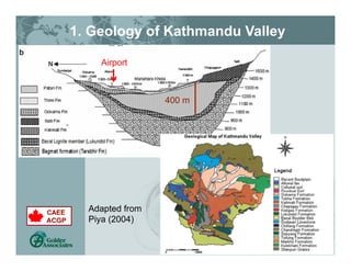
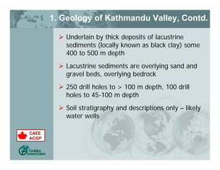
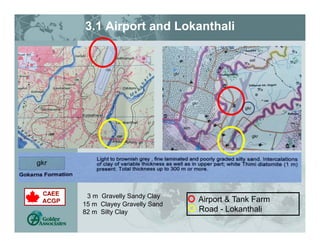
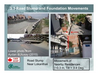
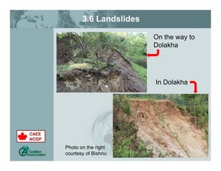
The document summarizes observations from a post-earthquake site reconnaissance in Nepal following the 2015 Gorkha earthquake. It describes the geology of the Kathmandu Valley area, including thick deposits of lacustrine sediments up to 500 meters deep. It then discusses locations where geotechnical damage was observed, including minor cracking at the airport runway, movement of a road and nearby structures in Lokanthali, and landslides in Dolakha. The summary concludes that for an earthquake of this magnitude, the observed geotechnical damage was relatively limited and localized, likely due to the peak ground shaking being lower than design levels and the short duration of strong shaking.
![2. EQ Epicenters and Shaking Intensity
[ref. Aydan & Ulusay, Goda et al, 2015]
• Shallow Earthquakes (<15 km)
• Epicenters of aftershocks West -> East
• Mw 7.9 Main Shock 77 km NW of Kathmandu,
7.3 Aftershock east of Kathmandu
Kathmandu
80 km](https://image.slidesharecdn.com/4fb09276-14b2-4932-a641-cfcf2e8bf280-160711000111/85/11CCEE_Nepal_Presentation_July23_Geotechnical_Final-5-320.jpg)
![2. EQ Epicenters and Shaking Intensity,
Contd. [KATNP Stn]
After Goda et al (2015)
• PGA ~0.15 g
• 2 – 3 cycles of
strong shaking
lasting for ~10s
• Long period
cycles](https://image.slidesharecdn.com/4fb09276-14b2-4932-a641-cfcf2e8bf280-160711000111/85/11CCEE_Nepal_Presentation_July23_Geotechnical_Final-6-320.jpg)
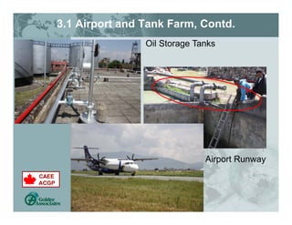
![3.1 Airport and Tank Farm, Contd.
There is some cracking on the runway;
There is a substantial layer of rubber on the
runway, due to the intense use for the
emergency relief operations;
The Taxiway is overstressed due to the
emergency relief operations, compounded by:
Heavy loads
Repetitions
TIA has identified the need for a hardened
Emergency Response Center and a new Air
Traffic Control Tower.
[Slide by Pablo Riofrio Ando]](https://image.slidesharecdn.com/4fb09276-14b2-4932-a641-cfcf2e8bf280-160711000111/85/11CCEE_Nepal_Presentation_July23_Geotechnical_Final-9-320.jpg)
![3.2 Sewerage Treatment Plant
Bagmati Area Sewerage
Treatment Plant
[Near the Airport]
Oxidation Secondary
Treatment Tanks
Secondary
Clarifiers](https://image.slidesharecdn.com/4fb09276-14b2-4932-a641-cfcf2e8bf280-160711000111/85/11CCEE_Nepal_Presentation_July23_Geotechnical_Final-10-320.jpg)
![4. Summary
1. CAEE Team visited several areas in Kathmandu
and Dolakha from June 10-16, 2015.
2. Geotechnical damage observed was
limited/minimal and localized for an earthquake of
this magnitude and soils in Kathmandu.
3. Design ground shaking for Kathmandu = 0.42 g,
but peak shaking felt ~ 0.15 g ~ 1/3rd of design
PGA
4. Duration of strong shaking ~ 10 seconds with 2-3
cycles of strong shaking [low for M7.9].
5. Earthquake occurred during the dry months of the
year; ground water table may have been deep
6. 3., 4. and 5. above are possible reasons why the
observed geotechnical damage was low/localized.](https://image.slidesharecdn.com/4fb09276-14b2-4932-a641-cfcf2e8bf280-160711000111/85/11CCEE_Nepal_Presentation_July23_Geotechnical_Final-15-320.jpg)