gis_disciplines.pdf
•
0 likes•8 views
The document discusses how GIS is used across multiple disciplines including archaeology, economics, biology/ecology, political science, public administration, nursing/health, geology, history, environmental studies, engineering, and geography. GIS provides spatial analysis and mapping capabilities that help researchers, policymakers, and organizations understand patterns and make informed decisions in their respective fields.
Report
Share
Report
Share
Download to read offline

Recommended
Application of gis in urban planning
GIS technology is useful for urban planning by helping to analyze urban growth and identify suitable sites for development based on factors like accessibility, topography, land use, and water resources. GIS can be used to create resource inventories by integrating remote sensing data, analyze existing urban situations through overlay analysis, model and project future population changes, develop planning options through land suitability maps and spatial optimization, help select options through multi-criteria analysis, and aid in plan implementation through environmental impact assessments. In summary, GIS is crucial for sustainable urban development and economic growth by allowing rapid updating of data layers and assessment of land use changes over time to inform better urban planning.
Gis applications
This document provides summaries of various applications of GIS technology across different domains:
1) GIS is used for urban planning to analyze urban growth and expansion and identify suitable sites for development based on factors like accessibility, land flatness, current usage and water supply.
2) GIS provides mapping functionality and allows non-cartographers to visually represent data on maps. Examples include Google Maps, Bing Maps and Yahoo Maps.
3) GIS helps monitor coal mine safety and identify risks of spontaneous combustion fires.
4) GIS supports business applications like customer tracking, site selection, marketing and optimizing sales territories.
5) GIS is useful for public health applications like evaluating health policies, studying relationships between
Gis applications in tourism a tool for sustainable tourism
GIS can be an effective tool for sustainable tourism development by helping decision makers evaluate environmental impacts, identify potential conflicts, and model relationships between tourism and other sectors. GIS allows tourism data to be integrated and analyzed spatially, helping with resource mapping, impact assessment, and tourism planning. Some benefits of GIS for tourism include cost savings through efficiency, improved decision making considering location factors, better communication of geographic information, and managing tourism development geographically. While challenges remain, GIS has been successfully used in tourism applications like mapping attractions and building interactive online maps.
What is-gis
This document provides an overview of geographic information systems (GIS) and how GIS is used across many industries and fields. It begins with an introduction to GIS and how GIS links geographic data to other information. The document then describes how GIS is used in business, defense, government, natural resources, transportation, utilities and more. It provides examples of how GIS helps with tasks like facilities management, marketing, emergency response and more. The document aims to demonstrate how location matters to decision making and that GIS is a tool that can help organizations in many sectors.
Geographical Information System and Karnataka Forest cover digitization
This work is an effort to share GIS awareness, Digitization and map making of the forest cover of Karnataka between 2001 and 2011.
GIS
Introduction
Component
Application
About the state: Karnataka
Introduction
History
Geography
Economy
Administrative Division
Demography
Education
Transport
Tourism
Geo-referencing and Digitization
Data Joining & Map Making
Software used: QGIS 2.0.1
Geographic Information System.pdf
This report summarizes a survey of the Taluka Sports Complex in Paithan using Google Earth and GPS. The sports complex was established in 2007 and contains facilities for tennis, football, gymnastics, boxing, squash, and cricket. The total land area is 1.48 acres. GPS was used to obtain latitude and longitude coordinates at 4 points around the complex. When compared to the Google Earth coordinates, small differences of up to 3 meters were found at some points, likely due to GPS or Google Earth inaccuracies. The report concludes that there can be slight differences between coordinates from online maps versus physical measurements.
A New Dimension
The document discusses how Honolulu, Hawaii is using 3D modeling and GIS to plan for an elevated rail system and transit-oriented development (TOD). Three core models were created - walkability, urban growth, and densification. Esri CityEngine was used to develop 3D geometry and textures of the proposed rail corridor and TOD. Holograms were also created from the 3D models to provide unique views for stakeholders and the public to communicate how the changes could positively impact the community by controlling urban sprawl and reducing traffic. The goal was to build support for the rail project and TOD approach through collaborative planning and visualization tools.
GIS Application Used in Urban Planning In India
This document discusses how geographic information systems (GIS) are used for urban planning in India. It provides an overview of GIS, describing it as a system for capturing, storing, analyzing, and managing spatially referenced data. GIS allows users to create maps, perform spatial queries and analysis, and visualize and model information. The document outlines how GIS is used in various aspects of urban planning like infrastructure development, transportation planning, and monitoring of health, sanitation, and other city services. It provides examples of how GIS aids in tasks like feasibility studies, land use planning, and public participation in the planning process. Overall, the document illustrates how Indian planners leverage GIS technologies to effectively plan and manage urban development.
Gis
This document provides an overview of geographic information systems (GIS) and their applications in civil engineering, the environment, and natural resource management. It discusses how GIS integrates data from various sources and disciplines to store, manipulate, analyze, and display spatial information. GIS has become an important tool for tasks like infrastructure and urban planning, natural resource management, and disaster mitigation by allowing users to query data, find optimal routes, and better understand spatial relationships. The document also covers GIS components like maps, coordinate systems, software, and how various fields contributed to the development of GIS technology.
3D GIS for urban development
3D GIS brings enhanced depth into data collection and analysis by incorporating a z-value into mapping. Most commonly, that means including elevation data, but users have many options for adding layers of information.
While 3D models are more difficult to create and maintain than 2D ones, there are myriad 3D GIS applications where this technology is greatly beneficial.
The 3D-GIS in the Cloud main purpose is to evaluate the use-efficiency of both existing and planned spatial space.
Gis applications & Implement
this slide will help you to learn about gis applications in human life, its usefulness and necessity is broad.
application of gis rs in urban planninggem-150307035531-conversion-gate01 (1)...
This document discusses the application of remote sensing and GIS in urban planning. It begins by defining remote sensing and GIS. It then outlines several uses of remote sensing in urban planning, such as land use/cover mapping, environmental monitoring, and updating basemaps. The document also discusses how GIS can be used as a tool in urban planning for tasks like overlay analysis, buffering, accessibility analysis, and optimal routing. Finally, it concludes that remote sensing and GIS provide useful analysis and visualization tools to help address challenges faced by urban managers and policy makers.
Remote sensing GIS and public policy
This document discusses the use of geographic information systems (GIS) for various purposes. It begins by outlining six principles for GIS use, including thinking spatially, using data appropriately, and believing in data sharing. It then covers what GIS is, its components and applications for fields like environmental impact assessment, social sciences, natural resource management, disaster risk reduction, participatory planning, and decision support/public policy. Specific examples discussed include using GIS for flood mapping, natural resource management, understanding disease spread, and evaluating government programs for tribal communities. The document emphasizes how GIS can help improve decision-making by integrating spatial data from various sources.
Urban planing & gis
GIS can be applied to various urban planning problems, such as master planning, area monitoring, regional potential analyses, site selection studies, and the documentation and approval of development plans. It is useful for interpreting and formulating land use policy, modeling likely land use changes, and assessing the impacts of predicted land use changes. GIS is also significant for environmental planning, such as developing natural resource inventories, identifying pollution sources, assessing constraints, and determining suitability for waste treatment techniques. It can also help with wetland applications like regional inventories.
Topic Introduction to GIS and its Applications.pptx
The document provides an introduction to geographic information systems (GIS) including:
- A definition of GIS as an integrated system that combines geographic and tabular data using software for analysis and presentation of that analysis in map form.
- A brief history of early GIS maps including John Snow's 1855 cholera map, one of the first epidemiological maps.
- An overview of current applications of GIS including 3D modeling, web-based GIS, and a wide range of uses in fields such as urban planning, environmental science, business, health care, and more.
- A quote from GIS pioneer Jack Dangermond that the applications of GIS are limited only by users' imaginations
Role of gis in climate change
This document provides an introduction to geographic information systems (GIS). It defines GIS as a system that integrates hardware, software, and data to capture, manage, analyze and display geographical information. The key components of GIS are described, including spatial data formats like raster and vector data. Examples of how GIS is used are given, such as by utility companies, for transportation, agriculture, and climate change analysis. The document also discusses how GIS can help address climate change through applications like monitoring deforestation, climate modeling, and determining best locations for alternative energy. It concludes by noting several organizations in Pakistan that are currently using GIS.
Gis dr rahul
This document provides an overview of geographic information systems (GIS) and their applications in public health. It discusses the history and development of GIS from the earliest uses in epidemiology in the 1800s to modern digital systems. Key aspects of GIS covered include data representation methods, uncertainties, terminology, and limitations. The document also outlines several important uses of GIS in public health such as mapping disease distribution and identifying at-risk populations.
The Mapping Revolution: Incorporating Geographic Information Systems in Gover...
Since the beginning of civilization, humans have used images as a means to tell stories. We have used images to educate, entertain or to build a just and moral society. Our ancient ancestors would use images to remember stories and archive information for future generations. Similar to our ancient ancestors, we use images today to convey meaning, understand complex relationships and improve communication.
The use of mapping and geospatial technology is at the heart of story telling and improved communications. As the challenges of the public sector continue to grow in complexity, efficient and effective communication tools are essential. Today, government is more interconnected than ever before, and the complexity has led to increased integration between state, local and federal officials. At all levels of government, agencies are looking for solutions to find value and improve public sector decision-making through data. http://www.govloop.com/profiles/blogs/govloop-guide-the-mapping-revolution-incorporating-geographic-inf
FULLYFINAL GIS CHOUBEYJI.pptx
This document provides information about a student named Harshit Choubey who completed a GIS science practical report under the guidance of Dr. Rajendra Singh. It includes Harshit's personal details like name, roll number, college, and year of study. It also contains a certificate confirming completion of the report and an acknowledgement section thanking various people who provided support and guidance. Finally, it outlines the contents of the GIS science practical report.
Not the Geography You Remember
If you took a Geography course over 20 years ago, you might recall the subject involving little more than memorizing the locations of continents, countries, cities, as well as climate and cultural facts. In that time, many universities have expanded their geography programs by entering the world of Geographic Information Systems, or GIS for short. In the beginning GIS was an obscure field of specialized hardware, software, and cryptic keyboard commands that allowed a skilled professional to query data to get answers to geographic-based inquiries. Queries, such as the quantity of forested acres within an area, were the beginning of the geographicbased analysis revolution that has since unfolded. But today’s leading geography programs are teaching students more than just the where, what, who, and why of our world, but also bring to the table an interdisciplinary approach to solving today’s local, regional, national, and global problems. Many of these programs are not limited to just universities, now involving the K-12 space, tapping into young people’s minds to unleash innovative ideas in what is now an interdisciplinary field. To maintain a competitive advantage in today’s world, leading countries, companies, and research organizations are embracing these new capabilities and the talent that is available in the marketplace.
Sonti's Article
This document discusses the application of Geographic Information Systems (GIS) in forest management. It explains that GIS, along with technologies like GPS and remote sensing, allow forest managers to more accurately collect, analyze, and utilize spatial data. This helps with tasks like resource management, harvest planning, fire management, and map production. The document then provides examples of how GIS has been used specifically in strategic planning, modeling, and fire management. Overall, it argues that GIS is a valuable tool for aiding complex modern forest management.
Application of gis & rs in urban planning
Remote sensing uses sensors aboard satellites or aircraft to acquire spatial, spectral and temporal data about objects without physical contact. This data is digitized and processed into images. GIS is a system that integrates hardware, software and data to capture, store, analyze and display spatial or geographic information. Remote sensing and GIS are useful tools for urban planning applications such as land use/cover mapping, environmental monitoring, updating basemaps, studying urban growth, transportation systems, and site suitability analysis. GIS allows for overlaying of maps, buffering, and route analysis to support zoning, land management, emergency response and other planning needs. Together, remote sensing and GIS provide timely, reliable spatial data and analysis functions for addressing challenges
Application Of GIS In Environmental Engineering
This document discusses the application of geographic information systems (GIS) in environmental engineering. It begins by providing background on GIS, explaining that GIS allows spatial data to be collected, analyzed, and used to make decisions about the environment. It then gives examples of how GIS can be used for environmental engineering tasks like mapping water pollution, assessing drought impacts, and monitoring floods. The document also outlines the basic process for a GIS analysis and discusses some key features of GIS that are useful for environmental engineers, such as mapping patterns and modeling "what if" scenarios. It concludes by providing examples of how GIS has been applied to tasks like environmental impact assessments and planning for/managing environmental hazards and risks.
GIS KD.pdf
This document contains a student's certificate for completing a GIS practical report under the guidance of Dr. Bharat Ratnu at Shivaji College, University of Delhi. The certificate includes the student's name, roll number, program of study, university roll number, and year. It is certified that the student successfully completed the GIS science practical report. The document also includes an acknowledgement section thanking various individuals and institutions for their support and guidance during the project. Finally, it outlines the contents of the GIS practical report, listing 5 plates covering different GIS data structures and a section on land use and land cover analysis.
ASSESSMENT OF URBAN DYNAMICS IN LAND USE AND DEMOGRPAHY USING GIS TECHNIQUES
This document summarizes a study that assesses urban dynamics related to land use and demography using GIS techniques. The study examines literature and case studies from national and international contexts to identify models, methods, and approaches for analyzing urban growth and land use patterns. Key indicators related to land use changes and population density are identified. The study also explores the use of tools like GIS, remote sensing, GPS, and modeling to analyze land use patterns and forecast future scenarios to inform urban planning and management strategies. The conclusion highlights the importance of adapting sustainable urbanization strategies that consider the spatial and temporal scale of change.
INTRODUCTION TO GIS AND GEOREFRENCING.pptx
Georeferencing is the name given to the process of transforming a scanned map or aerial photograph so it appears “in place” in GIS. By associating features on the scanned image with real world x and y coordinates, the software can progressively warp the image so it fits to other spatial datasets.
GIS in Civil Engineering
This document discusses the use of geographic information systems (GIS) in civil engineering. It provides an overview of GIS, including its history and components. It then discusses several applications of GIS in civil engineering, such as for transportation engineering, watershed analysis, remote sensing, waste management, regional planning, and landslide analysis. GIS allows civil engineers to integrate spatial and non-spatial data from various sources to facilitate complex analysis and decision-making regarding infrastructure development and management.
Use PyCharm for remote debugging of WSL on a Windo cf5c162d672e4e58b4dde5d797...
This document serves as a comprehensive step-by-step guide on how to effectively use PyCharm for remote debugging of the Windows Subsystem for Linux (WSL) on a local Windows machine. It meticulously outlines several critical steps in the process, starting with the crucial task of enabling permissions, followed by the installation and configuration of WSL.
The guide then proceeds to explain how to set up the SSH service within the WSL environment, an integral part of the process. Alongside this, it also provides detailed instructions on how to modify the inbound rules of the Windows firewall to facilitate the process, ensuring that there are no connectivity issues that could potentially hinder the debugging process.
The document further emphasizes on the importance of checking the connection between the Windows and WSL environments, providing instructions on how to ensure that the connection is optimal and ready for remote debugging.
It also offers an in-depth guide on how to configure the WSL interpreter and files within the PyCharm environment. This is essential for ensuring that the debugging process is set up correctly and that the program can be run effectively within the WSL terminal.
Additionally, the document provides guidance on how to set up breakpoints for debugging, a fundamental aspect of the debugging process which allows the developer to stop the execution of their code at certain points and inspect their program at those stages.
Finally, the document concludes by providing a link to a reference blog. This blog offers additional information and guidance on configuring the remote Python interpreter in PyCharm, providing the reader with a well-rounded understanding of the process.
More Related Content
Similar to gis_disciplines.pdf
Gis
This document provides an overview of geographic information systems (GIS) and their applications in civil engineering, the environment, and natural resource management. It discusses how GIS integrates data from various sources and disciplines to store, manipulate, analyze, and display spatial information. GIS has become an important tool for tasks like infrastructure and urban planning, natural resource management, and disaster mitigation by allowing users to query data, find optimal routes, and better understand spatial relationships. The document also covers GIS components like maps, coordinate systems, software, and how various fields contributed to the development of GIS technology.
3D GIS for urban development
3D GIS brings enhanced depth into data collection and analysis by incorporating a z-value into mapping. Most commonly, that means including elevation data, but users have many options for adding layers of information.
While 3D models are more difficult to create and maintain than 2D ones, there are myriad 3D GIS applications where this technology is greatly beneficial.
The 3D-GIS in the Cloud main purpose is to evaluate the use-efficiency of both existing and planned spatial space.
Gis applications & Implement
this slide will help you to learn about gis applications in human life, its usefulness and necessity is broad.
application of gis rs in urban planninggem-150307035531-conversion-gate01 (1)...
This document discusses the application of remote sensing and GIS in urban planning. It begins by defining remote sensing and GIS. It then outlines several uses of remote sensing in urban planning, such as land use/cover mapping, environmental monitoring, and updating basemaps. The document also discusses how GIS can be used as a tool in urban planning for tasks like overlay analysis, buffering, accessibility analysis, and optimal routing. Finally, it concludes that remote sensing and GIS provide useful analysis and visualization tools to help address challenges faced by urban managers and policy makers.
Remote sensing GIS and public policy
This document discusses the use of geographic information systems (GIS) for various purposes. It begins by outlining six principles for GIS use, including thinking spatially, using data appropriately, and believing in data sharing. It then covers what GIS is, its components and applications for fields like environmental impact assessment, social sciences, natural resource management, disaster risk reduction, participatory planning, and decision support/public policy. Specific examples discussed include using GIS for flood mapping, natural resource management, understanding disease spread, and evaluating government programs for tribal communities. The document emphasizes how GIS can help improve decision-making by integrating spatial data from various sources.
Urban planing & gis
GIS can be applied to various urban planning problems, such as master planning, area monitoring, regional potential analyses, site selection studies, and the documentation and approval of development plans. It is useful for interpreting and formulating land use policy, modeling likely land use changes, and assessing the impacts of predicted land use changes. GIS is also significant for environmental planning, such as developing natural resource inventories, identifying pollution sources, assessing constraints, and determining suitability for waste treatment techniques. It can also help with wetland applications like regional inventories.
Topic Introduction to GIS and its Applications.pptx
The document provides an introduction to geographic information systems (GIS) including:
- A definition of GIS as an integrated system that combines geographic and tabular data using software for analysis and presentation of that analysis in map form.
- A brief history of early GIS maps including John Snow's 1855 cholera map, one of the first epidemiological maps.
- An overview of current applications of GIS including 3D modeling, web-based GIS, and a wide range of uses in fields such as urban planning, environmental science, business, health care, and more.
- A quote from GIS pioneer Jack Dangermond that the applications of GIS are limited only by users' imaginations
Role of gis in climate change
This document provides an introduction to geographic information systems (GIS). It defines GIS as a system that integrates hardware, software, and data to capture, manage, analyze and display geographical information. The key components of GIS are described, including spatial data formats like raster and vector data. Examples of how GIS is used are given, such as by utility companies, for transportation, agriculture, and climate change analysis. The document also discusses how GIS can help address climate change through applications like monitoring deforestation, climate modeling, and determining best locations for alternative energy. It concludes by noting several organizations in Pakistan that are currently using GIS.
Gis dr rahul
This document provides an overview of geographic information systems (GIS) and their applications in public health. It discusses the history and development of GIS from the earliest uses in epidemiology in the 1800s to modern digital systems. Key aspects of GIS covered include data representation methods, uncertainties, terminology, and limitations. The document also outlines several important uses of GIS in public health such as mapping disease distribution and identifying at-risk populations.
The Mapping Revolution: Incorporating Geographic Information Systems in Gover...
Since the beginning of civilization, humans have used images as a means to tell stories. We have used images to educate, entertain or to build a just and moral society. Our ancient ancestors would use images to remember stories and archive information for future generations. Similar to our ancient ancestors, we use images today to convey meaning, understand complex relationships and improve communication.
The use of mapping and geospatial technology is at the heart of story telling and improved communications. As the challenges of the public sector continue to grow in complexity, efficient and effective communication tools are essential. Today, government is more interconnected than ever before, and the complexity has led to increased integration between state, local and federal officials. At all levels of government, agencies are looking for solutions to find value and improve public sector decision-making through data. http://www.govloop.com/profiles/blogs/govloop-guide-the-mapping-revolution-incorporating-geographic-inf
FULLYFINAL GIS CHOUBEYJI.pptx
This document provides information about a student named Harshit Choubey who completed a GIS science practical report under the guidance of Dr. Rajendra Singh. It includes Harshit's personal details like name, roll number, college, and year of study. It also contains a certificate confirming completion of the report and an acknowledgement section thanking various people who provided support and guidance. Finally, it outlines the contents of the GIS science practical report.
Not the Geography You Remember
If you took a Geography course over 20 years ago, you might recall the subject involving little more than memorizing the locations of continents, countries, cities, as well as climate and cultural facts. In that time, many universities have expanded their geography programs by entering the world of Geographic Information Systems, or GIS for short. In the beginning GIS was an obscure field of specialized hardware, software, and cryptic keyboard commands that allowed a skilled professional to query data to get answers to geographic-based inquiries. Queries, such as the quantity of forested acres within an area, were the beginning of the geographicbased analysis revolution that has since unfolded. But today’s leading geography programs are teaching students more than just the where, what, who, and why of our world, but also bring to the table an interdisciplinary approach to solving today’s local, regional, national, and global problems. Many of these programs are not limited to just universities, now involving the K-12 space, tapping into young people’s minds to unleash innovative ideas in what is now an interdisciplinary field. To maintain a competitive advantage in today’s world, leading countries, companies, and research organizations are embracing these new capabilities and the talent that is available in the marketplace.
Sonti's Article
This document discusses the application of Geographic Information Systems (GIS) in forest management. It explains that GIS, along with technologies like GPS and remote sensing, allow forest managers to more accurately collect, analyze, and utilize spatial data. This helps with tasks like resource management, harvest planning, fire management, and map production. The document then provides examples of how GIS has been used specifically in strategic planning, modeling, and fire management. Overall, it argues that GIS is a valuable tool for aiding complex modern forest management.
Application of gis & rs in urban planning
Remote sensing uses sensors aboard satellites or aircraft to acquire spatial, spectral and temporal data about objects without physical contact. This data is digitized and processed into images. GIS is a system that integrates hardware, software and data to capture, store, analyze and display spatial or geographic information. Remote sensing and GIS are useful tools for urban planning applications such as land use/cover mapping, environmental monitoring, updating basemaps, studying urban growth, transportation systems, and site suitability analysis. GIS allows for overlaying of maps, buffering, and route analysis to support zoning, land management, emergency response and other planning needs. Together, remote sensing and GIS provide timely, reliable spatial data and analysis functions for addressing challenges
Application Of GIS In Environmental Engineering
This document discusses the application of geographic information systems (GIS) in environmental engineering. It begins by providing background on GIS, explaining that GIS allows spatial data to be collected, analyzed, and used to make decisions about the environment. It then gives examples of how GIS can be used for environmental engineering tasks like mapping water pollution, assessing drought impacts, and monitoring floods. The document also outlines the basic process for a GIS analysis and discusses some key features of GIS that are useful for environmental engineers, such as mapping patterns and modeling "what if" scenarios. It concludes by providing examples of how GIS has been applied to tasks like environmental impact assessments and planning for/managing environmental hazards and risks.
GIS KD.pdf
This document contains a student's certificate for completing a GIS practical report under the guidance of Dr. Bharat Ratnu at Shivaji College, University of Delhi. The certificate includes the student's name, roll number, program of study, university roll number, and year. It is certified that the student successfully completed the GIS science practical report. The document also includes an acknowledgement section thanking various individuals and institutions for their support and guidance during the project. Finally, it outlines the contents of the GIS practical report, listing 5 plates covering different GIS data structures and a section on land use and land cover analysis.
ASSESSMENT OF URBAN DYNAMICS IN LAND USE AND DEMOGRPAHY USING GIS TECHNIQUES
This document summarizes a study that assesses urban dynamics related to land use and demography using GIS techniques. The study examines literature and case studies from national and international contexts to identify models, methods, and approaches for analyzing urban growth and land use patterns. Key indicators related to land use changes and population density are identified. The study also explores the use of tools like GIS, remote sensing, GPS, and modeling to analyze land use patterns and forecast future scenarios to inform urban planning and management strategies. The conclusion highlights the importance of adapting sustainable urbanization strategies that consider the spatial and temporal scale of change.
INTRODUCTION TO GIS AND GEOREFRENCING.pptx
Georeferencing is the name given to the process of transforming a scanned map or aerial photograph so it appears “in place” in GIS. By associating features on the scanned image with real world x and y coordinates, the software can progressively warp the image so it fits to other spatial datasets.
GIS in Civil Engineering
This document discusses the use of geographic information systems (GIS) in civil engineering. It provides an overview of GIS, including its history and components. It then discusses several applications of GIS in civil engineering, such as for transportation engineering, watershed analysis, remote sensing, waste management, regional planning, and landslide analysis. GIS allows civil engineers to integrate spatial and non-spatial data from various sources to facilitate complex analysis and decision-making regarding infrastructure development and management.
Similar to gis_disciplines.pdf (20)
application of gis rs in urban planninggem-150307035531-conversion-gate01 (1)...
application of gis rs in urban planninggem-150307035531-conversion-gate01 (1)...
urban planning application of GIS COURSE 6 GIS- PLANNING.ppt
urban planning application of GIS COURSE 6 GIS- PLANNING.ppt
Topic Introduction to GIS and its Applications.pptx
Topic Introduction to GIS and its Applications.pptx
The Mapping Revolution: Incorporating Geographic Information Systems in Gover...
The Mapping Revolution: Incorporating Geographic Information Systems in Gover...
ASSESSMENT OF URBAN DYNAMICS IN LAND USE AND DEMOGRPAHY USING GIS TECHNIQUES
ASSESSMENT OF URBAN DYNAMICS IN LAND USE AND DEMOGRPAHY USING GIS TECHNIQUES
Recently uploaded
Use PyCharm for remote debugging of WSL on a Windo cf5c162d672e4e58b4dde5d797...
This document serves as a comprehensive step-by-step guide on how to effectively use PyCharm for remote debugging of the Windows Subsystem for Linux (WSL) on a local Windows machine. It meticulously outlines several critical steps in the process, starting with the crucial task of enabling permissions, followed by the installation and configuration of WSL.
The guide then proceeds to explain how to set up the SSH service within the WSL environment, an integral part of the process. Alongside this, it also provides detailed instructions on how to modify the inbound rules of the Windows firewall to facilitate the process, ensuring that there are no connectivity issues that could potentially hinder the debugging process.
The document further emphasizes on the importance of checking the connection between the Windows and WSL environments, providing instructions on how to ensure that the connection is optimal and ready for remote debugging.
It also offers an in-depth guide on how to configure the WSL interpreter and files within the PyCharm environment. This is essential for ensuring that the debugging process is set up correctly and that the program can be run effectively within the WSL terminal.
Additionally, the document provides guidance on how to set up breakpoints for debugging, a fundamental aspect of the debugging process which allows the developer to stop the execution of their code at certain points and inspect their program at those stages.
Finally, the document concludes by providing a link to a reference blog. This blog offers additional information and guidance on configuring the remote Python interpreter in PyCharm, providing the reader with a well-rounded understanding of the process.
原版制作(Humboldt毕业证书)柏林大学毕业证学位证一模一样
原件一模一样【微信:bwp0011】《(Humboldt毕业证书)柏林大学毕业证学位证》【微信:bwp0011】学位证,留信认证(真实可查,永久存档)原件一模一样纸张工艺/offer、雅思、外壳等材料/诚信可靠,可直接看成品样本,帮您解决无法毕业带来的各种难题!外壳,原版制作,诚信可靠,可直接看成品样本。行业标杆!精益求精,诚心合作,真诚制作!多年品质 ,按需精细制作,24小时接单,全套进口原装设备。十五年致力于帮助留学生解决难题,包您满意。
本公司拥有海外各大学样板无数,能完美还原。
1:1完美还原海外各大学毕业材料上的工艺:水印,阴影底纹,钢印LOGO烫金烫银,LOGO烫金烫银复合重叠。文字图案浮雕、激光镭射、紫外荧光、温感、复印防伪等防伪工艺。材料咨询办理、认证咨询办理请加学历顾问微bwp0011
【主营项目】
一.毕业证【微bwp0011】成绩单、使馆认证、教育部认证、雅思托福成绩单、学生卡等!
二.真实使馆公证(即留学回国人员证明,不成功不收费)
三.真实教育部学历学位认证(教育部存档!教育部留服网站永久可查)
四.办理各国各大学文凭(一对一专业服务,可全程监控跟踪进度)
如果您处于以下几种情况:
◇在校期间,因各种原因未能顺利毕业……拿不到官方毕业证【微bwp0011】
◇面对父母的压力,希望尽快拿到;
◇不清楚认证流程以及材料该如何准备;
◇回国时间很长,忘记办理;
◇回国马上就要找工作,办给用人单位看;
◇企事业单位必须要求办理的
◇需要报考公务员、购买免税车、落转户口
◇申请留学生创业基金
留信网认证的作用:
1:该专业认证可证明留学生真实身份
2:同时对留学生所学专业登记给予评定
3:国家专业人才认证中心颁发入库证书
4:这个认证书并且可以归档倒地方
5:凡事获得留信网入网的信息将会逐步更新到个人身份内,将在公安局网内查询个人身份证信息后,同步读取人才网入库信息
6:个人职称评审加20分
7:个人信誉贷款加10分
8:在国家人才网主办的国家网络招聘大会中纳入资料,供国家高端企业选择人才
一比一原版(CalArts毕业证)加利福尼亚艺术学院毕业证如何办理
CalArts毕业证学历书【微信95270640】CalArts毕业证’圣力嘉学院毕业证《Q微信95270640》办理CalArts毕业证√文凭学历制作{CalArts文凭}购买学历学位证书本科硕士,CalArts毕业证学历学位证【实体公司】办毕业证、成绩单、学历认证、学位证、文凭认证、办留信网认证、(网上可查,实体公司,专业可靠)
(诚招代理)办理国外高校毕业证成绩单文凭学位证,真实使馆公证(留学回国人员证明)真实留信网认证国外学历学位认证雅思代考国外学校代申请名校保录开请假条改GPA改成绩ID卡
1.高仿业务:【本科硕士】毕业证,成绩单(GPA修改),学历认证(教育部认证),大学Offer,,ID,留信认证,使馆认证,雅思,语言证书等高仿类证书;
2.认证服务: 学历认证(教育部认证),大使馆认证(回国人员证明),留信认证(可查有编号证书),大学保录取,雅思保分成绩单。
3.技术服务:钢印水印烫金激光防伪凹凸版设计印刷激凸温感光标底纹镭射速度快。
办理加利福尼亚艺术学院加利福尼亚艺术学院毕业证文凭证书流程:
1客户提供办理信息:姓名生日专业学位毕业时间等(如信息不确定可以咨询顾问:我们有专业老师帮你查询);
2开始安排制作毕业证成绩单电子图;
3毕业证成绩单电子版做好以后发送给您确认;
4毕业证成绩单电子版您确认信息无误之后安排制作成品;
5成品做好拍照或者视频给您确认;
6快递给客户(国内顺丰国外DHLUPS等快读邮寄)
-办理真实使馆公证(即留学回国人员证明)
-办理各国各大学文凭(世界名校一对一专业服务,可全程监控跟踪进度)
-全套服务:毕业证成绩单真实使馆公证真实教育部认证。让您回国发展信心十足!
(详情请加一下 文凭顾问+微信:95270640)欢迎咨询!子小伍玩小伍比山娃小一岁虎头虎脑的很霸气父亲让山娃跟小伍去夏令营听课山娃很高兴夏令营就设在附近一所小学山娃发现那所小学比自己的学校更大更美操场上还铺有塑胶跑道呢里面很多小朋友一班一班的快快乐乐原来城里娃都藏这儿来了怪不得平时见不到他们山娃恍然大悟起来吹拉弹唱琴棋书画山娃都不懂却什么都想学山娃怨自己太笨什么都不会斟酌再三山娃终于选定了学美术当听说每月要交元时父亲犹豫了山娃也说爸算了吧咱学校一学期才转
Pressure Relief valve used in flow line to release the over pressure at our d...
Pressure Relief valve used in flow line to release the over pressure at our desired pressure
Applications of artificial Intelligence in Mechanical Engineering.pdf
Historically, mechanical engineering has relied heavily on human expertise and empirical methods to solve complex problems. With the introduction of computer-aided design (CAD) and finite element analysis (FEA), the field took its first steps towards digitization. These tools allowed engineers to simulate and analyze mechanical systems with greater accuracy and efficiency. However, the sheer volume of data generated by modern engineering systems and the increasing complexity of these systems have necessitated more advanced analytical tools, paving the way for AI.
AI offers the capability to process vast amounts of data, identify patterns, and make predictions with a level of speed and accuracy unattainable by traditional methods. This has profound implications for mechanical engineering, enabling more efficient design processes, predictive maintenance strategies, and optimized manufacturing operations. AI-driven tools can learn from historical data, adapt to new information, and continuously improve their performance, making them invaluable in tackling the multifaceted challenges of modern mechanical engineering.
Null Bangalore | Pentesters Approach to AWS IAM
#Abstract:
- Learn more about the real-world methods for auditing AWS IAM (Identity and Access Management) as a pentester. So let us proceed with a brief discussion of IAM as well as some typical misconfigurations and their potential exploits in order to reinforce the understanding of IAM security best practices.
- Gain actionable insights into AWS IAM policies and roles, using hands on approach.
#Prerequisites:
- Basic understanding of AWS services and architecture
- Familiarity with cloud security concepts
- Experience using the AWS Management Console or AWS CLI.
- For hands on lab create account on [killercoda.com](https://killercoda.com/cloudsecurity-scenario/)
# Scenario Covered:
- Basics of IAM in AWS
- Implementing IAM Policies with Least Privilege to Manage S3 Bucket
- Objective: Create an S3 bucket with least privilege IAM policy and validate access.
- Steps:
- Create S3 bucket.
- Attach least privilege policy to IAM user.
- Validate access.
- Exploiting IAM PassRole Misconfiguration
-Allows a user to pass a specific IAM role to an AWS service (ec2), typically used for service access delegation. Then exploit PassRole Misconfiguration granting unauthorized access to sensitive resources.
- Objective: Demonstrate how a PassRole misconfiguration can grant unauthorized access.
- Steps:
- Allow user to pass IAM role to EC2.
- Exploit misconfiguration for unauthorized access.
- Access sensitive resources.
- Exploiting IAM AssumeRole Misconfiguration with Overly Permissive Role
- An overly permissive IAM role configuration can lead to privilege escalation by creating a role with administrative privileges and allow a user to assume this role.
- Objective: Show how overly permissive IAM roles can lead to privilege escalation.
- Steps:
- Create role with administrative privileges.
- Allow user to assume the role.
- Perform administrative actions.
- Differentiation between PassRole vs AssumeRole
Try at [killercoda.com](https://killercoda.com/cloudsecurity-scenario/)
IEEE Aerospace and Electronic Systems Society as a Graduate Student Member
IEEE Aerospace and Electronic Systems Society as a Graduate Student Member
Mechatronics material . Mechanical engineering
Mechatronics is a multidisciplinary field that refers to the skill sets needed in the contemporary, advanced automated manufacturing industry. At the intersection of mechanics, electronics, and computing, mechatronics specialists create simpler, smarter systems. Mechatronics is an essential foundation for the expected growth in automation and manufacturing.
Mechatronics deals with robotics, control systems, and electro-mechanical systems.
Supermarket Management System Project Report.pdf
Supermarket management is a stand-alone J2EE using Eclipse Juno program.
This project contains all the necessary required information about maintaining
the supermarket billing system.
The core idea of this project to minimize the paper work and centralize the
data. Here all the communication is taken in secure manner. That is, in this
application the information will be stored in client itself. For further security the
data base is stored in the back-end oracle and so no intruders can access it.
LLM Fine Tuning with QLoRA Cassandra Lunch 4, presented by Anant
Slides for the 4th Presentation on LLM Fine-Tuning with QLoRA Presented by Anant, featuring DataStax Astra
Call For Paper -3rd International Conference on Artificial Intelligence Advan...
* Registration is currently open *
Call for Research Papers!!!
Free – Extended Paper will be published as free of cost.
3rd International Conference on Artificial Intelligence Advances (AIAD 2024)
July 13 ~ 14, 2024, Virtual Conference
Webpage URL: https://aiad2024.org/index
Submission Deadline: June 22, 2024
Submission System URL:
https://aiad2024.org/submission/index.php
Contact Us:
Here's where you can reach us : aiad@aiad2024.org (or) aiadconference@yahoo.com
WikiCFP URL: http://wikicfp.com/cfp/servlet/event.showcfp?eventid=180509©ownerid=171656
#artificialintelligence #softcomputing #machinelearning #technology #datascience #python #deeplearning #tech #robotics #innovation #bigdata #coding #iot #computerscience #data #dataanalytics #engineering #robot #datascientist #software #automation #analytics #ml #pythonprogramming #programmer #digitaltransformation #developer #promptengineering #generativeai #genai #chatgpt #artificial #intelligence #datamining #networkscommunications #robotics #callforsubmission #submissionsopen #deadline #opencall #virtual #conference
Software Engineering and Project Management - Software Testing + Agile Method...
Software Testing: A Strategic Approach to Software Testing, Strategic Issues, Test Strategies for Conventional Software, Test Strategies for Object -Oriented Software, Validation Testing, System Testing, The Art of Debugging.
Agile Methodology: Before Agile – Waterfall, Agile Development.
Gas agency management system project report.pdf
The project entitled "Gas Agency" is done to make the manual process easier by making it a computerized system for billing and maintaining stock. The Gas Agencies get the order request through phone calls or by personal from their customers and deliver the gas cylinders to their address based on their demand and previous delivery date. This process is made computerized and the customer's name, address and stock details are stored in a database. Based on this the billing for a customer is made simple and easier, since a customer order for gas can be accepted only after completing a certain period from the previous delivery. This can be calculated and billed easily through this. There are two types of delivery like domestic purpose use delivery and commercial purpose use delivery. The bill rate and capacity differs for both. This can be easily maintained and charged accordingly.
一比一原版(USF毕业证)旧金山大学毕业证如何办理
原件一模一样【微信:95270640】【旧金山大学毕业证USF学位证成绩单】【微信:95270640】(留信学历认证永久存档查询)采用学校原版纸张、特殊工艺完全按照原版一比一制作(包括:隐形水印,阴影底纹,钢印LOGO烫金烫银,LOGO烫金烫银复合重叠,文字图案浮雕,激光镭射,紫外荧光,温感,复印防伪)行业标杆!精益求精,诚心合作,真诚制作!多年品质 ,按需精细制作,24小时接单,全套进口原装设备,十五年致力于帮助留学生解决难题,业务范围有加拿大、英国、澳洲、韩国、美国、新加坡,新西兰等学历材料,包您满意。
【业务选择办理准则】
一、工作未确定,回国需先给父母、亲戚朋友看下文凭的情况,办理一份就读学校的毕业证【微信:95270640】文凭即可
二、回国进私企、外企、自己做生意的情况,这些单位是不查询毕业证真伪的,而且国内没有渠道去查询国外文凭的真假,也不需要提供真实教育部认证。鉴于此,办理一份毕业证【微信:95270640】即可
三、进国企,银行,事业单位,考公务员等等,这些单位是必需要提供真实教育部认证的,办理教育部认证所需资料众多且烦琐,所有材料您都必须提供原件,我们凭借丰富的经验,快捷的绿色通道帮您快速整合材料,让您少走弯路。
留信网认证的作用:
1:该专业认证可证明留学生真实身份【微信:95270640】
2:同时对留学生所学专业登记给予评定
3:国家专业人才认证中心颁发入库证书
4:这个认证书并且可以归档倒地方
5:凡事获得留信网入网的信息将会逐步更新到个人身份内,将在公安局网内查询个人身份证信息后,同步读取人才网入库信息
6:个人职称评审加20分
7:个人信誉贷款加10分
8:在国家人才网主办的国家网络招聘大会中纳入资料,供国家高端企业选择人才
→ 【关于价格问题(保证一手价格)
我们所定的价格是非常合理的,而且我们现在做得单子大多数都是代理和回头客户介绍的所以一般现在有新的单子 我给客户的都是第一手的代理价格,因为我想坦诚对待大家 不想跟大家在价格方面浪费时间
对于老客户或者被老客户介绍过来的朋友,我们都会适当给一些优惠。
选择实体注册公司办理,更放心,更安全!我们的承诺:可来公司面谈,可签订合同,会陪同客户一起到教育部认证窗口递交认证材料,客户在教育部官方认证查询网站查询到认证通过结果后付款,不成功不收费!
办理旧金山大学毕业证毕业证学位证USF学位证【微信:95270640 】外观非常精致,由特殊纸质材料制成,上面印有校徽、校名、毕业生姓名、专业等信息。
办理旧金山大学毕业证USF学位证毕业证学位证【微信:95270640 】格式相对统一,各专业都有相应的模板。通常包括以下部分:
校徽:象征着学校的荣誉和传承。
校名:学校英文全称
授予学位:本部分将注明获得的具体学位名称。
毕业生姓名:这是最重要的信息之一,标志着该证书是由特定人员获得的。
颁发日期:这是毕业正式生效的时间,也代表着毕业生学业的结束。
其他信息:根据不同的专业和学位,可能会有一些特定的信息或章节。
办理旧金山大学毕业证毕业证学位证USF学位证【微信:95270640 】价值很高,需要妥善保管。一般来说,应放置在安全、干燥、防潮的地方,避免长时间暴露在阳光下。如需使用,最好使用复印件而不是原件,以免丢失。
综上所述,办理旧金山大学毕业证毕业证学位证USF学位证【微信:95270640 】是证明身份和学历的高价值文件。外观简单庄重,格式统一,包括重要的个人信息和发布日期。对持有人来说,妥善保管是非常重要的。
Recently uploaded (20)
1FIDIC-CONSTRUCTION-CONTRACT-2ND-ED-2017-RED-BOOK.pdf
1FIDIC-CONSTRUCTION-CONTRACT-2ND-ED-2017-RED-BOOK.pdf
Use PyCharm for remote debugging of WSL on a Windo cf5c162d672e4e58b4dde5d797...
Use PyCharm for remote debugging of WSL on a Windo cf5c162d672e4e58b4dde5d797...
Pressure Relief valve used in flow line to release the over pressure at our d...
Pressure Relief valve used in flow line to release the over pressure at our d...
Applications of artificial Intelligence in Mechanical Engineering.pdf
Applications of artificial Intelligence in Mechanical Engineering.pdf
IEEE Aerospace and Electronic Systems Society as a Graduate Student Member
IEEE Aerospace and Electronic Systems Society as a Graduate Student Member
LLM Fine Tuning with QLoRA Cassandra Lunch 4, presented by Anant
LLM Fine Tuning with QLoRA Cassandra Lunch 4, presented by Anant
Call For Paper -3rd International Conference on Artificial Intelligence Advan...
Call For Paper -3rd International Conference on Artificial Intelligence Advan...
Software Engineering and Project Management - Software Testing + Agile Method...
Software Engineering and Project Management - Software Testing + Agile Method...
4. Mosca vol I -Fisica-Tipler-5ta-Edicion-Vol-1.pdf
4. Mosca vol I -Fisica-Tipler-5ta-Edicion-Vol-1.pdf
gis_disciplines.pdf
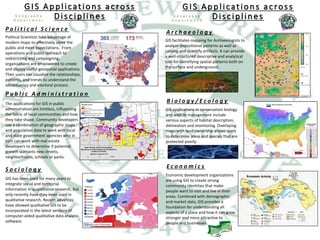
- 1. GIS facilitates mapping for Archaeologists to analyze depositional patterns as well as catalog and quantify artifacts. It can provide a well-structured descriptive and analytical tool for identifying spatial patterns both on the surface and underground. Economic development organizations are using GIS to create strong community identities that make people want to visit and live in their areas. Combined with demographic and market data, GIS provides a foundation for understanding all aspects of a place and how it can grow stronger and more attractive to people and businesses. A r c h a e o l o g y E c o n o m i c s B i o l o g y / E c o l o g y GIS applications in conservation biology and wildlife management include various aspects of habitat description, delineation and monitoring. Overlaying maps with land ownership allows users to determine areas and species that are protected poorly. GIS Applications across Disciplines G e o g r a p h y D e p a r t m e n t Political Scientists take advantage of modern maps to effectively serve the public and meet expectations. From operations and public outreach to redistricting and campaigning, organizations are empowered to create and deploy useful geospatial applications. Then users can visualize the relationships, patterns, and trends to understand the constituency and electoral process. S o c i o l o g y P o l i t i c a l S c i e n c e P u b l i c A d m i n i s t r a t i o n The applications for GIS in public administration are limitless, influencing the fabric of local communities and how they take shape. Community developers use a combination of geographic maps and population data to work with local and state government agencies who in turn can work with real estate developers to determine if potential growth warrants new streets, neighborhoods, schools or parks. GIS has been used for many years to integrate social and territorial information in quantitative research, but only recently have they been used in qualitative research. Recent advances have allowed qualitative GIS to be incorporated in the latest versions of computer-aided qualitative data analysis software. GIS Applications across Disciplines G e o g r a p h y D e p a r t m e n t
- 2. GIS Applications across Disciplines GIS modernizes the approach to health and human services and can transform the health of a community. With GIS and spatial analysis, you can prioritize spending, site service locations, and identify vulnerable populations. The result is better outcomes for patients, stakeholders, and the public. G e o l o g y N u r s i n g / H e a l t h H i s t o r y Geological mapping was a difficult procedure involving multiple complex technologies until researchers discovered the potential of GIS. With the application of GIS in geological mapping, it becomes very easy for surveyors to create 3D maps for any area with precise and desired scaling. An increasing number of historians, particularly those dealing with world history or the history of large geographic regions, are becoming interested in using GIS for research and teaching. Historians deal with processes in complex, nonlinear systems and, therefore, demand a means to organize a large number of variables and identify those variables most likely implicated in the stability and transformation of such systems. G e o g r a p h y D e p a r t m e n t GIS has a long history of driving environmental understanding and decision making. Policymakers, planners, scientists, and many others worldwide rely on GIS for data management and scientific analysis. GIS users represent a vast reservoir of knowledge, expertise, and best practices in applications to climate science, renewable energy, sustainability, and disaster management. G e o g r a p h y E n g i n e e r i n g E n v i r o n m e n t a l S t u d i e s GIS technology provides a central location to conduct spatial analysis, overlay data, and integrate other solutions and systems. When built on a database rather than individual project files, GIS enables engineers to easily manage, reuse, share, and analyze data, saving time and resources. GIS has a foundational home in Geography! Everything that happens, happens in our street, in our town or city, our county, region, state, country and continent. Therefore, we cannot get away from the location issue and consequently, cannot get away from how the things that happen may or may not affect us. Geography is vitally important in our everyday lives and understanding the geography around us is essential. GIS Applications across Disciplines G e o g r a p h y D e p a r t m e n t