GeovisMtStHelens2
•
0 likes•158 views
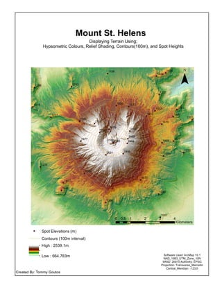
This map shows terrain around Mount St. Helens using hypsometric colors to depict elevation, relief shading to show slopes and terrain, contours at 100m intervals, and spot heights. It was created by Tommy Goutos using ArcMap 10.1 software in NAD 1983 UTM Zone 10N projection. Spot elevations range from 664.783m to 2539.1m.
Report
Share
Report
Share
Download to read offline
Recommended
Zupt, LLC's SLAM and Optimal Sensor fusion
This week at Oceanology Americas we presented a paper on SLAM and Optimal Sensor Fusion and outlined how we have implemented this within our real-time navigation and 3D reconstruction tool, 3D Recon.
We have just assembled two 4,000m rated 3D Recon systems. One of these systems is currently undergoing pressure cycle testing while the other is undergoing extensive burn-in testing to ensure long term viability.
We expect to have test tank data later in March, so if you'd like to receive some sample data sets please let us know at sales@zupt.com.
5. lecture 4 data capturing techniques - satellite and aerial images
Satellite and aerial images can be used to collect cadastral data. Satellite images with resolution of less than 1 meter can be obtained for Ethiopia. Reference points are needed to georeference images and software like ArcGIS can be used to digitize parcel boundaries. While satellite images provide an overview, boundaries drawn from them require field confirmation. Aerial photos provide higher resolution and allow 3D modeling but are more expensive to capture. Both image types require accuracy checking and may be affected by changes, clouds, or obscured borders.
5. lecture 4 data capturing techniques - satellite and aerial images
Satellite and aerial images can be used to collect cadastral data. Satellite images with resolution of less than 1 meter can be obtained for Ethiopia. Reference points are needed to georeference images and software like ArcGIS can be used to digitize parcel boundaries. While satellite images provide an overview, boundaries drawn from them require field confirmation. Aerial photos provide higher resolution but are more expensive to capture. Both image types require ground truthing due to potential errors and changes over time.
Mobile mapping system
Tugas Mata Kuliah Pemetaan Lanjut dari Dr. Ir. Priyono Nugroho, MS
Email ke yanto_budisusanto@yahoo.com atau yanto_b@geodesy.its.ac.id untuk permintaan file
Satellite communication (bett 4803)
This document describes a student assignment to create a MATLAB GUI for a global positioning system (GPS). The objectives are to use MATLAB software to implement a graphic user interface for GPS to determine current satellite location and visibility, and identify which GPS satellites are located nearest to a selected earth station. Key aspects of GPS theory and applications are reviewed, including how GPS satellites transmit signal information to earth and common uses for navigation. Comparisons are made between advantages and disadvantages of GPS. Calculations demonstrate converting GPS coordinates to decimal degrees and feet to meters. Results include sky plots, satellite visibility graphs, dilution of precision values, and elevation plots.
Mobile mapping
Mobile mapping refers to collecting geospatial data using mapping sensors mounted on moving platforms like cars, boats, and airplanes. Mobile mapping systems use GNSS and INS technologies to precisely calculate position, velocity, and orientation in 3D. Time-synchronized navigation sensors integrate with imaging sensors to directly map landscapes, objects, and features. Mobile mapping provides advantages like safety, 24/7 collection, accessibility to otherwise inaccessible areas, and ability to rapidly collect huge amounts of data compared to static scanning. Disadvantages include higher purchase prices and data quantities produced.
Space and Satellites
Satellites are becoming as useful as any other global infrastructure. The main three application: imaging, communications and navigation are expanding very fast paving the way for the "New Space" firms bringing space tourism, space minerals excavation and space fueling to become a reality for humanity
Vehicle Positioning in the Absence of GNSS Signals: Potential of Visual-Inert...
1) Vehicle positioning is important for navigation systems, self-driving cars, and more, but relying on GNSS signals can be problematic in dense urban environments where signals may be blocked.
2) Alternatives to GNSS for local motion estimation include visual odometry, visual-inertial odometry (VIO), and simultaneous localization and mapping (SLAM), but these have issues with drift over time without global position updates.
3) The document evaluates visual-inertial odometry using stereo cameras and inertial measurements, finding it provides continuous positioning with smaller drift and better accuracy than inertial positioning alone or visual odometry.
Gps introduction
The document discusses Global Navigation Satellite Systems (GNSS) such as GPS, GLONASS, Galileo, and Compass. It describes the three main segments of GPS - the space segment consisting of satellites, the ground control segment consisting of ground stations, and the user segment of receivers and applications. It then provides examples of GPS applications in areas such as surveying, agriculture, transportation, and navigation. Differential GPS is also introduced as a technique to improve accuracy by using reference station corrections.
Mission Planning and Execution for the Unmanned Rotorcraft ARTIS
Wrap-up slide deck on functions developed for the Unmanned Rotorcraft ARITS' Mission Planning and Execution Framework (MiPlEx) as well as a preliminary outlook into adaptations to (unmanned) fixed-wing aircraft kinematics.
用光達點雲秀3D
The document discusses point clouds and how they are used. A point cloud is a large set of data points that represent a 3D object or environment. Point clouds can be created from laser scanners, cameras, sonar and other sensors. They provide a precise 3D representation of surfaces and are used in applications such as archaeology, mapping, self-driving cars, and more. The use of point clouds is growing across many industries as a way to efficiently capture 3D spatial data.
Mobile mapping terminology
GNSS systems like GPS use satellites to allow receivers to determine their precise location and time. GPS is the most widely used global satellite navigation system, maintained by the US government for civilian and military use. It consists of space, control, and user segments. The control segment tracks satellites and sends commands, while the space segment transmits navigation signals. The user segment receives signals to calculate position, velocity and time. Other global and regional satellite systems include GLONASS, Galileo, BeiDou and SBAS like EGNOS, which augment GPS accuracy for aviation. SBAS transmit corrections via geostationary satellites to compensate for errors like ionospheric delays.
Introduction to Digital Maps
Starter Guide for Local Government Units (LGUs)
This guide is for Local Government Unit (LGU) readers. The topics contained here are meant to provide information on how Business Mapper products can be applied to your unit.
Galileo gnss
Europe is investing 3.4 billion euros in the Galileo GNSS satellite navigation system to provide an alternative to the US GPS system. Galileo will consist of 30 satellites providing global coverage with better accuracy of over 1 meter. It will offer several services like open service, safety of life service, commercial service, and search and rescue. The system is expected to generate 10 billion euros annually and create 100,000 new jobs in Europe.
Lesson 1. OPENSTREETMAP Basic Operations
OpenStreetMap (OSM) is a collaborative mapping platform where users can create and edit maps. OSM data is freely available and can be downloaded for use. The document provides an overview of OSM, how to access and set up an account, navigate the interface, add map features through tracing in editing mode, and save edits with descriptive change comments. Key aspects covered include using OSM to strengthen community resilience, different map styles, and adding extra details to mapped locations.
GPS(Global Positioning System)
The GPS system was developed by the US Department of Defense to provide accurate positioning globally using triangulation of signals from multiple satellites. It consists of three segments - the space segment with satellites, control segment with monitoring stations, and user segment with receivers. GPS provides military and civilian navigation capabilities and is used in applications like mapping, robotics, and surveying. Other countries have also developed or are developing their own satellite navigation systems.
Location Intelligence from Imagery
This document discusses using geospatial imagery for location intelligence. It describes different types of imagery like satellite, drone, and street-level images. Intelligence can be derived from imagery by extracting features, detecting changes, and regular monitoring. Examples are given of using deep learning for feature extraction from satellite imagery and generating building footprints. Facebook and Microsoft have used AI to generate road maps from imagery which are then reviewed and added to OpenStreetMap. Street-level imagery from Mapillary also helps map features.
Mapping Water features from SAR Imagery
mapping water features using radar SAR imagery, example using ALOS PALSAR RTC Product, free download at ASF VERTEX
Engineering survey in the construction industry
This document discusses the role and responsibilities of survey engineers in Kenya. It states that survey engineers are instrumental at both the design and completion stages of projects. In Kenya, survey engineers are often seen as field workers and can be excluded from important project decisions if they are not careful. The document then outlines some key responsibilities of survey engineers, such as topographical surveys, monitoring infrastructure and utilities, setting out project sites, and establishing land boundaries. It also lists common tools used by survey engineers like GPS systems, total stations, levels, and software. Survey control, topographical surveys, earthworks calculations, and mass haul diagrams are also summarized.
Mockup mobile.map.geo.admin.ch
Feature list of release 1 mobile mapping solution. Release date Q3 2011, mor info on www.geo.admin.ch
MWC/ADC 2013 Mapping and Location for Windows Phone
In this MWC/ADC 2013 presentation Vaughan Knight, Developer Technical Support Manager at Nokia, provides an overview to the new mapping and location features in Windows Phone 8. These features include a new map control that no longer requires a key, support for offline maps, and pedestrian landmark among others. He then looks at coding map and location apps with the new control and geolocator before showing you how to launch Nokia Direction and Nokia drive from your app as well as use the offline features.
For more information see www.developer.nokia.com/windowsphone or http://www.developer.nokia.com/Resources/Library/Lumia/#!guide-to-the-wp8-maps-api.html.
Find out more about the developer features of Nokia Lumia smartphones in the Lumia App Labs: http://www.developer.nokia.com/Develop/Windows_Phone/Learn/
Floods & Landslides
Links are given for amazing videos on Floods and Landslides. A project for Remote Sensing and GIS Applications...
Mapping wild species in Jabal Samhan Nature Reserve, Oman.
The document summarizes a capstone project that mapped wild species in the Jabal Samhan Nature Reserve in Oman using GIS. The project created offline maps showing locations of 14 species, an online story map of the species, and 3D maps on ArcGIS Online and Google Earth. The conclusions compare the 3D mapping options and note the story map and 3D Scene on ArcGIS Online are publicly available while Google Earth requires data conversion and login. The overall goal was to create different map formats displaying species locations in the nature reserve.
Columbus - map creation using gps locations
Columbus is a system created by Go-Jek to build their own digital map and calculate shortest paths using driver GPS location data collected every 10 seconds. The GPS data is clustered and centroids are used as nodes to create a directional graph representing the road network. Shortest paths between nodes can then be found to allocate the nearest driver to customers. Key challenges include processing the large volume of GPS data, dealing with location inaccuracies, identifying clusters, and determining the directional connections between nodes to accurately represent the road network.
Arc Geographic Information System (GIS) Digital Elevation Models (DEM).
This presentation discuss about Arc Geographic Information System (GIS) Digital Elevation Models (DEM). DEM data sources.
3D Animation
The document outlines a 3D animation and visualization system with the following components:
1. The VTP platform is used to model terrain and simple structures.
2. Weather engines simulate wind, rain, clouds, lightning, and trees moving in the wind.
3. Ocean engines create waves and storm surge flooding along the coastline using particle systems and animated meshes.
4. A traffic system represents roads and vehicles that respond to flooding.
Modern Surveying
The document discusses the topic of surveying. It provides an overview of the history and evolution of surveying, from its beginnings in ancient Egypt to modern techniques using tools like total stations and GPS. Some key points covered include the various types and categories of surveying work, the traditional equipment used, and how modern digital instruments like total stations integrate distance measurement and angle measurement capabilities into one device.
CasinoMine
This document contains 25 maps showing the results of a slope analysis along a proposed road alignment for the Casino Mine. Each map displays terrain information like slope classification, contour lines, and terrain units covering a 1:20,000 scale area. Key details like the mine name, map number, source information, and a legend are consistently provided on each page.
NewfoundlandProject3
The document is a map of Newfoundland, Canada highlighting various locations relevant to tourism. Key places shown on the map include St. John's, Corner Brook, Gros Morne National Park, Terra Nova National Park, and many smaller towns along the coast. Symbols on the map indicate different attractions, amenities and transportation routes available for tourists visiting Newfoundland.
GPSvsSurveyFINAL
This map shows surveyed and GPS data collected at the Emily Landfill site. Contours and locations of roads, lagoons, and a mound are shown. Surveyed well locations are compared to those collected by GPS. The landfill is identified as located on Lot 12, Concession 8 in the former Township of Emily in the City of Kawartha Lakes.
More Related Content
What's hot
Gps introduction
The document discusses Global Navigation Satellite Systems (GNSS) such as GPS, GLONASS, Galileo, and Compass. It describes the three main segments of GPS - the space segment consisting of satellites, the ground control segment consisting of ground stations, and the user segment of receivers and applications. It then provides examples of GPS applications in areas such as surveying, agriculture, transportation, and navigation. Differential GPS is also introduced as a technique to improve accuracy by using reference station corrections.
Mission Planning and Execution for the Unmanned Rotorcraft ARTIS
Wrap-up slide deck on functions developed for the Unmanned Rotorcraft ARITS' Mission Planning and Execution Framework (MiPlEx) as well as a preliminary outlook into adaptations to (unmanned) fixed-wing aircraft kinematics.
用光達點雲秀3D
The document discusses point clouds and how they are used. A point cloud is a large set of data points that represent a 3D object or environment. Point clouds can be created from laser scanners, cameras, sonar and other sensors. They provide a precise 3D representation of surfaces and are used in applications such as archaeology, mapping, self-driving cars, and more. The use of point clouds is growing across many industries as a way to efficiently capture 3D spatial data.
Mobile mapping terminology
GNSS systems like GPS use satellites to allow receivers to determine their precise location and time. GPS is the most widely used global satellite navigation system, maintained by the US government for civilian and military use. It consists of space, control, and user segments. The control segment tracks satellites and sends commands, while the space segment transmits navigation signals. The user segment receives signals to calculate position, velocity and time. Other global and regional satellite systems include GLONASS, Galileo, BeiDou and SBAS like EGNOS, which augment GPS accuracy for aviation. SBAS transmit corrections via geostationary satellites to compensate for errors like ionospheric delays.
Introduction to Digital Maps
Starter Guide for Local Government Units (LGUs)
This guide is for Local Government Unit (LGU) readers. The topics contained here are meant to provide information on how Business Mapper products can be applied to your unit.
Galileo gnss
Europe is investing 3.4 billion euros in the Galileo GNSS satellite navigation system to provide an alternative to the US GPS system. Galileo will consist of 30 satellites providing global coverage with better accuracy of over 1 meter. It will offer several services like open service, safety of life service, commercial service, and search and rescue. The system is expected to generate 10 billion euros annually and create 100,000 new jobs in Europe.
Lesson 1. OPENSTREETMAP Basic Operations
OpenStreetMap (OSM) is a collaborative mapping platform where users can create and edit maps. OSM data is freely available and can be downloaded for use. The document provides an overview of OSM, how to access and set up an account, navigate the interface, add map features through tracing in editing mode, and save edits with descriptive change comments. Key aspects covered include using OSM to strengthen community resilience, different map styles, and adding extra details to mapped locations.
GPS(Global Positioning System)
The GPS system was developed by the US Department of Defense to provide accurate positioning globally using triangulation of signals from multiple satellites. It consists of three segments - the space segment with satellites, control segment with monitoring stations, and user segment with receivers. GPS provides military and civilian navigation capabilities and is used in applications like mapping, robotics, and surveying. Other countries have also developed or are developing their own satellite navigation systems.
Location Intelligence from Imagery
This document discusses using geospatial imagery for location intelligence. It describes different types of imagery like satellite, drone, and street-level images. Intelligence can be derived from imagery by extracting features, detecting changes, and regular monitoring. Examples are given of using deep learning for feature extraction from satellite imagery and generating building footprints. Facebook and Microsoft have used AI to generate road maps from imagery which are then reviewed and added to OpenStreetMap. Street-level imagery from Mapillary also helps map features.
Mapping Water features from SAR Imagery
mapping water features using radar SAR imagery, example using ALOS PALSAR RTC Product, free download at ASF VERTEX
Engineering survey in the construction industry
This document discusses the role and responsibilities of survey engineers in Kenya. It states that survey engineers are instrumental at both the design and completion stages of projects. In Kenya, survey engineers are often seen as field workers and can be excluded from important project decisions if they are not careful. The document then outlines some key responsibilities of survey engineers, such as topographical surveys, monitoring infrastructure and utilities, setting out project sites, and establishing land boundaries. It also lists common tools used by survey engineers like GPS systems, total stations, levels, and software. Survey control, topographical surveys, earthworks calculations, and mass haul diagrams are also summarized.
Mockup mobile.map.geo.admin.ch
Feature list of release 1 mobile mapping solution. Release date Q3 2011, mor info on www.geo.admin.ch
MWC/ADC 2013 Mapping and Location for Windows Phone
In this MWC/ADC 2013 presentation Vaughan Knight, Developer Technical Support Manager at Nokia, provides an overview to the new mapping and location features in Windows Phone 8. These features include a new map control that no longer requires a key, support for offline maps, and pedestrian landmark among others. He then looks at coding map and location apps with the new control and geolocator before showing you how to launch Nokia Direction and Nokia drive from your app as well as use the offline features.
For more information see www.developer.nokia.com/windowsphone or http://www.developer.nokia.com/Resources/Library/Lumia/#!guide-to-the-wp8-maps-api.html.
Find out more about the developer features of Nokia Lumia smartphones in the Lumia App Labs: http://www.developer.nokia.com/Develop/Windows_Phone/Learn/
Floods & Landslides
Links are given for amazing videos on Floods and Landslides. A project for Remote Sensing and GIS Applications...
Mapping wild species in Jabal Samhan Nature Reserve, Oman.
The document summarizes a capstone project that mapped wild species in the Jabal Samhan Nature Reserve in Oman using GIS. The project created offline maps showing locations of 14 species, an online story map of the species, and 3D maps on ArcGIS Online and Google Earth. The conclusions compare the 3D mapping options and note the story map and 3D Scene on ArcGIS Online are publicly available while Google Earth requires data conversion and login. The overall goal was to create different map formats displaying species locations in the nature reserve.
Columbus - map creation using gps locations
Columbus is a system created by Go-Jek to build their own digital map and calculate shortest paths using driver GPS location data collected every 10 seconds. The GPS data is clustered and centroids are used as nodes to create a directional graph representing the road network. Shortest paths between nodes can then be found to allocate the nearest driver to customers. Key challenges include processing the large volume of GPS data, dealing with location inaccuracies, identifying clusters, and determining the directional connections between nodes to accurately represent the road network.
Arc Geographic Information System (GIS) Digital Elevation Models (DEM).
This presentation discuss about Arc Geographic Information System (GIS) Digital Elevation Models (DEM). DEM data sources.
3D Animation
The document outlines a 3D animation and visualization system with the following components:
1. The VTP platform is used to model terrain and simple structures.
2. Weather engines simulate wind, rain, clouds, lightning, and trees moving in the wind.
3. Ocean engines create waves and storm surge flooding along the coastline using particle systems and animated meshes.
4. A traffic system represents roads and vehicles that respond to flooding.
Modern Surveying
The document discusses the topic of surveying. It provides an overview of the history and evolution of surveying, from its beginnings in ancient Egypt to modern techniques using tools like total stations and GPS. Some key points covered include the various types and categories of surveying work, the traditional equipment used, and how modern digital instruments like total stations integrate distance measurement and angle measurement capabilities into one device.
What's hot (19)
Mission Planning and Execution for the Unmanned Rotorcraft ARTIS
Mission Planning and Execution for the Unmanned Rotorcraft ARTIS
MWC/ADC 2013 Mapping and Location for Windows Phone
MWC/ADC 2013 Mapping and Location for Windows Phone
Mapping wild species in Jabal Samhan Nature Reserve, Oman.
Mapping wild species in Jabal Samhan Nature Reserve, Oman.
Arc Geographic Information System (GIS) Digital Elevation Models (DEM).
Arc Geographic Information System (GIS) Digital Elevation Models (DEM).
Viewers also liked
CasinoMine
This document contains 25 maps showing the results of a slope analysis along a proposed road alignment for the Casino Mine. Each map displays terrain information like slope classification, contour lines, and terrain units covering a 1:20,000 scale area. Key details like the mine name, map number, source information, and a legend are consistently provided on each page.
NewfoundlandProject3
The document is a map of Newfoundland, Canada highlighting various locations relevant to tourism. Key places shown on the map include St. John's, Corner Brook, Gros Morne National Park, Terra Nova National Park, and many smaller towns along the coast. Symbols on the map indicate different attractions, amenities and transportation routes available for tourists visiting Newfoundland.
GPSvsSurveyFINAL
This map shows surveyed and GPS data collected at the Emily Landfill site. Contours and locations of roads, lagoons, and a mound are shown. Surveyed well locations are compared to those collected by GPS. The landfill is identified as located on Lot 12, Concession 8 in the former Township of Emily in the City of Kawartha Lakes.
Ontario
The document provides data on the population of Ontario including the percentage of citizens whose mothertongue is French or English according to census divisions. It shows that 28% of citizens' mothertongue is French and the remaining 72% is English. It also includes a map of Ontario divided into census divisions displaying the total population ranges in each division from 13050 to 2615060.
DEMFINAL
This document is a map of the Emily Landfill showing elevation contours and approximate locations of lagoons, mounds, and roads. The map was created from total station survey data and ArcGIS layers in UTM NAD 83 zone 17 coordinate system at a scale of 1:1,600. It was produced by JMTConsultants for Project Group #775 and includes data source and disclaimer information.
OverlayedGoogleFINAL
This document contains elevation data from a survey of the Emily Landfill. It lists elevation readings and provides metadata on the data source and disclaimer. The data was collected via total station survey in UTM NAD 83 zone 17. Locations of lagoons, mounds and roads on the map are approximate as no benchmarks were used.
3DMap
This document contains 3D images from ArcScene showing aerial views of digital elevation models for ground elevation, clay layer thickness, and water table elevation for the Emily landfill site. The layers were used in ArcMap to calculate the volume of refuse and clay for the mound at the Emily landfill site.
Viewers also liked (7)
GeovisMtStHelens2
- 1. 2445 2146 2341 1533 1489 1272 2111 1573 1227 1276 1977 1404 1357 2464 1577 1398 1445 1620 1263 1156 1377 2531 1589 1290 1350 1409 1322 1391 1410 2322 2465 1835 2168 1467 1057 1580 1286 1318 1405 1613 Mount St. Helens Displaying Terrain Using; Hypsometric Colours, Relief Shading, Contours(100m), and Spot Heights ¯ 0 1 2 3 40.5 Kilometers Created By: Tommy Goutos Software Used: ArcMap 10.1 NAD_1983_UTM_Zone_10N WKID: 26910 Authority: EPSG Projection: Transverse_Mercator Central_Meridian: -123.0 Spot Elevations (m) Contours (100m interval) High : 2539.1m Low : 664.783m