Download as PDF, PPTX

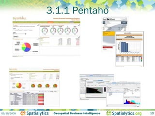
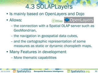
![4.2.1 Spatially enabled MDX
• bring to Mondrian and MDX what SQL spatial
extensions do for relational DBMS (i.e. Simple
Features for SQL and implementations such as
PostGIS).
• Example query: filter spatial dimension members
based on distance from a feature
– SELECT
{[Measures].[Population]} on columns,
Filter(
{[Unite geographique].[Region economique].members},
ST_Distance([Unitegeographique].CurrentMember.Properties("geom"),
[Unite geographique].[Province].[Ontario].Properties("geom")) < 2.0
) on rows
FROM [Recensements]
WHERE [Temps].[Rencensement 2001 (2001-2003)].[2001]
06/10/2009 Geospatial Business Intelligence 26](https://image.slidesharecdn.com/211014h55verdun1036-091228134948-phpapp02/85/GeoKettle-GeoMondrian-et-Spatialytics-une-suite-open-source-de-GeoBI-26-320.jpg)


The document outlines the benefits and offerings of open-source geospatial business intelligence (geo-BI) solutions developed by Spatialytics, led by CEO Luc Vaillancourt and CTO Dr. Thierry Badard. It discusses the growth of the business intelligence market, the importance of open-source software, and highlights tools like Geokettle, Geomondrian, and Solaplayers that facilitate data integration and analysis. The presentation showcases Spatialytics' core projects that enhance the capabilities of traditional BI by incorporating geospatial data processing.


