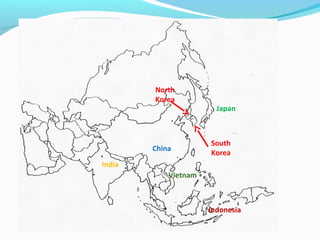
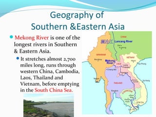
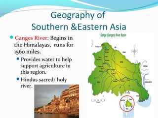
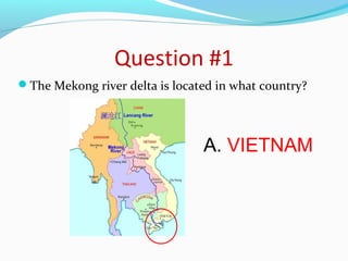
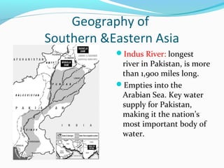
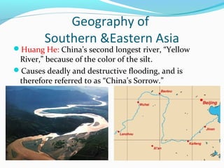
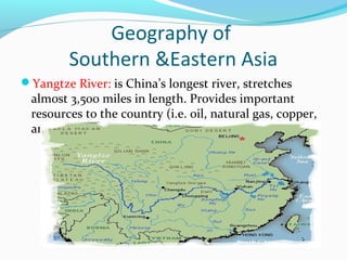
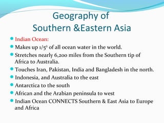
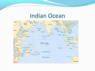
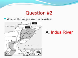
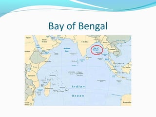
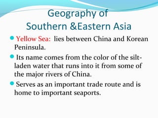
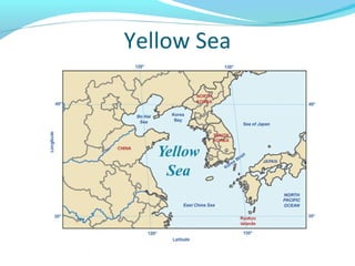
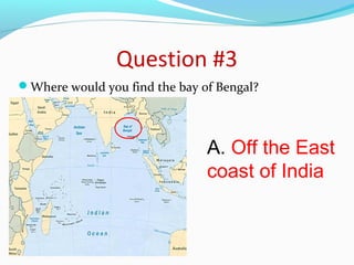
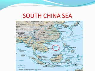
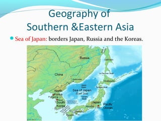
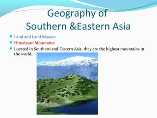
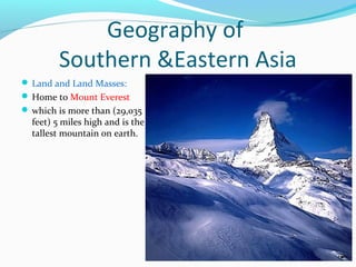
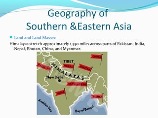
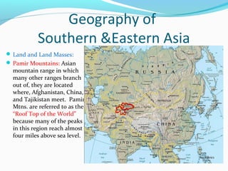
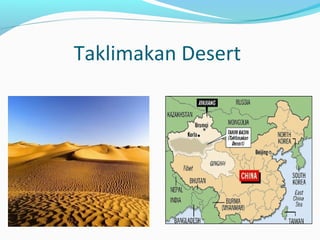
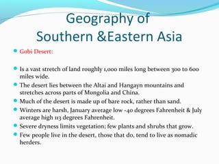
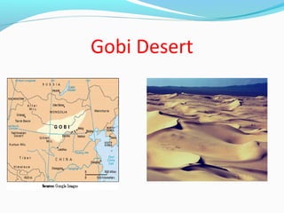
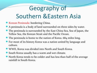
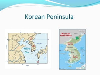
The document discusses the geography of Southern and Eastern Asia. It describes several major rivers that run through the region like the Mekong River and Ganges River. It also discusses large deserts like the Taklimakan Desert and Gobi Desert. Mountains ranges are also covered, such as the Himalayas. Bodies of water including the South China Sea, Yellow Sea, and Bay of Bengal are identified. The population distribution is impacted by geography, with many people living near coasts, rivers, and in cities for resources and trade. Pollution is a rising issue from increased development.
A comprehensive powerpoint on the geography of the Southeast Asian region. This was completed for a masters level course and is intended for community college or high school students. Includes many case studies from throughout Southeas Asia.
India is one of the ancient civilizations in the
world. It has achieved multi faceted socioeconomic
progress during the last five decades.
It has moved forward displaying
remarkable progress in the field of
agriculture, industry, technology and overall
economic development. India has also
contributed significantly.
ppt of ch-6 class6 Geography major landforms of the Earth PoonamMudaliar
This is class 6 ,chapter-6, Major
landforms of the Earth,Chhattisgarh board, Geography ppt .
This is useful for teachers and student's and also b.ed students who want to summit assignments of b.ed. parcticums.
The presentation is about the different water forms on Earth. You can use the presentation for your class if you are a teacher and if your are a student, you can use this as a form of reviewer and something to study on. You can also use this if you are given a task to report about the different water forms on Earth. The slide will sure to capture the eyes of the viewer/reader. Enjoy using the slide presentation and I am hoping you will learn something on this particular presentation.
Asian Cultural TraditionsChapter 1 Asia as cultured placeThe .docxfestockton
Asian Cultural Traditions
Chapter 1: Asia as cultured place
The chapter commences with provision of physical map of Asia and touches three main countries and that is India, china and japan. China is thought to be largest but when compared to the India, it is small land on the periphery of Jambu. Japan on the other hand is a central land in the ocean.
The region is very rich in terms of culture and has both sacred and political cultural meaning and as per description of Chikafusa play the central importance.
The author also illustrate in detail how the country or the continents were formed from a disaster caused by slow motion collision of India and Eurasia.
It is quite clear that the formation of these countries was a result of natural disasters which separated them. The Collison altered landforms through compressing and distorting earth crust.
There are authorities in charge and people are practices farming and livestock keeping as they engaged in trade and they experienced conflict especially in boundary areas. Several concepts also emerges out of this landforms and they include
Rivers
These regions cannot be defined effectively without looking at the water bodies. One of them are rivers which are said to have one source.
The great collision divides china into region and that is north and south china where two rivers which are Huanghe and Yangzi. North China is known for winter, wheat production and people struggling with life through powdery soil.
South China on the other hand, has enough rainfall, green land, full of bamboo, water buffalo, tea and rice.
River Huanghe or the yellow river seems to be a problematic to the people instead of benefitting them and the main problem is that the river breaks its bank and farmers are affected by the floods. It has been the duty of the government to construct dikes that will prevent flood from reaching the farmers.
Yangzi on the other hand is a blessing to the country since it has commercial benefits and it has contributed to development of the major cities like shanghai.
These two rivers only flowed from west to east and rulers decided to create rivers that world flow from north to south of china for more economic benefits especially in growing rice.
Apart from economic benefit, the rivers have cultural impact and Hindus for instance do not only bath in river Ganges for dirt purposes but also cleanse their sins in the holy water.
The Outer Ring of Islands
In the southeast of Asia, there are group of islands which make up the Philippines and Indonesia. All these islands emerge due to volcanism taking place and split the land although thousands of people lose their lives.
At the end, several islands are formed and they include Singapore, Malaysia, Sulawesi, Sumatra, Bali and others.
The only benefit of these volcano eruptions is fertile soils which attracts people to settle for agriculture purposes.
Before looking at the life of people in the region, the author discusses another imp ...
3. Geography of
Southern &Eastern Asia
Mekong River is one of the
longest rivers in Southern
& Eastern Asia.
It stretches almost 2,700
miles long, runs through
western China, Cambodia,
Laos, Thailand and
Vietnam, before emptying
in the South China Sea.
4. Geography of
Southern &Eastern Asia
Ganges River: Begins in
the Himalayas, runs for
1560 miles.
Provides water to help
support agriculture in
this region.
Hindus sacred/ holy
river.
5. Question #1
The Mekong river delta is located in what country?
A. VIETNAM
6. Geography of
Southern &Eastern Asia
Indus River: longest
river in Pakistan, is more
than 1,900 miles long.
Empties into the
Arabian Sea. Key water
supply for Pakistan,
making it the nation’s
most important body of
water.
7. Geography of
Southern &Eastern Asia
Huang He: China’s second longest river, “Yellow
River,” because of the color of the silt.
Causes deadly and destructive flooding, and is
therefore referred to as “China’s Sorrow.”
8. Geography of
Southern &Eastern Asia
Yangtze River: is China’s longest river, stretches
almost 3,500 miles in length. Provides important
resources to the country (i.e. oil, natural gas, copper,
and iron ore).
9. Geography of
Southern &Eastern Asia
Indian Ocean:
Makes up 1/5th of all ocean water in the world.
Stretches nearly 6,200 miles from the Southern tip of
Africa to Australia.
Touches Iran, Pakistan, India and Bangladesh in the north.
Indonesia, and Australia to the east
Antarctica to the south
African and the Arabian peninsula to west
Indian Ocean CONNECTS Southern & East Asia to Europe
and Africa
12. Geography of
Southern &Eastern Asia
Bay of Bengal: lies to the northeast of
the Indian Ocean.
Serves as a major fishery for the
people in this region.
Also provides ports for shipping and
has been an important body of water
for international trade.
14. Geography of
Southern &Eastern Asia
Yellow Sea: lies between China and Korean
Peninsula.
Its name comes from the color of the silt-laden
water that runs into it from some of
the major rivers of China.
Serves as an important trade route and is
home to important seaports.
16. Question #3
Where would you find the bay of Bengal?
A. Off the East
coast of India
17. Geography of
Southern &Eastern Asia
South China Sea: bordered by the Taiwan Strait,
Taiwan, the Philippines, Borneo, the Gulf of Thailand,
the Malay Peninsula, and the Asian mainland.
Provides seafood for many of the people of East Asia.
Monsoons blow across the sea , greatly affecting, life
in this region.
Also plays a crucial role in travel and trade.
19. Geography of
Southern &Eastern Asia
Sea of Japan: borders Japan, Russia and the Koreas.
20. Geography of
Southern &Eastern Asia
Land and Land Masses:
Himalayan Mountains:
Located in Southern and Eastern Asia, they are the highest mountains in
the world.
21. Geography of
Southern &Eastern Asia
Land and Land Masses:
Home to Mount Everest
which is more than (29,035
feet) 5 miles high and is the
tallest mountain on earth.
22. Geography of
Southern &Eastern Asia
Land and Land Masses:
Himalayas stretch approximately 1,550 miles across parts of Pakistan, India,
Nepal, Bhutan, China, and Myanmar.
23. Geography of
Southern &Eastern Asia
Land and Land Masses:
Pamir Mountains: Asian
mountain range in which
many other ranges branch
out of, they are located
where, Afghanistan, China,
and Tajikistan meet. Pamir
Mtns. are referred to as the
“Roof Top of the World”
because many of the peaks
in this region reach almost
four miles above sea level.
24. Geography of
Southern &Eastern Asia
Deserts:
Taklimakan Desert:
The Taklimakan Desert in northwest China is a vast region of sand desert
sitting in a depression between two high, rugged mountain ranges.
the Taklimakan's rolling sand dunes stretch out over about 125,000 square
miles in the Xinjiang region of China.
The desert is hemmed in to the north by the snow-covered Tien Shan
Mountain range and to the south by the rugged Kunlun Mountains.
Desertification and shifting sand dunes are a major concern for the farmers
and grazers who live at the desert's edge.
26. Geography of
Southern &Eastern Asia
Gobi Desert:
Is a vast stretch of land roughly 1,000 miles long between 300 to 600
miles wide.
The desert lies between the Altai and Hangayn mountains and
stretches across parts of Mongolia and China.
Much of the desert is made up of bare rock, rather than sand.
Winters are harsh, January average low -40 degrees Fahrenheit & July
average high 113 degrees Fahrenheit.
Severe dryness limits vegetation; few plants and shrubs that grow.
Few people live in the desert, those that do, tend to live as nomadic
herders.
28. Geography of
Southern &Eastern Asia
Korean Peninsula: bordering China.
A peninsula is a body of land surrounded on three sides by water.
The peninsula is surrounded by the East China Sea, Sea of Japan, the
Yellow Sea, the Korean Strait and the Pacific Ocean.
The peninsula is home to the nation of Korea. 684 miles long.
For most of its history Korea was a nation united by language and
culture.
WWII, Korea was divided into North and South Korea.
South Korea usually has a warm and wet climate.
North Korea tends to be colder and has less than half of the average
rainfall in South Korea.
30. Question of the day:
How does the geography impact the
population distribution of
Southern and Eastern Asia?
Take a few moments and develop
an answer to this question on
your paper.
31. India—
India is a subcontinent- which
is a large landmass that is
smaller than a continent
India has a population of more
than 1 billion people.
Most of the population is located
in cities, where they live in
shacks and struggle to make a
living. Most of the major cities
face overpopulation
The other parts of the population
live in rural areas where they
work as farmers and live with
their extended family in simple
houses
32. China-
The majority of the
population in China lives on
the eastern coast.
Most of the people live in
small, rural villages and
work as farmers.
China’s urban, or city,
population is also on the
rise because of the growing
number of industries and
trading taking place. Most
of these urban cities are
located along the coast or
major rivers.
33. JAPAN-Has
one of the world’s strongest fishing economies
It is a densely populated country (smaller than California with almost
four times the population)
Most of these people live in crowded cities! For example: Space is so
limited in Tokyo that they have started building underground.
Others live in rural villages where they work on farms.
Problem with this is that most of the land in Japan is not arable.–
this is why the cities are so crowded!!!!! Most of Japan’s food is
imported
34. Koreas-
North Korea has large deposits of coal, iron, and other
minerals– making it very rich in resources
South Korea and Japan are not so lucky
Both Koreas use their land to generate electricity
Most of the people in South and North Korea tend to
live in cities
South Korea most of those cities are located along the coast.
Very few people live in the rugged interior.
Life for people in the cities of North Korea is very different
from that of people in South Korea. (NK= No cars, no rights,
electricity shortages)
36. Vietnam-
Vietnam occupies the eastern and
southern part of the Indochina
peninsula in Southeast Asia, with
the South China Sea along its entire
coast.
Vietnam is about twice the size of
Arizona. The Mekong River delta
lies in the south.
Besides rice, key exports are coffee,
tea, rubber, and fisheries products.
The Government is also in the
process of "equitizing" (e.g.,
transforming state enterprises into
share holding companies and
distributing a portion of the shares
to management, workers and
private foreign and domestic
investors)
37. Causes of Pollution
• China’s and India’s economic and urban growth has caused
serious issues for the environment.
• Seven of the ten most polluted cities are located in China.
• And India’s more than 1 billion people make it the second
most populous country behind China
– Pollution-
• Caused by the increased number of cars and
factories and also the burning of coal for electricity
in China.
38. Effects of Pollution
Many nations in South, Southeast, and East Asia will
now have to worry about the “Asian Brown Cloud”
caused by too much pollution in the air.
*causes: waste from factories, motor vehicles, forest
fires, etc.
.
39. Effects of Pollution
* It is a brown haze that can alter the paths of
monsoons, reduce photosynthesis, increase human
respiratory problems, and reduces solar radiation to
the earth’s surface.
40. Solutions to Population
In China they have instituted the “one-child-per-family
policy of 1979”.
This states that any couple that has only one child will
receive economic and educational benefits, while
couples that have more than one child will have to pay
fines.
41. Pollution on the Yangtze
Large amounts of waste are dumped in the Yangtze
each year causing massive pollution.
Much of this waste comes from mineral fertilizers
used in farming, factory waste, and also shipping.
Effects of pollution:
Contaminated drinking water
42. Pollution on the Ganges
The Ganges river, which is a holy river to many
people that live in India, has also seen a tremendous
rise in pollution over the last several years.
Most of the pollution found in the Ganges comes
from organic waste (sewage, trash, food, and human
as well as animal remains)
The increase in India’s population is the cause of all this
waste– the sewage systems are not up to date
43. Effects of pollution on the Ganges
Because the Ganges is a
sacred river to many
Hindus- and there is a
sacred practice of
depositing human
remains….
the river has become
infected with many water-borne
diseases (hepatitis,
typhoid or cholera)
causing much of the
population to become
infected with these diseases