This study analyzed fracture-filling saddle dolomite cement from Devonian and Mississippian carbonate reservoirs in western Canada to understand the fluids involved in dolomitization. Isotopic and fluid inclusion data found evidence for two hydrothermal fluid pulses: an early pulse related to the Antler Orogeny dolomitized Devonian reservoirs, while a late pulse during the Laramide Orogeny dolomitized Mississippian reservoirs. Devonian saddle dolomite showed more depleted oxygen isotopic values, higher 87Sr/86Sr ratios, and higher fluid inclusion temperatures and salinities, indicating a more radiogenic and hotter hydrothermal fluid. Spatial variations within the basins also suggested compartmentalization of hydro
Distinguishing gas bearing sandstone reservoirs within mixed siliciclastic-ca...Ahmed Hafez
Seismic AVO analysis of the mixed clastics and carbonate sequences to distinguish the gas sandstone in the Nile Delta basin, offshore Mediterranean Sea. Rock physics analysis is also included. Extended elastic impedance inversion also applied. Nile Delta seismic reservoir characterization workflow
Formation And Occurrences Of Laumontite And Related Minerals In The Carolinas...STAR Environmental
The document summarizes the widespread occurrence of laumontite zeolite formation in rocks across parts of the southern Appalachians between 175-150 million years ago. Laumontite forms as fracture fillings and replacements of plagioclase feldspar in pre-Jurassic igneous and metamorphic rocks. Hot waters circulating through fractures during rifting and volcanic activity metamorphosed the rocks to zeolite grade, crystallizing laumontite and other minerals. Over 100 sites across North Carolina, South Carolina, Georgia and Virginia contain laumontite occurrences in outcrops and subsurface rocks.
1) Arsenic contamination of groundwater in Southeast Asia affects tens of millions of people. The document examines the source and transport of arsenic in the Mekong Delta of Cambodia, which has experienced minimal human disturbance.
2) Field measurements show arsenic is released from near-surface river-derived sediments under anaerobic conditions and transported through the underlying aquifer over centuries to the river.
3) The rates of arsenic influx via sediment deposition and efflux via groundwater transport are comparable, indicating release from solids and transport through the aquifer are in balance.
The document discusses depositional models for coal exploration and mine planning in the Appalachian region. It finds that the depositional environment of coal beds strongly influences characteristics like thickness, continuity, roof conditions, and coal quality. Coals formed in back-barrier environments tend to be thin, discontinuous, high in sulfur, and have severe roof problems. Coals in the lower delta plain are more widespread but also thin and show irregular sulfur distribution. Coals in the upper delta plain-fluvial environment are thicker, lower in sulfur, but often discontinuous. Most important coals in the region formed in the transitional zone between the lower and upper delta plains, where coals can be thick and laterally continuous with low
This honours project examined the coal seam interburden at Caval Ridge Coal Mine to determine the likely depositional environment. The author analyzed highwalls, maps, borehole geophysics, core images, and outcrop photos. Two possible depositional environments were identified for sedimentary features in the interburden - crevasse splays from deltas or point bars from channels. Key differences between these were examined to interpret the environment. The study area was found to possibly be part of a larger distributive fluvial system characterized by numerous contemporaneous channels that prograded over time.
Crystal Lake Mining: TECHNICAL HIGHLIGHTS OF THE NICOBAT PROJECT: A PIPELINE ...MomentumPR
Crystal Lake Mining is a Canada-based junior exploration company focused on building shareholder value through the discovery of new magmatic nickel sulphide deposits using technical excellence in exploration target development.
The document summarizes the natural and human-induced geological processes affecting the Cardona Diapir salt outcrop in northeastern Spain. It describes the formation and geological structure of the salt deposit. Underground mining for potassium salt from 1930 to 1990 caused significant changes, including the accumulation of mine waste that dammed drainage and induced sinkhole formation. In 1998, the interception of an underground salt conduit by a mine gallery dramatically altered the hydrology and caused river water and debris to flow into the mine.
Fault Tectonics of the NE Black Sea Shelf and Its Relevance to Hydrocarbon Po...Şarlatan Avcısı
Abstract
Although faults of the consolidated crust play crucial role in the origin of sedimentary features and hydrocarbon accumulation, the tectonic setting of the NE Black Sea shelf is poorly known. The aim of this work is to compile the most detailed map of faults in the consolidated crust and test comprehensively a linkage between crustal disturbances and potential hydrocarbon features. Understanding such a relationship may be helpful in planning location of exploration boreholes.
For the first time, 3D gravity and magnetic models have been obtained at a scale of 1:200,000 for the NE Black Sea shelf. Based on the analysis of the observed magnetic field and gravity effect of the consolidated crust, the most detailed map has bееn compiled for tectonic faults of the consolidated crust. The relationship has been derived between the crustal and sedimentary faults. The prospective local anticlinal features have been revealed to be associated with certain systems of tectonic disturbances in the different crustal layers and magnetic inhomogeneity in the crust. The magnetic bodies of the consolidated crust and sedimentary cover can be of common origin due to
the influence of hydrocarbons vertically migrating along the deep faults. An individual block of high density has been delimited by the faults in the consolidated crust where there occur practically all prospective hydrocarbon features. The southern margin of this block is recommended as a new potential area for oil and gas exploration where gas seeps
are genetically related to the tectonic disturbances of different orders.
A first model has been derived for thermal evolution of the Kerch-Taman Trough from the pseudo-well method. A total subsidence of its basement can reach 5.0-6.5 km. The present-day temperature vs. depth profiles have been calculated. A thermal and stratigraphic position
has been determined for zones of oil and gas origin.
source : V.I. Starostenko1, B.L. Krupskyi1, I.K. Pashkevich1, O.M. Rusakov1,
I.B. Makarenko1, R.I. Kutas1, V.V Gladun1, O.V. Legostaeva1, T.V. Lebed1, and
P.Ya. Maksymchuk1
Search and Discovery Article #30155 (2011) Posted March 28, 2011
*Adapted from oral presentation at AAPG European Region Annual Conference, Kiev, Ukraine, October 17-19, 2010
1Institute of Geophysics, National Academy of Sciences of Ukraine, National Joint stock-Company Naftogaz of Ukraine, Kyiv, Ukraine
The Boltysh crater fill sediments – a 500,000 year record of the lower DanianIain Gilmour
The document summarizes research on sediments from the Boltysh impact crater in Ukraine that preserve a 500,000 year record of the early Danian period. The continuous lacustrine sediments within the crater provide an expanded and detailed record of a negative carbon isotope excursion approximately 200,000 years above the Cretaceous-Paleogene boundary, correlating to the Dan-C2 excursion in the marine record. Changes in floral communities through the excursion reflect changing biomes from a rapidly warming climate during an early Danian hyperthermal event, followed by ecosystem recovery, analogous to other major climatic events in the geologic record. The timing of the excursion may correlate with the late stages of
The application of geoelectrical surveys in delineatingoilandgas24
This document summarizes a study using geoelectrical surveys to delineate groundwater resources in central Saudi Arabia. Two aquifer systems were identified - a shallow system in alluvial deposits over fractured bedrock, and a deeper system in fractures within underlying granite and granodiorite rocks. Analysis of vertical electrical soundings and horizontal electrical profiling identified three zones with varying groundwater potential. The southwest zone has low potential due to clay-rich formations and saline water. The middle zone has relatively better potential with less clay. The northeast zone has negligible potential due to very shallow bedrock. The study identifies specific sites with the most promising potential for drilling wells.
The Mississippian limestone in northeastern Oklahoma varies significantly in reservoir quality, with some zones characterized by higher porosity tripolite, others by lower porosity chert, and some by unaltered limestone. Five shallowing-upward cycles are observed in the Mississippian based on cores and thin sections. Porosity is highly variable and most dependent on the degree and type of alteration like silicification, dolomitization and brecciation. Favorable reservoir zones are irregularly distributed but highly concentrated in the regressive phase of the third-order Mississippian sequence. The degree and distribution of diagenetic alteration as well as the sequence-stratigraphic framework are the main controls
The document summarizes research evaluating the Late Cretaceous-Cenozoic uplift of the eastern Barents Sea through 1D petroleum systems modeling of several wells. Key findings include: (1) Estimating 500m of Cenozoic erosion through well log analysis and maturity modeling; (2) Identifying multiple rifting events through subsidence analysis; (3) Concluding most oil and gas pools formed during the Mesozoic and ceased with Cenozoic uplift. Future work includes more detailed 2D and 3D modeling to better understand the basin's petroleum systems.
1. Construction of a highway between Delft and Schiedam encountered unexpected soil conditions due to undocumented sand piles from old road embankments, risking significant budget overruns.
2. Additional soil surveys were required to evaluate the risk of leaks to the road, given uncertainty around sand pile depths, thickness of impermeable soil layers, and potential shortcuts between sand layers.
3. Detailed geostatistical analysis of existing and new subsurface data was performed to map variations in soil layers, identify areas likely to contain shortcuts between sand piles and layers, and inform where extra surveys were needed to reduce uncertainties and evaluate leakage risks.
This document summarizes a study of groundwater flow in an arsenic-contaminated aquifer in Cambodia. The authors monitored water levels in a network of over 80 wells and surface water sites covering 50 square kilometers. They found that groundwater flow is dominated by seasonal gradients between the river and inland wetland basins, with flow reversing annually but a net flow from wetlands to the river. Hydraulic modeling estimated flow velocities of 1-13 meters/year horizontally in the aquifer and 0.04-0.4 meters/year downward through overlying clay, indicating aquifer residence times of 100-1000 years. Numerical modeling supported this conceptual model and showed shallow sediments are an important source of arsenic to the
1) Streams undergo different stages of development as they erode their valleys and move towards base level. Early stages involve downcutting and creating V-shaped valleys while middle stages form floodplains and meanders through lateral erosion. Late stages rework floodplain sediments.
2) Stream characteristics like discharge, gradient, and channel shape determine a stream's velocity and ability to erode, transport, and deposit sediment. Meandering streams typically form point bars and floodplains while braided streams occur in areas with high sediment loads.
3) Drainage basins and divides define the areas where water flows into different streams and rivers. Stream piracy can occur when the headward erosion of one stream cuts
This study analyzed sediment transport and bed material composition in a 16-mile section of the San Joaquin River in California. Sediment samples were taken from three locations along the river between 2011-2012 during high and low flow periods. Results showed a downstream fining trend in bed material. One location showed coarsening during low flows, possibly due to erosion of fine sediments from floodplains or mining pits during high flows. Rouse number calculations indicated sediment mobility increases with discharge. The study concludes increases in discharge do not necessarily correspond to downstream coarsening of deposited sediments.
The document describes the establishment of a fine sequence stratigraphic framework for the Fuyu reservoir in the Zhou13 Block of the Zhaozhou Oilfield. First, a standard well, Zhou 801, was selected based on characteristics like complete formation, lack of faults, and clear stratigraphic cycles. Marker beds were identified from clear electrical properties. The reservoir was then divided into three groups (FI, FII, FIII) and seventeen small layers based on the marker beds and cycles in the standard well. Correlation was then performed between the standard well and other wells in the block to construct a unified stratigraphic framework.
Fashkha Springs as a Plaestinian Strategic Water Projectdeeb1972
This document discusses a strategic water project in Palestine involving the Al-Fashkha Springs located near the Dead Sea. It faces several challenges including water needs exceeding supply, drought, pollution, and occupation. The project's first phase from 2012-2015 involved feasibility studies, drilling wells, and constructing reservoirs and pipelines. The second phase from 2015-2017 would construct a desalination plant and power plant to provide 33 million cubic meters of fresh water annually to Palestinians by 2017. The project aims to develop a sustainable water source for the region but faces high costs due to transporting water to higher elevations.
2015 CDA-Frederickhouse Erosion Controlshiqiang Ye
This document summarizes the bank erosion control measures implemented at the Frederickhouse Dam in Ontario. Significant erosion was undercutting the 28m high left bank downstream of the dam due to turbulent discharge. Monitoring after a large landslide identified the need to stabilize the slope. Tests were conducted to determine soil properties, and a Flow-3D model was used to simulate flow patterns and evaluate design options. The final design included a stabilizing berm and armourstone riprap to arrest further erosion and meet safety standards, with construction completed in 2014.
1) The document discusses classification and thermal maturity of the Barnett Shale in Texas, a world-class shale gas play.
2) Technological advancements like FESEM and FIB have allowed for nano-scale analysis of shale composition and pore structure, improving understanding of gas generation and flow.
3) The Barnett Shale has optimal properties for gas production, including a depositional environment with high organic carbon content, low clay content making it brittle, and a thermal maturity resulting from maximum burial depth that generated gas from kerogen.
9. vasiliniuc i. hydrophysical indicators of the soils in horoiata basinVasiliniuc Ionut
The document analyzes hydrophysical indicators of soils in the Horoiata basin in Romania. It finds that Chernisols and Luvisols dominate the soil cover, making up over 70% of the area. It computes hydrophysical indices like hygroscopicity coefficient, wilting point, field capacity, available water capacity, and draining capacity for soils using pedotransfer functions. It finds the highest values for indicators like hygroscopicity coefficient and wilting point in soils with high clay content, and the lowest values in sandy soils. Field capacity and available water capacity values are generally high across the basin.
This document describes a study comparing the partitioning of 137Cs between solid and liquid phases in three prealpine lakes: Lake Constance in Germany, Lake Lugano in Switzerland, and Lake Vorsee in Germany. The researchers applied a methodology using the exchangeable distribution coefficient and exchangeable radiocaesium interception potential (RIPex) to estimate 137Cs distribution between sediments and water in the lakes. Good agreement was found between estimated and measured 137Cs concentrations in Lake Constance and Lake Lugano, but a discrepancy was found for Lake Vorsee, likely due to its bottom sediments consisting mainly of organic material.
This document summarizes a study assessing bank stability in Garvin Brook in Minnesota using Rosgen's BEHI/NBS method. The stream was divided into 5 sections and field measurements were used to calculate BEHI ratings, which ranged from moderate to low downstream. NBS ratings throughout were low to moderate. Channel migration rates derived from aerial photos did not correlate well with BEHI/NBS ratings. While Rosgen's method provided some insight, more data like a bank pin study may be needed to fully evaluate bank stability in this stream.
Reconstructing Water Levels in the Lake Michigan Basin from Embayed LakesSERC at Carleton College
This document discusses reconstructing past water levels in the Lake Michigan basin from sediment cores taken from embayed lakes. Lake level histories can be determined from geomorphic evidence like stranded shorelines and submerged forests, as well as sedimentological evidence like layers of sand, peat, marl, and gyttja in cores. Cores from small embayed lakes can preserve records of fluctuations in large lake levels over thousands of years. Comparing data from multiple sites allows development of a composite lake level curve for the region.
Jiang 2015 GCA water isotopes and salinityRichard Worden
The document discusses thermochemical sulfate reduction (TSR) in the Triassic Feixianguan Formation in China. TSR occurs when petroleum reacts with sulfate minerals like anhydrite at high temperatures, generating calcite, water, hydrogen sulfide and other products. The study found that TSR in the Feixianguan Formation resulted in a decrease in fluid salinity from 25% to 5% due to water generated by the reaction. Isotopic analysis of TSR calcite revealed the water produced was depleted in oxygen isotopes compared to equilibrium with the host rock. Significant volumes of low-salinity, low-δ18O water produced by TSR may have important impacts on reservoir quality
Eolian indicator mineral dispersion haloes from the Orapa kimberliteJames AH Campbell
This document summarizes research on eolian indicator mineral dispersion haloes from kimberlite pipes in the Orapa kimberlite cluster in Botswana. Kimberlite indicator minerals like garnet, ilmenite and chrome-diopside are dispersed from the kimberlite pipes by weathering and erosion into overlying Kalahari Group sediments, forming haloes of higher mineral concentration. Short-distance haloes near the pipes contain largely unabraded minerals and see concentrations drop sharply within 100-200 meters, while long-distance background haloes contain more abraded minerals dispersed over kilometers. The study analyzed over 8000 samples to map these haloes and determine optimal sample volumes for prospecting relative to sediment
This document summarizes a study that examined the links between groundwater quality, residence times, and regional geology in the St. Lawrence Lowlands region of Quebec, Canada. The study focused on a 4,500 km2 watershed and analyzed samples from 150 wells for major ions and other parameters. Tritium, helium isotopes, and radiocarbon dating were used to estimate groundwater residence times ranging from under 5 years to over 60 years. Higher residence times were correlated with more evolved water chemistries. Elevated concentrations of barium, fluoride, iron, and manganese that exceeded drinking water limits were found to originate from Paleozoic bedrock units due to hydrothermal fluid circulation and subglacial recharge
This document summarizes a study conducted by undergraduate geology students at Fort Lewis College analyzing water quality data from the Gold King Mine spill. The students:
1) Compared water quality data from EPA samples to their own samples collected along the Animas River after the spill.
2) Created a 3D model of the Gold King Mine underground workings to investigate possible connections explaining high discharge volumes.
3) Presented their comparative analysis and findings to the public to provide a more complete understanding of the mine and varying metal concentrations in streams.
Sedimentology application in petroleum industryAndi Anriansyah
This document provides an overview of sedimentology and its applications in the petroleum industry. It discusses key concepts in sedimentology including sedimentary rocks, depositional environments, sediment transport processes, and sedimentary structures. These concepts are important for understanding reservoir heterogeneity, predicting texture, and informing exploration and production strategies. The document cautions against oversimplifying depositional environments and stresses the importance of analyzing sediment transport and depositional processes to avoid misinterpretation.
The document provides an overview of a course on carbonates and sedimentary basins. It discusses how carbonate sediments form in different depositional environments and the factors controlling carbonate accumulation and distribution. It also summarizes the key components and textures of carbonate rocks and the processes of diagenesis.
The mantle, CO2 and the giant Aptian chemogenic lacustrine carbonate factory ...GiovannaDellaPorta2
The document summarizes research on the Aptian lacustrine carbonate system in the South Atlantic formed during the opening of the South Atlantic. Some key points:
- It was a vast carbonate factory covering over 1/3 million km2, making it the largest chemogenic carbonate system in Earth's history.
- The carbonate source was likely mantle CO2 leaching mafic rocks, forming hyperalkaline lakes where chemogenic carbonates and Mg-silicates deposited up to 500m thick.
- Microbial structures are rare due to extreme alkalinity. Carbonates took forms of calcite shrub framestones and spherulite floatstones associated with Mg-silicate
World class hydrocarbon accumulations are often found in ancient basins containing evaporites. The distribution of carbonate and evaporite facies provides important seals and traps for hydrocarbon storage. Evaporites are deposited during sea level lowstands, forming thick basin-center deposits that later provide regional seals. Large evaporite deposits occur when tectonic, climate, and basin conditions restrict marine waters and enable net evaporation. Saline giants are found in continental interior sag basins, post-orogenic foreland basins, and late-stage rift basins. Facies transitions between carbonates and evaporites within sequences can also generate hydrocarbon traps and seals.
The document discusses submarine groundwater discharge and subterranean estuaries. It describes how groundwater and seawater mix underground and the use of tracers to study these systems. Case studies using radium isotopes are presented that show submarine groundwater discharge onto the inner and outer continental shelf and its role in supplying nutrients to coastal waters. The document also discusses how sea level changes and human activities like groundwater pumping can impact subterranean estuaries.
1. The document provides an introduction to the geology, geomorphology, natural history, and recreational opportunities of the lower Catawba River Valley in South Carolina.
2. It describes the formation of the Catawba River and the three geologic regions of South Carolina it flows through.
3. The focus is on the area around the Great Falls, detailing the local bedrock geology, geomorphology of the river valley, and evidence of the area's geological history.
siliciclastic and carbonate dominant shelf.pdffLankgaming
This document summarizes siliciclastic and carbonate sedimentary rocks, as well as continental shelves dominated by each. Siliciclastic rocks like mudrock and sandstone make up most sedimentary rocks. Carbonate rocks like limestone and dolostone form in shallow marine environments. Carbonates are often biogenic and not transported, unlike siliciclastics. Most continental shelves accumulate siliciclastic sediments from shorelines. Carbonate platforms can form in isolation from clastic inputs. Mixed carbonate-siliciclastic deposits occur under certain environmental conditions. Spatial and temporal mixing produce lateral and stratigraphic variability in sediments. Trace fossils do not typically differ between carbonate and siliciclastic substrates.
This document summarizes the geotechnical properties of glacial sediments in Andorra. It discusses two case studies: 1) a lateral moraine where samples showed evidence of multiple consolidation events, and 2) the bottom sediments of an overdeepened valley which exhibited decreasing shear strength with depth, indicating former high water pressures. Pressuremeter tests on these sediments revealed three types of stress-strain behavior: 1) a single yield point, 2) multiple yield points, and 3) continuous yielding without apparent yield points. This provides insights into the stress history and consolidation of glacial sediments in Andorra.
This document discusses several key aspects of plate tectonics and the formation of ocean crust. It describes how ocean crust is formed at mid-ocean ridges through volcanism and spreads outward at a rate of 2-3 inches per year. It also discusses how oceanic plates subduct under continental plates at trenches, forming oceanic trenches thousands of meters deep. Magnetic anomalies in ocean crust provide evidence of plate tectonics as they record magnetic pole reversals. Together, this evidence led to the acceptance of the theory of plate tectonics in explaining continental drift.
In this presentation we discuss cobalt crusts, its classification, Occurrence and Distribution, Formation, Texture, Mineralogy, Scope for future mining and exploration.
This document discusses diagenetic ore deposits that form from fluids expelled during sediment compaction and lithification. It provides examples of deposit types formed this way, including the European Copper Shale and Mississippi Valley Type lead-zinc deposits. The core concept is that sediments contain large volumes of connate/formation waters that are expelled during diagenesis, becoming enriched in metals. When these hot, high-pressure fluids pass through permeability traps in the basinal sediments, they can precipitate ore minerals and form economic deposits. Microbes and geochemical conditions also influence metal mobility and deposition during this process.
The Grand Canyon formed through a combination of uplift of the Colorado Plateau and incision by the Colorado River. Two main theories for its formation are the Headward Erosion Theory, which involves capture of an ancestral river by upstream erosion, and the Spillover Theory, where a blocked river spilled over the plateau. Both theories have issues, and the exact timeline and mechanisms are still debated. Uplift starting around 80 million years ago drove stream capture and erosion that excavated the canyon over millions of years.
An Integrated Approach to the Exploration of Fractured Reservoirs: A Challeng...Mario Prince
This is an integrated analysis of the La Luna Formation in the Chuira pop-up structure, located in the Middle Magdalena Basin (MMVB). A structural trap originally mapped with 2D seismic and later with a 3D seismic volume, was interpreted using a conventional time structure maps and depth conversion methods. In 2009, the first well drilled a sequence of calcareous rocks which produce oil in stable natural flow but with a low rate. In order to understand this potential discovery, multidisciplinary studies were conducted including a detailed geology of the La Luna Formation information from outcrops, the integration of seismic attributes, log analysis, and an exhaustive reservoir research from existing samples.
This document summarizes an analysis of reservoir facies and production classifications in a Frasnian-age reservoir in West Siberia. Core data from 7 wells and well log data from 27 wells in a 235 km2 3D seismic survey area were analyzed. Four litho-facies were identified from core analysis and predicted in uncored wells using fuzzy logic. A 3D static model integrating seismic, core, and log data was constructed to predict litho-facies, porosity, and permeability cubes. A conductivity map produced from the modeling can help identify the most productive areas for drilling.
This document describes carbonic (CO2-dominant) fluid inclusions found in mineralized pegmatitic gabbros in the Lac des Iles Complex in Ontario, Canada. The key points are:
1) Primary carbonic fluid inclusions containing ore metals like Ni, Cu, Pd, and Bi were found in quartz, apatite, and magnesiohornblende hosting the pegmatitic gabbros.
2) Thermobarometric analysis constrains conditions of pegmatite formation to 650-850°C and 1-3 kbars for magnesiohornblende crystallization, and 535-650°C and 0.4-3.
This document discusses plate tectonics and provides evidence supporting the theory. It describes the composition and properties of oceanic and continental crust. It explains different plate boundaries including divergent boundaries which form new crust at mid-ocean ridges, and convergent boundaries which cause volcanism and mountain building when plates collide. Transform boundaries connect divergent or convergent boundaries and accommodate lateral plate movement. The movement of tectonic plates is driven by convection currents in the Earth's mantle.
This document provides an overview of delta depositional environments. It begins with an introduction to depositional environments and their classification. It then discusses marginal marine environments and focuses on deltaic systems. The key factors that control delta environments are described. The document outlines the various sub-environments found in a delta, such as the delta plain, front, and prodelta. It also discusses the variation in delta morphology and the processes involved in delta formation. Finally, it covers the morphological units of deltas and methods of delta classification.
The document discusses hydro-reclamation and limnology of mine pit lakes. It describes how mine pit lakes are created and their water balance, including inputs from precipitation, surface water and groundwater, and outputs from evaporation, surface water and groundwater outflows. It classifies lakes based on temperature stratification into holomictic, meromictic, and other types. It discusses the vertical structure, chemistry, water quality parameters like pH, turbidity, dissolved oxygen, and nutrients of mine pit lakes.
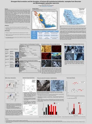
1. Divergent fluid evolution and the formation of fracture-fill hydrothermal dolomite: examples from Devonian
and Mississippian carbonate reservoirs
IHSAN AL-AASM AND CAROLE MRAD
University of Windsor, Windsor, Ontario, Canada N9B 3P4
E-mail: , alaasm@uwindsor.ca, mrad@uwindsor.ca
Abstract
Integrated petrographic, geochemical and fluid inclusion study of fracture filling mineralization, including
saddle dolomite cement extending from Alberta to British Columbia, Canada aims at quantifying the
type and nature of fluids that precipitated this dolomite and whether these fluids represent a single or
multiple events. Fracture-filling saddle dolomite from three Devonian and two Mississippian carbonate
successions were investigated in this study. The Devonian formations include Slave Point and
Duvernay formations and the Mississippian Upper Debolt and Turner Valley formations.
Paragenetically, saddle dolomite occluded fractures and vugs, predated by calcite cement but
postdated by anhydrite and sometimes quartz.
The δ18O isotopic values for the Devonian saddle dolomite (-14.6 to -5.58 ‰ VPDB; average -12.2 ‰)
combined with enriched 87Sr/86Sr isotopic ratios (0.708626 to 0.713480) and fluid inclusion data (125-
191.78oC; average 160 oC, 9.28 to 24.7 wt.% NaCl) show significant differences from the Mississippian
dolomite, which is characterized by less depleted δ18O isotopic values (-10.8 to -7.8 ‰ VPDB; average
-9.05 ‰), less radiogenic 87Sr/86Sr isotopic ratios (0.708591 to 0.709975) and lower homogenization
temperatures (Th) and salinity values of fluid inclusions (87-214.5 oC; average 130 oC , 2.0 to 13.2 wt.%
NaCl). These results suggest a possibly two different hydrothermal pulses related to early and late
tectonic events that affected the Western Canada Sedimentary Basin. δ18O isotopic values along with
87Sr/86Sr isotopic ratios and fluid inclusion data show somewhat spatial variability existed within the
Mississippian and Devonian fields whereby more depleted δ18O values, higher salinity and higher
temperature are observed in saddle dolomite from the Devonian carbonates in the NE part of the basin
compared to Mississippian dolostones in the NW part. This suggest the effect of compartmentalization
of hydrothermal fluids in the basin.
Objectives
Quantification of type and nature of fluids that precipitated fracture-filling saddle dolomite.
Determination of the relative timing and evolution of fracture mineralization as related to tectonic
history of the basin.
Methodology
Petrographic investigations including transmitted light and cathodoluminescence microscopy.
Stable (δ18O and δ13C) and strontium isotopic analysis of saddle dolomite and host dolostone in the
studied carbonate reservoirs.
Fluid inclusion analysis on saddle dolomites including homogenization temperature (Th) and salinity
(Tm) for primary fluid inclusions.
Geologic Setting
The studied fields included Sikanni and Quirk Creek from the Mississippian along with Hamburg,
Jedney and Duvernay from the Devonian.
Field Formation Age Location
Sikanni Upper Debolt Mississippian North East British Columbia
Hamburg Slave Point Middle Devonian North Western Alberta
Quirk Creek Turner Valley Upper Mississippian South Western Alberta
Jedney Slave Point Devonian North East British Columbia
-
Duvernay Upper Devonian Central Alberta
Map of WCSB showing the Devonian and Mississippian successions (modified from Richards 1989b)
Structural elements of the WCSB (modified from Geological Atlas of Western Canada Sedimentary Basin
1994)
A northwest-trending trough in front of the Cordilleran Fold and Thrust Belt termed the Alberta Basin and
the cratonic Williston Basin along with the eastern Canadian Cordillera constitute the Western Canada
Sedimentary Basin. The above sedimentary Basins are separated by the Bow Island Arch (Wright, 1984).
A major east-northeast trending basement structure called the Peace River Arch extended from the
Cordillera towards the craton across northeastern British Columbia and northwestern Alberta (Cant,
1988).The Peace River Arch in the Mississippian to Permian time became the site of a faulted basin
termed the Peace River Embayment. Prior to the Mississippian that Arch represented a topographic high
in Cambrian to late Devonian time.
Extensional tectonics produced the Liard Basin and the east-west oriented Peace River Embayment
during the late Devonian-Mississippian Antler Orogeny. During the late Mississippian (Pennsylvanian
period) a structural feature near the eastern part of the Peace River Embayment termed the Dunvegan
Fault was active. The Prophet Trough of Western Canada, which developed during the late Devonian to
early Carboniferous and persisted into late Cretaceous, contained the thickest Carboniferous sections
(Wright, 1984). Richards et al. (1994) suggested its extension from southeastern British Columbia to the
late Devonian and early Carboniferous Yukon Fold Belt as well as the Prophet Trough connection to the
Antler Foreland Basin (Western United States).
Paragenetic sequence of the Devonian Formations
Paragenetic sequence of the Mississippian Formations Petrographic Analysis of Devonian Saddle dolomite
Photomicrographs of Devonian saddle dolomite. (A-B) PPL and CL images
showing planar subhedral medium dolomite crystals followed by vug-filling
saddle dolomite and quartz infilling pore space, (C) CL image showing different
generations of pore filling saddle dolomite cement with multiple growth zones.
Under CL, SD displays oscillatory zonation of dull to bright red color with bright
red rims,(D) Anhydrite cement postdating saddle dolomite,(E) fracture filling
saddle dolomite cement crosscut by stylolite and postdating fine crystalline
matrix dolomite, (F) pore filling saddle dolomite cement postdating fine to
medium crystalline matrix anhedral to subhedral dolomite
Petrographic Analysis of Mississippian Saddle dolomite
Photomicrographs of Mississippian Saddle dolomite cement. (A) pore filling
calcite cement postdating anhydrite and pore filling saddle dolomite cement,
(B) pore filling saddle dolomite cement postdating planar subhedral to
euhedral medium grained dolomite, (C) saddle dolomite postdating fine
crystalline matrix dolomite, (D) saddle dolomite postdating early calcite
cement
Stable Isotope Geochemistry
-16 -14 -12 -10 -8 -6 -4 -2 2 4
-3
-2
-1
1
2
3
4
5
Mississippian Marine Dolomite
Middle Devonian Marine Dolomite
18
O vs.
13
C for saddle dolomite by Age
Mississippian
Devonian
13
C(VPDB)
18
O (VPDB)
-16 -14 -12 -10 -8 -6 -4 -2 2 4
-3
-2
-1
1
2
3
4
5
Mississippian Marine Dolomite
Middle Devonian Marine Dolomite
18
O vs.
13
C for saddle and matrix dolomite by Age
SD(Mississippian)
SD(Devonian)
MD(Mississippian)
MD (Devonian)
13
C(VPDB)
18
O (VPDB)
Saddle dolomite (SD) cement shows highly depleted values
indicating a burial environment with a hydrothermal fluid source
Devonian saddle dolomite (SD) δ18O isotopic values are more
depleted relative to the Mississippian SD indicating a different
pulse of hydrothermal fluid source
Devonian matrix dolomite(MD) δ18O isotopic values are more
depleted relative to the Mississippian MD suggesting
recrystallization during burial by a later (hydrothermal) fluids
Strontium Isotope Geochemistry
87Sr/86Sr isotopic ratios of the Devonian saddle
dolomite(SD), matrix dolomite (MD) and
pervasive dolomite (PD) are more enriched
relative to the Mississippian SD,MD and PD
indicating a more radiogenic source for Sr in
the Devonian system related to hydrothermal
fluids sourced from basement rocks
87Sr/86Sr isotopic ratios of the Devonian saddle
dolomite(SD) are significantly more radiogenic
than the postulated values for Middle Devonian
marine carbonates
87Sr/86Sr isotopic ratios of the Mississippian
saddle dolomite(SD) are more enriched than
the Middle Mississippian marine values
indicating precipitation from more radiogenic
fluid source.
Primary two-phase fluid inclusions in Saddle Dolomite
A
Fluid inclusions :( A) Fluid inclusion assemblage in saddle dolomite under 40x, (B): shows six two-phase
primary fluid inclusions (liquid rich with vapor bubble) in saddle dolomite ranging in shape from elongate to
sub circular and in size from 2 to 6 µm under 100x
Fluid Inclusion Results
B
Saddle dolomite fluid inclusion results from both age groups indicate precipitation in a burial environment
by a hot, slightly to highly saline fluid source related to hydrothermal activity
Saddle dolomites from the Devonian are characterized by a higher homogenization temperatures and
salinities relative to the Mississippian indicating two pulses of hydrothermal activity related to early and
late tectonic events
Highly saline values (20-25 wt. % NaCl eq.) of Saddle dolomite from the Devonian Slave Point Formation
(Hamburg) suggests its association with the Antlers Orogeny contrary to lower salinity values from the
Devonian Salve Point Formation (Jedney) that is related to hydrothermal fluid flow that occurred during
the Laramide Orogeny
Conclusions
Saddle dolomite formed in a shallow to intermediate burial depth from hydrothermal fluids
Isotopic and fluid inclusion data indicates a possible two different hydrothermal pulses related to early (Antler) and late (Laramide) tectonic events characterized saddle dolomite formation in the Western Canada Sedimentary Basin
Spatial variability existed within the Mississippian and Devonian fields whereby more depleted δ18O values, higher salinity and higher temperature are observed in saddle dolomite from the Devonian carbonates in the NE part of the basin compared to Mississippian saddle dolomite in the NW part as indicated by the isotopic
and fluid inclusion data
Calculated oxygen isotopic composition of the dolomitization fluid
for saddle dolomite (SD) and matrix dolomite (MD) (expressed in
VSMOW). Fractionation equation that is used is from Land (1983).
Matrix dolomite formed at lower temperatures compared to saddle
dolomite (SD), which is characterized by enriched δ18OSMOW values
forming at higher temperatures. A clear divergent fluid source is
demonstrated where the Devonian SD formed by a warmer brines
at higher temperature compared to the Mississippian SD.
& Hanson, 1990).
80 100 120 140 160 180 200 220
1
2
3
4
5
6
7
8
Frequency
Th
(°C)
Mississippian
Devonian
Histogram showing the frequency distribution of Th for fluid inclusions from saddle dolomite
5 10 15 20 25 30
1
2
3
4
5
6
7
8
9
10
Frequency
Salinity wt.%NaCl
Mississippian
Devonian
Histogram showing the frequency distribution of salinity for fluid inclusions from saddle dolomite.
80 90 100 110 120 130 140 150 160 170 180 190 200 210
2
4
6
8
10
12
14
16
18
20
22
24
26 Mississippian
Devonian
Salinitywt.%NaCl
TH
(°C)
Th vs. salinity of saddle dolomite by age.
-9 -5
-1
Mississippian
Dolomite
Dolomite types in the Devonian and Mississippian
Successions
SikanniJedney Hamburg
Quirk
Creek
Duvernay
E
50µm
SD
SD
50µm
F
A
50µm
B
50µm
C
50µm
D
50µm
50µm
B
SD
A
50µm
SD
50µm
C
SD
D
50µm
SD
Type of Dolomite Typical Petrographic
Characteristics
Fine Crystalline
Matrix Dolomite
(FCMD)
Size:4 to 15 µm
Shape: euhedral to
subhedral and anhedral
Dark red color under CL
Medium Crystalline
Matrix Dolomite
(MCMD)
Size: 20 to 150 µm
Shape: euhedral to
subhedral and anhedral
Dark red color under CL
Coarse Crystalline
Dolomite (CCD)
Size: from 200 to 500 µm
Shape: subhedral to
anhedral crystals
Dull red luminescent cores
and bright red rims under
CL
Pervasive Dolomite
(PD)
fabric destructive
Size:50 to 250 µm
Dull brownish red color with
bright red rims under CL
Saddle Dolomite
(SD)
Sweeping extinction and
curved crystal faces
Pore filling size :20 to 150
µm Fracture filling size: 50
to 500 µm
Oscillatory zonation of dull
to bright red colors with
dark red rims under CL
Diagenetic Process Early Late
Fine crystalline matrix dolomite
Silicification
Medium crystalline matrix
dolomite
Coarse crystalline dolomite
Early pore filling equant calcite
cement
Early fracture filling calcite cement
Mechanical compaction
Chemical Compaction
Pervasive dolomite
Pore filling saddle dolomite
Fracture filling saddle dolomite
Late fracture filling calcite cement
Late pore filling blocky calcite
cement
Anhydrite
Sikanni
Hamburg
Jedney
Duvernay
Quirk Creek
Diagenetic Process Early Late
Fine crystalline matrix dolomite
Medium crystalline matrix
dolomite
Early pore filling equant calcite
cement
Early fracture filling calcite cement
Mechanical compaction
Chemical Compaction
Pervasive dolomite
Pore filling saddle dolomite
Fracture filling saddle dolomite
Late pore and fracture filling
blocky calcite cement
Silicification
Anhydrite