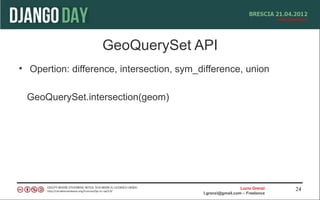
The document discusses using GeoDjango and HTML5 for geolocation applications. It begins with an introduction of the speaker and overview of topics to be covered, including HTML5 geolocation, GeoDjango, geographic information system (GIS) data formats, the GeoDjango API, and integrating GeoDjango with Google Maps and OpenStreetMaps. The document then covers specifics of each topic, such as HTML5 geolocation APIs, installing and configuring GeoDjango, spatial databases, GIS data problems and formats, the GeoDjango model, template, and view layers, GeoQuerySet APIs, and examples of integrating GeoDjango with Google Maps, OpenLayers, and recording geolocation data.


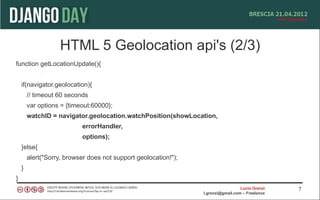
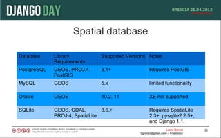

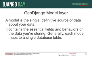

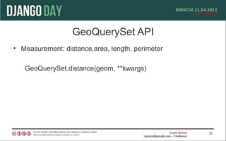

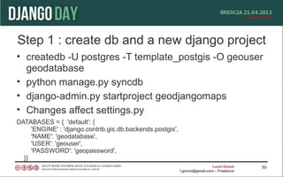
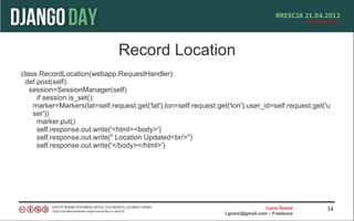
![Openlayer
<html>
<head>
<script src="http://openlayers.org/api/OpenLayers.js"></script>
<script> var points = []; </script>
<ul>
{% for point in interesting_points %}
<li>{{ point.name }} -- {{point.interestingness}}</li>
<script>points.push({{point.geometry.geojson|safe}});</script>
{% endfor %}
</ul> </scrpit>
</head>
<body onload="init()">
Intersting Points.<br />
<div id="map"></div>
</body></html>
Lucio Grenzi 36
l.grenzi@gmail.com – Freelance](https://image.slidesharecdn.com/geodjango-120426105812-phpapp01/85/Geodjango-36-320.jpg)
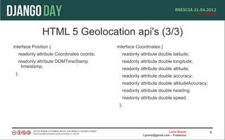
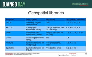
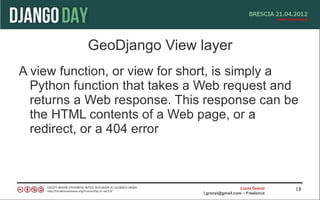
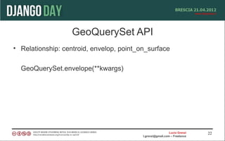
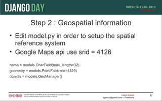
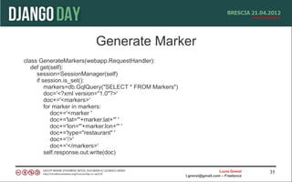
![Openlayer js script
<script type="text/javascript">
var map, base_layer, kml;
function init(){
map = new OpenLayers.Map('map');
base_layer = new OpenLayers.Layer.WMS( "OpenLayers WMS",
"http://labs.metacarta.com/wms/vmap0", {layers: 'basic'} );
var vectorLayer = new OpenLayers.Layer.Vector("Simple Geometry");
var point = new OpenLayers.Geometry.Point(-100.01, 55.78);
var pointFeature = new OpenLayers.Feature.Vector(point,null,null);
map.addLayer(vectorLayer);
map.setCenter(new OpenLayers.LonLat(point.x, point.y), 5);
vectorLayer.addFeatures([pointFeature]);
}
</script>
Lucio Grenzi 37
l.grenzi@gmail.com – Freelance](https://image.slidesharecdn.com/geodjango-120426105812-phpapp01/85/Geodjango-37-320.jpg)
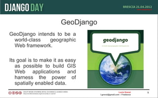
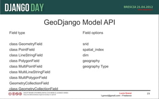
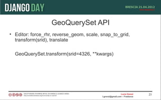
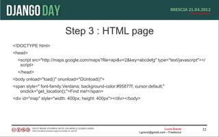
![Openlayer django script
vectors = OpenLayers.Layer.Vector("Simple Geometry");
for (var i = 0; i < points.length; i++) {
point = format.read(points[i])[0];
point.attributes = {'type':'point'};
vectors.addFeatures(point);
}
Lucio Grenzi 38
l.grenzi@gmail.com – Freelance](https://image.slidesharecdn.com/geodjango-120426105812-phpapp01/85/Geodjango-38-320.jpg)