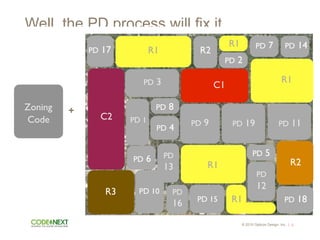
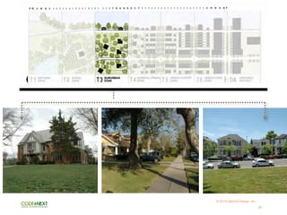
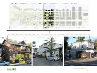
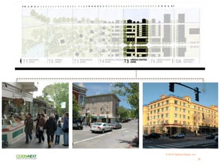
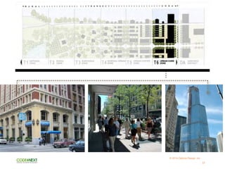
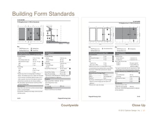
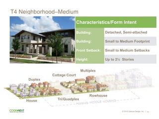
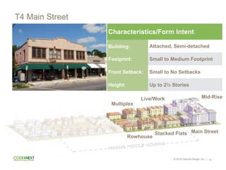
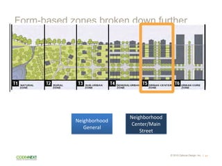
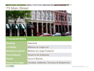
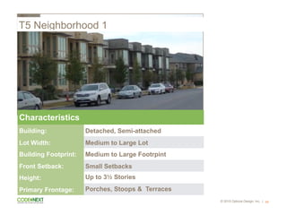
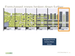
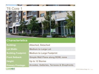
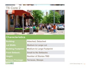
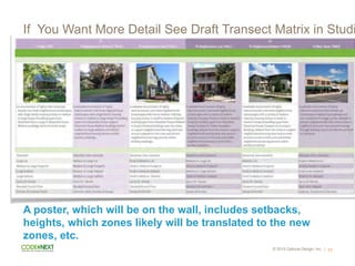
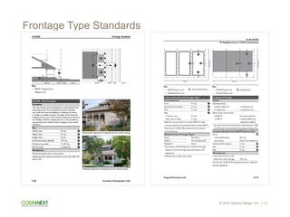
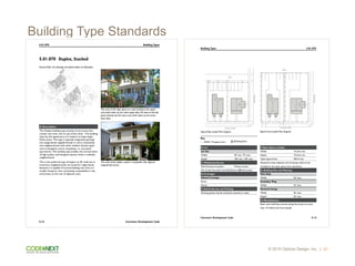
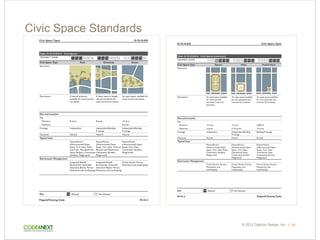
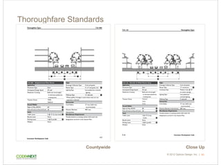
Form-Based Code 101
1
05.27.08
Building Placement
Build-to Line (Distance from Right of Way)
Bayfront Boulevard 0' A
Civic Space1
/ Secondary Street 0' B
Bayfront Promenade1
10' min.; 20' max.2
C
Side 0' D
BTL Defined by a Building
Bayfront Boulevard 100% min.
Secondary Street / Civic Space1
80% min.3
Bayfront Promenade1
80% min.
1
The Bayfront Promenade is treated as its own frontage distinct
from the Civic Space frontage within this zone.
2
The BTL for the first building to receive planning department
approval becomes the set BTL (must be within this range) for this
zone. All subsequent buildings must match the first building's BTL.
3
60% min. on Block J
Setback (Distance from Property Line or ROW)
Rear 0' min.
Lot Size
Width 100' min. E
Depth F
North of Bayfront Blvd. 100' min.
South of Bayfront Blvd. 50' min.
Building Form
Height
Building 2 Stories min.;
4 Stories max.
H
Ground Floor Finish Level 6" max. I
Ground Floor Ceiling 14' min. clear J
Upper Floor(s) Ceiling 8' min. clear K
Footprint
Depth, Ground-floor Commercial Space
Bayfront Boulevard 50' min.
Bayfront Promenade 30' min.
Secondary Street 30' min.
Miscellaneous
Distance between Entries
To Ground Floor 50' max.
All upper floors must have a primary entrance along Bayfront Blvd.
Service entries may not be located on Bayfront Boulevard.
Building Placement (Continued)
Miscellaneous
Buildings must be built to BTL along each facade within 30'
of a corner.
G
See the Streets and Circulation Regulation Plan on page 4-3 for
the determination of Primary and Secondary Streets.
T5-MS: Bayfront Boulevard Main Street Standards
Cont'd.
1-12 HWDMP Sub-District Amendments
Opticos Design, Inc.
Chapter 1: Building Form Standards
Sidewalk
Bayfront Boulevard
Bayfront Promenade / Rear
SecondaryStreet
CivicSpace
BTL, ROW Line
BTL,ROWLine
BTL,ROWLine
A
C
EF
D BB
I
ROW Line Street
K
K
K
J
H
G
G
G
G
G
G
G
G
ROW / Property Line
Build-to Line (BTL)
Setback Line
Building Area
Key
A Guide for Planners, Urban Designers,
Municipalities, and Developers
Form-Based Codes
Daniel G. Parolek, AIA Karen Parolek Paul C. Crawford, FAICP
Forewords by Elizabeth Plater-Zyberk and Stefanos Polyzoides
E
RO
UT
E
6
E BUTLE
R AVE
NBEAVERST
S
MIL
TO
N
RD
NLEROUXST
N
PI
NE
CL
IF
F
DR
NSANFRANCISCOST
W BIRCH AVE
N THORPE
RD
NBON
ITO
ST
W ASPEN AVE
N
SW
IT
ZE
R
CA
NY
ON
DR
W CHERRY AVE
S
BA
BB
ITT
DR
N
AZ
TE
C
ST
E
DA
VI
D
DR
KN
OL
ES
DR
N
TU
R
Q
U
O
IS
E
D
R
W
BE
AL
RD
NHUMPHREYSST
S
O'L
EA
RY
ST
S
SA
N
FR
AN
CIS
CO
ST
SBEAVER
ST
W ELM AVE
E CHERRY AVE
W CLAY AVE
E FRANKLIN AVE
NKENDRICKST
N
NAV
AJO
DR
W
RO
UT
E
66
SLONETREERD
NAGASSIZST
SLEROUXST
N
FO
RT
VA
LL
EY
RD
N
LO
CU
ST
ST
W
CO
CO
NI
NO
AV
E
W
KA
IB
A
B
LN
E
SAW
MIL
L
RD
W
FO
RE
ST
AVE
NPARKST
E BIRCH AVE
W SANTA FE AVE
E
PO
ND
ER
O
SA
PK
W
Y
W PHOENIX
AVE
W
LO
W
ER
C
O
C
O
N
IN
O
AV
E
NVERDEST
W RIOR
DAN
RD
W DALE AVE
N
BE
RT
RA
ND
ST
N
GE
M
IN
I
DR
NSITGREAVESST
N
RO
CK
RID
GE
RD
E ASPEN AVE
NMOGOLLONST
W BUTLER AVE
E ELM AVE
W
CH
AT
EA
U
DR
W NAVAJO RD
W DUPONT AVE
S
WIN
DS
OR
LN
W
OA
K
AVE
NELDENST
N
HO
PI
DR
NO
ELL
E
LN
W FINE AVE
E
BR
AN
NE
N
AVE
E DALE AVE
WMET
ZWAL
K
N
RIM
DR
W HUNT AVE
S
EL
LI
O
T
ST
W
MA
RS
HI
LL
RD
S
MI
KE
S
PI
KE
S
SP
RI
NG
ST
E COTTAGE AVE
NKINLAN
IRD
N
KIT
TR
ED
GE
RD
SAGASSIZST
E ELLERY AVE
W SULLIVAN AVE
N
FO
RE
ST
VIE
W
DR
S
VE
RD
E
ST
N
CU
RL
ING
SM
OK
E
DR
N
JA
ME
S
ST
W
GR
AN
D
CA
NY
ON
AV
E
W BENTON AVE
E
PAY
TO
N
WA
Y
E PHOENIX AVE
N
M
OR
IA
H
DR
W
PIU
TE
RD
S
FO
UN
TAI
NE
ST
N
W
IL
LI
AM
RD
W TUCSON
AVE
W APACHE RD
SPARKST
E DUPONT AVE
W TOMBSTO
NE AVE
S
RIV
ER
RU
N
RD
W
HA
VAS
UP
AI
RD
W
SU
M
M
IT
AV
E
W COTTAGE
AVE
E FINE AVE
E
JAC
KS
ON
DR
N
EN
TE
RP
RI
SE
E
JON
NY
LP
S
CA
MB
RID
GE
LN
DESILVA AVE
S
ELD
EN
ST
SHUMPHREYSST
NTOLTECST
W TOLC
HACO
RD
OSBORNEDR
S
BL
AC
KB
IRD
RO
OS
T
S
MA
LPA
IS
LN
E
HIL
LTO
P
AV
E
S
SY
CA
M
OR
E
ST
E
TE
RR
AC
E
AV
E
S
ER
NE
ST
ST
SFLOREN
CEST
E
KEN
SIN
GT
ON
DR
E BENTON AVE
E APPL
E WAY
PA
YT
ON
WA
Y
W ELLERY AVE
E
FO
RE
ST
AVE
E HUTCHESON DR
N
MC
MIL
LA
N
RD
S
W
AL
NU
T
ST
PIN
ON
CT
SPAS
EO
DEL
FLA
G
W
WH
IPP
LE
RD
NAPOLLOWAY
E
PA
SE
O
DE
L
RI
O
TORMEY AVE
E
PIC
CA
DIL
LY
DR
MO
UN
TAI
N
VIE
W
DR
E
CR
ES
TV
IEW
DR
S
W
IL
SO
N
LN
W
WH
ITIN
G
RD
SKINGMAN
ST
E
WO
OD
LAN
D
DR
S
BR
AN
NE
N
CIR
N
HE
ML
OC
K
WA
Y
W COLUMBUS AVE
S
SE
VIL
LE
LN
N
CH
AR
LE
S
RD
N
MA
NZ
AN
ITA
WA
Y
S
CA
LL
E
RE
PO
SA
N
CLA
RK
CIR
E
AS
HU
RS
T
AV
E
MC
CR
EA
RY
E
SH
ER
W
OO
D
LN
N
EV
ER
GR
EE
N
DR
SW
ITZ
ER
DR
SMAR
ICO
PA
ST
N
OTT
O
DR
W
HOG
AN
DR
N
GE
OR
GE
ST
N
CA
NY
ON
TE
RR
AC
E
DR
S
RE
GE
NT
ST
S
GA
BE
LST
W
MO
NT
VA
LE
AV
E
S
BU
CK
ING
HA
M
LN
N
CIR
CL
E
DR
N
LOM
ALA
ILN
E HUNT AVE
E CAL
LE
CON
TEN
TA
S
PI
N
N
AC
LE
ST
MCMULLENCIR
E
OL
IV
IN
E
W
AY
SGLOBE
ST
N
CO
NIF
ER
RD
NHILLSIDEST
E
CA
NY
O
N
VI
EW
DR
N
CI
RC
LE
VI
EW
DR
HO
SK
INS
AVE
S
NO
ELL
E
LN
SKENDRICKST
W MCMULLEN CIR
SLUMBERST
S
CO
LO
RA
DO
ST
E CHU
RCH
ILL
DR
E
BAR
RO
W
AVE
E
TUR
NE
Y
DR
NCLE
AR
VIEW
DR
N
SU
NS
ET
DR
W
AN
DE
RS
ON
RD
G
R
EE
N
BR
IA
R
LN
E COLUMBUS AVE
S
TR
AIL
OF
TH
E
WO
OD
S
E
ST
O
N
E
R
ID
G
E
D
R
W
CE
DA
R
AVE
E
HAT
CH
ER
DR
W
LAV
A
LN
E TRE
VOR
WAY
EIVY
LN
BLO
ME
DR
NKUT
CH
DR
N
MA
GM
A
W
AY
N
HIL
LTO
P
DR
W
BAS
ALT
LN
EOLD
CAN
YON
CT
E
JA
CO
B
W
AY
W
DE
AN
NA
DR
E
RU
SS
WA
Y
S
CA
RR
IAG
E
LN
E
MC
CR
AC
KE
N
ST
E
HE
LEN
WA
Y
E
CH
UB
S
WA
Y
E
MA
KAY
LA
WA
Y
SLON
ETRE
ERD
S
BEA
VER
ST
NAZTECST
WROUTE66
T2
T1
T3
T4
T5
T6
Civic
E ROU
TE
E BUTLE
R AVE
N
BEA
VER
ST
INT
ER
STA
TE
40
S
MI
LT
ON
RD
N
LER
OUX
ST
N
PIN
E
CL
IFF
DR
N
SAN
FRA
NCI
SCO
ST
W
BIRC
H
AVE
N THOR
PE
RD
NBONITO
ST
W
ASP
EN
AVE
N
SW
ITZ
ER
CA
NY
ON
DR
W
CHE
RRY
AVE
SBABBITTDR
E
DA
VI
D
DR
KNOLESDR
N
TUR
QUO
ISE
DR
N
HUM
PHR
EYS
ST
SO'LEARYST
SSANFRANCISCOST
SBEAV
ER
ST
W
ELM
AVE
E
CHE
RRY
AVE
W
CLA
Y
AVE
E
FRA
NKL
IN
AVE
N
KEN
DRIC
K
ST
W
RO
UT
E
66
S
LON
E
TRE
E
RD
N
AGA
SSIZ
ST
S
LER
OUX
ST
NLOCUSTST
W COCO
NINO
AVE
W
KAIB
AB
LN
E SAWMILL RD
N
PAR
K
ST
E
BIRC
H
AVE
W
SAN
TA
FE
AVE
E
PO
ND
ER
OS
A
PKW
Y
W PHOE
NIX
AVE
W
LOW
ER
COC
ONI
NO
AVE
N
VER
DE
ST
W
RIO
RD
AN
RD
W
DAL
E
AVE
NBERT
RAND
ST
N GEMI
NI
DR
N
SITG
REA
VES
ST
E
ASP
EN
AVE
N
MOG
OLL
ON
ST
W
BUT
LER
AVE
E
ELM
AVE
W
CHA
TEA
U
DR
W
NAV
AJO
RD
W
DUP
ONT
AVE
SWINDSORLN
N
ELD
EN
ST
NO
EL
LE
LN
W
FINE
AVE
E BRANNEN AVE
E
DAL
E
AVE
W
ME
TZ
WA
LK
W
HUN
T AVE
S
ELL
IOT
ST
WMARS
HILL
RD
S
MIK
ES
PIK
E
SSPRIN
GST
E
COT
TAG
E
AVE
NKINLA
NIRD
S
AGA
SSIZ
ST
E
ELLE
RY
AVE
W
SUL
LIVA
N
AVE
N
FO
RE
ST
VI
EW
DR
SVERDEST
N
JA
ME
S
ST
W GRAN
D CANY
ON
AVE
W
BEN
TON
AVE
E
PA
YT
ON
WA
Y
E
PHO
ENIX
AVE
N
MO
RIA
H
DR
SFOUNTAINEST
N
WI
LL
IAM
RD
W TUCS
ON
AVE
W
APA
CHE
RD
SPARK
ST
E
DUP
ONT
AVE
W TOMB
STON
E AVE
SRIVERRUNRD
W SUMM
IT AVE
W COTT
AGE
AVE
E
FINE
AVE
E JACKSON DR
NENTE
RPRIS
ERD
E
JO
NN
Y
LP
SCAMBRIDGELN
DES
ILVA
AVE
SELDENST
S
HUM
PHR
EYS
ST
N
TOL
TEC
ST
OSB
ORN
E
DR
SBLACKBIRDROOST
SMALPAISLN
E HILLTOP AVE
SSYCA
MORE
ST
E
TER
RA
CE
AVE
SERNESTST
SFLOR
ENCE
ST
E KENSINGTON DR
E
BEN
TON
AVE
E APPLE
WAY
PA
YT
ON
WA
Y
W
ELL
ERY
AVE
E
HUT
CHE
SON
DR
SWALN
UT
ST
PINON CT
S
PA
SE
O
DE
L
FL
AG
N
APO
LLO
WAY
E PASEO
DEL RIO
TOR
MEY
AVE
E PICCADILLY DR
MOUNTAIN VIEW DR
E CRESTVIEW DR
SWILS
ON
LN
SKINGM
AN
ST
E WOODLAND DR
S
BR
AN
NE
N
CI
R
NHEMLOCKWAY
W
COL
UMB
US
AVE
SSEVILLELN
N CHAR
LES
RD
NMANZANITAWAY
S
CA
LL
E
RE
PO
SA
E ASHURST AVE
MCCREARY
E
SH
ER
WO
OD
LN
SWITZER DR
SMARICOPAST
NOTTODR
NGEORGEST
NCANYO
NTERRA
CEDR
SREGENTST
SGABELST
W MONT
VALE
AVE
SBUCKINGHAMLN
N
CI
RC
LE
DR
E
HUN
T AVE
E
CA
LL
E
CO
NT
EN
TA
S
PIN
NAC
LE
ST
MCM
ULL
EN
CIR
E
OL
IVI
NE
WA
Y
SGLOB
EST
N
HILL
SIDE
ST
E
CA
NY
ON
VIE
W
DR
N
CIR
CL
E
VIE
W
DR
HOSKINS AVE
S
NO
EL
LE
LN
S
KEN
DRIC
K
ST
W
MCM
ULL
EN
CIR
S
LUM
BER
ST
SCOLORADOST
E CHURCHILL DR
E BARROW AVE
E
TU
RN
EY
DR
NCLEARVIEWDR
GR
EEN
BRI
AR
LN
E
COL
UMB
US
AVE
STRAILOFTHEWOODS
E
STO
NE
RIDG
E
DR
E
HA
TC
HE
R
DR
E
TR
EV
OR
WA
Y
E
IVY
LN
BLOME DR
N
MA
GM
A
WA
Y
NHILLTOPDRE
OL
D
CA
NY
ON
CT
E
JAC
OB
WA
Y
E
RU
SS
WA
Y
SCARRIAGELN
E MCCRACKEN ST
E
HE
LE
N
WA
Y
E
CH
UB
S
WA
Y
E
MA
KA
YL
A
WA
Y
SLONETREERD
SBEAVERST
N
AZT
EC
ST
W
ROU
TE
66
0 200' 400'
1 Acre¼ Acre
Regulating Plan
Flagstaff, Arizona
October 9, 2009
© C o p y r i g h t 2 0 0 8
Opticos Design, Inc.
1285 Gilman Street
Berkeley, CA 94706
510 - 558 - 6957
0 200' 400'
Sound Check
Dan Parolek

Principal, Opticos Design, Inc.

Brown Bag Lunch

November 17, 2015
© 2015 Opticos Design, Inc. |
Euclidean Zoning is an Out-of-Date Operating
2
© 2015 Opticos Design, Inc.
Conventional Zoning Summarized
95. Physical culture institution
109. Potato chip manufacturing
127. Tombstones, retail sales
135. Turkish bath
19. Baths,Turkish
25. Boxing arena
28. Chinchillas, retail sales
41. Eleemosynary institutions
42. Embalming business
• Emphasis on regulation by use
• Disconnect between land use, urban form, and design
• Exceptions become the rule
3
© 2015 Opticos Design, Inc. |
Well, more process will fix it
Zoning
Code
4
Then
© 2015 Opticos Design, Inc. | 5
Well, the PD process will fix it
PD 4 PD 19
PD 3
PD 8
PD 1 PD 9
PD
12
PD 7
C1
PD 6
PD 10
PD 2
R1
R1
R2
R2
C2
R3
R1
PD 11
PD
13
PD 5
PD 14
R1
PD 15
PD
16
PD 17
PD 18R1
Zoning
Code
+
Different zoning tools for difference types of
places
The New Operating System
6
What’s in common?
© 2015 Opticos Design, Inc. |
3 at 3 stories and 1 at 12 stories
2 story building on 2/3 of site
© 2015 Opticos Design, Inc. |
Conventional zoning says they’re the same
0.60 FAR 0.60 FAR
© 2015 Opticos Design, Inc. |
The 21st Century Operating System is Form
Form-Based
Approach
Lower parking requirements 

(More walking, access to transit)
Public realm = Public space
Blended density (variety of types)
Mixed use environments
Conventional 

Use-Based Approach
Higher parking requirements 

(Less walking and access to transit)
“Podded” densities and uses
Larger public and private open space
required due to isolation
Uses more flexible based on
operational characteristics
Specific Uses allowed
Walkable Urban Places Drivable Suburban Places
© 2015 Opticos Design, Inc. | 10y Multi-Jurisdictional Form-Based Code
Design, Inc.
July 19th, 2010
Up LandsLow Lands
RuralUrban
Rural Crossroads
Hamlet
Village
City
Town
Different Neighborhoods Require Different Solutions
Beaufort County, South Carolina Multi-Jurisdictional Code: Place Types
© 2015 Opticos Design, Inc. |
© 2013 Opticos Design, Inc. | 11
Different Types of Places in Austin
SuburbanTransitionalWalkable Urban
© 2015 Opticos Design, Inc. |
Conventional/Euclidean Zoning: Suburban Places
12
© 2015 Opticos Design, Inc. |
Form-Based Coding: Existing Walkable Urban
13
© 2015 Opticos Design, Inc. |
Hybrid Code is Selected Approach
• •
How one city overhauled its zoning code
while combiningform-based and conventional elements.
By Roger E. Eastman, AICP, with Daniel Parolek and Lisa Wise
LAGSTAFF, ARIZONA, entered an exclusive club in
November. It is now one of the few cities in the U.S.
that have adopted a hybrid zoning ordinance with
both fom1-based components and conventional Eu-
clidean elements as part of a complete code rewrite.
"Simplified, streamlined, predictable" raved an edito-
rial in the Arizona Daily Sun while praising both the
code and the process used to adopt it. Getting the
new code adopted wasn't easy, but many city residents
think the effort will be repaid in a more efficient, more equitable, and
easier-to-use zoning system. The adoption of the new zoning code
also caps offa successful public engagement process that has changed
the generally negative perception ofcity plaImers.
TIME FOR AN UPDATE
An im.portant first step in approaching a
new code W,1S differentiating between what
Clu'istopher Leinberger caBs "walkable ur-
ban" areas from "drivable suburb,m" areas
(Tbe Option ofUrbrl7Zism, Island Press, 2008).
By making this distinction, Flagstaff could
apply a form-based code in the walkable
areas of the city wIllie generaBy leaving the
existing conventional code in place in the
drivable suburban areas.
Thus, a new u'ansect-based hybrid code
resulted that defaults to promoting and al-
lowing for walkable urbanism wIllie seam-
lessly incorporating refined yet otherwise
conventional Euclidean zoning tools for the
drivable suburban areas. Because the regula-
tions for the two different types of areas are
not muddled together, the form-based code
could be kept intact-and development op-
poruU1ities could emerge in a manner con-
sistent with the city's general plan.
Flagstaff (pop. 62,000), at an elevation
of about 7,000 feet, is the regional hub of
northern Arizona. Established as a stop on
the early u'anscontinental railway in 1882
and later Route 66 and Interstate 40, Flag-
staff quickly grew as a logging and ranching
town, and as a gateway for tourists visiting
the Grand Canyon and other national parks
and monuments. Residents appreciate the
natural beauty ofthe area and enjoy outdoor
pursuits such as hiking, skiing, hunting, fish-
ing, and camping.
T he downtown and oldest neighbor-
hoods were plmmed with sm,111 blocks and
lots, and today are valued for their historic
buildings and inherently walkable urban
character. Typical of many American cities,
Flagstaffs urban form changed after vVorld
vVar IT as auto-oriented suburban develop-
ments were' added to tile periphelY of tile
city. Until recently Flagstaffs zoning ordi-
nances have actively promoted tllese drive-
able suburbml development patterns.
The need for a comprehensive update of
tile city's land development code had been
apparent for some time as developers, con-
u'actors, desigll professionals, and residents
complained about tile code's complexity and
inconsistency. Some even blamed tile CLllll-
bersome namre of tile code for conu'ibuting
to the high cost ofdevelopment and tile fail-
ure of big projects and economic develop-
ment opporuU1ities.
American Planning Association 25
© 2015 Opticos Design, Inc. |© 2012 Opticos Design, Inc. |
Form-Based Code Definition
15
"Form-based codes foster predictable built results and a high-
quality public realm by using physical form (rather than
separation of uses) as the organizing principle for the code.
They are regulations, not mere guidelines. They are adopted
into city or county law. Form-based codes are an alternative to
conventional zoning."
Form-Based Code Institute
Place-based operating system
The Rural to Urban Transect as the
New Operating System
16
Historic Humboldt-Chimborazo

This first transect was conceived by
Alexander Von Humboldt in 1793. It is taken
across the southern tip of South America,
from the Atlantic to the Pacific and is
vertically exaggerated. This curious
document has notations on the surface of
the earth, beneath the surface, and also,
apparently, the atmospheric conditions.
1790’s
17
© 2014 Opticos Design, Inc.
18
Geddes’ Valley Section 

A century after the Humboldt transect, the
Scotsman Patrick Geddes drew the “valley
section,” taken from ridgeline to shoreline.
It is the first transect to show natural
conditions with their associated human
presence, presented only in terms of
exploitation—a 19th century conception.
1909
© 2014 Opticos Design, Inc.
© 2015 Opticos Design, Inc. |
Transect Concept’s Initial Use in the Natural Environment
19
1969
Ian McHarg, Design with Nature

The famous landscape architect documented the
variety of distinct environments and their individual
components and species that needed those
environments to thrive.
20
2000
© 2014 Opticos Design, Inc.
© 2015 Opticos Design, Inc. |
In 2000 It Was Adapted to the Built Environment
21
T1 T6 SDT5T4T3T2
22
© 2014 Opticos Design, Inc.
23
© 2014 Opticos Design, Inc.
24
© 2014 Opticos Design, Inc.
25
© 2014 Opticos Design, Inc.
26
© 2014 Opticos Design, Inc.
27
© 2014 Opticos Design, Inc.
28
© 2014 Opticos Design, Inc.
Salt Lake City 2014 Conventional Zoning vs Form-Based Zoning © 2015 Opticos Design, Inc. |
New York, NY T2, T4 – T6
4
Environments
Salt Lake City 2014 Conventional Zoning vs Form-Based Zoning © 2015 Opticos Design, Inc. |
3
Environments
Downtown Salt Lake T4 – T6
Salt Lake City 2014 Conventional Zoning vs Form-Based Zoning © 2015 Opticos Design, Inc. |
4
Environments
Salt Lake DT Neighborhoods T2 – T5
Salt Lake City 2014 Conventional Zoning vs Form-Based Zoning © 2015 Opticos Design, Inc. |
5
Environments
Park City T1 – T5
l. TRANSECT ZONES
© 2015 Opticos Design, Inc. |
Base Zones Based on a Hierarchy of Form Primarily
33
© 2014 Opticos Design, Inc. |© 2015 Opticos Design, Inc. |
Hierarchy of Form & Scale Should be Clear in Base
34
Less Urban
T5 Neighborhood 2 (T5N.2)T3 Neighborhood (T3N)
T3 Estate (T3E)
T4 Neighborhood 2 (T4N.2)
T4 Neighborhood 1 (T4N.1) T5 Neighborhood 1 (T5N.1)
T3 T4 T5
More Urban
From Cincinnati, Ohio
© 2014 Opticos Design, Inc. |© 2015 Opticos Design, Inc. |
Hierarchy of Form & Scale Should be Clear in Base
35
Less Urban
T5 Flex (T5F)
T5 Main Street (T5MS) T6 Core (T6C)
T6T5 (continued)
More Urban
From Cincinnati, Ohio
The initial calibratin to Austin
How is the Transect Being Applied in
Austin?
36
© 2012 Opticos Design, Inc. |
Close UpCountywide
10-40.40.080
10-75Flagstaff Zoning Code
T4 Neighborhood 2 (T4N.2) Standards
ROW/Property Line
Building Setback Line
Encroachment Area
Key
ROW/Property Line
Parking Setback Line
Parking Area
Key
G. Required Parking
Spaces7
Residential Uses
Studio/1 Bedroom 1 space/unit min.
2+ Bedrooms 2 spaces/unit min.
Retail Trade, Service Uses
≤2,000 sf No spaces required
>2,000 sf 2 spaces/1,000 sf min.
above first 2,000 sf
7
Use types not listed shall meet the requirements in Table
10-50.70.040.A (Automobile Parking Spaces Required).
Location (Setback from ROW/Property Line)
Front
Covered/Attached 30' min.
Uncovered Match front facade min.
Side Street/Civic Space 5' min.
Side 0' min.
Rear 0' min.
Miscellaneous
Linear feet of front or side
façade that may be garage 35% max.
See Division 10-50.70 (Parking Standards) for additional
parking regulations.
M
N
O
P
F. Encroachments and Frontage Types
Encroachments4
Front 5' max.
Side Street/Civic Space 5' max.
Side 3' max.
Rear
Property Line 0' max.
Rear Lane or Alley 3' max.
Galleries may encroach in to street ROW, all other
encroachments are not allowed within a street ROW.
4
See Section 10-50.35 (Encroachments) for allowed
encroachments.
Allowed Private Frontage Types5
Stoop Forecourt
Gallery6
Terrace/Lightwell6
Shopfront6
Porch
5
See Division 10-50.30 (Specific to Private Frontage
Types) for private frontage type descriptions and
regulations.
6
Allowed only in open sub-zone(s).
I
J
K
L
Street
I
J
SideStreet
N
P
O
SideStreet
Street
M
K
L
10-40.40.080
10-74 Flagstaff Zoning Code
T4 Neighborhood 2 (T4N.2) Standards
D. Building Placement
Setback (Distance from ROW/Property Line)
Principal Building
Front1
5' min.; 12' max.
Front facade within area 50% min.
Side Street/Civic Space 10' min.; 15' max.
Side2
3' min.
Rear 3' min.
Outbuilding
Front 20' min.
Side 0' min.; 3' max.
Rear 3' min.
1
Setback may match an existing adjacent building as
follows. The building may be set to align with the facade
of the frontmost immediately adjacent property, for a
width no greater than that of the adjacent property's
facade that encroaches into the minimum setback.
2
No side setback required between townhouse and/or
live/work building types.
Miscellaneous
Upper-floor units must have a primary entrance along a
street or courtyard façade.
Ground-floor residential units along a street must have
individual entries.
A
B
C
D
E. Building Form3
Height
Principal Building
Stories 4 Stories max.
To Eave/Parapet 40' max.
Overall 52' max.
Outbuilding 2 Stories max.
To Eave/Parapet 18' max.
Overall 28' max.
Ground Floor Finish Level 18" min. above
sidewalk
Ground Floor Ceiling 9' min. clear
Upper Floor(s) Ceiling 8' min. clear
3
See Division 10-50.100 (Specific to Building Types) for
additional building form regulations.
Footprint
Depth, ground-floor residential
space along primary street
frontage
30' min.
Lot Coverage 80% max.
Miscellaneous
Mansard roof forms are not allowed.
E
F
G
H
ROW Line Street
ROW/Property Line
Building Setback Line
Building Area
Facade Area
Key
Street
D
SideStreet
H
GA
min.
A
max.
B
min.
B
max.
C
F
E
Building Form Standards
37
l. TRANSECT ZONES
© 2015 Opticos Design, Inc. |
Form-based Zones being considered for Austin
l. TRANSECT ZONES
© 2015 Opticos Design, Inc. |
Form-based zones broken down further
39
Neighborhood	
  
General
Neighborhood	
  
Edge
© 2015 Opticos Design, Inc. |
T3 Neighborhood–Edge
40
Characteristics/Form Intent
Building: Detached, Semi-attached
Footprint: Medium to Large Footprint
Front Setback: Medium to Large Setback
Height: Up to 2½ Stories
House
© 2015 Opticos Design, Inc. |
T3 Neighborhood–Medium
41
Characteristics/Form Intent
Building: Detached, Semi-attached
Building Footprint: Medium to Large Footprint
Front Setback: Medium to Large Setback
Height: Up to 2½ Stories
Building Types Carriage House; House; Cottage
Court
Cottage Court
House
Has T3 Edge been purposefully
excluded?
Building types list only the Type family,
not the size variations in order to save
space in the table. (Ex: “House” rather
than “House: Compact, Small,
Medium”)
© 2015 Opticos Design, Inc. |
T3 Neighborhood–High
42
Characteristics/Form Intent
Building: Detached, Semi-attached
Footprint: Small to Medium Footprint
Front Setback: Small to Medium Setback
Height: Up to 2½ Stories
House
Cottage Court
Duplex
l. TRANSECT ZONES
© 2015 Opticos Design, Inc. |
Form-based zones broken down further
43
Neighborhood	
  
General
Neighborhood	
  
Center/Main	
  
Street
© 2015 Opticos Design, Inc. | 44
Characteristics/Form Intent
Building: Detached, Semi-attached
Footprint: Small to Medium Footprint
Front Setback: Medium to Large Setback
Height: Up to 2½ Stories
House
Cottage Court
Duplex
Tri/Fourplex
T4 Neighborhood–Low
© 2015 Opticos Design, Inc. |
T4 Neighborhood–Medium
45
Characteristics/Form Intent
Building: Detached, Semi-attached
Building: Small to Medium Footprint
Front Setback: Small to Medium Setbacks
Height: Up to 2½ Stories
House
Cottage Court
Duplex
Tri/Quadplex
Rowhouse
Multiplex
© 2015 Opticos Design, Inc. |
T4 Main Street
46
Characteristics/Form Intent
Building: Attached, Semi-detached
Footprint: Small to Medium Footprint
Front Setback: Small to No Setbacks
Height: Up to 2½ Stories
Mid-Rise
Rowhouse
Live/Work
Main Street
Multiplex
Stacked Flats
l. TRANSECT ZONES
© 2015 Opticos Design, Inc. |
Form-based zones broken down further
47
Neighborhood	
  
General
Neighborhood	
  
Center/Main	
  
Street
© 2015 Opticos Design, Inc. |
T5 Main Street
48
Characteristics
Building: Attached
Lot Width: Medium to Large Lot
Building Footprint: Medum to Large Footprint
Front Setback: Small to No Setbacks
Height: Up to 5 Stories
Primary Frontage: Arcades, Galleries, Terraces & Shopfronts
© 2015 Opticos Design, Inc. |
T5 Neighborhood 1
49
Characteristics
Building: Detached, Semi-attached
Lot Width: Medium to Large Lot
Building Footprint: Medium to Large Footrpint
Front Setback: Small Setbacks
Height: Up to 3½ Stories
Primary Frontage: Porches, Stoops & Terraces
l. TRANSECT ZONES
© 2015 Opticos Design, Inc. |
Form-based zones broken down further
50
Neighborhood	
  
Center/Main	
  
Street
© 2015 Opticos Design, Inc. |
T6 Core 1
51
Characteristics
Building: Attached, Detached
Lot Width: Medium to Large Lot
Building Footprint: Medium to Large Footprint
Front Setback: Simple Wall Plane along ROW, none
Height: Up to 12 Stories
Primary Frontage: Arcades, Galleries, Terraces & Shopfronts
© 2015 Opticos Design, Inc. |
T6 Core 2
52
Characteristics
Building: Attached, Detached
Lot Width: Medium to Large Lot
Building Footprint: Medium to Large Footprint
Front Setback: Small to No Setbacks
Height: Number of Stories TBD
Primary Frontage: Terraces, Stoops
© 2015 Opticos Design, Inc. |
If You Want More Detail See Draft Transect Matrix in Studi
53
A poster, which will be on the wall, includes setbacks,
heights, which zones likely will be translated to the new
zones, etc.
Not just new base zone districts-An entire system
Other Components 

of a Form-Based Code
54
© 2015 Opticos Design, Inc. |
10-40.40.080
10-75Flagstaff Zoning Code
T4 Neighborhood 2 (T4N.2) Standards
ROW/Property Line
Building Setback Line
Encroachment Area
Key
ROW/Property Line
Parking Setback Line
Parking Area
Key
G. Required Parking
Spaces7
Residential Uses
Studio/1 Bedroom 1 space/unit min.
2+ Bedrooms 2 spaces/unit min.
Retail Trade, Service Uses
≤2,000 sf No spaces required
>2,000 sf 2 spaces/1,000 sf min.
above first 2,000 sf
7
Use types not listed shall meet the requirements in Table
10-50.70.040.A (Automobile Parking Spaces Required).
Location (Setback from ROW/Property Line)
Front
Covered/Attached 30' min.
Uncovered Match front facade min.
Side Street/Civic Space 5' min.
Side 0' min.
Rear 0' min.
Miscellaneous
Linear feet of front or side
façade that may be garage 35% max.
See Division 10-50.70 (Parking Standards) for additional
parking regulations.
M
N
O
P
F. Encroachments and Frontage Types
Encroachments4
Front 5' max.
Side Street/Civic Space 5' max.
Side 3' max.
Rear
Property Line 0' max.
Rear Lane or Alley 3' max.
Galleries may encroach in to street ROW, all other
encroachments are not allowed within a street ROW.
4
See Section 10-50.35 (Encroachments) for allowed
encroachments.
Allowed Private Frontage Types5
Stoop Forecourt
Gallery6
Terrace/Lightwell6
Shopfront6
Porch
5
See Division 10-50.30 (Specific to Private Frontage
Types) for private frontage type descriptions and
regulations.
6
Allowed only in open sub-zone(s).
I
J
K
L
Street
I
J
SideStreet
N
P
O
SideStreet
Street
M
K
L
4.03.050 Frontage Standards
4-30 Livermore Development Code
4.03.050 Porch: Integral
Description
The main facade of the building has a small setback from
the property line.The resulting front yard is typically
very small and may be undefined or defined by a fence
or hedge to spatially maintain the edge of the street.An
integral porch is part of the overall massing and roof form
of a building. With an integral porch it is not possible to
remove the porch without major changes to the overall
roof form.
Size
Width, clear 8' min.
Depth, clear 8' min.
Height, clear 8' min.
Finish level above sidewalk 18" min.
Furniture area, clear 4' x 8' min.
Path of travel 3' wide min.
Miscellaneous
The porch may be one or two stories.
Integral porches may be enclosed on up to two sides and
have a roof.
A
B
C
D
E
F
ROW / Property Line
Setback Line
Key
Setback ROW Walk Street Setback ROW Walk Street
Partial-length integral porch integrated into the overall massing.
Full-length integral porch integrated into the overall massing.
E
E
D
B
A
C
F
Frontage Type Standards
55
© 2015 Opticos Design, Inc. |
This Transition is Very Important to Regulate!
56
© 2015 Opticos Design, Inc. |
5.01.070Building Types
5-13Livermore Development Code
B. Lot
Lot Size
Width 50' min., 75' max.
Depth 100' min., 150' max.
C. Pedestrian Access
Main Entrance Location Primary street
On corner lots each unit shall front a different street.
D. Frontages
Allowed Frontages
Porch
Stoop
E.Vehicle Access and Parking
Parking spaces may be enclosed, covered, or open.
F. Open Space, Usable
Width 15'/unit min.
Depth 15'/unit min.
Open Space Area 300 sf min.
Required street setbacks and driveways shall not be
included in the open space area calculation.
G. Building Size and Massing
Main Body
Width 36' max.
Secondary Wing
Width 24' max.
Detached Garage
Width 36' max.
Depth 25' max.
H. Miscellaneous
Both units shall have entries facing the street no more
than 10' behind, the front façade.
Primary Street
Alley
SideStreet
Primary Street
Rear
SideStreet
ROW / Property Line Building Area
Key
Typical Alley Loaded Plan Diagram Typical Front Loaded Plan Diagram
5.01.070 Building Types
5-12 Livermore Development Code
The entry to the right opens to a stair leading to the upper
unit, which takes up the entire upper floor.The door to the left
opens directly into the lower unit, which takes up the entire
lower floor.
The scale of this duplex makes it compatible with adjacent
single-family homes.
5.01.070 Duplex, Stacked
General Note: the drawings and photos below are illustrative.
A. Description
This Duplex building type consists of structures that
contain two units, one on top of the other. This building
type has the appearance of a medium to large single-
family home. This type is typically integrated sparingly
into single-family neighborhoods or more consistently
into neighborhoods with other medium-density types
such as bungalow courts, fourplexes, or courtyard
apartments. This building type enables the incorporation
of high-quality, well-designed density within a walkable
neighborhood.
This is the preferred type of duplex on 50' wide lots in
Livermore neighborhoods not zoned for single-family
because it is capable of accommodating two units in a
smaller footprint, thus maximizing compatibility in size
and privacy to the rear of adjacent units.
Building Type Standards
57
© 2014 Opticos Design, Inc. |
Kit of Parts for Neighborhoods: Cincinnati, Ohio
58
Cincinnati Citywide Form-Based Code
© 2015 Opticos Design, Inc. |© 2012 Opticos Design, Inc. |
10-70.10.030 Civic Space Types
70.10-4 Flagstaff Zoning CodePublic Review Draft
Table 10-70.10.030.A Civic Spaces (continued)
TRANSECT ZONE T1 T2 T3 T4 T5 T6 T1 T2 T3 T4 T5 T6 T1 T2 T3 T4 T5 T6
Civic Space Type Square Plaza Pocket Plaza
Illustration
Description An open space available
for unstructured
recreation and civic
purposes.
An open space available
for civic purposes and
commercial activities.
An open space available
for civic purposes and
commercial activities.
Size and Location
Size
Minimum 1/2 acre 1/2 acre 4,000 sf
Maximum 5 acres 2-1/2 acres 1/2 acre
Frontage Independent Independent/Building
Frontage
Building Frontage
Character Formal Formal Formal
Typical Uses
Passive/Active
(Unstructured) Open
Space, Civic Uses, Paths,
Community Gardens,
Playgrounds
Passive/Active
(Unstructured) Open
Space, Civic Uses,
Commercial Uses,
Community Garden,
Playground
Passive/Active
(Unstructured) Open
Space, Civic Uses,
Commercial Uses,
Community Garden,
Playground
Stormwater Management
French Drains, Porous
Pavements, and
Landscaping
French Drains, Porous
Pavements, and
Landscaping
French Drains, Porous
Pavements, and
Landscaping
Key T# Allowed T# Not Allowed
10-70.10.030Civic Space Types
70.10-3Flagstaff Zoning Code Public Review Draft
Table 10-70.10.030.A Civic Spaces
TRANSECT ZONE T1 T2 T3 T4 T5 T6 T1 T2 T3 T4 T5 T6 T1 T2 T3 T4 T5 T6
Civic Space Type Park Greenway Green
Illustration
Description A natural preserve
available for unstructured
recreation.
A linear space in largely
natural conditions for
unstructured recreation.
An open space, available for
unstructured recreation.
Size and Location
Size
Minimum 8 acres 8 acres 1/2 acre
Maximum - - 8 acres
Frontage Independent Independent/Building
Frontage
Independent/Building
Frontage
Character Natural Natural Natural
Typical Uses
Passive/Active
(Unstructured) Open
Space, Civic Uses, Paths
and Trails, Woodland and
Open Shelters, Community
Gardens, Playgrounds
Passive/Active
(Unstructured) Open
Space, Civic Uses, Trails for
Bicycles and Pedestrians,
Community Gardens,
Playgrounds
Passive/Active
(Unstructured) Open
Space, Civic Uses,
Community Gardens,
Playgrounds
Stormwater Management
Integrated Runoff,
Bioretention, Extended
Detention Basins, Porous
Pavements and Landscaping
Integrated Runoff,
Bioretention, Extended
Detention Basins, Porous
Pavements and Landscaping
French Drains, Porous
Pavements and Landscaping
Key T# Allowed T# Not Allowed
Civic Space Standards
59
© 2015 Opticos Design, Inc. |© 2012 Opticos Design, Inc. |
Close UpCountywide
7.01.110 Thoroughfare Types
7-12 Livermore Development Code
Neighborhood Street II
Edges
Drainage Collection Type Curb and gutter
Planter Type 17' continuous
Landscape Type Medium trees @ 35'
on center average
Lighting Type Low, pedestrian
oriented lighting
Walkway Type 5' sidewalk
Intersection
Curb Radius 15' max. (bulb-outs
recommended)
Distance Between Intersections 600' max.
Miscellaneous Requirements
Transformations to existing streets shall match the
designations set forth in the General Plan.
E
F
7.01.110 Retrofit: 18' Wide Planter Strip
Application
Movement Type Slow
Anticipated Design Speed 20 mph
Pedestrian Crossing Bulb-outs encouraged
to decrease pedestrian
crossing time.
Transect Zones T4 N-O
T4 N
T3 N
Overall Widths
Right-of-Way (ROW) 80'
Face-of-Curb to Face-of-Curb 36'
Lanes
Traffic Lanes 2 @ 10' (2-way
travel)
Bicycle Lanes None
Parking Lanes 2 @ 8' parallel
Medians None
A
B
C
D
B
A
FC
B
A
CD DEF E
7.01.060Thoroughfare Types
7-7
Livermore Development Code
7.01.060 Neighborhood Main Street
Application
Movement Type Slow
Anticipated Design Speed 20 mph
Pedestrian Crossing Bulb-outs encouraged
to decrease pedestrian
crossing time.
Transect Zones T4MS
T4MS-O
Overall Widths
Right-of-Way (ROW) 60'
Face-of-Curb to Face-of-Curb 36'
Lanes
Traffic Lanes 2 @ 10' (2-way travel)
Bicycle Lanes None
Parking Lanes 2 @ 8' parallel
Medians None
A
B
C
D
Edges
Drainage Collection Type Curb and gutter
Planter Type 4' x 4' tree grate, min.
Lighting Type Low, pedestrian oriented
lighting
Walkway Type 12' sidewalk,
1
Where gallery frontage is used, street trees are not
required or allowed.
Intersection
Curb Radius 15' max. (bulb-outs
recommended)
Distance Between
Intersections
400' max.
Miscellaneous Requirements
Transformations to existing streets shall match the
designations set forth in the General Plan.
E
F
N eighborhood Street I
B
A
C
B
A
CD D
F
EE
F
Thoroughfare Standards
60
© 2014 Opticos Design, Inc. |
Regulating Plans/Zoning Maps
61
Madison Road
Market Demand is Waiting
Providing Predictability: 

Getting Quick Results
62
© 2014 Opticos Design, Inc. | 63
Predictable, Clear Process is The Goal
DRAFT IN PROGRESS 03.16.07 DIAGRAM 11 PERMITTING PROCESS
PERMITTING PROCESS DIAGRAMPERMITTING PROCESS DIAGRAM
Applicant
Preapplication Preapplication Preapplication Preapplication
Zoning
Department
Warrant Exception Variance Zoning Change
File with Hearing
Board *
Building
Permit
Preapplication
Building
Permit
Waiver
File with
Planning *
Building
Permit
Building
Permit
City
Commission
CRC - Coordinated Review Committee
PZAB – Planning Zoning and Appeals Board
By Right
CRC
PZAB PZAB
Building
Permit
PZAB
Planning
Director
Appeal
City Comm.
Appeal
City Comm.
Appeal
PZAB
Planning
Director
Planning
Director
Planning
Director
Planning
Director
File with
Planning *
File with Hearing
Board *
File with Hearing
Board *
Building
Permit
Appeal
PZAB
* All applications shall include required notice
CRC
Providing Consistency Across the LDC
The Transect as the Framework for a
Majority of Regulations
64
© 2014 Opticos Design, Inc. |
Considering Sustainability/Green
Infrastructure Along the Transect
65
T3: Single Family and Carriage House
Strategic Shading.
Glazing. Design glazing to heat the structure from
the south, and cool through cross-ventilation.
Water Infiltration. Allow water to percolate in
sub-surface conditions.
Greenway. Use the greenway as a stormwater
capture, conveyance and treatment feature.
South-Side Planting. Consider solar access on the
south side of buildings when planting landscape.
Public/Private Portal.
Compost Bins. Require compost bins with
instructions for homeowners.
Urban Farming. Encourage small-scall cultivation.
No Hose Bibs. Exclude external hose bibs from
home design, thereby irrigating only by rain barrel or
reuse water.
Rain Garden. Provide lot treatment rain gardens.
Flow-Through StormwaterTreatment Planter.
ABCDEFGHIJK
B
C
A
D
E J
H
K
G
I
F
B
D
E
A
C
G
J
H
K
F
I
T4: Live/Work Building
Active Space. Allow some portion of outdoor
space to be used for public open-space, potentially
active space.
Retractable Awnings. Encourage the use of
retractable awnings in storefront design, to protect
from the summer sun.
Outdoor Seating. Encourage establishments to
provide outdoor seating and outdoor spaces.
Car Charging Stations. Provide electric charging
stations to promote the use of alternate-fuel
vehicles..
Recycling and Compost Bins. Encourage
establishments to have an area for compost and
recycling bins, in addition to trash bins..
Vegetated Roofs. Promote vegetated roofs,
skylights or directed sunlight to improve the quality
of life in interior apartments.
Residential Access. Provide residential access to
flat rooftops, creating usable open space.
Private Driveway. Require minimal curbcuts and
curb return radii.
Roof Materials. Use high SRI roof materials where
PV or vegetated roofs are not practical.
Covered bicycle storage.
ABCDEFGHIJ
T5: Mid-Rise Building Type
Urban Rooftop Farming/Gardening.
Roof Access. Encourage rooftop access to
maximize value of views and open space.
Outdoor Seating. Activating sidewalk space
in front of mixed-use development encourages
community vitality..
Awnings. Awnings provide street-level shading and
rain shelter.
Diverse Rooftop Usage. Encourage both
commercial and residential use of roof space.
Urban Gardening. Garden space available for
residential tenants..
Bioswales. Bioswales improve stormwater quality,
mitigate urban flooding, and give opportunity for
infiltration where subsurface conditions allow..
Bike Racks. Encourage tenants and patrons to cycle
by providing regular amenities for bike parking.
StreetTrees. Tree boxes/wells improve thermal
comfort and street character..
ABCDEFGHI
C
D
B
A E
H
G
I
F
eet
Incorporating sustainability in ancillary unit designConference-Los Angeles, CA © 2012 Opticos Design, Inc. |
stainability Overlay to Inform Form-Based Code
16
Flow through
treatment planter
Lot Treament
Rain Garden
No External Hose Bibs
No Irrigation Except by Rain
Barrel or Reused Water
Urban Farming
Compost Bins
Strategic Shading
ssive Heating from
uth-Facing Glazing-Cross
ntilation Cools as Needed
Where
Allow It
Winds
west in
Greenway as a
Stormwater Caputre
Conveyance & Treatment
Feature
Solar Lighting
Along Greenway
Utilize Summer Winds
from the Southeast to
Passively Cool Buildings
Sustainability and Urban Agriculture in Different Contexts
© 2015 Opticos Design, Inc. | 66
B
D
E
A
C
G
J
H
K
F
I
C
D
B
A E
H
G
I
F
B
D
E
A
C
G
J
H
K
F
I
67
Form-Based Codes
A Guide for Planners, Urban Designers,
Municipalities, and Developers
Daniel G. Parolek, AIA • Karen Parolek • Paul C. Crawford, FAICP
Forewords by Elizabeth Plater-Zyberk and Stefanos Polyzoides
www.formbasedcodes.org
© 2015 Opticos Design, Inc. |
Welcome to the 21st Century
68
© 2015 Opticos Design, Inc. | 69
http://austintexas.gov/event/code-next-listening-sessions

Form Based Code 101

  • 1.
    Form-Based Code 101 1 05.27.08 BuildingPlacement Build-to Line (Distance from Right of Way) Bayfront Boulevard 0' A Civic Space1 / Secondary Street 0' B Bayfront Promenade1 10' min.; 20' max.2 C Side 0' D BTL Defined by a Building Bayfront Boulevard 100% min. Secondary Street / Civic Space1 80% min.3 Bayfront Promenade1 80% min. 1 The Bayfront Promenade is treated as its own frontage distinct from the Civic Space frontage within this zone. 2 The BTL for the first building to receive planning department approval becomes the set BTL (must be within this range) for this zone. All subsequent buildings must match the first building's BTL. 3 60% min. on Block J Setback (Distance from Property Line or ROW) Rear 0' min. Lot Size Width 100' min. E Depth F North of Bayfront Blvd. 100' min. South of Bayfront Blvd. 50' min. Building Form Height Building 2 Stories min.; 4 Stories max. H Ground Floor Finish Level 6" max. I Ground Floor Ceiling 14' min. clear J Upper Floor(s) Ceiling 8' min. clear K Footprint Depth, Ground-floor Commercial Space Bayfront Boulevard 50' min. Bayfront Promenade 30' min. Secondary Street 30' min. Miscellaneous Distance between Entries To Ground Floor 50' max. All upper floors must have a primary entrance along Bayfront Blvd. Service entries may not be located on Bayfront Boulevard. Building Placement (Continued) Miscellaneous Buildings must be built to BTL along each facade within 30' of a corner. G See the Streets and Circulation Regulation Plan on page 4-3 for the determination of Primary and Secondary Streets. T5-MS: Bayfront Boulevard Main Street Standards Cont'd. 1-12 HWDMP Sub-District Amendments Opticos Design, Inc. Chapter 1: Building Form Standards Sidewalk Bayfront Boulevard Bayfront Promenade / Rear SecondaryStreet CivicSpace BTL, ROW Line BTL,ROWLine BTL,ROWLine A C EF D BB I ROW Line Street K K K J H G G G G G G G G ROW / Property Line Build-to Line (BTL) Setback Line Building Area Key A Guide for Planners, Urban Designers, Municipalities, and Developers Form-Based Codes Daniel G. Parolek, AIA Karen Parolek Paul C. Crawford, FAICP Forewords by Elizabeth Plater-Zyberk and Stefanos Polyzoides E RO UT E 6 E BUTLE R AVE NBEAVERST S MIL TO N RD NLEROUXST N PI NE CL IF F DR NSANFRANCISCOST W BIRCH AVE N THORPE RD NBON ITO ST W ASPEN AVE N SW IT ZE R CA NY ON DR W CHERRY AVE S BA BB ITT DR N AZ TE C ST E DA VI D DR KN OL ES DR N TU R Q U O IS E D R W BE AL RD NHUMPHREYSST S O'L EA RY ST S SA N FR AN CIS CO ST SBEAVER ST W ELM AVE E CHERRY AVE W CLAY AVE E FRANKLIN AVE NKENDRICKST N NAV AJO DR W RO UT E 66 SLONETREERD NAGASSIZST SLEROUXST N FO RT VA LL EY RD N LO CU ST ST W CO CO NI NO AV E W KA IB A B LN E SAW MIL L RD W FO RE ST AVE NPARKST E BIRCH AVE W SANTA FE AVE E PO ND ER O SA PK W Y W PHOENIX AVE W LO W ER C O C O N IN O AV E NVERDEST W RIOR DAN RD W DALE AVE N BE RT RA ND ST N GE M IN I DR NSITGREAVESST N RO CK RID GE RD E ASPEN AVE NMOGOLLONST W BUTLER AVE E ELM AVE W CH AT EA U DR W NAVAJO RD W DUPONT AVE S WIN DS OR LN W OA K AVE NELDENST N HO PI DR NO ELL E LN W FINE AVE E BR AN NE N AVE E DALE AVE WMET ZWAL K N RIM DR W HUNT AVE S EL LI O T ST W MA RS HI LL RD S MI KE S PI KE S SP RI NG ST E COTTAGE AVE NKINLAN IRD N KIT TR ED GE RD SAGASSIZST E ELLERY AVE W SULLIVAN AVE N FO RE ST VIE W DR S VE RD E ST N CU RL ING SM OK E DR N JA ME S ST W GR AN D CA NY ON AV E W BENTON AVE E PAY TO N WA Y E PHOENIX AVE N M OR IA H DR W PIU TE RD S FO UN TAI NE ST N W IL LI AM RD W TUCSON AVE W APACHE RD SPARKST E DUPONT AVE W TOMBSTO NE AVE S RIV ER RU N RD W HA VAS UP AI RD W SU M M IT AV E W COTTAGE AVE E FINE AVE E JAC KS ON DR N EN TE RP RI SE E JON NY LP S CA MB RID GE LN DESILVA AVE S ELD EN ST SHUMPHREYSST NTOLTECST W TOLC HACO RD OSBORNEDR S BL AC KB IRD RO OS T S MA LPA IS LN E HIL LTO P AV E S SY CA M OR E ST E TE RR AC E AV E S ER NE ST ST SFLOREN CEST E KEN SIN GT ON DR E BENTON AVE E APPL E WAY PA YT ON WA Y W ELLERY AVE E FO RE ST AVE E HUTCHESON DR N MC MIL LA N RD S W AL NU T ST PIN ON CT SPAS EO DEL FLA G W WH IPP LE RD NAPOLLOWAY E PA SE O DE L RI O TORMEY AVE E PIC CA DIL LY DR MO UN TAI N VIE W DR E CR ES TV IEW DR S W IL SO N LN W WH ITIN G RD SKINGMAN ST E WO OD LAN D DR S BR AN NE N CIR N HE ML OC K WA Y W COLUMBUS AVE S SE VIL LE LN N CH AR LE S RD N MA NZ AN ITA WA Y S CA LL E RE PO SA N CLA RK CIR E AS HU RS T AV E MC CR EA RY E SH ER W OO D LN N EV ER GR EE N DR SW ITZ ER DR SMAR ICO PA ST N OTT O DR W HOG AN DR N GE OR GE ST N CA NY ON TE RR AC E DR S RE GE NT ST S GA BE LST W MO NT VA LE AV E S BU CK ING HA M LN N CIR CL E DR N LOM ALA ILN E HUNT AVE E CAL LE CON TEN TA S PI N N AC LE ST MCMULLENCIR E OL IV IN E W AY SGLOBE ST N CO NIF ER RD NHILLSIDEST E CA NY O N VI EW DR N CI RC LE VI EW DR HO SK INS AVE S NO ELL E LN SKENDRICKST W MCMULLEN CIR SLUMBERST S CO LO RA DO ST E CHU RCH ILL DR E BAR RO W AVE E TUR NE Y DR NCLE AR VIEW DR N SU NS ET DR W AN DE RS ON RD G R EE N BR IA R LN E COLUMBUS AVE S TR AIL OF TH E WO OD S E ST O N E R ID G E D R W CE DA R AVE E HAT CH ER DR W LAV A LN E TRE VOR WAY EIVY LN BLO ME DR NKUT CH DR N MA GM A W AY N HIL LTO P DR W BAS ALT LN EOLD CAN YON CT E JA CO B W AY W DE AN NA DR E RU SS WA Y S CA RR IAG E LN E MC CR AC KE N ST E HE LEN WA Y E CH UB S WA Y E MA KAY LA WA Y SLON ETRE ERD S BEA VER ST NAZTECST WROUTE66 T2 T1 T3 T4 T5 T6 Civic E ROU TE E BUTLE R AVE N BEA VER ST INT ER STA TE 40 S MI LT ON RD N LER OUX ST N PIN E CL IFF DR N SAN FRA NCI SCO ST W BIRC H AVE N THOR PE RD NBONITO ST W ASP EN AVE N SW ITZ ER CA NY ON DR W CHE RRY AVE SBABBITTDR E DA VI D DR KNOLESDR N TUR QUO ISE DR N HUM PHR EYS ST SO'LEARYST SSANFRANCISCOST SBEAV ER ST W ELM AVE E CHE RRY AVE W CLA Y AVE E FRA NKL IN AVE N KEN DRIC K ST W RO UT E 66 S LON E TRE E RD N AGA SSIZ ST S LER OUX ST NLOCUSTST W COCO NINO AVE W KAIB AB LN E SAWMILL RD N PAR K ST E BIRC H AVE W SAN TA FE AVE E PO ND ER OS A PKW Y W PHOE NIX AVE W LOW ER COC ONI NO AVE N VER DE ST W RIO RD AN RD W DAL E AVE NBERT RAND ST N GEMI NI DR N SITG REA VES ST E ASP EN AVE N MOG OLL ON ST W BUT LER AVE E ELM AVE W CHA TEA U DR W NAV AJO RD W DUP ONT AVE SWINDSORLN N ELD EN ST NO EL LE LN W FINE AVE E BRANNEN AVE E DAL E AVE W ME TZ WA LK W HUN T AVE S ELL IOT ST WMARS HILL RD S MIK ES PIK E SSPRIN GST E COT TAG E AVE NKINLA NIRD S AGA SSIZ ST E ELLE RY AVE W SUL LIVA N AVE N FO RE ST VI EW DR SVERDEST N JA ME S ST W GRAN D CANY ON AVE W BEN TON AVE E PA YT ON WA Y E PHO ENIX AVE N MO RIA H DR SFOUNTAINEST N WI LL IAM RD W TUCS ON AVE W APA CHE RD SPARK ST E DUP ONT AVE W TOMB STON E AVE SRIVERRUNRD W SUMM IT AVE W COTT AGE AVE E FINE AVE E JACKSON DR NENTE RPRIS ERD E JO NN Y LP SCAMBRIDGELN DES ILVA AVE SELDENST S HUM PHR EYS ST N TOL TEC ST OSB ORN E DR SBLACKBIRDROOST SMALPAISLN E HILLTOP AVE SSYCA MORE ST E TER RA CE AVE SERNESTST SFLOR ENCE ST E KENSINGTON DR E BEN TON AVE E APPLE WAY PA YT ON WA Y W ELL ERY AVE E HUT CHE SON DR SWALN UT ST PINON CT S PA SE O DE L FL AG N APO LLO WAY E PASEO DEL RIO TOR MEY AVE E PICCADILLY DR MOUNTAIN VIEW DR E CRESTVIEW DR SWILS ON LN SKINGM AN ST E WOODLAND DR S BR AN NE N CI R NHEMLOCKWAY W COL UMB US AVE SSEVILLELN N CHAR LES RD NMANZANITAWAY S CA LL E RE PO SA E ASHURST AVE MCCREARY E SH ER WO OD LN SWITZER DR SMARICOPAST NOTTODR NGEORGEST NCANYO NTERRA CEDR SREGENTST SGABELST W MONT VALE AVE SBUCKINGHAMLN N CI RC LE DR E HUN T AVE E CA LL E CO NT EN TA S PIN NAC LE ST MCM ULL EN CIR E OL IVI NE WA Y SGLOB EST N HILL SIDE ST E CA NY ON VIE W DR N CIR CL E VIE W DR HOSKINS AVE S NO EL LE LN S KEN DRIC K ST W MCM ULL EN CIR S LUM BER ST SCOLORADOST E CHURCHILL DR E BARROW AVE E TU RN EY DR NCLEARVIEWDR GR EEN BRI AR LN E COL UMB US AVE STRAILOFTHEWOODS E STO NE RIDG E DR E HA TC HE R DR E TR EV OR WA Y E IVY LN BLOME DR N MA GM A WA Y NHILLTOPDRE OL D CA NY ON CT E JAC OB WA Y E RU SS WA Y SCARRIAGELN E MCCRACKEN ST E HE LE N WA Y E CH UB S WA Y E MA KA YL A WA Y SLONETREERD SBEAVERST N AZT EC ST W ROU TE 66 0 200' 400' 1 Acre¼ Acre Regulating Plan Flagstaff, Arizona October 9, 2009 © C o p y r i g h t 2 0 0 8 Opticos Design, Inc. 1285 Gilman Street Berkeley, CA 94706 510 - 558 - 6957 0 200' 400' Sound Check Dan Parolek Principal, Opticos Design, Inc. Brown Bag Lunch November 17, 2015
  • 2.
    © 2015 OpticosDesign, Inc. | Euclidean Zoning is an Out-of-Date Operating 2
  • 3.
    © 2015 OpticosDesign, Inc. Conventional Zoning Summarized 95. Physical culture institution 109. Potato chip manufacturing 127. Tombstones, retail sales 135. Turkish bath 19. Baths,Turkish 25. Boxing arena 28. Chinchillas, retail sales 41. Eleemosynary institutions 42. Embalming business • Emphasis on regulation by use • Disconnect between land use, urban form, and design • Exceptions become the rule 3
  • 4.
    © 2015 OpticosDesign, Inc. | Well, more process will fix it Zoning Code 4 Then
  • 5.
    © 2015 OpticosDesign, Inc. | 5 Well, the PD process will fix it PD 4 PD 19 PD 3 PD 8 PD 1 PD 9 PD 12 PD 7 C1 PD 6 PD 10 PD 2 R1 R1 R2 R2 C2 R3 R1 PD 11 PD 13 PD 5 PD 14 R1 PD 15 PD 16 PD 17 PD 18R1 Zoning Code +
  • 6.
    Different zoning toolsfor difference types of places The New Operating System 6
  • 7.
    What’s in common? ©2015 Opticos Design, Inc. |
  • 8.
    3 at 3stories and 1 at 12 stories 2 story building on 2/3 of site © 2015 Opticos Design, Inc. | Conventional zoning says they’re the same 0.60 FAR 0.60 FAR
  • 9.
    © 2015 OpticosDesign, Inc. | The 21st Century Operating System is Form Form-Based Approach Lower parking requirements 
 (More walking, access to transit) Public realm = Public space Blended density (variety of types) Mixed use environments Conventional 
 Use-Based Approach Higher parking requirements 
 (Less walking and access to transit) “Podded” densities and uses Larger public and private open space required due to isolation Uses more flexible based on operational characteristics Specific Uses allowed Walkable Urban Places Drivable Suburban Places
  • 10.
    © 2015 OpticosDesign, Inc. | 10y Multi-Jurisdictional Form-Based Code Design, Inc. July 19th, 2010 Up LandsLow Lands RuralUrban Rural Crossroads Hamlet Village City Town Different Neighborhoods Require Different Solutions Beaufort County, South Carolina Multi-Jurisdictional Code: Place Types
  • 11.
    © 2015 OpticosDesign, Inc. | © 2013 Opticos Design, Inc. | 11 Different Types of Places in Austin SuburbanTransitionalWalkable Urban
  • 12.
    © 2015 OpticosDesign, Inc. | Conventional/Euclidean Zoning: Suburban Places 12
  • 13.
    © 2015 OpticosDesign, Inc. | Form-Based Coding: Existing Walkable Urban 13
  • 14.
    © 2015 OpticosDesign, Inc. | Hybrid Code is Selected Approach • • How one city overhauled its zoning code while combiningform-based and conventional elements. By Roger E. Eastman, AICP, with Daniel Parolek and Lisa Wise LAGSTAFF, ARIZONA, entered an exclusive club in November. It is now one of the few cities in the U.S. that have adopted a hybrid zoning ordinance with both fom1-based components and conventional Eu- clidean elements as part of a complete code rewrite. "Simplified, streamlined, predictable" raved an edito- rial in the Arizona Daily Sun while praising both the code and the process used to adopt it. Getting the new code adopted wasn't easy, but many city residents think the effort will be repaid in a more efficient, more equitable, and easier-to-use zoning system. The adoption of the new zoning code also caps offa successful public engagement process that has changed the generally negative perception ofcity plaImers. TIME FOR AN UPDATE An im.portant first step in approaching a new code W,1S differentiating between what Clu'istopher Leinberger caBs "walkable ur- ban" areas from "drivable suburb,m" areas (Tbe Option ofUrbrl7Zism, Island Press, 2008). By making this distinction, Flagstaff could apply a form-based code in the walkable areas of the city wIllie generaBy leaving the existing conventional code in place in the drivable suburban areas. Thus, a new u'ansect-based hybrid code resulted that defaults to promoting and al- lowing for walkable urbanism wIllie seam- lessly incorporating refined yet otherwise conventional Euclidean zoning tools for the drivable suburban areas. Because the regula- tions for the two different types of areas are not muddled together, the form-based code could be kept intact-and development op- poruU1ities could emerge in a manner con- sistent with the city's general plan. Flagstaff (pop. 62,000), at an elevation of about 7,000 feet, is the regional hub of northern Arizona. Established as a stop on the early u'anscontinental railway in 1882 and later Route 66 and Interstate 40, Flag- staff quickly grew as a logging and ranching town, and as a gateway for tourists visiting the Grand Canyon and other national parks and monuments. Residents appreciate the natural beauty ofthe area and enjoy outdoor pursuits such as hiking, skiing, hunting, fish- ing, and camping. T he downtown and oldest neighbor- hoods were plmmed with sm,111 blocks and lots, and today are valued for their historic buildings and inherently walkable urban character. Typical of many American cities, Flagstaffs urban form changed after vVorld vVar IT as auto-oriented suburban develop- ments were' added to tile periphelY of tile city. Until recently Flagstaffs zoning ordi- nances have actively promoted tllese drive- able suburbml development patterns. The need for a comprehensive update of tile city's land development code had been apparent for some time as developers, con- u'actors, desigll professionals, and residents complained about tile code's complexity and inconsistency. Some even blamed tile CLllll- bersome namre of tile code for conu'ibuting to the high cost ofdevelopment and tile fail- ure of big projects and economic develop- ment opporuU1ities. American Planning Association 25
  • 15.
    © 2015 OpticosDesign, Inc. |© 2012 Opticos Design, Inc. | Form-Based Code Definition 15 "Form-based codes foster predictable built results and a high- quality public realm by using physical form (rather than separation of uses) as the organizing principle for the code. They are regulations, not mere guidelines. They are adopted into city or county law. Form-based codes are an alternative to conventional zoning." Form-Based Code Institute
  • 16.
    Place-based operating system TheRural to Urban Transect as the New Operating System 16
  • 17.
    Historic Humboldt-Chimborazo
 This firsttransect was conceived by Alexander Von Humboldt in 1793. It is taken across the southern tip of South America, from the Atlantic to the Pacific and is vertically exaggerated. This curious document has notations on the surface of the earth, beneath the surface, and also, apparently, the atmospheric conditions. 1790’s 17 © 2014 Opticos Design, Inc.
  • 18.
    18 Geddes’ Valley Section
 A century after the Humboldt transect, the Scotsman Patrick Geddes drew the “valley section,” taken from ridgeline to shoreline. It is the first transect to show natural conditions with their associated human presence, presented only in terms of exploitation—a 19th century conception. 1909 © 2014 Opticos Design, Inc.
  • 19.
    © 2015 OpticosDesign, Inc. | Transect Concept’s Initial Use in the Natural Environment 19 1969 Ian McHarg, Design with Nature
 The famous landscape architect documented the variety of distinct environments and their individual components and species that needed those environments to thrive.
  • 20.
  • 21.
    © 2015 OpticosDesign, Inc. | In 2000 It Was Adapted to the Built Environment 21 T1 T6 SDT5T4T3T2
  • 22.
    22 © 2014 OpticosDesign, Inc.
  • 23.
    23 © 2014 OpticosDesign, Inc.
  • 24.
    24 © 2014 OpticosDesign, Inc.
  • 25.
    25 © 2014 OpticosDesign, Inc.
  • 26.
    26 © 2014 OpticosDesign, Inc.
  • 27.
    27 © 2014 OpticosDesign, Inc.
  • 28.
    28 © 2014 OpticosDesign, Inc.
  • 29.
    Salt Lake City2014 Conventional Zoning vs Form-Based Zoning © 2015 Opticos Design, Inc. | New York, NY T2, T4 – T6 4 Environments
  • 30.
    Salt Lake City2014 Conventional Zoning vs Form-Based Zoning © 2015 Opticos Design, Inc. | 3 Environments Downtown Salt Lake T4 – T6
  • 31.
    Salt Lake City2014 Conventional Zoning vs Form-Based Zoning © 2015 Opticos Design, Inc. | 4 Environments Salt Lake DT Neighborhoods T2 – T5
  • 32.
    Salt Lake City2014 Conventional Zoning vs Form-Based Zoning © 2015 Opticos Design, Inc. | 5 Environments Park City T1 – T5
  • 33.
    l. TRANSECT ZONES ©2015 Opticos Design, Inc. | Base Zones Based on a Hierarchy of Form Primarily 33
  • 34.
    © 2014 OpticosDesign, Inc. |© 2015 Opticos Design, Inc. | Hierarchy of Form & Scale Should be Clear in Base 34 Less Urban T5 Neighborhood 2 (T5N.2)T3 Neighborhood (T3N) T3 Estate (T3E) T4 Neighborhood 2 (T4N.2) T4 Neighborhood 1 (T4N.1) T5 Neighborhood 1 (T5N.1) T3 T4 T5 More Urban From Cincinnati, Ohio
  • 35.
    © 2014 OpticosDesign, Inc. |© 2015 Opticos Design, Inc. | Hierarchy of Form & Scale Should be Clear in Base 35 Less Urban T5 Flex (T5F) T5 Main Street (T5MS) T6 Core (T6C) T6T5 (continued) More Urban From Cincinnati, Ohio
  • 36.
    The initial calibratinto Austin How is the Transect Being Applied in Austin? 36
  • 37.
    © 2012 OpticosDesign, Inc. | Close UpCountywide 10-40.40.080 10-75Flagstaff Zoning Code T4 Neighborhood 2 (T4N.2) Standards ROW/Property Line Building Setback Line Encroachment Area Key ROW/Property Line Parking Setback Line Parking Area Key G. Required Parking Spaces7 Residential Uses Studio/1 Bedroom 1 space/unit min. 2+ Bedrooms 2 spaces/unit min. Retail Trade, Service Uses ≤2,000 sf No spaces required >2,000 sf 2 spaces/1,000 sf min. above first 2,000 sf 7 Use types not listed shall meet the requirements in Table 10-50.70.040.A (Automobile Parking Spaces Required). Location (Setback from ROW/Property Line) Front Covered/Attached 30' min. Uncovered Match front facade min. Side Street/Civic Space 5' min. Side 0' min. Rear 0' min. Miscellaneous Linear feet of front or side façade that may be garage 35% max. See Division 10-50.70 (Parking Standards) for additional parking regulations. M N O P F. Encroachments and Frontage Types Encroachments4 Front 5' max. Side Street/Civic Space 5' max. Side 3' max. Rear Property Line 0' max. Rear Lane or Alley 3' max. Galleries may encroach in to street ROW, all other encroachments are not allowed within a street ROW. 4 See Section 10-50.35 (Encroachments) for allowed encroachments. Allowed Private Frontage Types5 Stoop Forecourt Gallery6 Terrace/Lightwell6 Shopfront6 Porch 5 See Division 10-50.30 (Specific to Private Frontage Types) for private frontage type descriptions and regulations. 6 Allowed only in open sub-zone(s). I J K L Street I J SideStreet N P O SideStreet Street M K L 10-40.40.080 10-74 Flagstaff Zoning Code T4 Neighborhood 2 (T4N.2) Standards D. Building Placement Setback (Distance from ROW/Property Line) Principal Building Front1 5' min.; 12' max. Front facade within area 50% min. Side Street/Civic Space 10' min.; 15' max. Side2 3' min. Rear 3' min. Outbuilding Front 20' min. Side 0' min.; 3' max. Rear 3' min. 1 Setback may match an existing adjacent building as follows. The building may be set to align with the facade of the frontmost immediately adjacent property, for a width no greater than that of the adjacent property's facade that encroaches into the minimum setback. 2 No side setback required between townhouse and/or live/work building types. Miscellaneous Upper-floor units must have a primary entrance along a street or courtyard façade. Ground-floor residential units along a street must have individual entries. A B C D E. Building Form3 Height Principal Building Stories 4 Stories max. To Eave/Parapet 40' max. Overall 52' max. Outbuilding 2 Stories max. To Eave/Parapet 18' max. Overall 28' max. Ground Floor Finish Level 18" min. above sidewalk Ground Floor Ceiling 9' min. clear Upper Floor(s) Ceiling 8' min. clear 3 See Division 10-50.100 (Specific to Building Types) for additional building form regulations. Footprint Depth, ground-floor residential space along primary street frontage 30' min. Lot Coverage 80% max. Miscellaneous Mansard roof forms are not allowed. E F G H ROW Line Street ROW/Property Line Building Setback Line Building Area Facade Area Key Street D SideStreet H GA min. A max. B min. B max. C F E Building Form Standards 37
  • 38.
    l. TRANSECT ZONES ©2015 Opticos Design, Inc. | Form-based Zones being considered for Austin
  • 39.
    l. TRANSECT ZONES ©2015 Opticos Design, Inc. | Form-based zones broken down further 39 Neighborhood   General Neighborhood   Edge
  • 40.
    © 2015 OpticosDesign, Inc. | T3 Neighborhood–Edge 40 Characteristics/Form Intent Building: Detached, Semi-attached Footprint: Medium to Large Footprint Front Setback: Medium to Large Setback Height: Up to 2½ Stories House
  • 41.
    © 2015 OpticosDesign, Inc. | T3 Neighborhood–Medium 41 Characteristics/Form Intent Building: Detached, Semi-attached Building Footprint: Medium to Large Footprint Front Setback: Medium to Large Setback Height: Up to 2½ Stories Building Types Carriage House; House; Cottage Court Cottage Court House Has T3 Edge been purposefully excluded? Building types list only the Type family, not the size variations in order to save space in the table. (Ex: “House” rather than “House: Compact, Small, Medium”)
  • 42.
    © 2015 OpticosDesign, Inc. | T3 Neighborhood–High 42 Characteristics/Form Intent Building: Detached, Semi-attached Footprint: Small to Medium Footprint Front Setback: Small to Medium Setback Height: Up to 2½ Stories House Cottage Court Duplex
  • 43.
    l. TRANSECT ZONES ©2015 Opticos Design, Inc. | Form-based zones broken down further 43 Neighborhood   General Neighborhood   Center/Main   Street
  • 44.
    © 2015 OpticosDesign, Inc. | 44 Characteristics/Form Intent Building: Detached, Semi-attached Footprint: Small to Medium Footprint Front Setback: Medium to Large Setback Height: Up to 2½ Stories House Cottage Court Duplex Tri/Fourplex T4 Neighborhood–Low
  • 45.
    © 2015 OpticosDesign, Inc. | T4 Neighborhood–Medium 45 Characteristics/Form Intent Building: Detached, Semi-attached Building: Small to Medium Footprint Front Setback: Small to Medium Setbacks Height: Up to 2½ Stories House Cottage Court Duplex Tri/Quadplex Rowhouse Multiplex
  • 46.
    © 2015 OpticosDesign, Inc. | T4 Main Street 46 Characteristics/Form Intent Building: Attached, Semi-detached Footprint: Small to Medium Footprint Front Setback: Small to No Setbacks Height: Up to 2½ Stories Mid-Rise Rowhouse Live/Work Main Street Multiplex Stacked Flats
  • 47.
    l. TRANSECT ZONES ©2015 Opticos Design, Inc. | Form-based zones broken down further 47 Neighborhood   General Neighborhood   Center/Main   Street
  • 48.
    © 2015 OpticosDesign, Inc. | T5 Main Street 48 Characteristics Building: Attached Lot Width: Medium to Large Lot Building Footprint: Medum to Large Footprint Front Setback: Small to No Setbacks Height: Up to 5 Stories Primary Frontage: Arcades, Galleries, Terraces & Shopfronts
  • 49.
    © 2015 OpticosDesign, Inc. | T5 Neighborhood 1 49 Characteristics Building: Detached, Semi-attached Lot Width: Medium to Large Lot Building Footprint: Medium to Large Footrpint Front Setback: Small Setbacks Height: Up to 3½ Stories Primary Frontage: Porches, Stoops & Terraces
  • 50.
    l. TRANSECT ZONES ©2015 Opticos Design, Inc. | Form-based zones broken down further 50 Neighborhood   Center/Main   Street
  • 51.
    © 2015 OpticosDesign, Inc. | T6 Core 1 51 Characteristics Building: Attached, Detached Lot Width: Medium to Large Lot Building Footprint: Medium to Large Footprint Front Setback: Simple Wall Plane along ROW, none Height: Up to 12 Stories Primary Frontage: Arcades, Galleries, Terraces & Shopfronts
  • 52.
    © 2015 OpticosDesign, Inc. | T6 Core 2 52 Characteristics Building: Attached, Detached Lot Width: Medium to Large Lot Building Footprint: Medium to Large Footprint Front Setback: Small to No Setbacks Height: Number of Stories TBD Primary Frontage: Terraces, Stoops
  • 53.
    © 2015 OpticosDesign, Inc. | If You Want More Detail See Draft Transect Matrix in Studi 53 A poster, which will be on the wall, includes setbacks, heights, which zones likely will be translated to the new zones, etc.
  • 54.
    Not just newbase zone districts-An entire system Other Components 
 of a Form-Based Code 54
  • 55.
    © 2015 OpticosDesign, Inc. | 10-40.40.080 10-75Flagstaff Zoning Code T4 Neighborhood 2 (T4N.2) Standards ROW/Property Line Building Setback Line Encroachment Area Key ROW/Property Line Parking Setback Line Parking Area Key G. Required Parking Spaces7 Residential Uses Studio/1 Bedroom 1 space/unit min. 2+ Bedrooms 2 spaces/unit min. Retail Trade, Service Uses ≤2,000 sf No spaces required >2,000 sf 2 spaces/1,000 sf min. above first 2,000 sf 7 Use types not listed shall meet the requirements in Table 10-50.70.040.A (Automobile Parking Spaces Required). Location (Setback from ROW/Property Line) Front Covered/Attached 30' min. Uncovered Match front facade min. Side Street/Civic Space 5' min. Side 0' min. Rear 0' min. Miscellaneous Linear feet of front or side façade that may be garage 35% max. See Division 10-50.70 (Parking Standards) for additional parking regulations. M N O P F. Encroachments and Frontage Types Encroachments4 Front 5' max. Side Street/Civic Space 5' max. Side 3' max. Rear Property Line 0' max. Rear Lane or Alley 3' max. Galleries may encroach in to street ROW, all other encroachments are not allowed within a street ROW. 4 See Section 10-50.35 (Encroachments) for allowed encroachments. Allowed Private Frontage Types5 Stoop Forecourt Gallery6 Terrace/Lightwell6 Shopfront6 Porch 5 See Division 10-50.30 (Specific to Private Frontage Types) for private frontage type descriptions and regulations. 6 Allowed only in open sub-zone(s). I J K L Street I J SideStreet N P O SideStreet Street M K L 4.03.050 Frontage Standards 4-30 Livermore Development Code 4.03.050 Porch: Integral Description The main facade of the building has a small setback from the property line.The resulting front yard is typically very small and may be undefined or defined by a fence or hedge to spatially maintain the edge of the street.An integral porch is part of the overall massing and roof form of a building. With an integral porch it is not possible to remove the porch without major changes to the overall roof form. Size Width, clear 8' min. Depth, clear 8' min. Height, clear 8' min. Finish level above sidewalk 18" min. Furniture area, clear 4' x 8' min. Path of travel 3' wide min. Miscellaneous The porch may be one or two stories. Integral porches may be enclosed on up to two sides and have a roof. A B C D E F ROW / Property Line Setback Line Key Setback ROW Walk Street Setback ROW Walk Street Partial-length integral porch integrated into the overall massing. Full-length integral porch integrated into the overall massing. E E D B A C F Frontage Type Standards 55
  • 56.
    © 2015 OpticosDesign, Inc. | This Transition is Very Important to Regulate! 56
  • 57.
    © 2015 OpticosDesign, Inc. | 5.01.070Building Types 5-13Livermore Development Code B. Lot Lot Size Width 50' min., 75' max. Depth 100' min., 150' max. C. Pedestrian Access Main Entrance Location Primary street On corner lots each unit shall front a different street. D. Frontages Allowed Frontages Porch Stoop E.Vehicle Access and Parking Parking spaces may be enclosed, covered, or open. F. Open Space, Usable Width 15'/unit min. Depth 15'/unit min. Open Space Area 300 sf min. Required street setbacks and driveways shall not be included in the open space area calculation. G. Building Size and Massing Main Body Width 36' max. Secondary Wing Width 24' max. Detached Garage Width 36' max. Depth 25' max. H. Miscellaneous Both units shall have entries facing the street no more than 10' behind, the front façade. Primary Street Alley SideStreet Primary Street Rear SideStreet ROW / Property Line Building Area Key Typical Alley Loaded Plan Diagram Typical Front Loaded Plan Diagram 5.01.070 Building Types 5-12 Livermore Development Code The entry to the right opens to a stair leading to the upper unit, which takes up the entire upper floor.The door to the left opens directly into the lower unit, which takes up the entire lower floor. The scale of this duplex makes it compatible with adjacent single-family homes. 5.01.070 Duplex, Stacked General Note: the drawings and photos below are illustrative. A. Description This Duplex building type consists of structures that contain two units, one on top of the other. This building type has the appearance of a medium to large single- family home. This type is typically integrated sparingly into single-family neighborhoods or more consistently into neighborhoods with other medium-density types such as bungalow courts, fourplexes, or courtyard apartments. This building type enables the incorporation of high-quality, well-designed density within a walkable neighborhood. This is the preferred type of duplex on 50' wide lots in Livermore neighborhoods not zoned for single-family because it is capable of accommodating two units in a smaller footprint, thus maximizing compatibility in size and privacy to the rear of adjacent units. Building Type Standards 57
  • 58.
    © 2014 OpticosDesign, Inc. | Kit of Parts for Neighborhoods: Cincinnati, Ohio 58 Cincinnati Citywide Form-Based Code
  • 59.
    © 2015 OpticosDesign, Inc. |© 2012 Opticos Design, Inc. | 10-70.10.030 Civic Space Types 70.10-4 Flagstaff Zoning CodePublic Review Draft Table 10-70.10.030.A Civic Spaces (continued) TRANSECT ZONE T1 T2 T3 T4 T5 T6 T1 T2 T3 T4 T5 T6 T1 T2 T3 T4 T5 T6 Civic Space Type Square Plaza Pocket Plaza Illustration Description An open space available for unstructured recreation and civic purposes. An open space available for civic purposes and commercial activities. An open space available for civic purposes and commercial activities. Size and Location Size Minimum 1/2 acre 1/2 acre 4,000 sf Maximum 5 acres 2-1/2 acres 1/2 acre Frontage Independent Independent/Building Frontage Building Frontage Character Formal Formal Formal Typical Uses Passive/Active (Unstructured) Open Space, Civic Uses, Paths, Community Gardens, Playgrounds Passive/Active (Unstructured) Open Space, Civic Uses, Commercial Uses, Community Garden, Playground Passive/Active (Unstructured) Open Space, Civic Uses, Commercial Uses, Community Garden, Playground Stormwater Management French Drains, Porous Pavements, and Landscaping French Drains, Porous Pavements, and Landscaping French Drains, Porous Pavements, and Landscaping Key T# Allowed T# Not Allowed 10-70.10.030Civic Space Types 70.10-3Flagstaff Zoning Code Public Review Draft Table 10-70.10.030.A Civic Spaces TRANSECT ZONE T1 T2 T3 T4 T5 T6 T1 T2 T3 T4 T5 T6 T1 T2 T3 T4 T5 T6 Civic Space Type Park Greenway Green Illustration Description A natural preserve available for unstructured recreation. A linear space in largely natural conditions for unstructured recreation. An open space, available for unstructured recreation. Size and Location Size Minimum 8 acres 8 acres 1/2 acre Maximum - - 8 acres Frontage Independent Independent/Building Frontage Independent/Building Frontage Character Natural Natural Natural Typical Uses Passive/Active (Unstructured) Open Space, Civic Uses, Paths and Trails, Woodland and Open Shelters, Community Gardens, Playgrounds Passive/Active (Unstructured) Open Space, Civic Uses, Trails for Bicycles and Pedestrians, Community Gardens, Playgrounds Passive/Active (Unstructured) Open Space, Civic Uses, Community Gardens, Playgrounds Stormwater Management Integrated Runoff, Bioretention, Extended Detention Basins, Porous Pavements and Landscaping Integrated Runoff, Bioretention, Extended Detention Basins, Porous Pavements and Landscaping French Drains, Porous Pavements and Landscaping Key T# Allowed T# Not Allowed Civic Space Standards 59
  • 60.
    © 2015 OpticosDesign, Inc. |© 2012 Opticos Design, Inc. | Close UpCountywide 7.01.110 Thoroughfare Types 7-12 Livermore Development Code Neighborhood Street II Edges Drainage Collection Type Curb and gutter Planter Type 17' continuous Landscape Type Medium trees @ 35' on center average Lighting Type Low, pedestrian oriented lighting Walkway Type 5' sidewalk Intersection Curb Radius 15' max. (bulb-outs recommended) Distance Between Intersections 600' max. Miscellaneous Requirements Transformations to existing streets shall match the designations set forth in the General Plan. E F 7.01.110 Retrofit: 18' Wide Planter Strip Application Movement Type Slow Anticipated Design Speed 20 mph Pedestrian Crossing Bulb-outs encouraged to decrease pedestrian crossing time. Transect Zones T4 N-O T4 N T3 N Overall Widths Right-of-Way (ROW) 80' Face-of-Curb to Face-of-Curb 36' Lanes Traffic Lanes 2 @ 10' (2-way travel) Bicycle Lanes None Parking Lanes 2 @ 8' parallel Medians None A B C D B A FC B A CD DEF E 7.01.060Thoroughfare Types 7-7 Livermore Development Code 7.01.060 Neighborhood Main Street Application Movement Type Slow Anticipated Design Speed 20 mph Pedestrian Crossing Bulb-outs encouraged to decrease pedestrian crossing time. Transect Zones T4MS T4MS-O Overall Widths Right-of-Way (ROW) 60' Face-of-Curb to Face-of-Curb 36' Lanes Traffic Lanes 2 @ 10' (2-way travel) Bicycle Lanes None Parking Lanes 2 @ 8' parallel Medians None A B C D Edges Drainage Collection Type Curb and gutter Planter Type 4' x 4' tree grate, min. Lighting Type Low, pedestrian oriented lighting Walkway Type 12' sidewalk, 1 Where gallery frontage is used, street trees are not required or allowed. Intersection Curb Radius 15' max. (bulb-outs recommended) Distance Between Intersections 400' max. Miscellaneous Requirements Transformations to existing streets shall match the designations set forth in the General Plan. E F N eighborhood Street I B A C B A CD D F EE F Thoroughfare Standards 60
  • 61.
    © 2014 OpticosDesign, Inc. | Regulating Plans/Zoning Maps 61 Madison Road
  • 62.
    Market Demand isWaiting Providing Predictability: 
 Getting Quick Results 62
  • 63.
    © 2014 OpticosDesign, Inc. | 63 Predictable, Clear Process is The Goal DRAFT IN PROGRESS 03.16.07 DIAGRAM 11 PERMITTING PROCESS PERMITTING PROCESS DIAGRAMPERMITTING PROCESS DIAGRAM Applicant Preapplication Preapplication Preapplication Preapplication Zoning Department Warrant Exception Variance Zoning Change File with Hearing Board * Building Permit Preapplication Building Permit Waiver File with Planning * Building Permit Building Permit City Commission CRC - Coordinated Review Committee PZAB – Planning Zoning and Appeals Board By Right CRC PZAB PZAB Building Permit PZAB Planning Director Appeal City Comm. Appeal City Comm. Appeal PZAB Planning Director Planning Director Planning Director Planning Director File with Planning * File with Hearing Board * File with Hearing Board * Building Permit Appeal PZAB * All applications shall include required notice CRC
  • 64.
    Providing Consistency Acrossthe LDC The Transect as the Framework for a Majority of Regulations 64
  • 65.
    © 2014 OpticosDesign, Inc. | Considering Sustainability/Green Infrastructure Along the Transect 65 T3: Single Family and Carriage House Strategic Shading. Glazing. Design glazing to heat the structure from the south, and cool through cross-ventilation. Water Infiltration. Allow water to percolate in sub-surface conditions. Greenway. Use the greenway as a stormwater capture, conveyance and treatment feature. South-Side Planting. Consider solar access on the south side of buildings when planting landscape. Public/Private Portal. Compost Bins. Require compost bins with instructions for homeowners. Urban Farming. Encourage small-scall cultivation. No Hose Bibs. Exclude external hose bibs from home design, thereby irrigating only by rain barrel or reuse water. Rain Garden. Provide lot treatment rain gardens. Flow-Through StormwaterTreatment Planter. ABCDEFGHIJK B C A D E J H K G I F B D E A C G J H K F I T4: Live/Work Building Active Space. Allow some portion of outdoor space to be used for public open-space, potentially active space. Retractable Awnings. Encourage the use of retractable awnings in storefront design, to protect from the summer sun. Outdoor Seating. Encourage establishments to provide outdoor seating and outdoor spaces. Car Charging Stations. Provide electric charging stations to promote the use of alternate-fuel vehicles.. Recycling and Compost Bins. Encourage establishments to have an area for compost and recycling bins, in addition to trash bins.. Vegetated Roofs. Promote vegetated roofs, skylights or directed sunlight to improve the quality of life in interior apartments. Residential Access. Provide residential access to flat rooftops, creating usable open space. Private Driveway. Require minimal curbcuts and curb return radii. Roof Materials. Use high SRI roof materials where PV or vegetated roofs are not practical. Covered bicycle storage. ABCDEFGHIJ T5: Mid-Rise Building Type Urban Rooftop Farming/Gardening. Roof Access. Encourage rooftop access to maximize value of views and open space. Outdoor Seating. Activating sidewalk space in front of mixed-use development encourages community vitality.. Awnings. Awnings provide street-level shading and rain shelter. Diverse Rooftop Usage. Encourage both commercial and residential use of roof space. Urban Gardening. Garden space available for residential tenants.. Bioswales. Bioswales improve stormwater quality, mitigate urban flooding, and give opportunity for infiltration where subsurface conditions allow.. Bike Racks. Encourage tenants and patrons to cycle by providing regular amenities for bike parking. StreetTrees. Tree boxes/wells improve thermal comfort and street character.. ABCDEFGHI C D B A E H G I F
  • 66.
    eet Incorporating sustainability inancillary unit designConference-Los Angeles, CA © 2012 Opticos Design, Inc. | stainability Overlay to Inform Form-Based Code 16 Flow through treatment planter Lot Treament Rain Garden No External Hose Bibs No Irrigation Except by Rain Barrel or Reused Water Urban Farming Compost Bins Strategic Shading ssive Heating from uth-Facing Glazing-Cross ntilation Cools as Needed Where Allow It Winds west in Greenway as a Stormwater Caputre Conveyance & Treatment Feature Solar Lighting Along Greenway Utilize Summer Winds from the Southeast to Passively Cool Buildings Sustainability and Urban Agriculture in Different Contexts © 2015 Opticos Design, Inc. | 66 B D E A C G J H K F I C D B A E H G I F B D E A C G J H K F I
  • 67.
    67 Form-Based Codes A Guidefor Planners, Urban Designers, Municipalities, and Developers Daniel G. Parolek, AIA • Karen Parolek • Paul C. Crawford, FAICP Forewords by Elizabeth Plater-Zyberk and Stefanos Polyzoides www.formbasedcodes.org
  • 68.
    © 2015 OpticosDesign, Inc. | Welcome to the 21st Century 68
  • 69.
    © 2015 OpticosDesign, Inc. | 69 http://austintexas.gov/event/code-next-listening-sessions