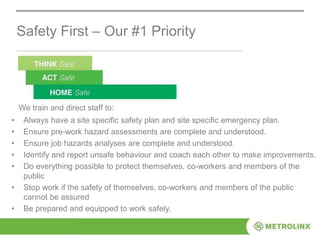
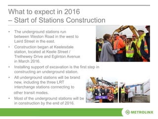
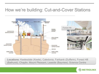
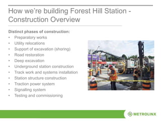
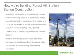
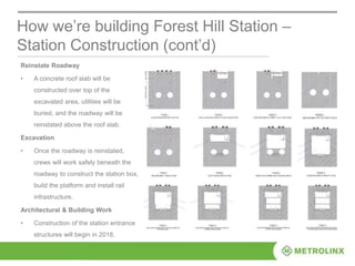
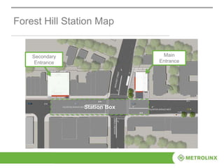
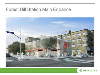
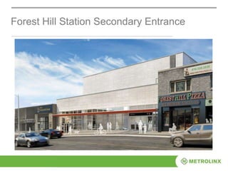
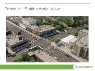
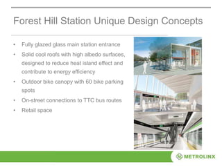
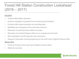
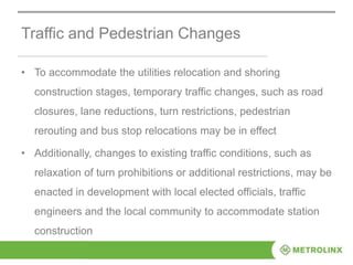
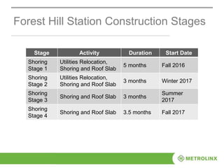
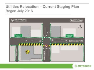
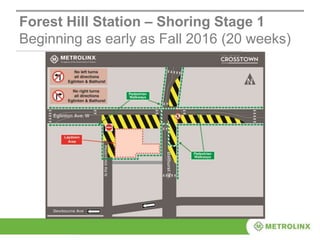
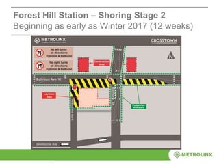
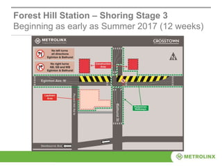
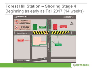
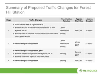
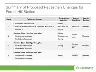
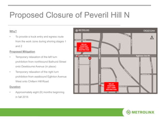
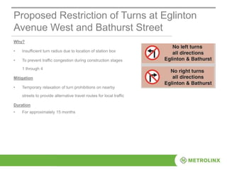
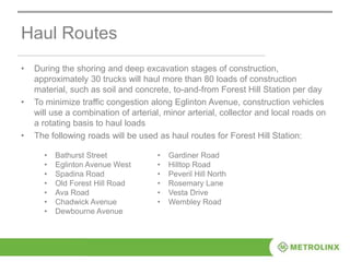
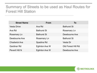
The document provides information about construction of the Forest Hill station for the Eglinton Crosstown LRT project in Toronto. Safety is the top priority during construction. The station will be built using a cut-and-cover method, requiring excavation below the road that will later be reinstated. Construction will occur in stages from 2016-2017, with traffic and pedestrian changes implemented to accommodate work zones. The station design includes entrances, a bike parking area, and potential retail space. Nearby roads will be used as haul routes during excavation and shoring stages.
10. Safety First – Our #1 Priority
• Always have a site specific safety plan and site specific emergency plan.
• Ensure pre-work hazard assessments are complete and understood.
• Ensure job hazards analyses are complete and understood.
• Identify and report unsafe behaviour and coach each other to make improvements.
• Do everything possible to protect themselves, co-workers and members of the
public
• Stop work if the safety of themselves, co-workers and members of the public
cannot be assured
• Be prepared and equipped to work safely.
We train and direct staff to:
11. Construction of the
Eglinton Crosstown LRT Line
Background
• In September 2008, Metrolinx
launched a regional transportation
plan – a 25-year, $50 billion plan -- to
coordinate and integrate transportation
and transit in the Greater Toronto Area
• In 2010, City of Toronto approved the
project to build the Eglinton Crosstown
from Weston Road in the west to
Kennedy Station in the east.
• Following a competitive process,
Crosslinx Transit Solutions (CTS) was
awarded a contract in July 2015 to
design, build, finance, and maintain
the Eglinton Crosstown Light Rail
Transit (LRT).
Benefits of P3s:
• The Crosstown is being delivered using a public
private partnership model called Alternative
Financing and Procurement (AFP).
• It was procured as one design-build-finance-
maintain project to minimize integration risk –
historically, a factor for project cost overruns
under traditional models.
• Under the AFP model, CTS assumes most
project risks, including:
design, project management and sub-
contractor coordination
increases in construction material prices
and labour costs
schedule and project completion delays
maintenance and lifecycle replacement of
materials within the stations and stops,
rails, control systems, and vehicles
13. What are we building – a new modern LRT
• 15 underground stations and 10 surface stops
• A maintenance and storage facility
• A 19-kilometre route separated from regular traffic
• Communications system
• Links to 54 bus routes, three subway stations, GO Transit, and a new UP Express station
15. Design Approach: Design from City to Object
15
S i m p l i c i t y
I conog ra phy
Transparency
Ur b a n i t y
Simplicity and elegance of the design solution at all scales,
from the city to the object;
Iconography of the architectural elements to create a unique
and highly recognizable signature on Eglinton Avenue, from
the slanted portal celebrating kinetic movement, to the
profiled wing delineating shelters and waiting areas;
Transparency of the entrances and through the station to magnify
the presence of natural light, to enact as a way-finding strategy
and to uplift the passenger’s experience;
Urbanity of the signature layers from landscape to architecture,
to underline the genius loci and contextualize the stations and
stops within the civic scale of the avenue.
17. 17
Clarity and Simplicity of Architectural
Expression
Street Level – Contextual &
Inviting
An International Signature
for Toronto
Entrance – Bright & Secure
Concourse – Simple &
Pristine
Concourse – Transparent &
Open
Platform – Spacious &
Animated
18. Crosstown Design Approach
Features
• About half of the 19 km line is
tunneled
• Stations and stops are about 0.6 km
apart
• Features will include:
• time arrival information
• safe access for people walking
and biking to the station
• clear route maps, seating, bike
parking
Design Approach
Comply with nine design principles developed
by City of Toronto and Metrolinx.
• Provide a legacy for generations to come.
• Have natural lighting during the day and well-lit
entrances at night.
• Have safe, clean, intuitive wayfinding at
all the stations and stops.
• Put passengers first.
• Provide visible entrances, bicycle facilities and
sustainable practices to ensure all stations
comply with Toronto Green Standard Tier.
• Landscaped entrances, including planters with
trees and ornamental grasses.
• Public plazas and retail components at some
stations.
• Clean and minimalist space at platform level.
• Accessible to passengers with disabilities,
strollers, and bicycles.
19. Accessibility for All
Station and stops are designed to support ease of access and use by persons with
differing levels of mobility, sight, hearing, sensory and cognitive abilities. The project site
and facilities are designed to be universally accessible including satisfying the
requirements of Accessibility for Ontarians with Disabilities Act (AODA) and applicable
City of Toronto Guidelines, Ontario Building Code (OBC) and Canadian Standards
Association (CSA) Standards. Some of these features include:
• Barrier‐free path from the entrance level to the station platform level
• Tactile warning strips and tactile walking surface indicators
• Signage system with tactile indicators
• Passenger Assistance Intercom (PAI)
• Low floor Light Rail Vehicle (LRV) with designated wheelchair locations
• Nominal gap from platform edge to LRV entry
• Automated visual and audible stop announcements
• On-street and off-street paratransit passenger pick-up/drop-off
20. • The underground stations run
between Weston Road in the west to
Laird Street in the east.
• Construction began at Keelesdale
station, located at Keele Street /
Trethewey Drive and Eglinton Avenue
in March 2016.
• Installing support of excavation is the first step in
constructing an underground station.
• All underground stations will be brand
new, including the three LRT
interchange stations connecting to
other transit modes.
• Most of the underground stations will be
in construction by the end of 2016.
What to expect in 2016
– Start of Stations Construction
21. How we’re building: Cut-and-Cover Stations
Forest Hill
Locations: Keelesdale (Keele), Caledonia, Fairbank (Dufferin), Forest Hill
(Bathurst), Chaplin, Mount Pleasant, Leaside (Bayview), Science Centre
23. • There are three
interchange stations.
• Interchange stations
will allow transit
riders to connect to
other transit modes,
such as TTC, GO
and the UP Express.
• The three
interchange stations
will be built with the
‘Cut and Cover’
method.
How we’re building – Interchange Stations
Subway Station Longitudinal Section
Locations: Cedarvale (Allen), Eglinton (Yonge), Kennedy
24. How we’re building Forest Hill Station -
Construction Overview
Distinct phases of construction:
• Preparatory works
• Utility relocations
• Support of excavation (shoring)
• Road restoration
• Deep excavation
• Underground station construction
• Track work and systems installation
• Station structure construction
• Traction power system
• Signalling system
• Testing and commissioning
25. • A modified version of the cut-and-cover method,
whereby following support of excavation, a large
concrete roof slab is constructed and placed over
top of the excavated area, the roadway is restored
and work continues safely below ground
• The roof slab is used to support utilities and the
roadway
• Benefits include reduction in road disruption
(compared to tradition method), increased utility
stability and improved safety and working
conditions
How we’re building Forest Hill Station –
Station Construction
26. Reinstate Roadway
• A concrete roof slab will be
constructed over top of the
excavated area, utilities will be
buried, and the roadway will be
reinstated above the roof slab.
Excavation
• Once the roadway is reinstated,
crews will work safely beneath the
roadway to construct the station box,
build the platform and install rail
infrastructure.
Architectural & Building Work
• Construction of the station entrance
structures will begin in 2018.
How we’re building Forest Hill Station –
Station Construction (cont’d)
31. Forest Hill Station Unique Design Concepts
• Fully glazed glass main station entrance
• Solid cool roofs with high albedo surfaces,
designed to reduce heat island effect and
contribute to energy efficiency
• Outdoor bike canopy with 60 bike parking
spots
• On-street connections to TTC bus routes
• Retail space
32. Forest Hill Station Tunnel Ventilation System (TVS)
• Designed to extract and control smoke from tunnels and stations in
the event of a fire.
• Controls excessive air velocities and air pressure transients.
• Removes heat and controls air temperature during operations.
• Supplies outdoor air ventilation and facilitates contaminant removal.
• Forest Hill Station TVS is comprised of axial fans, dampers,
electrical equipment, tunnel ventilation panels, supervisory control
and data acquisition (SCADA) interface, and Tunnel Ventilation Fire
Command Post.
• Vents are located on top of the secondary station entrance.
33. Forest Hill Station Construction Lookahead
(2016 – 2017)
Fall 2016
• Continue Bell utilities relocation
• Continue installation of geotechnical monitoring instrumentation
• Continue traffic signal relocation and reconfiguration
• Backfilling and compaction of the secondary entrance
• Relocation of overhead hydro utilities and poles
• Relocation of overhead Rogers utilities to an underground duct bank
• Site mobilization and drill rig/crane pad construction
• Support of excavation (shoring) beginning on the south side of Eglinton Avenue West
Winter 2016
• Continue shoring on the south side of Eglinton Avenue West
• Watermain services
34. Traffic and Pedestrian Changes
• To accommodate the utilities relocation and shoring
construction stages, temporary traffic changes, such as road
closures, lane reductions, turn restrictions, pedestrian
rerouting and bus stop relocations may be in effect
• Additionally, changes to existing traffic conditions, such as
relaxation of turn prohibitions or additional restrictions, may be
enacted in development with local elected officials, traffic
engineers and the local community to accommodate station
construction
35. Forest Hill Station Construction Stages
Stage Activity Duration Start Date
Shoring
Stage 1
Utilities Relocation,
Shoring and Roof Slab
5 months Fall 2016
Shoring
Stage 2
Utilities Relocation,
Shoring and Roof Slab
3 months Winter 2017
Shoring
Stage 3
Shoring and Roof Slab 3 months
Summer
2017
Shoring
Stage 4
Shoring and Roof Slab 3.5 months Fall 2017
37. Forest Hill Station – Shoring Stage 1
Beginning as early as Fall 2016 (20 weeks)
38. Forest Hill Station – Shoring Stage 2
Beginning as early as Winter 2017 (12 weeks)
39. Forest Hill Station – Shoring Stage 3
Beginning as early as Summer 2017 (12 weeks)
40. Forest Hill Station – Shoring Stage 4
Beginning as early as Fall 2017 (14 weeks)
41. Summary of Proposed Traffic Changes for Forest
Hill Station
Stage Traffic Changes
Construction
Activities
Approx.
Start Date
Approx.
Duration
1
• Close Peveril Hill N at Eglinton Ave W
• Restrict all turns at the intersection of Bathurst St and
Eglinton Ave W
• Reduce traffic to one lane in each direction on Bathurst St
and Eglinton Ave W
Utilities
Relocation &
shoring
Fall 2016 20 weeks
2 Continue Stage 1 configuration
Utilities
Relocation &
shoring
Winter
2017
12 weeks
3
Continue Stage 2 configuration, plus:
• Restore northbound right turn onto Eglinton Ave W
• Restore eastbound right turn onto Bathurst St
Shoring
Summer
2017
12 weeks
4 Continue Stage 3 configuration Shoring Fall 2017 14 weeks
42. Summary of Proposed Pedestrian Changes for
Forest Hill Station
Stage Pedestrian Changes
Construction
Activities
Approx.
Start Date
Approx.
Duration
1
• Restrict the east crosswalk
• Reroute pedestrians south on Peveril Hill N and east to
Bathurst St
Utilities
Relocation and
shoring
Fall 2016 20 weeks
2
Continue Stage 1 configuration, plus:
• Restore east crosswalk
• Restrict west crosswalk
Utilities
Relocation and
shoring
Winter
2017
12 weeks
3
Continue Stage 2 configuration, plus:
• Restore west crosswalk
• Restrict east crosswalk
Shoring
Summer
2017
12 weeks
4
Continue Stage 3 configuration, plus:
• Restore east crosswalk
• Restrict west crosswalk
Shoring Fall 2017 14 weeks
43. Proposed Closure of Peveril Hill N
Why?
• To provide a truck entry and egress route
from the work zone during shoring stages 1
and 2
Proposed Mitigation
• Temporary relaxation of the left turn
prohibition from northbound Bathurst Street
onto Dewbourne Avenue (in place)
• Temporary relaxation of the right turn
prohibition from eastbound Eglinton Avenue
West onto Chiltern Hill Road
Duration
• Approximately eight (8) months beginning
in fall 2016
RELAX
EXISITING
RIGHT TURN
RESTRICTION
RELAX
EXISITING
LEFT TURN
RESTRICTION
44. Proposed Restriction of Turns at Eglinton
Avenue West and Bathurst Street
Why?
• Insufficient turn radius due to location of station box
• To prevent traffic congestion during construction stages
1 through 4
Mitigation
• Temporary relaxation of turn prohibitions on nearby
streets to provide alternative travel routes for local traffic
Duration
• For approximately 15 months
45. Summary of Turn Prohibitions to be
considered for Temporary Relaxation
Prohibited
Movement
From To
Prohibited
Time
Right turn Eglinton Ave W (WB) Vesta Dr (NB) 7 AM – 6 PM
Right turn Eglinton Ave W (EB) Gardiner Rd (SB) 7 AM – 7 PM
Right turn Eglinton Ave W (EB) Old Forest Hill Rd (SB) 7 AM – 7 PM
(everyday)
Left turn Eglinton Ave W (WB) Old Forest Hill Rd (SB) 7 AM – 9 AM
Through traffic Old Forest Hill Rd (SB) @ Eglinton Ave W Peak Hours
Through traffic Old Forest Hill Rd (NB) @ Eglinton Ave W Peak Hours
Left turn Old Forest Hill Rd (NB) Eglinton Ave W (WB) Peak Hours
Left turn Bathurst St (SB) Burton St (EB) All Times
Right turn Ava Rd (WB) Bathurst St (NB) 4 PM – 6 PM
Left turn Bathurst St (NB) Avenal Dr (WB) Peak Hours
Left turn Bathurst St (NB) Dewbourne Ave (WB) Peak Hours
46. Summary of Turn Prohibitions to be considered for
Temporary Relaxation (cont’d)
Prohibited
Movement
From To
Prohibited
Time
Right turn Rosemary Ln (WB) Bathurst St (NB) 4 PM – 6 PM
Right turn Eglinton Ave W (EB) Chiltern Hill Rd (SB) Peak Hours
Right turn Eglinton Ave W (EB) Rostrevor Rd (SB) Peak Hours
Left turn Glen Cedar Rd (NB) Eglinton Ave W (WB) Peak Hours
Left turn Bathurst St (NB) Wembley Rd (WB) Peak Hours
Right turn Bathurst St (SB) Wembley Rd (WB) 7 AM – 9 AM
Left turn Bathurst St (SB) Shallmar Blvd (EB) 7 AM – 9 AM
Left turn Bathurst St (SB) Rosemary Ln (EB) 7 AM – 9 AM
Left turn Bathurst St (SB) Ava Rd (EB) 7 AM – 9 AM
47. Haul Routes
• During the shoring and deep excavation stages of construction,
approximately 30 trucks will haul more than 80 loads of construction
material, such as soil and concrete, to-and-from Forest Hill Station per day
• To minimize traffic congestion along Eglinton Avenue, construction vehicles
will use a combination of arterial, minor arterial, collector and local roads on
a rotating basis to haul loads
• The following roads will be used as haul routes for Forest Hill Station:
• Bathurst Street
• Eglinton Avenue West
• Spadina Road
• Old Forest Hill Road
• Ava Road
• Chadwick Avenue
• Dewbourne Avenue
• Gardiner Road
• Hilltop Road
• Peveril Hill North
• Rosemary Lane
• Vesta Drive
• Wembley Road
48. Summary of Streets to be used as Haul Routes for
Forest Hill Station
Street Name From To
Vesta Drive Ava Rd Bathurst St
Ava Rd Bathurst St Rosemary Ln
Rosemary Ln Bathurst St Dewbourne Ave
Dewbourne Ave Rosemary Ln Bathurst St
Chadwick Ave Spadina Rd Vesta Dr
Gardiner Rd Eglinton Ave W Old Forest Hill Rd
Peveril Hill N Eglinton Ave W Dewbourne Ave
49. Advanced Signage
• Advanced signage will be placed
along Eglinton Ave W and cross
streets to inform motorists and
pedestrians of traffic changes at the
intersection
• At Forest Hill Station, advanced
signage will be placed as far north
as Wembley Rd, as far south as
Dewbourne Ave, as far east as Old
Forest Hill Rd and as far west as
Chiltern Hill Rd
50. Bus Stop Relocations
Four (4) TTC bus stops at the four corners of Eglinton Avenue West and Bathurst
Street will be relocated throughout various stages of utilities relocation and shoring.
• The TTC bus stop on the southwest corner has been relocated approximately
140 meters to the east.
• The TTC bus stop on the southeast corner will be relocated approximately 90
meters to the north
• The TTC bus stop on the northwest corner will be relocated approximately 70
meters to the north
• The TTC bus stop on the northeast corner will be relocated approximately 50
meters to the east to the next available stop
The stops service the following TTC bus routes:
• 7/307 Bathurst North
• 310 Bathurst South
• 32/332 Eglinton West
Please look for signage informing passengers of the new temporary stop locations.
51. TTC Bus Stop Relocation Map
Relocate 50m
east to next
stop
Relocated
140m east
Relocate 90m
northRelocate 70m
north
52. TTC Bus Route 33 Detour
• To accommodate construction staging
at Forest Hill Station, TTC bus route #
33 will be detour north on Mayfair
Avenue and west on Shallmar
Boulevard to Bathurst Street
• The approximate duration of the
detour is 15 months, beginning as
early as October 2016
• Changes to traffic calming conditions
on Mayfair Avenue and Shallmar
Boulevard will be implemented
53. Experience Eglinton
Advertising and marketing initiatives, ranging
from subway and local newspapers advertisements,
to postcards, coupon booklets and flyers all focused
on encouraging residents in the neighbourhood
to shop locally.
Support for Businesses – Shop Local
54. Community Benefits
Commit to Social Procurement and Local Investment
to maximize business opportunities along the project corridor.
Visit CTS’ website www.crosslinxtransit.ca for updated postings.
The Eglinton Crosstown LRT is the first time a Community Benefits Framework
has been included as part of a major infrastructure project in Ontario.
Partner with Local Workforce Agencies
to recruit candidates from the project corridor and from
historically disadvantaged communities.
Work with Subcontractors
to maximize opportunities for apprentices.
Laird Station will be an underground station located at the intersection of Laird Drive and Eglinton Avenue East. The station will also be a turnback station and will have special trackwork for LRT operations.
A turnback station allows trains to change directions. The special trackwork allows a train to be stored between the tracks. For example, a disabled train could be stored there so it does not disrupt service.
The main, fully accessible entrance will be located at the southwest corner of Eglinton Avenue and Laird Drive. This entrance will also include a station plaza and retail spaces at street level. The secondary entrance will be located south of Eglinton Avenue East, just east of Laird Drive.
There will be on-street connections to TTC buses, and 60 outdoor bicycle parking spaces.
June 1, 2016
Utilities relocation
Removal of one hydro pole on south west corner
Relocation of light poles along Laird Drive and on the south side of Eglinton Avenue East
Two long-term one
lane closures anticipated, one at the main shaft and another
at the secondary shaft. Four sidewalk closures are
anticipated; all other sidewalks will be maintained along with
business accesses. One bus stop relocations as per Stage 1
will continue to be maintained.
Two long-term one
lane closures anticipated, one at the main shaft and another
at the secondary shaft. Four sidewalk closures are
anticipated; all other sidewalks will be maintained along with
business accesses. One bus stop relocations as per Stage 1
will continue to be maintained.