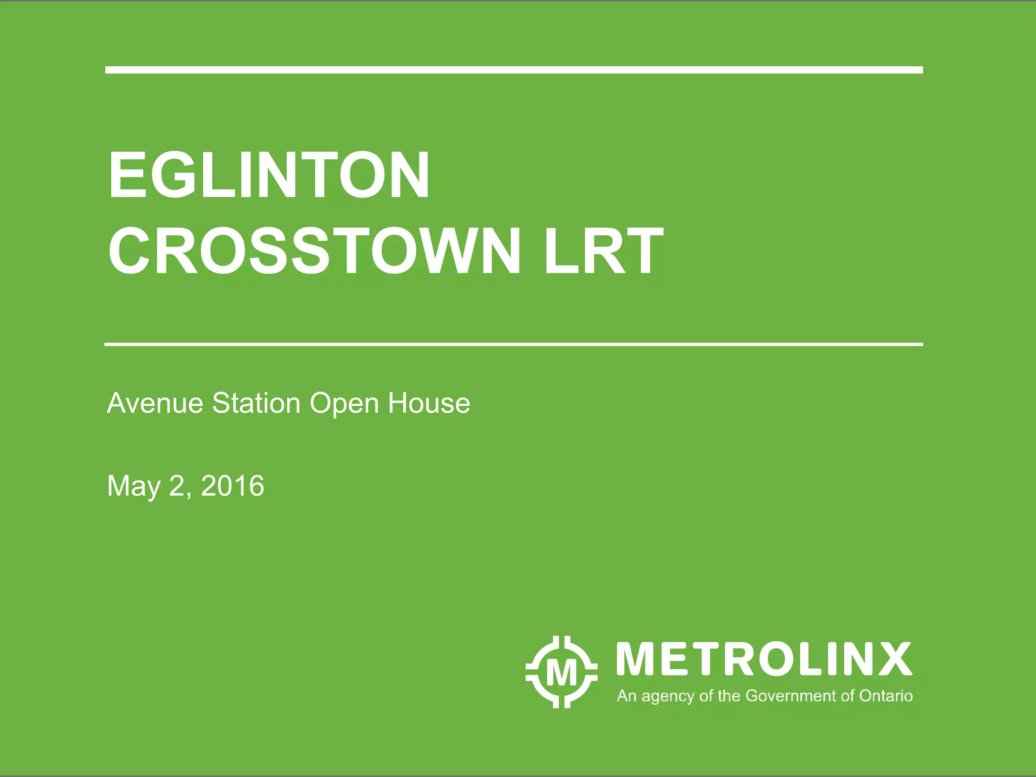
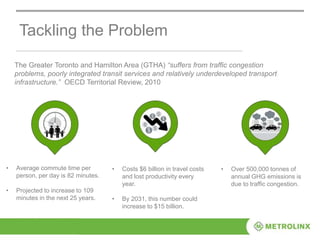
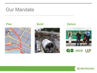
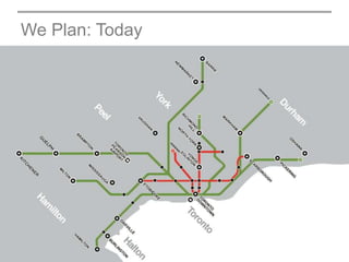
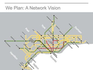
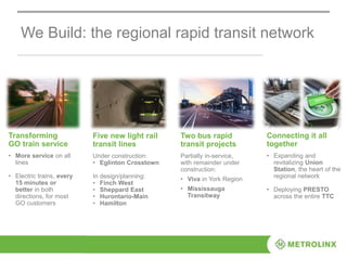
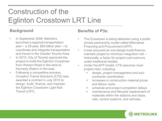
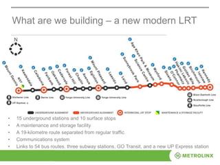
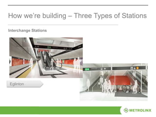
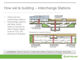
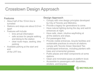
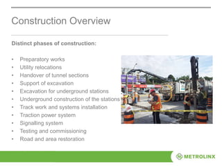
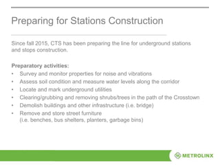
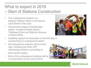
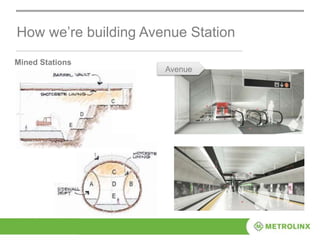
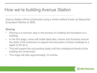
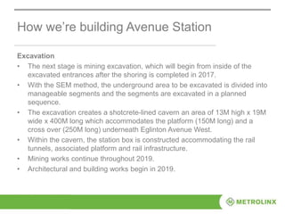
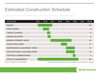
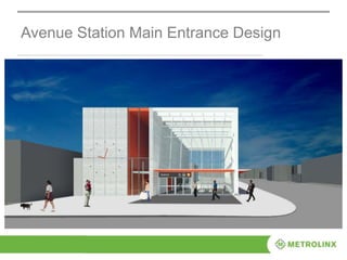
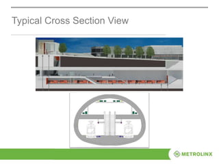
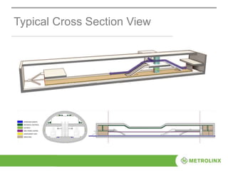
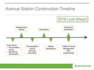
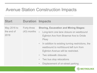
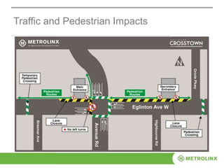
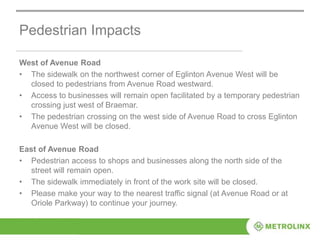
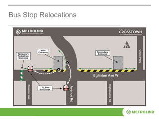
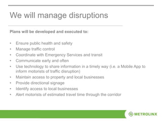
2. Tackling the Problem
The Greater Toronto and Hamilton Area (GTHA) “suffers from traffic congestion
problems, poorly integrated transit services and relatively underdeveloped transport
infrastructure.” OECD Territorial Review, 2010
• Average commute time per
person, per day is 82 minutes.
• Projected to increase to 109
minutes in the next 25 years.
• Costs $6 billion in travel costs
and lost productivity every
year.
• By 2031, this number could
increase to $15 billion.
• Over 500,000 tonnes of
annual GHG emissions is
due to traffic congestion.
3. Metrolinx was created in 2006 by the Province of Ontario as the first regional
transportation agency for the Greater Toronto and Hamilton Area.
We were created to deal with congestion and provide one vision for the region: a
transformation vision.
Regional Solution
1
Deliver the best possible
transportation services
today while leading the
way to an even better,
more convenient service
tomorrow.
2 3
Make the best possible use
of public transportation
investment dollars.
Measurably improve
quality of life in our
region.
7. We Build: the regional rapid transit network
Two bus rapid
transit projects
Partially in-service,
with remainder under
construction:
• Viva in York Region
• Mississauga
Transitway
Five new light rail
transit lines
Under construction:
• Eglinton Crosstown
In design/planning:
• Finch West
• Sheppard East
• Hurontario-Main
• Hamilton
Transforming
GO train service
• More service on all
lines
• Electric trains, every
15 minutes or
better in both
directions, for most
GO customers
Connecting it all
together
• Expanding and
revitalizing Union
Station, the heart of the
regional network
• Deploying PRESTO
across the entire TTC
8. Union Station Revitalization
Improvements: new train shed
roof & track replacements
Georgetown South Project
Improvements: three new tracks
along 20kms
Bus Rapid Transit
New kms: 59
Ridership (2031): 3800+/hour
Eglinton Crosstown LRT
New kms: 19
Ridership (2031): 5500/hour
UP Express
Approximately 25 km
Ridership: up to 5000/day
PRESTO
Card Holders: 1,000,000+
Availability: 10 transit agencies
Major Projects Completed or Underway
9. Safety First – Our #1 Priority
• Always have a site specific safety plan and site specific emergency plan.
• Ensure pre-work hazard assessments are complete and understood.
• Ensure job hazards analyses are complete and understood.
• Do everything reasonably possible to protect themselves, co-workers, and
members of the public.
• Identify and report unsafe behaviour and coach each other to make
improvements.
• Be prepared and equipped to work safely.
We train and direct staff to:
10. Construction of the
Eglinton Crosstown LRT Line
Background
• In September 2008, Metrolinx
launched a regional transportation
plan – a 25-year, $50 billion plan -- to
coordinate and integrate transportation
and transit in the Greater Toronto Area
• In 2010, City of Toronto approved the
project to build the Eglinton Crosstown
from Weston Road in the west to
Kennedy Station in the east.
• Following a competitive process,
Crosslinx Transit Solutions (CTS) was
awarded a contract in July 2015 to
design, build, finance, and maintain
the Eglinton Crosstown Light Rail
Transit (LRT).
Benefits of P3s:
• The Crosstown is being delivered using a public
private partnership model called Alternative
Financing and Procurement (AFP).
• It was procured as one design-build-finance-
maintain project to minimize integration risk –
historically, a factor for project cost overruns
under traditional models.
• Under the AFP model, CTS assumes most
project risks, including:
design, project management and sub-
contractor coordination
increases in construction material prices
and labour costs
schedule and project completion delays
maintenance and lifecycle replacement of
materials within the stations and stops,
rails, control systems, and vehicles
12. What are we building – a new modern LRT
• 15 underground stations and 10 surface stops
• A maintenance and storage facility
• A 19-kilometre route separated from regular traffic
• Communications system
• Links to 54 bus routes, three subway stations, GO Transit, and a new UP Express station
14. Design Approach: Design from City to Object
S i m p l i c i t y
I conog ra phy
Transparency
Ur b a n i t y
Simplicity and elegance of the design solution at all scales,
from the city to the object;
Iconography of the architectural elements to create a unique
and highly recognizable signature on Eglinton Avenue, from
the slanted portal celebrating kinetic movement, to the
profiled wing delineating shelters and waiting areas;
Transparency of the entrances and through the station to magnify
the presence of natural light, to enact as a way-finding strategy
and to uplift the passenger’s experience;
Urbanity of the signature layers from landscape to architecture,
to underline the genius loci and contextualize the stations and
stops within the civic scale of the avenue.
15. How we’re building – Three Types of Stations
Cut & Cover Stations
Chaplin
Locations: Keelesdale (Keele), Caledonia, Fairbank (Dufferin), Forest Hill
(Bathurst), Chaplin, Mount Pleasant, Leaside (Bayview), Science Centre
16. How we’re building – Three Types of Stations
Mined Stations
Avenue
tLocations: Oakwood, Avenue, Leaside (part), Laird
17. How we’re building – Three Types of Stations
Interchange Stations
Eglinton
18. • There are four
interchange stations.
• Interchange stations
will allow transit
riders to connect to
other transit modes,
such as TTC, GO
and the UP Express
How we’re building – Interchange Stations
Subway Station Longitudinal Section
Locations: Mount Dennis, Cedarvale (Allen), Eglinton (Yonge), Kennedy
20. Clarity and Simplicity of Architectural
Expression
Street Level – Contextual
and Inviting
An International Signature
for Toronto
Entrance – Bright & Secure
Concourse – Simple &
Pristine
Concourse – Transparent &
Open
Platform – Spacious &
Animated
21. Crosstown Design Approach
Features
• About half of the 19 km line is
tunneled
• Stations and stops are about 0.6 km
apart
• Features will include:
• time arrival information
• safe access for people walking
and biking to the station
• clear route maps, seating, bike
parking
• Available parking at the start and
end
of the LRT line.
Design Approach
• Comply with nine design principles developed
by City of Toronto and Metrolinx.
• Provide a legacy for generations to come.
• Have natural lighting during the day and well-lit
entrances at night.
• Have safe, clean, intuitive wayfinding at
all the stations and stops.
• Put passengers first.
• Provide visible entrances, bicycle facilities and
sustainable practices to ensure all stations
comply with Toronto Green Standard Tier.
• Landscaped entrances, including planters with
trees and ornamental grasses.
• Public plazas and retail components at some
stations.
• Clean and minimalist space at platform level.
• Accessible to passengers with disabilities,
strollers, and bicycles.
22. Construction Overview
Distinct phases of construction:
• Preparatory works
• Utility relocations
• Handover of tunnel sections
• Support of excavation
• Excavation for underground stations
• Underground construction of the stations
• Track work and systems installation
• Traction power system
• Signalling system
• Testing and commissioning
• Road and area restoration
23. Preparing for Stations Construction
Since fall 2015, CTS has been preparing the line for underground stations
and stops construction.
Preparatory activities:
• Survey and monitor properties for noise and vibrations
• Assess soil condition and measure water levels along the corridor
• Locate and mark underground utilities
• Clearing/grubbing and removing shrubs/trees in the path of the Crosstown
• Demolish buildings and other infrastructure (i.e. bridge)
• Remove and store street furniture
(i.e. benches, bus shelters, planters, garbage bins)
24. • The underground stations run
between Weston Road in the west to
Laird Street in the east.
• Construction began at Keelesdale
station, located at Keele Street /
Trethewey Drive and Eglinton Avenue
in March 2016.
• Installing support of excavation is the first step in
constructing an underground station.
• All underground stations will be brand
new, including the three LRT
interchange stations connecting to
other transit modes.
• Most of the underground stations will be
in construction by the end of 2016.
What to expect in 2016
– Start of Stations Construction
26. Avenue Station will be constructed using a mined method known as Sequential
Excavation Method or SEM.
Shoring
• Shoring is a common step in the process of installing the foundation of a
building.
• In the first stage, crews will install steel piles, braces and tie-backs around
the sides of the entrances to support the excavation of these buildings to a
depth of 25-30 m.
• This will support the surrounding loads until the underground levels of the
building are constructed.
• This stage will take approximately 12 months.
How we’re building Avenue Station
27. How we’re building Avenue Station
Excavation
• The next stage is mining excavation, which will begin from inside of the
excavated entrances after the shoring is completed in 2017.
• With the SEM method, the underground area to be excavated is divided into
manageable segments and the segments are excavated in a planned
sequence.
• The excavation creates a shotcrete-lined cavern an area of 13M high x 19M
wide x 400M long which accommodates the platform (150M long) and a
cross over (250M long) underneath Eglinton Avenue West.
• Within the cavern, the station box is constructed accommodating the rail
tunnels, associated platform and rail infrastructure.
• Mining works continue throughout 2019.
• Architectural and building works begin in 2019.
37. Avenue Station Construction Timeline
2016 Look Ahead
Geotechnical
Testing
Pre-demolition
work &
Chimney
Demolition
Demolitions
Utilities
Relocations
Support of
Excavation
Traffic & Transit
Management
Plan
Implemented
Early Works
- Pre-condition
survey
- Monitoring
Instruments
38. Avenue Station Construction Impacts
Start Duration Impacts
May 2016 to
the end of
2019
Forty-three
(43) months
Shoring, Excavation and Mining Stages:
• Long-term one lane closure on westbound
Eglinton Ave from Braemar Ave to Oriole
Pkwy
• In addition to existing turning restrictions, the
eastbound to northbound left turn from
Eglinton Avenue will be restricted.
• Two sidewalk closures
• Two bus stop relocations
• Displacement of on-street parking
40. Pedestrian Impacts
West of Avenue Road
• The sidewalk on the northwest corner of Eglinton Avenue West will be
closed to pedestrians from Avenue Road westward.
• Access to businesses will remain open facilitated by a temporary pedestrian
crossing just west of Braemar.
• The pedestrian crossing on the west side of Avenue Road to cross Eglinton
Avenue West will be closed.
East of Avenue Road
• Pedestrian access to shops and businesses along the north side of the
street will remain open.
• The sidewalk immediately in front of the work site will be closed.
• Please make your way to the nearest traffic signal (at Avenue Road or at
Oriole Parkway) to continue your journey.
42. We will manage disruptions
Plans will be developed and executed to:
• Ensure public health and safety
• Manage traffic control
• Coordinate with Emergency Services and transit
• Communicate early and often
• Use technology to share information in a timely way (i.e. a Mobile App to
inform motorists of traffic disruption)
• Maintain access to property and local businesses
• Provide directional signage
• Identify access to local businesses
• Alert motorists of estimated travel time through the corridor
This is what congestion means in terms of lost time, inefficiencies to the region
Metrolinx was created to deal with this problem and provide one vision for the region: a transformation vision
Metrolinx does three things: plan, build, deliver
(you go into each in the following slides)
This map shows the existing regional rapid transit network.
(click to reveal the 25-year plan)
we have a 25 year regional transportation plan; this is not a plan that sits on a shelf; this is a plan that delivers real results.
This shows the network proposed in the 25-Year Plan of The Big Move Regional Transportation Plan.
The Big Move’s vision is an integrated transportation system for the region that enhances prosperity, sustainability and quality of life.
It contains close to 100 priority actions and supporting policies with plans for over 1,200 kilometres of rapid transit (more than triple what existed in 2008).
8
13M x 19M 400M long station 150M (cross over 250M) where the trains