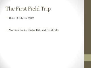
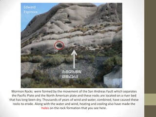
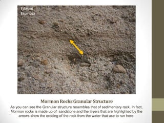
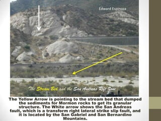
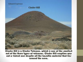
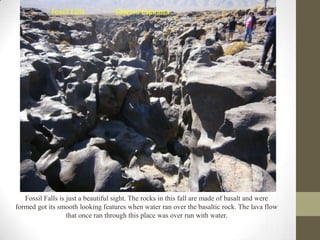
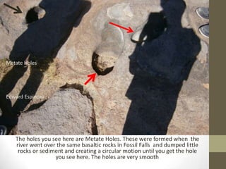
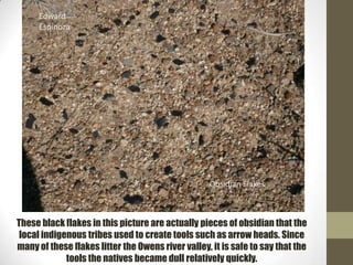
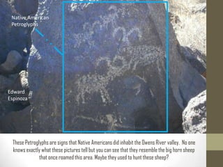
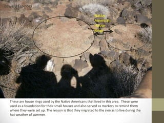
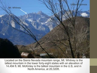
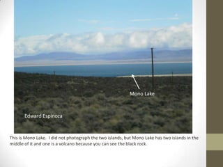
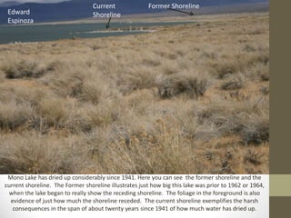
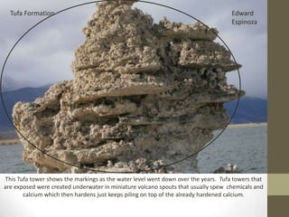
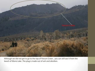
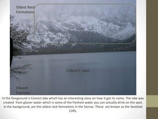
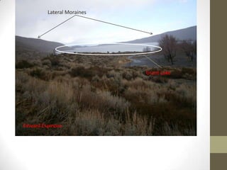
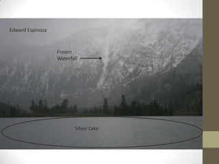
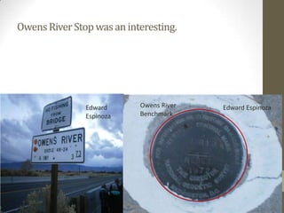
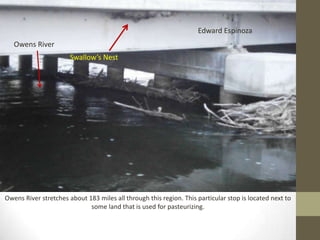
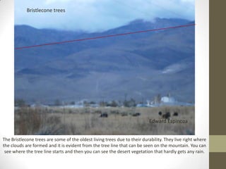
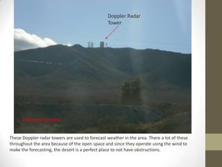
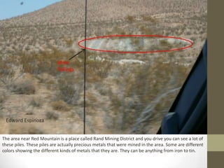
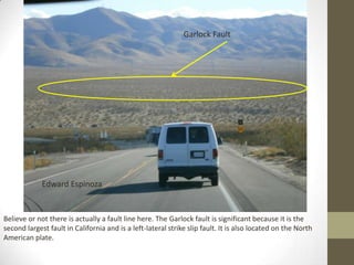
Field Journal
       By: Edward Espinoza

*This is a Sun
Dog or a
Parhelion. Can
be seen when
the sun is lowest
in the sky.
                             Edward
                             Espinoza


Geography-5
Professor Schmidt
Fridays 1:00-2:50 PM
The First Field Trip
• Date: October 6, 2012


• Mormon Rocks, Cinder Hill, and Fossil Falls
Edward
         Espinoza


                                     Mormon
                                     Rocks


 Mormon Rocks were formed by the movement of the San Andreas Fault which separates
  the Pacific Plate and the North American plate and these rocks are located on a river bed
that has long been dry. Thousands of years of wind and water, combined, have caused these
   rocks to erode. Along with the water and wind, heating and cooling also have made the
                        holes on the rock formation that you see here.
Edward
      Espinoza


                  Mormon Rocks Granular Structure
As you can see the Granular structure resembles that of sedimentary rock. In fact,
Mormon rocks is made up of sandstone and the layers that are highlighted by the
     arrows show the eroding of the rock from the water that use to run here.
Edward Espinoza


         The Stream Bed and the San Andreas Rift Zone
The Yellow Arrow is pointing to the stream bed that dumped
    the sediments for Mormon rocks to get its granular
    structure. The White arrow shows the San Andreas
fault, which is a transform right lateral strike slip fault, and
    it is located by the San Gabriel and San Bernardino
                          Mountains.
Cinder Hill
Edward Espinoza
                     Cinder Hill


Cinder Hill is a Cinder Volcano, which is one of the smallest
out of the three types of volcanos. Cinder Hill eruption was
 not a violent one despite all the basaltic material that lies
                      around the area.
Lava Flow


                                                                          Edward
                                                                          Espinoza
This Lava Flow that once poured through this mountain is made up of extrusive rock. This
 lava flow is, specifically, made of basaltic rock, which is also found deepest parts of the
       ocean near oceanic ridges. Extrusive rock is one of two types of Igneous rock.
Fossil Falls
Fossil Falls           Edward Espinoza


   Fossil Falls is just a beautiful sight. The rocks in this fall are made of basalt and were
formed got its smooth looking features when water ran over the basaltic rock. The lava flow
                   that once ran through this place was over run with water.
Metate Holes


Edward Espinoza


   The holes you see here are Metate Holes. These were formed when the
   river went over the same basaltic rocks in Fossil Falls and dumped little
    rocks or sediment and creating a circular motion until you get the hole
                  you see here. The holes are very smooth  .
Edward
     Espinoza


                                                   Obsidian Flakes


These black flakes in this picture are actually pieces of obsidian that the
 local indigenous tribes used to create tools such as arrow heads. Since
many of these flakes litter the Owens river valley, it is safe to say that the
             tools the natives became dull relatively quickly.
Native American
 Petroglyphs


Edward
Espinoza


 These Petroglyphs are signs that Native Americans did inhabit the Owens River valley. No one
 knows exactly what these pictures tell but you can see that they resemble the big horn sheep
              that once roamed this area. Maybe they used to hunt these sheep?
Edward Espinoza

                                                            Native
                                                            American
                                                            House
                                                            Rings


  These are house rings used by the Native Americans that lived in this area. These were
  used as a foundation for their small houses and also served as markers to remind them
  where they were set up. The reason is that they migrated to the sierras to live during the
  hot weather of summer.
The Second Trip
• Date: November 16-18, 2012

• Mt. Whitney Interagency Visitors
  Center, Diaz Lake, Manzanar, Convict
  Lake, Keoughs Hot Springs, The June Lake
  Loop, Owens River Stop, and the Eastern
  California Museum.
Mt. Whitney Interagency
Visitors Center
Edward Espinoza
   Mt. Whitney


Located on the Sierra Nevada mountain range, Mt. Whitney is the
tallest mountain in the lower forty-eight states with an elevation of
 14,494 ft. Mt. McKinley is the tallest mountain in the U.S, and in
                     North America, at 20,320ft.
The red circle highlights the orographic effect occurring on the Sierra Nevada
mountains. The sierra’s closer to the coast which allows the wind to carry a
lot of moisture and in effect when the air moves up and over the mountains, a
lot of moisture, due to high elevations in the form of snow or rain, can be
dumped on top of them. The valley will not see any of this moisture.


           Edward Espinoza
Inyo-white mountains and
the Alluvial fan.          Edward Espinoza
Edward Espinoza


      Diaz Lake


This is Diaz Lake and it was formed in 1872 when a massive earthquake made the land into a sag-
pond. Diaz lake is located on the down sag-pond which means that the ground dropped lower then
                                         the Alabama Hills.
Edward Espinoza
      Lone Pine Fault


Lone Pine Fault caused a major earthquake in 1872. The earthquake caused the area to create a
 sag pond, which means that the area where Diaz lake is dropped a significant amount of feet.
   Also the Lone Pine fault is rocks pushing the rocks up which is making the Alabama Hills.
Keoughs Hot Springs
Keoughs
     Hot
     Springs


       Edward Espinoza


 Keoughs Hot springs is just outside Big Pine. This water was warm to the touch but some hot
springs can get really hot. Keoughs is warmed by the water running underground and the water
                   then flows close to magma and returns back to the surface.
Mono Lake
Mono Lake


       Edward Espinoza


This is Mono Lake. I did not photograph the two islands, but Mono Lake has two islands in the
middle of it and one is a volcano because you can see the black rock.
Current              Former Shoreline
 Edward                           Shoreline
 Espinoza


 Mono Lake has dried up considerably since 1941. Here you can see the former shoreline and the
current shoreline. The Former shoreline illustrates just how big this lake was prior to 1962 or 1964,
 when the lake began to really show the receding shoreline. The foliage in the foreground is also
  evidence of just how much the shoreline receded. The current shoreline exemplifies the harsh
   consequences in the span of about twenty years since 1941 of how much water has dried up.
Tufa Formation                                                                    Edward
                                                                                    Espinoza


This Tufa tower shows the markings as the water level went down over the years. Tufa towers that
are exposed were created underwater in miniature volcano spouts that usually spew chemicals and
       calcium which then hardens just keeps piling on top of the already hardened calcium.
Panum Crater


     Edward Espinoza

Although we did not get to go to the top of Panum Crater , you can still see it from the
beach of Mono Lake. The plug is made out of ash and obsidian.
Convict Lake
Oldest Rock
         Formations


                                             CONVICT LAKE


         Edward
         Espinoza
In the foreground is Convict lake which has an interesting story on how it got its name. The lake was
 created from glacier water which is some of the freshest water you can actually drink on the spot.
 In the background, are the oldest rock formations in the Sierras. These are known as the Sevehah
                                                Cliffs.
June Lake Loop
Lateral Moraines


                            Grant Lake


Edward Espinoza
Edward Espinoza


                  Frozen
                  Waterfall


                          Silver Lake
Owens River Stop
Owens River Stop was an interesting.


               Edward      Owens River   Edward Espinoza
               Espinoza    Benchmark
Edward Espinoza
   Owens River
                       Swallow’s Nest


Owens River stretches about 183 miles all through this region. This particular stop is located next to
                             some land that is used for pasteurizing.
Bristlecone trees


                                                                          Edward Espinoza


The Bristlecone trees are some of the oldest living trees due to their durability. They live right where
the clouds are formed and it is evident from the tree line that can be seen on the mountain. You can
 see where the tree line starts and then you can see the desert vegetation that hardly gets any rain.
Eastern California Museum
When I entered the Eastern California Museum, I found a lot of things
interesting. The first display I found interesting was the Manzanarexhibit. I
got to see the photographs of the Japanese-American citizens that were held
captive in this camp. Each photograph displayed a day in the life of these
prisoners and showed how they coped with being wrongfully imprisoned, in
my opinion. The exhibit also displayed furniture and radios that these
American citizens used everyday. Some of the chairs are about 70 years old. It
is amazing that they actually sat on one of these chairs on a hot summer day
trying to cool off in the shade of their barracks.


    Edward
    Espinoza                                           Edward
                                                       Espinoza
Wondering through the Eastern California Museum, I found a display of this
magnificent gun collection from the 1800’s to about the early 1900’s. It was
extraordinary to see these guns up close. Although I couldn’t shoot them looking at
them from this close of distance was good enough for me. They even had one of my
favorite guns from the late 1800’s which is the 1873 Winchester Repeater. This display
really reminded me of the Wild West. While the gun collection was behind a glass
frame, the music box on the right was something that could be examined a bit more
close. The music box was in excellent condition and on of the curators at the museum
actually turned it on. The sound that proceeded was vintage and I was really glad I got
to hear it in action. These were the first record players, in a sense, before vinyl.
Manzanar Internment Camp-                         Manzanar was an
internment camp set up to house about 10,000 Japanese-American citizens
during World War II.


                                                     Guard Shacks


                                         Edward
   Edward Espinoza                       Espinoza
Edward Espinoza


Most of the Japanese that built the area around them left their names, initials, dates, or even a
message in cement like this one here. The area where this photograph was taken used to be a
 community center of some sort. There is nothing left except rocks in what appears to be in
                    formations to signal that buildings once stood there.
Extras and the In Transit-
Optional
Edward Espinoza


                  This is the
Doppler Radar
                                                 Tower


      Edward Espinoza


These Doppler radar towers are used to forecast weather in the area. There a lot of these
throughout the area because of the open space and since they operate using the wind to
make the forecasting, the desert is a perfect place to not have obstructions.
Mine
                           Tailings


 Edward Espinoza


The area near Red Mountain is a place called Rand Mining District and you drive you can see a lot of
these piles. These piles are actually precious metals that were mined in the area. Some are different
colors showing the different kinds of metals that they are. They can be anything from iron to tin.
Garlock Fault


             Edward Espinoza


Believe or not there is actually a fault line here. The Garlock fault is significant because it is the
second largest fault in California and is a left-lateral strike slip fault. It is also located on the North
American plate.
Joshua Trees                    Edward Espinoza


                          Burroweed


          Creosote Bush
Edward Espinoza
            California
            Aqueduct


This is the California Aqueduct.
Owens Dry Lake


       Edward Espinoza
This is just a little glimpse of Owens Lake. It used to be the biggest lake in California, but in the early
1900’s Los Angeles needed to sustain a growing population and used all the water in this lake.
Within a few decades, the lake became dry and other problems arose. One problem was the loose
sediment at the lake bed that causes severe and even toxic dust storms which led to a lawsuit.
SETI Towers


                                                                         Edward Espinoza


These are the SETI (Search for Extraterrestrial Intelligence) Towers and they are used to look out for
communications from outer space, preferably aliens.

Field journal geo 5

  • 1.
    Field Journal By: Edward Espinoza *This is a Sun Dog or a Parhelion. Can be seen when the sun is lowest in the sky. Edward Espinoza Geography-5 Professor Schmidt Fridays 1:00-2:50 PM
  • 2.
    The First FieldTrip • Date: October 6, 2012 • Mormon Rocks, Cinder Hill, and Fossil Falls
  • 3.
    Edward Espinoza Mormon Rocks Mormon Rocks were formed by the movement of the San Andreas Fault which separates the Pacific Plate and the North American plate and these rocks are located on a river bed that has long been dry. Thousands of years of wind and water, combined, have caused these rocks to erode. Along with the water and wind, heating and cooling also have made the holes on the rock formation that you see here.
  • 4.
    Edward Espinoza Mormon Rocks Granular Structure As you can see the Granular structure resembles that of sedimentary rock. In fact, Mormon rocks is made up of sandstone and the layers that are highlighted by the arrows show the eroding of the rock from the water that use to run here.
  • 5.
    Edward Espinoza The Stream Bed and the San Andreas Rift Zone The Yellow Arrow is pointing to the stream bed that dumped the sediments for Mormon rocks to get its granular structure. The White arrow shows the San Andreas fault, which is a transform right lateral strike slip fault, and it is located by the San Gabriel and San Bernardino Mountains.
  • 6.
  • 7.
    Edward Espinoza Cinder Hill Cinder Hill is a Cinder Volcano, which is one of the smallest out of the three types of volcanos. Cinder Hill eruption was not a violent one despite all the basaltic material that lies around the area.
  • 8.
    Lava Flow Edward Espinoza This Lava Flow that once poured through this mountain is made up of extrusive rock. This lava flow is, specifically, made of basaltic rock, which is also found deepest parts of the ocean near oceanic ridges. Extrusive rock is one of two types of Igneous rock.
  • 9.
  • 10.
    Fossil Falls Edward Espinoza Fossil Falls is just a beautiful sight. The rocks in this fall are made of basalt and were formed got its smooth looking features when water ran over the basaltic rock. The lava flow that once ran through this place was over run with water.
  • 11.
    Metate Holes Edward Espinoza The holes you see here are Metate Holes. These were formed when the river went over the same basaltic rocks in Fossil Falls and dumped little rocks or sediment and creating a circular motion until you get the hole you see here. The holes are very smooth .
  • 12.
    Edward Espinoza Obsidian Flakes These black flakes in this picture are actually pieces of obsidian that the local indigenous tribes used to create tools such as arrow heads. Since many of these flakes litter the Owens river valley, it is safe to say that the tools the natives became dull relatively quickly.
  • 13.
    Native American Petroglyphs Edward Espinoza These Petroglyphs are signs that Native Americans did inhabit the Owens River valley. No one knows exactly what these pictures tell but you can see that they resemble the big horn sheep that once roamed this area. Maybe they used to hunt these sheep?
  • 14.
    Edward Espinoza Native American House Rings These are house rings used by the Native Americans that lived in this area. These were used as a foundation for their small houses and also served as markers to remind them where they were set up. The reason is that they migrated to the sierras to live during the hot weather of summer.
  • 15.
    The Second Trip •Date: November 16-18, 2012 • Mt. Whitney Interagency Visitors Center, Diaz Lake, Manzanar, Convict Lake, Keoughs Hot Springs, The June Lake Loop, Owens River Stop, and the Eastern California Museum.
  • 16.
  • 17.
    Edward Espinoza Mt. Whitney Located on the Sierra Nevada mountain range, Mt. Whitney is the tallest mountain in the lower forty-eight states with an elevation of 14,494 ft. Mt. McKinley is the tallest mountain in the U.S, and in North America, at 20,320ft.
  • 18.
    The red circlehighlights the orographic effect occurring on the Sierra Nevada mountains. The sierra’s closer to the coast which allows the wind to carry a lot of moisture and in effect when the air moves up and over the mountains, a lot of moisture, due to high elevations in the form of snow or rain, can be dumped on top of them. The valley will not see any of this moisture. Edward Espinoza
  • 19.
    Inyo-white mountains and theAlluvial fan. Edward Espinoza
  • 20.
    Edward Espinoza Diaz Lake This is Diaz Lake and it was formed in 1872 when a massive earthquake made the land into a sag- pond. Diaz lake is located on the down sag-pond which means that the ground dropped lower then the Alabama Hills.
  • 21.
    Edward Espinoza Lone Pine Fault Lone Pine Fault caused a major earthquake in 1872. The earthquake caused the area to create a sag pond, which means that the area where Diaz lake is dropped a significant amount of feet. Also the Lone Pine fault is rocks pushing the rocks up which is making the Alabama Hills.
  • 22.
  • 23.
    Keoughs Hot Springs Edward Espinoza Keoughs Hot springs is just outside Big Pine. This water was warm to the touch but some hot springs can get really hot. Keoughs is warmed by the water running underground and the water then flows close to magma and returns back to the surface.
  • 24.
  • 25.
    Mono Lake Edward Espinoza This is Mono Lake. I did not photograph the two islands, but Mono Lake has two islands in the middle of it and one is a volcano because you can see the black rock.
  • 26.
    Current Former Shoreline Edward Shoreline Espinoza Mono Lake has dried up considerably since 1941. Here you can see the former shoreline and the current shoreline. The Former shoreline illustrates just how big this lake was prior to 1962 or 1964, when the lake began to really show the receding shoreline. The foliage in the foreground is also evidence of just how much the shoreline receded. The current shoreline exemplifies the harsh consequences in the span of about twenty years since 1941 of how much water has dried up.
  • 27.
    Tufa Formation Edward Espinoza This Tufa tower shows the markings as the water level went down over the years. Tufa towers that are exposed were created underwater in miniature volcano spouts that usually spew chemicals and calcium which then hardens just keeps piling on top of the already hardened calcium.
  • 28.
    Panum Crater Edward Espinoza Although we did not get to go to the top of Panum Crater , you can still see it from the beach of Mono Lake. The plug is made out of ash and obsidian.
  • 29.
  • 30.
    Oldest Rock Formations CONVICT LAKE Edward Espinoza In the foreground is Convict lake which has an interesting story on how it got its name. The lake was created from glacier water which is some of the freshest water you can actually drink on the spot. In the background, are the oldest rock formations in the Sierras. These are known as the Sevehah Cliffs.
  • 31.
  • 32.
    Lateral Moraines Grant Lake Edward Espinoza
  • 33.
    Edward Espinoza Frozen Waterfall Silver Lake
  • 34.
  • 35.
    Owens River Stopwas an interesting. Edward Owens River Edward Espinoza Espinoza Benchmark
  • 36.
    Edward Espinoza Owens River Swallow’s Nest Owens River stretches about 183 miles all through this region. This particular stop is located next to some land that is used for pasteurizing.
  • 37.
    Bristlecone trees Edward Espinoza The Bristlecone trees are some of the oldest living trees due to their durability. They live right where the clouds are formed and it is evident from the tree line that can be seen on the mountain. You can see where the tree line starts and then you can see the desert vegetation that hardly gets any rain.
  • 38.
  • 39.
    When I enteredthe Eastern California Museum, I found a lot of things interesting. The first display I found interesting was the Manzanarexhibit. I got to see the photographs of the Japanese-American citizens that were held captive in this camp. Each photograph displayed a day in the life of these prisoners and showed how they coped with being wrongfully imprisoned, in my opinion. The exhibit also displayed furniture and radios that these American citizens used everyday. Some of the chairs are about 70 years old. It is amazing that they actually sat on one of these chairs on a hot summer day trying to cool off in the shade of their barracks. Edward Espinoza Edward Espinoza
  • 40.
    Wondering through theEastern California Museum, I found a display of this magnificent gun collection from the 1800’s to about the early 1900’s. It was extraordinary to see these guns up close. Although I couldn’t shoot them looking at them from this close of distance was good enough for me. They even had one of my favorite guns from the late 1800’s which is the 1873 Winchester Repeater. This display really reminded me of the Wild West. While the gun collection was behind a glass frame, the music box on the right was something that could be examined a bit more close. The music box was in excellent condition and on of the curators at the museum actually turned it on. The sound that proceeded was vintage and I was really glad I got to hear it in action. These were the first record players, in a sense, before vinyl.
  • 41.
    Manzanar Internment Camp- Manzanar was an internment camp set up to house about 10,000 Japanese-American citizens during World War II. Guard Shacks Edward Edward Espinoza Espinoza
  • 42.
    Edward Espinoza Most ofthe Japanese that built the area around them left their names, initials, dates, or even a message in cement like this one here. The area where this photograph was taken used to be a community center of some sort. There is nothing left except rocks in what appears to be in formations to signal that buildings once stood there.
  • 43.
    Extras and theIn Transit- Optional
  • 44.
    Edward Espinoza This is the
  • 45.
    Doppler Radar Tower Edward Espinoza These Doppler radar towers are used to forecast weather in the area. There a lot of these throughout the area because of the open space and since they operate using the wind to make the forecasting, the desert is a perfect place to not have obstructions.
  • 46.
    Mine Tailings Edward Espinoza The area near Red Mountain is a place called Rand Mining District and you drive you can see a lot of these piles. These piles are actually precious metals that were mined in the area. Some are different colors showing the different kinds of metals that they are. They can be anything from iron to tin.
  • 47.
    Garlock Fault Edward Espinoza Believe or not there is actually a fault line here. The Garlock fault is significant because it is the second largest fault in California and is a left-lateral strike slip fault. It is also located on the North American plate.
  • 48.
    Joshua Trees Edward Espinoza Burroweed Creosote Bush
  • 49.
    Edward Espinoza California Aqueduct This is the California Aqueduct.
  • 50.
    Owens Dry Lake Edward Espinoza This is just a little glimpse of Owens Lake. It used to be the biggest lake in California, but in the early 1900’s Los Angeles needed to sustain a growing population and used all the water in this lake. Within a few decades, the lake became dry and other problems arose. One problem was the loose sediment at the lake bed that causes severe and even toxic dust storms which led to a lawsuit.
  • 51.
    SETI Towers Edward Espinoza These are the SETI (Search for Extraterrestrial Intelligence) Towers and they are used to look out for communications from outer space, preferably aliens.