This document provides information about a field mapping course on porphyry copper environments that took place from August 13-16, 2000 at the Cerro Verde Mine in Arequipa, Peru. The course was organized by William X. Chavez Jr. and Erich U. Petersen and involved mapping activities at the Cerro Verde and Santa Rosa pits over 4 days. 23 participants from mining companies such as Teck Peru, AngloGold Peru, Rio Tinto, and Noranda Peru took part. The itinerary details the daily activities which involved safety briefings, mapping sessions, and evening sessions. Descriptions and photomicrographs of rock samples collected from Cerro Verde and Santa Rosa are also
A dissertation project in partial completion of Durham Universities Geology F600 Program with funding from Durham Universities Department of Earth Sciences. Fieldwork was carried out over a period of 6 weeks from the Oystercatcher House B&B, Raasay.
Red Rocks Park is truly an incredible work of Mother Nature. It provides the only completely natural amphitheater in the world, and, more importantly, a detailed chronological map of the geologic history of Colorado.
1. Archaeologists have discovered a complex of megalithic structures and stone circles dating to around 6,000-7,000 years ago at Nabta Playa in southern Egypt.
2. The structures include five alignments of standing stones that radiate outward from a central megalithic structure, as well as a small stone circle that may have been used to track the summer solstice.
3. Radiocarbon dating indicates the ceremonial complex was built during a period of increased rainfall and lake formation in the region between around 7,000-6,700 years ago, before the area again became too dry to support human habitation around 4,800 years ago.
1. Archaeologists have discovered a complex of megalithic structures and stone circles dating to around 6,000-7,000 years ago at Nabta Playa in southern Egypt.
2. The structures include five alignments of standing stones that radiate outward from a central megalithic structure, as well as a small stone circle that may have been used to track the summer solstice.
3. The organization and orientations of the megaliths towards cardinal directions and solstices suggests they integrated astronomical knowledge and had symbolic meanings related to death, water, and the sun for the Neolithic pastoralists who constructed them.
This thesis examines sandstone injectites in the Colorado Front Range called Tava sandstone. Petrographic analysis shows the sandstone has crude grain sorting and calcite veins which aided fluid flow. Geochemical analysis reveals the presence of hydrocarbons like n-alkanes and steranes/terpanes, indicating a reducing fluid migrated through the sandstone. Whole rock geochemistry and hematite bleaching provide further evidence of fluid redox changes. The hydrocarbons may help determine the evolution of hydrocarbon generation and migration in the Front Range, a growing energy resource in the Rocky Mountains region.
This document discusses the provenance of quartz arenite sandstones from the early Paleozoic midcontinent region of the USA. The authors present new detrital zircon geochronology data from 15 Cambrian and Ordovician quartz arenite samples. They compare this to existing data from older sedimentary basins in the region, including the Huron basin and midcontinent rift deposits. Mixing models using the older basin zircon populations indicate the early Paleozoic sandstones represent mixtures derived primarily from erosion of these two source areas.
Ancient hydrothermal seafloor deposits in Eridania basin on MarsSérgio Sacani
The Eridania region in the southern highlands of Mars once contained a vast inland sea with a
volume of water greater than that of all other Martian lakes combined. Here we show that the
most ancient materials within Eridania are thick (4400 m), massive (not bedded), mottled
deposits containing saponite, talc-saponite, Fe-rich mica (for example, glauconite-nontronite),
Fe- and Mg-serpentine, Mg-Fe-Ca-carbonate and probable Fe-sulphide that likely
formed in a deep water (500–1,500 m) hydrothermal setting. The Eridania basin occurs
within some of the most ancient terrain on Mars where striking evidence for remnant
magnetism might suggest an early phase of crustal spreading. The relatively well-preserved
seafloor hydrothermal deposits in Eridania are contemporaneous with the earliest evidence
for life on Earth in potentially similar environments 3.8 billion years ago, and might provide
an invaluable window into the environmental conditions of early Earth.
This document summarizes a study that analyzed zircon grains from a sandstone sample of the Quartoo Sand Member in South Australia using laser ablation-inductively coupled plasma mass spectrometry to determine its sedimentary provenance. The Quartoo Sand Member is part of the Eocene Muloowurtie Formation within the St Vincent Basin. The study found multiple age populations of zircons indicating the sand originated from various geological provinces. Determining the provenance helps understand the nature and extent of the sedimentary cover in relation to the underlying basement geology near the Hillside Cu-Au deposit.
The document provides information about the geology of the Flin Flon area in Manitoba, Canada. It discusses the regional history and lithology of the Flin Flon greenstone belt and broader Trans-Hudson Orogen. Specifically, it focuses on map area 4 from a University of Saskatchewan field school in Flin Flon. It describes a rock sample from the area as a greenschist facies mafic metavolcanic rock that displays a porphyritic texture and subtle foliation from deformation.
The document summarizes geological research on the Ag-Au veins of the Real de Minas de Zacualpan District in central Mexico. It describes the district's mining history, structural geology featuring northeast-dipping shear zones and splay veins, and zoning with mesothermal Au-Cu-As veins in the southwest and epithermal Ag-Pb-Sb veins in the northeast. The company IMPACT Silver Corp. compiled over 500 years of mining data into a GIS database and used this to discover five new mines through successful drilling targeting old mine workings and veins.
This document summarizes a field trip taken by the author to the Middle Fork of the American River near Auburn, California. The author provides background on the geological history of the area, describing the sedimentary and metamorphic rocks present such as sandstone, greenstone, and serpentinite. Samples of these rocks are photographed. Plant and tree species observed along the river include Pacific madrone, canyon live oak, and Mexican manzanita. Brief evolutionary histories are provided for these plant species.
First approach for quantifying undiscovered petroleum initially in place on u...Mario Prince
The analysis of the La Luna Formation in the northern part of MMV Basin under the PRMS methodology, led to the estimation of approximately 6250 barrels of oil of Undiscovered Petroleum Initially in Place. This unit exhibits TOC of 1.4-5.4%, Vshale below 40%, and oil filled porosity of 3-7%.
La Arena and Alizar are porphyry-type Cu-Au-(Mo) deposits with associated Calaorco and Vanessa highsulfidation
epithermal mineralizations, respectively. In this study, we conducted multiple conventional
geochronologic analyses on samples from La Arena district, with the objective to obtain precise a temporal
relationship among porphyry emplacement, hydrothermal alterations, cooling, exhumation history and preservation,
together with published age data for the district.
A precursor quartz–diorite pluton and a late–mineral andesite porphyry bracketed the mineralization in the La
Arena and Alizar porphyry deposits. Zircon U-Pb dating of these intrusive rocks display markedly concordant
ages, with emplacement beginning and ending at 26.50 ± 0.23 to 25.36 ± 0.07 Ma at La Arena, and at 26.47 ±
0.08 to 25.30 ± 0.07 Ma at Alizar. 40Ar/39Ar chronologic data for hydrothermal biotite from the potassic zone
ranges from 25.97 ± 0.16 to 25.73 ± 0.16 Ma in the Alizar, and hypogene alunite from the advanced argillic
alteration yield an age of 25.66 ± 0.15 Ma in the Vanessa. The weighted mean apatite (U–Th)/He ages of the
porphyry intrusions of the La Arena and Alizar range from 24.26 ± 0.56 to 23.42 ± 0.37 Ma.
These geochronologic data reveal that the porphyry systems were emplaced intermittently for at least 1.2 m.y.
during the late Oligocene (26.5 – 25.3 Ma). The porphyry intrusions would have been uplifted from its depth of
formation at ~ 2 km suggested by telescoped and a short time period (0.07 m.y.; 40Ar/39Ar ages) between
porphyries and associated high-sulfidation epithermal events. The cooling history from zircon crystallization at
800 ◦C to thermal collapse at 75 ◦C (apatite helium close temperature) lasted ~ 2.5 m.y. in the ore-systems. The
thermal collapse occurred coeval with the Inca IV orogeny (~24 Ma), period of rapid uplift and exhumation in
northern Peru (0.24 km/m.y.; (U-Th)/He age-elevation spectrum). If exhumation continued at the rate of 0.24
km/m.y. unroof of the ore-deposits lasted 5 m.y. (24–19 Ma). Since their exposure at ~ 19 Ma, these ore deposits
were subjected to weathering and oxidation during 2.12 m.y. It is thus estimated that approximately 500-m
thickness of materials have been removed from the Alizar and La Arena during uplift and erosion, including a
large volume of ore. Subsequent volcanic activity occurred during the Quechua I orogeny (~17 Ma) at ca. 16.88
Ma, leading to burial and partially preservation of these ore deposits.
This document summarizes research on serpentinized ultramafic rocks in Vermont that provide evidence of subduction and hydrothermal alteration during the Taconic Orogeny. Thin section analysis of the rocks revealed they were originally dunite composed primarily of olivine. The complete alteration of the dunite to the serpentine mineral antigorite through a process of serpentinization indicates the rocks experienced high temperatures and pressures during subduction. Additional evidence of hydrothermal fluids is found in the presence of rust in the thin sections. Overall, the mineralogical and textural evidence preserved in the rocks provides insights into the conditions experienced by mantle wedge during subduction and mountain building in the Taconic Orogen
The document provides information about Earth's interior layers, plate tectonics, geological time, fossils, and geological maps. It does this through a series of multiple choice questions and explanations about these topics. Key points covered include the order of Earth's layers from center to surface, properties of the mantle and core, types of plate boundaries and associated landforms, principles of geological time such as superposition, types of fossils and what they reveal, and interpreting topographical maps.
The WANN property underwent a program of 1867 meters of reverse circulation drilling in September-October 1990 to test for copper mineralization. Two previous drill holes from 1974 showed strong argillic-phyllic alteration indicative of a porphyry copper deposit. The current drilling program aimed to test geochemical and geophysical anomalies suggestive of porphyry copper-gold mineralization, including a large magnetic anomaly and high soil copper values. The $120,909.72 program is detailed in the report.
This document summarizes a new arthropod jumping trackway found in Late Paleozoic glacially-related deposits in the Paraná Basin in Brazil. The trackway consists of 12 elliptical resting traces arranged in a straight line, providing evidence of an arthropod that was capable of jumping. The discovery adds to understanding of the diverse invertebrate fauna and paleoenvironmental conditions of tidal flats in the region during the Late Paleozoic.
This document describes sediment-hosted copper deposits, which are stratabound deposits formed after sediment deposition but before lithification. They occur in two main rock types - low-energy carbonate/shale sediments and high-energy sandstones/conglomerates. The deposits are described by mineralogy, textures, alteration, controls on ore deposition, and environmental considerations. Sediment-hosted copper deposits are most common in Neoproterozoic and Paleozoic rocks, particularly in shallow marine basins near the paleo-equator with high evaporation rates.
The document describes a study of sandstone petrofacies and conglomerate clast compositions in the Late Triassic Hurwal Formation in northeastern Oregon. Clast count data from eight locations show variability in clast compositions upsection, with basal beds dominated by light gray chert at both locations. Middle beds contain more siliciclastic mudstone and chert at one location and skeletal packstone clasts at the other. Upper beds are dominated by skeletal packstone clasts at one location and chert clasts at the other. Sandstone samples plot in fields indicating an undissected arc to recycled orogenic provenance. The data provide evidence for an extrabasinal sediment source during deposition, suggesting flexural subsidence
The document provides an overview of metalliferous basins in New South Wales that host lead-zinc and other base metal deposits. It discusses the Broken Hill basin, which contains the giant Broken Hill deposit, as well as other significant basins such as the Ponto Group, Girilambone District, and Cobar Basin. The Broken Hill deposit formed during the rift phase of basin development from exhalative and inhalative processes, aided by an elevated geotherm from magmatic underplating. Other examples like the Ponto Group contain smaller Besshi-type copper deposits that formed from seafloor exhalative processes in an oceanic fore-arc setting. The document analyzes factors important for
Facies characterisation of a shallow-water deltaic succession.pptxSaadTaman
The document provides details on the lithology, sedimentary structures, fossils, and depositional environments observed in core samples and outcrops from various geological formations and field areas. Photos show features such as burrows, cross-bedding, and fossil shells that provide evidence of proximal delta and offshore depositional environments. Maps and diagrams illustrate the stratigraphy, facies distributions, and 3D geometries of deltaic sediments including multiple alluvial fans.
This document provides the program and abstracts for a symposium on agate and cryptocrystalline quartz held from September 10-13, 2005 in Golden, Colorado. The symposium included presentations on the classification of silica minerals, the formation and features of agates from various locations worldwide, fluorescence properties of chalcedony and opal, the history and uses of agates, and field trips to local agate sites. The program provides the schedule of presentations and speakers over the three day event, as well as abstracts of the talks which covered topics such as the nomenclature of silica minerals, characteristics of agates from Iran, Brazil and the western US, and the origins and depositional
New data from spacecraft currently operating both on the surface
and in orbit are revealing a very rich and complex history of
water on Mars. Morphologic and remote sensing evidence from
Geologic history of water on mars
these missions indicates that volcanic, fluvial, lacustrine, glacial
and aeolian processes have operated throughout Martian geologic
time
New data from Mars orbiters and rovers has revealed a complex history of water on Mars throughout geologic time. Volcanic, fluvial, lacustrine, glacial and wind-related landforms indicate water was present more intensely in the past. The youngest features date to 1-20 million years ago. Orbiters have found deltas and fan complexes feeding ancient river channels. Rover observations in Gusev Crater and Meridiani Planum show liquid water altered rocks and formed sedimentary layers and structures. However, conclusive evidence of past lakes in Gusev has not been found, while groundwater appears to have been dominant there. Current missions continue analyzing the history and distribution of Martian water
Similar to Field Mapping in Porphyry Copper Environments.pdf (20)
Phenomics assisted breeding in crop improvementIshaGoswami9
As the population is increasing and will reach about 9 billion upto 2050. Also due to climate change, it is difficult to meet the food requirement of such a large population. Facing the challenges presented by resource shortages, climate
change, and increasing global population, crop yield and quality need to be improved in a sustainable way over the coming decades. Genetic improvement by breeding is the best way to increase crop productivity. With the rapid progression of functional
genomics, an increasing number of crop genomes have been sequenced and dozens of genes influencing key agronomic traits have been identified. However, current genome sequence information has not been adequately exploited for understanding
the complex characteristics of multiple gene, owing to a lack of crop phenotypic data. Efficient, automatic, and accurate technologies and platforms that can capture phenotypic data that can
be linked to genomics information for crop improvement at all growth stages have become as important as genotyping. Thus,
high-throughput phenotyping has become the major bottleneck restricting crop breeding. Plant phenomics has been defined as the high-throughput, accurate acquisition and analysis of multi-dimensional phenotypes
during crop growing stages at the organism level, including the cell, tissue, organ, individual plant, plot, and field levels. With the rapid development of novel sensors, imaging technology,
and analysis methods, numerous infrastructure platforms have been developed for phenotyping.
Travis Hills' Endeavors in Minnesota: Fostering Environmental and Economic Pr...Travis Hills MN
Travis Hills of Minnesota developed a method to convert waste into high-value dry fertilizer, significantly enriching soil quality. By providing farmers with a valuable resource derived from waste, Travis Hills helps enhance farm profitability while promoting environmental stewardship. Travis Hills' sustainable practices lead to cost savings and increased revenue for farmers by improving resource efficiency and reducing waste.
Immersive Learning That Works: Research Grounding and Paths ForwardLeonel Morgado
We will metaverse into the essence of immersive learning, into its three dimensions and conceptual models. This approach encompasses elements from teaching methodologies to social involvement, through organizational concerns and technologies. Challenging the perception of learning as knowledge transfer, we introduce a 'Uses, Practices & Strategies' model operationalized by the 'Immersive Learning Brain' and ‘Immersion Cube’ frameworks. This approach offers a comprehensive guide through the intricacies of immersive educational experiences and spotlighting research frontiers, along the immersion dimensions of system, narrative, and agency. Our discourse extends to stakeholders beyond the academic sphere, addressing the interests of technologists, instructional designers, and policymakers. We span various contexts, from formal education to organizational transformation to the new horizon of an AI-pervasive society. This keynote aims to unite the iLRN community in a collaborative journey towards a future where immersive learning research and practice coalesce, paving the way for innovative educational research and practice landscapes.
EWOCS-I: The catalog of X-ray sources in Westerlund 1 from the Extended Weste...Sérgio Sacani
Context. With a mass exceeding several 104 M⊙ and a rich and dense population of massive stars, supermassive young star clusters
represent the most massive star-forming environment that is dominated by the feedback from massive stars and gravitational interactions
among stars.
Aims. In this paper we present the Extended Westerlund 1 and 2 Open Clusters Survey (EWOCS) project, which aims to investigate
the influence of the starburst environment on the formation of stars and planets, and on the evolution of both low and high mass stars.
The primary targets of this project are Westerlund 1 and 2, the closest supermassive star clusters to the Sun.
Methods. The project is based primarily on recent observations conducted with the Chandra and JWST observatories. Specifically,
the Chandra survey of Westerlund 1 consists of 36 new ACIS-I observations, nearly co-pointed, for a total exposure time of 1 Msec.
Additionally, we included 8 archival Chandra/ACIS-S observations. This paper presents the resulting catalog of X-ray sources within
and around Westerlund 1. Sources were detected by combining various existing methods, and photon extraction and source validation
were carried out using the ACIS-Extract software.
Results. The EWOCS X-ray catalog comprises 5963 validated sources out of the 9420 initially provided to ACIS-Extract, reaching a
photon flux threshold of approximately 2 × 10⁻⁸ photons cm−2
s
−1
. The X-ray sources exhibit a highly concentrated spatial distribution,
with 1075 sources located within the central 1 arcmin. We have successfully detected X-ray emissions from 126 out of the 166 known
massive stars of the cluster, and we have collected over 71 000 photons from the magnetar CXO J164710.20-455217.
hematic appreciation test is a psychological assessment tool used to measure an individual's appreciation and understanding of specific themes or topics. This test helps to evaluate an individual's ability to connect different ideas and concepts within a given theme, as well as their overall comprehension and interpretation skills. The results of the test can provide valuable insights into an individual's cognitive abilities, creativity, and critical thinking skills
The use of Nauplii and metanauplii artemia in aquaculture (brine shrimp).pptxMAGOTI ERNEST
Although Artemia has been known to man for centuries, its use as a food for the culture of larval organisms apparently began only in the 1930s, when several investigators found that it made an excellent food for newly hatched fish larvae (Litvinenko et al., 2023). As aquaculture developed in the 1960s and ‘70s, the use of Artemia also became more widespread, due both to its convenience and to its nutritional value for larval organisms (Arenas-Pardo et al., 2024). The fact that Artemia dormant cysts can be stored for long periods in cans, and then used as an off-the-shelf food requiring only 24 h of incubation makes them the most convenient, least labor-intensive, live food available for aquaculture (Sorgeloos & Roubach, 2021). The nutritional value of Artemia, especially for marine organisms, is not constant, but varies both geographically and temporally. During the last decade, however, both the causes of Artemia nutritional variability and methods to improve poorquality Artemia have been identified (Loufi et al., 2024).
Brine shrimp (Artemia spp.) are used in marine aquaculture worldwide. Annually, more than 2,000 metric tons of dry cysts are used for cultivation of fish, crustacean, and shellfish larva. Brine shrimp are important to aquaculture because newly hatched brine shrimp nauplii (larvae) provide a food source for many fish fry (Mozanzadeh et al., 2021). Culture and harvesting of brine shrimp eggs represents another aspect of the aquaculture industry. Nauplii and metanauplii of Artemia, commonly known as brine shrimp, play a crucial role in aquaculture due to their nutritional value and suitability as live feed for many aquatic species, particularly in larval stages (Sorgeloos & Roubach, 2021).
The technology uses reclaimed CO₂ as the dyeing medium in a closed loop process. When pressurized, CO₂ becomes supercritical (SC-CO₂). In this state CO₂ has a very high solvent power, allowing the dye to dissolve easily.
Or: Beyond linear.
Abstract: Equivariant neural networks are neural networks that incorporate symmetries. The nonlinear activation functions in these networks result in interesting nonlinear equivariant maps between simple representations, and motivate the key player of this talk: piecewise linear representation theory.
Disclaimer: No one is perfect, so please mind that there might be mistakes and typos.
dtubbenhauer@gmail.com
Corrected slides: dtubbenhauer.com/talks.html
Authoring a personal GPT for your research and practice: How we created the Q...Leonel Morgado
Thematic analysis in qualitative research is a time-consuming and systematic task, typically done using teams. Team members must ground their activities on common understandings of the major concepts underlying the thematic analysis, and define criteria for its development. However, conceptual misunderstandings, equivocations, and lack of adherence to criteria are challenges to the quality and speed of this process. Given the distributed and uncertain nature of this process, we wondered if the tasks in thematic analysis could be supported by readily available artificial intelligence chatbots. Our early efforts point to potential benefits: not just saving time in the coding process but better adherence to criteria and grounding, by increasing triangulation between humans and artificial intelligence. This tutorial will provide a description and demonstration of the process we followed, as two academic researchers, to develop a custom ChatGPT to assist with qualitative coding in the thematic data analysis process of immersive learning accounts in a survey of the academic literature: QUAL-E Immersive Learning Thematic Analysis Helper. In the hands-on time, participants will try out QUAL-E and develop their ideas for their own qualitative coding ChatGPT. Participants that have the paid ChatGPT Plus subscription can create a draft of their assistants. The organizers will provide course materials and slide deck that participants will be able to utilize to continue development of their custom GPT. The paid subscription to ChatGPT Plus is not required to participate in this workshop, just for trying out personal GPTs during it.
Authoring a personal GPT for your research and practice: How we created the Q...
Field Mapping in Porphyry Copper Environments.pdf
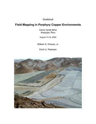
1. Guidebook
Field Mapping in Porphyry Copper Environments
Cerro Verde Mine
Arequipa, Peru
August 13-16, 2000
William X. Chavez, Jr.
Erich U. Petersen
2. Field Mapping in Porphyry Copper Environments
Participants
1. Brooks, William 105525.1436@compuserve.com
2. Carrizales L., Hector, Minera Teck Peru teckgeo@terra.com.pe
3. Tejada L., Walter, Minera Teck Peru teckgeo@terra.com.pe
4. Escobar B., Daniel, Minera Teck Peru teckgeo@terra.com.pe
5. Araya, Erick, Rio Algom Chile exploranto@rioalgom.cl
6. Alva, Roly, AngloGold Peru apardo@anglogold.com.pe
7. Sanchez, Carlos, AngloGold Peru
8. Waddell, Alistair, AngloGold Peru awadell@anglogold.com.pe
9. Palacios, Celso, AngloGold Peru
10. Anyosa, Nazario, AngloGold Peru apardo@anglogold.com.pe
11. Miranda, Juan, AngloGold Peru
12. Riquelme, Santiago, AngloGold Peru
13. Cortes Y., Jaime, Rio Tinto Chile jaimecortes@compuserve.com
14. Carrasco M., Pedro, Rio Tinto Chile rioanto@entelchile.net
15. Salazar S., Percy, Rio Tinto Peru mansa@rtzlima.com.pe
16. Palpan R., Ewald, Rio Tinto Peru mansa@rtzlima.com.pe
17. Paredes C., Angel, Rio Tinto Peru mansa@rtzlima.com.pe
18. Ferreira Espada, Eugenio, Rio Tinto Peru eugenio@rtzlima.com.pe
19. Pritting, Jack, Consultant/BHP Chile jrpritting@hotmail.com
20. Carrera N. Alex, student carreraalfa@hotmail.com
21. Nicolson, Diane, Noranda Peru dnicol@attglobal.net
22. Fava, Luis, Noranda Peru
23. Krischev, Yassen, Rio Tinto Europe yassen_khrischev@yahoo.com
24. Minaya Pastor, Henry, CEDIMIN geologia@cedimin.com.pe
3. Itinerary
13 August, Sunday
6:00 PM Assemble at Hotel Jarusalen
14 August, Monday
6:00 AM Breakfast
7:00 AM Depart from Hotel Jarusalen for Cerro Verde
8:00 AM Check in at Cerro Verde, Mine Safety
9:00 AM Mapping I: Cerro Verde Pit
1:00 PM Lunch
1:30 PM Mapping II: Cerro Verde Pit
5:00 PM Depart Cerro Verde for Hotel
Evening Session
15 August, Tuesday
6:00 AM Breakfast
7:00 AM Depart from Hotel Jarusalen for Cerro Verde
8:00 AM Mapping III: Santa Rosa Pit
12:00 PM Lunch
1:00 PM Mapping IV: Santa Rosa Pit
5:00 PM Depart Cerro Verde for Hotel
Evening Session
16 August, Wednesday
6:00 AM Breakfast
7:00 AM Depart from Hotel Jarusalen for Cerro Verde
8:00 AM Mapping V: Tour of Porphyry copper special features
1:00 PM Lunch
1:30 PM Mapping VI: Cerro Negro Tour
3:30 PM Depart for Airport
4. Acknowledgements
We wish to acknowledge the many individuals and organizations that made this
course possible. We thank Phelps Dodge and Sociedad Minera Cerro Verde S.A.A. for
granting generous access to the Cerro Verde and Santa Rosa deposits. Jim Jones and
David P. Braxton provided invaluable help in organizing the course. The Society of
Economic Geologists sponsored the mapping course.
Erich U. Petersen William X. Chavez, Jr.
Department of Geology and Geophysics Minerals & Environmental Engineering
The University of Utah Department
135 S. 1460 E., Room 719 New Mexico School of Mines
Salt Lake City, UT 84105 Socorro, NM 87801
801-581-7238 505-835-5252
Eupeter@mines.utah.edu wxchavez@nmt.edu
http://www.mines.utah.edu/pyrite
5. Geology of Cerro Verde
Cerro Verde y Santa Rosa, ubicados a 30 km al SO de Arequipa, son yacimientos
del tipo pórfido de cobre y molibdeno, emplazados en el sgmento sur del Batolito de la
Costa, Segmento Arequipa, Superunidades Tiabaya y Yarabamba. Localmente se tiene
rocas plutónicas intruidas por rocas subvolcánicas porfiríticas, volánicas y sedimentarias,
con edades que van desde el Precámbrico hasta el Terciario inferior. Remanentes de
ignimbritas, cenizas y arenas volcánica, corresponden a los últimos eventos ocurridos in
el área.
Las rocas plutónicas que engloban al os pórfidos subvolcánicos, genéticamente
relacionados a los depósitos de cobre porfirítico de Cerro Verde y Santa Rosa, conforman
el complejo intrusivo conocido como "La Caldera", estos pórfidos están alineados según
una dirección NO-SE, que es la misma de la Cordillera de los Andes. Fisiográficamente,
presentan una topografía madura con cerros redondeados de baja altura, quebradas secas
y drenaje dendrítico. Geológicamente estos depósitos se extienden más allá de sus
limites conocidos, tanto lateral como vericalmente, pero económicamente y en términos
operativos comprometen sólo parte de la extensión anterior. Dentro del área de estudio,
los principales tipos de rocas son: gneis, granodiorta, pórfidos de dacita-monzonita y
brechas de cuarzo-tourmalina, curazo-dumotierita y silíceas, estas brechas contienen
fragmentos de distintas litologías antes mencionadas.
El origen de estos depósitos está estrechamente vinculado al emplazamiento de
los stocks porfiríticos dacíticos-monzoníticos, de origen hipabisal. La edad asignada a
estas rocas es de 60 m.a. La alteración hipógena producida por estas intursiones tiene
una dstribución algo simétrica y concéntrica, con una zona potásica al centro, seguida de
una fílica, que es la más difundida y finalmente la propilítica envolviendo casi eteramente
a las anteriores. De forma asimétrica y sólo en algunas partes del depósito se presentan la
alteración argílica avanzada y la silicificación; la primera está muy relacionada con la
6. zona de enriquecimiento supergénico por calcosita y covelita; la mieralización dentro de
la zona de óxidos por brochantita, crisocola, malaquita y "pitch de cobre", pro encima de
estas zonas se encontraba una potente cubierta de minerales lixiviados y limonitas.
El fallamiento premineral sigue la dirección NO-SE del levantamiento Andino,
los cuerpos de pórdidos y brechas se alinean sigiendo esta misma drección; el fallamiento
tensional post-mineral revela una importante componente E-O también los sistemas NO-
SE y NE-SO.
Departamento de Geologia MCVSAA
7.
8. Cerro Verde Rocks
A suite of rocks collected in May 2000 in the Cerro Verde and Santa Rosa open
pits are described below. Many of the rocks were examined petrographically and
analyzed by X-ray diffraction. The plates can also be seen in the Mapping Course
website. The URL is http://www.mines.utah.edu/pyrite/mappingcourse.
Rock Plate A
A CV 0+0: Cerro Verde. Dacite-Monzonite Porphyry cut by hematite veins. All
mafic minerals and feldspars have been altered to white phyllosilicates. See
also Plate 1, A, C (7310027)
B CV 0+25: Cerro Verde. Dacite-Monzonite Porphyry cut by hematite veins.
All mafic minerals and feldspars have been altered to white phyllosilicates.
What criteria can we see in the actual rocks that indicate whether the
precursor mineral to hematite was chalcopyrite or chalcocite? See also Plate
1, B, D (7310026)
C CV 2633B: Cerro Verde. Dacite-Monzonite Porphyry cut by jarosite veins.
All mafic minerals and feldspars have been altered to white phyllosilicates.
All disseminated sulfides have been converted to jarosite. This suggests that
the pyrite was disseminated in the rock and dominated the vein filling. See
also Plate 2, A, B, C (7310025)
D SR Alun: Santa Rosa. Massive, tan-colored alunite vein about 6 cm thick. See
also Plate 2, D (7310023)
Rock Plate B
A SR 208: Santa Rosa. Tourmaline breccia. See also Plate 3, A, B (7310033)
B SR SW B: Santa Rosa. Silicified and pyritized dacite-monzonite porphyry.
See also Plate 3, D (7310032)
C SR 2558: Santa Rosa. "D" vein cuts dacite-monzonite porphyry. Note ~1.5
cm wide silicified halo on pyrite vein. See also Plate 3, C; Plate 4, A, B
(7310034)
D CVS: Cerro Verde. Cerro Verde Schist. Massive phlogopite; folliated. See
also Plate 4, C, D (7310030)
9. Rock Plate C
A BRECCIA: Santa Rosa. Polylithic breccia. Subrounded to angular fragments
range in size from less than 1 cm to over 5 cm. Breccias Silíseas. (8090003)
B BON: Santa Rosa. Chalcopyrite breccia from high-grade 'bonanza' zone.
Breccia fragments contain disseminated chalcopyrite. Chalcopyrite cements
angular breccia fragments. (8090005)
Photomicrographs Plate 1
A CV 0+0: Cerro Verde. Dacite-monzonite porphyry showing leached pyrite
(hematite-lined voids). Minor tourmaline is present throughout the rock. X-
ray diffraction shows that the sample contains considerable kaolinite. PL,
50X, FOV = 2mm (7310027)
C CV 0+0: Cerro Verde. Same as A. Photomicrograph shows that all
groundmass, feldspar and mafic minerals have been altered to white
phyllosilicate. XP, 50X, FOV = 2mm (7310027)
B CV 0+25: Cerro Verde. Dacite-monzonite porphyry showing leached pyrite
(hematite lined voids). Late torumaline occurs along fractures and is also
disseminated throughout the rock. PL, 50X, FOV = 2mm (7310026)
D CV 0+25: Cerro Verde. Same as B. Hematite boxworks after pyrite. PL,
50X, FOV = 2mm (7310026)
Photomicrographs Plate 2
A CV 2633B: Cerro Verde. Dacite-monzonite porphyry showing that all
disseminated precursor sulfides (pyrite) are altered to pale yellow jarosite.
PL, 50X, FOV = 2mm (7310025)
B CV 2633B: Cerro Verde. Same as B. Photomicrograph shows that all
feldspars and mafic mineral have been converted to white phyllosilicate. XP,
50X, FOV = 2mm (7310025)
C CV 2633B: Cerro Verde. 1200-micron wide 'vein' cuts from lower right to
upper left. "Vein" contains fragments of wall rock (microbreccia) in a matrix
of jarosite. Elsewhere, younger jarosite-only veins are developed within this
vein. PL, 50X, FOV = 2mm (7310025)
10. D SR Alun: Santa Rosa. Contact between vein fill and wall rock. Vein fill is
fine-grained (10 x 40 micron) alunite crystals (top right). XP, 50X, FOV =
2mm (7310023)
Photomicrographs Plate 3
A SR 208: Santa Rosa. Three habits of tourmaline are present. A fibrous, light
colored variety; a very coarse, pale-dark green variety that commonly forms
rosettes; and clusters of isolated crystals. Crystals of the latter variety can
range from 80 to 1000 microns but are commonly less than 100 microns long.
The fibrous variety commonly overgrows the coarse variety. The
"groundmass” is coarse mosaic quartz. PL, 50X, FOV = 2mm (7310033)
B SR 208: Santa Rosa. Same as A. XP, 50X, FOV = 2mm (7310033)
C SR 2558: Santa Rosa. Fine-grained quartz, white phyllosilicate and pyrite
(opaque). All the mafic minerals and feldspar have been converted to white
phyllosilicate. XRD shows that quartz, phyllosilicate, kaolinite and pyrite are
present. XP, 50X, FOV = 2mm (7310034)
D SR SW B: Santa Rosa. X-ray confirms that this sample consists of quartz,
white phyllosilicate and pyrite. White phyllosilicate pseudomorphs of
euhedral feldspar can be recognized. This sample is much coarser grained
than SR 2558 and contains no Cu-sulfides as disseminations or 'eggs'. XP,
50X, FOV = 2mm (7310032)
Photomicrographs Plate 4
A SR 2558: Santa Rosa. Vein pyrite showing "eggs" of chalcopyrite, bornite
and bornite-chalcopyrite. RL, 200X, FOV = 0.5mm (7310034)
B SR 2558: Santa Rosa. Disseminated sulfides in sample. Pyrite abundance is
greater than Cu-sulfide abundance. Dark blue is covellite; lighter blue is
chalcocite. Elsewhere covellite replaces chalcopyrite. Replacement by
covellite indicates low copper activity solutions. RL, 200X, FOV = 0.5mm
(7310034)
C CVS: PL, Cerro Verde. This sample has strong folliation that is imparted by
the alignment of pale green trioctahedral phyllosilicate ('phlogopite'). Knots
of chlorite and white phyllosilicate (relic feldspar?) are common. 100X, FOV
= 1mm (7310030)
D CVS: XP, Cerro Verde. Same as C. 100X, FOV = 1mm (7310030)
28. Useful References
Titley, S.R., Ed., 1982, Advances in Geology of the Porphyry Copper Deposits,
Southwestern North America. University of Arizona Press, Tucson, AZ, 560 p.
Titley, S.R. and Hicks, C.L., Eds., 1966, Geology of the Porphyry Copper Deposits,
Southwestern North America, University of Arizona Press, Tucson, AZ, 287 p.
Compton, R.R., 1985, Geology in the Field. John Wiley and Sons, New York, 398 p.
Billings, M.P., 1972, Structural Geology, third edition, Prentice Hall, New York, 606 p.
Davis, G.H., 1984, Structural Geology of Rocks and Regions. John Wiley and Sons, New
York, 492 p.
Pierce, F.W and Bolm, J.G., Eds., 1995, Porphyry Copper Deposits of the American
Cordillera. Arizona Geological Society Digest 20, 656 p.
Chávez. W.X., Jr., 2000, Supergene Oxidation of Copper Deposits: Zoning and
Distribution of Copper Oxide Minerals. SEG Newsletter No. 41, April 2000.
Phelps Dodge, 2000, Geologia de los Porfidos de Cobre Cerro Verde Y Santa Rosa,
Arequipa, Peru. Departamento de Geologia, 21 p.