Reality Crash. 64-bit architecture, Manejo avanzado de nubes de puntos del láser escáner Focus3D o Freestyle3D, herramienta momentum análisis, y gráficos avanzados. Puede soportar hasta 2 billones de datos de nubes de puntos
The presenter discusses 3D scanning technologies including terrestrial scanning using tripod-mounted scanners, handheld scanning, and drone-based scanning. Some applications of 3D scanning mentioned are orthophoto generation, 3D scans in the cloud, virtual reality, generating orthomosaics and point clouds from drone data, and 3D modeling. Examples are given of multimedia visualizations and commercial videos produced using drone-scanned data.
Empowering Photogrammetry and 3D workflows with SURE SoftwareJohn Stewart III
nFrames empowers business to create new use cases with a modular and customisable photogrammetry workflow. Create True Orthophotos, Dense Point Clouds and Scalable Meshes fully automatically. Learn more at www.nframes.com
This document provides an overview of the Map component in Necto 16, including how to access and use the Map component, its key properties and functions, and the Map Designer tool. The Map component allows geospatial and hierarchical data to be visualized on base maps and templates for analysis. It is accessed from the Design ribbon and requires at least one geographic dimension. Properties include selecting dimensions, the basemap, template, and zooming functionality. The optional Map Designer further customizes maps.
Seasoned San Diego-based entrepreneur Alex Hern’s foci include incubating and funding technology enterprises. Moreover, Alex Hern serves as the CEO of Tsunami XR, Inc., a digital workspace platform that enables the seamless collaboration of team members via extended reality (XR).
This document summarizes a presentation given on implicit surface modeling for 3D printing using signed distance fields and raymarching. The presentation discusses how signed distance fields can implicitly define 3D volumes and shapes using mathematical functions. It also explains how raymarching can be used to render these implicit surfaces in real-time and how marching cubes can extract triangle meshes from the signed distance fields to output 3D models that can be 3D printed. Benefits of this approach for 3D printing discussed include producing unbreakable surfaces, perfect volume definitions, and enabling cheap deformations, blending, shelling, soft shadows and reflections for generated models. The presentation concludes with a live demo of dynamically modifying a signed distance field to tweak a
AR Foundation framework: product roadmap – Unite Copenhagen 2019Unity Technologies
Learn about the latest developments in AR Foundation, the Unity framework purpose-built for augmented reality (AR) development that lets you build your app once and deploy across mobile and wearable AR platforms. In this session you'll also hear about the roadmap for AR Foundation and what's in the works.
Speakers:
Mike Durand – Unity
Matt Fuad – Unity
Watch the session on YouTube: https://youtu.be/UkBXOff8Efo
This document summarizes information about Pix4D, a company that develops mapping software using UAV/drone imagery. Pix4D was founded in 2011, is based in Lausanne, Switzerland and has 40 employees. The document discusses Pix4D's use of different camera lenses, including fisheye lenses, for drone mapping. It also covers topics like the relationship between data acquisition/processing costs and model accuracy, and automated image processing workflows in Pix4D software.
In the summer of 2014 ScanLAB Projects worked with director Giles
Revell, post production house The Mill and advertising agency AMV
BBDO to create Transparent a short educational campaign video to
warn against the dangers of rural roads. The work collects a series of
rural locations to build up a virtual film set, in which the fateful story of a
road accident unfolds.
SCENE software processes and manages 3D scan data from FARO laser scanners through automatic object recognition, scan registration, and positioning. It provides tools for visualization, measurement, meshing, and exporting point cloud and CAD formats. SCENE WebShare Cloud is a cloud-based service that allows for convenient and secure sharing of scan project data and worldwide collaboration.
3D laser scanning technology allows for the rapid and accurate capture of spatial data in three dimensions. International Partner Buro S.R.L. uses this technology to provide 3D point clouds, models, panoramic views, and other products to clients in industries such as oil and gas. The laser scanning process generates detailed spatial data that can be used for applications like monitoring infrastructure, volume calculations, and facilitating project planning and maintenance.
Desktop Softwares for Unmanned Aerial Systems(UAS))Kamal Shahi
The document compares various desktop software used for processing data from unmanned aerial vehicles (UAVs). It provides a table comparing the major features and functionality of Pix4Dmapper, Agisoft Metashape, WebODM, and QGIS. These include outputs generated, ease of use, cost, support and limitations. It also provides guidance on choosing the best software by defining needs, researching options, trying demonstrations, considering costs, and getting recommendations from experts. Selecting the right software depends on the required processing capabilities, accuracy, compatibility and other factors listed.
Augmented Reality Tutorial dedicated to Computational Fluid DynamicsMarco Losurdo
Augmented Reality Tutorial dedicated to Numerical Simulations Rendering.
How to augment scientific results to visualize them on smart devices (smartphone, tablets and including 3D Glasses like moverio bt200 and hololens).
Cooperation with www.fetchcfd.com, www.terrasame.com for computational support and hololens visualization.
The 2016 Remote Sensing Field camp will take the form of two projects.
A low tech, low cost aerial photography project using visible spectrum UAV/Ultralight Aircraft mounted cameras as the sensor to demonstrate that relatively low tech, low cost solutions can achieve surprisingly good results when compared to more commercial systems.
A more high tech, high cost terrestrial LiDAR collect of a building or structure of historical or architectural significance.
The scope of a project will influence all other aspects of the project, including its cost, timing, quality and risk.
CD Spring 2018 - Reality Modelling into Operational Training (Track Access)Comit Projects Ltd
Track Access Services Ltd provides digital services for rail, including reality modelling using video, laser scanning, and 3D modelling. They capture driver's eye video and positional data to create interactive models for route familiarization, signal sighting, and reviewing design changes. By integrating video, point clouds, and CAD data, their models provide visual context to help evaluate designs and make decisions without site visits. The accurate 3D models are used for engineering, simulation and training to reduce the need for building multiple versions.
This document discusses using the Microsoft Kinect for 3-D mapping of rooms. It describes how the Kinect uses an infrared sensor and RGB camera to create depth images and produce 3D point clouds of environments. The document outlines how SLAM algorithms can then be used to extract visual keypoints from images to localize points in 3D space and build consistent maps over time as the Kinect moves. These maps could be used for robot navigation or teleoperation. The Kinect is presented as a low-cost alternative to more expensive depth sensing systems.
Topo Planner tool is designed to specifically meet the needs of engineers, architects and designers using Autodesk or Bricsys products. Using the easy-to-use, wizard-driven interface, you can import georeferenced raster imagery directly from your favorite mapping server (Google, Bing, ESRI…) into the AutoCAD or BricsCAD drawing.
Icaros Photogrammetric Suite (IPS) Module OverviewIcarosMapping
Product Overview - Icaros Photogrammetric Suite (IPS) of software. Includes descriptions of each module of IPS, to include aerial triangulation, elevation extraction, orthoproduction, and advanced editing tools.
Customizable Embedded 3D Surround View Turn-Key Solution on Apalis iMX6 SoMToradex
Toradex's partner TES Electronic Solutions GmbH presents a customizable 3D Surround View Turn-Key solution based on the Toradex Apalis iMX6 SoM that can be quickly adapted concerning the specific requirements of the targeted vehicle. Read more in their guest blog post here: https://www.toradex.com/blog/customizable-embedded-3d-surround-view-turn-key-solution-apalis-imx6-som
MAXON CINEMA 4D RELEASE 17 AVAILABLE NOW!
Powerful new features like the Take System, optimized motion tracking, completely reworked spline tools and connectivity to the Houdini Engine will be presented at the IBC 2015 in Amsterdam.
Friedrichsdorf, 2. September 2015: Today MAXON announces the immediate availability of Cinema 4D Release 17 (R17), the newest version of its leading 3D software solution for motion graphics, visual effects, visualization and rendering. With outstanding new features for modeling, sculpting, animation and rendering, this new release will help users achieve an even more efficient workflow. The new Take System offers functions above and beyond those of any conventional render layer system and the Houdini Engine connectivity, the versatile Color Chooser and updated import and export functions with new data exchange features all combine to dramatically increase production pipeline performance. Innovative sculpting functions, expanded motion tracking features and completely reworked spline tools enhance the design process for modeling, sculpting and animation for even better results.
What is #PointCloudAnnotation? It is creating better data models for #MachineLearning algorithms!!
Read more at: https://annotationsupport.com/blog/what-is-point-cloud-annotation/
Simulation for autonomous driving at uber atgYu Huang
Testing Safety of SDVs by Simulating Perception and Prediction
LiDARsim: Realistic LiDAR Simulation by Leveraging the Real World
Recovering and Simulating Pedestrians in the Wild
S3: Neural Shape, Skeleton, and Skinning Fields for 3D Human Modeling
SceneGen: Learning to Generate Realistic Traffic Scenes
TrafficSim: Learning to Simulate Realistic Multi-Agent Behaviors
GeoSim: Realistic Video Simulation via Geometry-Aware Composition for Self-Driving
AdvSim: Generating Safety-Critical Scenarios for Self-Driving Vehicles
Appendix: (Waymo)
SurfelGAN: Synthesizing Realistic Sensor Data for Autonomous Driving
Augmented Reality Application - Final Year ProjectYash Kaushik
The document is a project report on augmented reality. It discusses the history and types of augmented reality, including marker-based and markerless augmented reality. It describes an augmented reality app called AmiMap developed by the student for their final year project. The app uses markers to trigger augmented reality content like maps. The report discusses the software, portals and process used to develop the app in Unity and deploy it on Android. It also talks about some problems faced and solutions explored for augmented reality development.
For the full video of this presentation, please visit:
http://www.embedded-vision.com/platinum-members/qualcomm/embedded-vision-training/videos/pages/may-2016-embedded-vision-summit-mangen
For more information about embedded vision, please visit:
http://www.embedded-vision.com
Michael Mangen, Product Manager for Camera and Computer Vision at Qualcomm, presents the "High-resolution 3D Reconstruction on a Mobile Processor" tutorial at the May 2016 Embedded Vision Summit.
Computer vision has come a long way. Use cases that were previously not possible in mass-market devices are now more accessible thanks to advances in depth sensors and mobile processors. In this presentation, Mangen provides an overview of how we are able to implement high-resolution 3D reconstruction – a capability typically requiring cloud/server processing – on a mobile processor. This is an exciting example of how new sensor technology and advanced mobile processors are bringing computer vision capabilities to broader markets.
The document describes a parking space counter project developed by a team of 4 students under the guidance of Mrs. Sujakumari N R. The project utilizes Python and OpenCV to create an automated system for counting available parking spaces in real-time by analyzing video feeds and detecting vehicles. The system is intended to improve parking management and enhance user experience by providing accurate information on parking availability. Key modules included video acquisition, vehicle detection and tracking, occupancy analysis and counting, and a user interface to display results.
IRJET- Proposed Design for 3D Map Generation using UAVIRJET Journal
The document proposes a design for 3D map generation using an unmanned aerial vehicle (UAV). Images collected by the UAV would undergo processing using techniques like photogrammetry and videogrammetry to generate point clouds and convert the 2D images into 3D models. Pix4Dmapper software would be used to analyze control points within images, overlap similar images, filter out noise, and generate the 3D point cloud which forms the basic building block for 3D map creation. The vSLAM algorithm would also be used to determine the sensor orientation and reconstruct the environment. The proposed system would use tools like the Tower app and databases like MySQL and HBase to control the UAV, process and store the image data,
JRLA was tasked with analyzing why a freight car failed to be derailed when it broke loose. Traditional measurement methods could not capture the complex shapes of the derail shoe and wheels accurately. JRLA used a FARO laser scanner to create 3D models, allowing analysis in a 3D environment. This showed the derail shoe was placed incorrectly, leaving the top of the rail exposed. When wheels rolled over it, the first re-railed itself past the shoe. The second then pushed the shoe off the rail completely. The laser scanning improved JRLA's services and reduced measurement time by over 75% compared to traditional methods.
Reporte de desgaste en molinos para mina de cobreUlises Uscanga
ANÁLISIS DE DESGASTE Y DIMENSIONES EN MOLINO SAG
El hacer un analisis de forma tradicional para el remplazo de los liners de un molino de este tipo que genera millones de dolares, tenia unos costos muy altos para la industria al detenerlo para su inspeccion por varios dias. La solucion de FARO y 3DSystems fue la solucion ideal, ya que una inspeccion con el Focus3D se realiza en solo unas horas, ahorrandole a la mina millones de dolares.
The document discusses the use of 3D laser scanning with the FARO Focus3D for documenting cultural heritage sites. It provides examples of how the Focus3D has been used to digitally preserve cave paintings in Somalia, document an underground temple discovery in Barcelona during construction works, and scan the complex architecture of Mont Saint Michel Abbey in France. The Focus3D allows quick, accurate, and non-invasive 3D recording of cultural sites and objects, creating digital models and data that can be used for preservation, research, and visualization projects.
1) Tilden-Coil Constructors, a construction company in Southern California, adopted 3D laser scanning technologies like the FARO Focus3D X130 scanner to help solve problems, identify issues early, and save costs on their projects.
2) Scanning existing conditions and overlaying the point clouds on 3D models allows Tilden-Coil to find and resolve conflicts before they cause delays or become more expensive to fix. On one project, scanning identified that concrete slabs were poured too high, avoiding blaming the wrong subcontractors.
3) Scanning reinforced concrete walls and floors before pouring allows Tilden-Coil to coordinate openings for pipes and conduits to avoid
This document outlines 9 best practices for using laser scanning effectively in construction projects based on JE Dunn Construction's experience with 1,450 hours of laser scanning. The best practices are: 1) Identify how scan data will be used; 2) Educate clients on laser scanning limitations; 3) Understand the physical space; 4) Know the project scope; 5) Determine required deliverables; 6) Establish survey control first; 7) Collect more data than needed; 8) Assess time to deliver; 9) Use a dedicated, experienced scanning team. When followed, these practices help maximize the value of laser scanning.
Surveying / As-built documentation The challenging survey of a material handling project covering 6,000 m2 over two floors was successfully
completed by a FARO Laser Scanner.
The document discusses common issues with traditional survey methods for capturing plant documentation including outdated or inaccurate documentation, inconsistent manual measurements, and missed measurements requiring repeated trips to the field. It also mentions safety and risk mitigation concerns from climbing equipment in dangerous conditions for extended periods. Traditional survey methods also require more manpower on-site for longer times, resulting in longer plant shutdowns during turnarounds.
Este documento proporciona información sobre el uso de la tecnología de escaneado láser 3D para la documentación de plantas industriales. Explica que el escáner láser FARO Focus3D puede utilizarse para supervisar proyectos de construcción, crear modelos digitales de plantas, gestionar activos, documentar renovaciones y cumplir con normativas de seguridad. El escáner ofrece numerosas ventajas como una documentación precisa, reducción de riesgos y costos, y mejor colaboración entre partes involucradas.
Reporte de evaluacion de tanques 3D Systems + FAROUlises Uscanga
Evaluación de Tanques – Calculo de Volumen, Desgaste y Tolerancias Geométricas.
Nueva Solución de Levantamiento Digital + Software especializado (1 día) Una solución innovadora para la difícil tarea de medición y certificación de volumen, Redondez, Verticalidad, Paralelismo
Evaluación de desgaste entre otros de tanques de almacenamiento.
Genocide in International Criminal Law.pptxMasoudZamani13
Excited to share insights from my recent presentation on genocide! 💡 In light of ongoing debates, it's crucial to delve into the nuances of this grave crime.
Business law for the students of undergraduate level. The presentation contains the summary of all the chapters under the syllabus of State University, Contract Act, Sale of Goods Act, Negotiable Instrument Act, Partnership Act, Limited Liability Act, Consumer Protection Act.
सुप्रीम कोर्ट ने यह भी माना था कि मजिस्ट्रेट का यह कर्तव्य है कि वह सुनिश्चित करे कि अधिकारी पीएमएलए के तहत निर्धारित प्रक्रिया के साथ-साथ संवैधानिक सुरक्षा उपायों का भी उचित रूप से पालन करें।
Integrating Advocacy and Legal Tactics to Tackle Online Consumer Complaintsseoglobal20
Our company bridges the gap between registered users and experienced advocates, offering a user-friendly online platform for seamless interaction. This platform empowers users to voice their grievances, particularly regarding online consumer issues. We streamline support by utilizing our team of expert advocates to provide consultancy services and initiate appropriate legal actions.
Our Online Consumer Legal Forum offers comprehensive guidance to individuals and businesses facing consumer complaints. With a dedicated team, round-the-clock support, and efficient complaint management, we are the preferred solution for addressing consumer grievances.
Our intuitive online interface allows individuals to register complaints, seek legal advice, and pursue justice conveniently. Users can submit complaints via mobile devices and send legal notices to companies directly through our portal.
The Future of Criminal Defense Lawyer in India.pdfveteranlegal
https://veteranlegal.in/defense-lawyer-in-india/ | Criminal defense Lawyer in India has always been a vital aspect of the country's legal system. As defenders of justice, criminal Defense Lawyer play a critical role in ensuring that individuals accused of crimes receive a fair trial and that their constitutional rights are protected. As India evolves socially, economically, and technologically, the role and future of criminal Defense Lawyer are also undergoing significant changes. This comprehensive blog explores the current landscape, challenges, technological advancements, and prospects for criminal Defense Lawyer in India.
Corporate Governance : Scope and Legal Frameworkdevaki57
CORPORATE GOVERNANCE
MEANING
Corporate Governance refers to the way in which companies are governed and to what purpose. It identifies who has power and accountability, and who makes decisions. It is, in essence, a toolkit that enables management and the board to deal more effectively with the challenges of running a company.
Receivership and liquidation Accounts
Being a Paper Presented at Business Recovery and Insolvency Practitioners Association of Nigeria (BRIPAN) on Friday, August 18, 2023.
Sangyun Lee, 'Why Korea's Merger Control Occasionally Fails: A Public Choice ...Sangyun Lee
Presentation slides for a session held on June 4, 2024, at Kyoto University. This presentation is based on the presenter’s recent paper, coauthored with Hwang Lee, Professor, Korea University, with the same title, published in the Journal of Business Administration & Law, Volume 34, No. 2 (April 2024). The paper, written in Korean, is available at <https://shorturl.at/GCWcI>.
Sangyun Lee, 'Why Korea's Merger Control Occasionally Fails: A Public Choice ...
FARO Reality techsheet
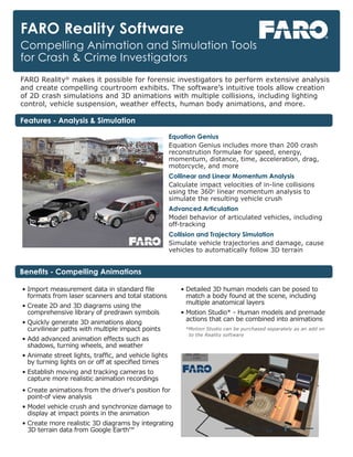
1. FARO Reality Software
Compelling Animation and Simulation Tools
for Crash & Crime Investigators
• Import measurement data in standard file
formats from laser scanners and total stations
• Create 2D and 3D diagrams using the
comprehensive library of predrawn symbols
• Quickly generate 3D animations along
curvilinear paths with multiple impact points
• Add advanced animation effects such as
shadows, turning wheels, and weather
• Animate street lights, traffic, and vehicle lights
by turning lights on or off at specified times
• Establish moving and tracking cameras to
capture more realistic animation recordings
• Create animations from the driver‘s position for
point-of view analysis
• Model vehicle crush and synchronize damage to
display at impact points in the animation
• Create more realistic 3D diagrams by integrating
3D terrain data from Google Earth™
• Detailed 3D human models can be posed to
match a body found at the scene, including
multiple anatomical layers
• Motion Studio* - Human models and premade
actions that can be combined into animations
*Motion Studio can be purchased separately as an add on
to the Reality software
FARO Reality®
makes it possible for forensic investigators to perform extensive analysis
and create compelling courtroom exhibits. The software’s intuitive tools allow creation
of 2D crash simulations and 3D animations with multiple collisions, including lighting
control, vehicle suspension, weather effects, human body animations, and more.
Equation Genius
Equation Genius includes more than 200 crash
reconstrution formulae for speed, energy,
momentum, distance, time, acceleration, drag,
motorcycle, and more
Collinear and Linear Momentum Analysis
Calculate impact velocities of in-line collisions
using the 360o
linear momentum analysis to
simulate the resulting vehicle crush
Advanced Articulation
Model behavior of articulated vehicles, including
off-tracking
Collision and Trajectory Simulation
Simulate vehicle trajectories and damage, cause
vehicles to automatically follow 3D terrain
Benefits - Compelling Animations
Features - Analysis & Simulation