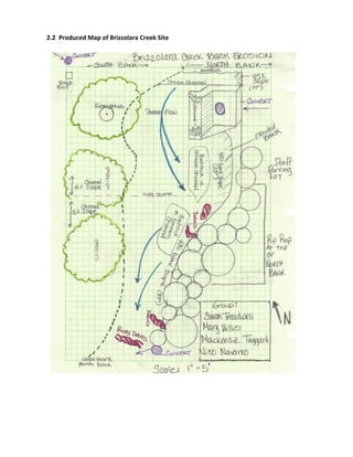
Erosion	
  and	
  Sediment	
  Control	
  Plan	
  
Brizzolara	
  Creek	


MNMS	
  Erosion	
  Consultants	
  	
  
1	
  Grand	
  Avenue	
  
San	
  Luis	
  Obispo,	
  CA	
  93410	


Mary	
  Hillis	
  	
  mehillis@calpoly.edu	
  
Nico	
  Navarro	
  	
  nrnavarr@calpoly.edu	
  
Mackenzie	
  Taggart	
  	
  mtaggart@calpoly.edu	
  
Sarah	
  Treadwell	
  	
  streadwe@calpoly.edu	


Table	
  of	
  Contents	


1. Introduction	
  
1. Introduction	
  to	
  Brizzolara	
  Creek	
  Erosion	
  &	
  Sediment	
  Control	
  Plan	
  
2. Goals	
  and	
  Objectives	
  	
  
3. Regulatory	
  Requirements	
  of	
  the	
  Proposed	
  Project	


2. Site	
  Assessment	
  	
  
1. Aerial	
  Map	
  of	
  Brizzolara	
  Creek	
  Site	
  
2. Produced	
  Map	
  of	
  Brizzolara	
  Creek	
  Site	
  Depicting	
  Project	
  Plans	
  
3. Site	
  Description	
  	
  
1. Soils,	
  Vegetation,	
  Landscape	
  
2. Sources	
  of	
  water	
  and	
  sediment	
  
3. Site	
  Measurements	
  
4. Evaluation	
  of	
  erosion	


3. Erosion	
  and	
  Sediment	
  Control:	
  Best	
  Management	
  Practices	
  	
  
1. J-­‐Hook	
  
2. Riprap	
  
3. Erosion	
  Control	
  Netting	
  
4. Bioretention	
  Planters	


4. Maintenance	
  and	
  Inspection	
  Procedures	
  For	
  Project	
  	
  
1. Schedule	
  of	
  procedures	
  and	
  planned	
  inspections	
  
2. Description	
  of	
  Maintenance:	
  J-­‐Hook	
  
3. Description	
  of	
  Maintenance:	
  Riprap	
  
4. Description	
  of	
  Maintenance:	
  Erosion	
  Control	
  Netting	
  
5. Description	
  of	
  Maintenance:	
  Bioretention	
  Planters	


5. Certifications	
  and	
  Notifications	


6. Conclusion	


7. References	


1. 	
  Introduction	


1.1 	
  	
  Introduction	
  To	
  Brizzolara	
  Creek	
  
The	
  purpose	
  of	
  this	
  project	
  is	
  to	
  mitigate	
  channel	
  erosion	
  at	
  the	
  stream	
  meander	
  north	
  of	
  
Engineering	
  IV	
  building	
  on	
  the	
  California	
  Polytechnic	
  State	
  University	
  San	
  Luis	
  Obispo,	
  CA.	
  	
  The	
  
outer	
  bank	
  of	
  the	
  stream	
  meander	
  has	
  been	
  laterally	
  eroded,	
  leaving	
  unstable	
  slopes	
  that	
  
threaten	
  the	
  adjacent	
  faculty	
  parking	
  lot	
  and	
  the	
  overall	
  channel	
  health.	
  	
  In	
  addition	
  to	
  the	
  lateral	
  
erosion,	
  additional	
  problems	
  exist	
  that	
  are	
  a	
  detriment	
  to	
  the	
  channel	
  health.	
  	
  The	
  main	
  channel	
  
problems	
  include:	
  
• Lateral	
  erosion	
  of	
  outer	
  bank	
  
• Sedimentation	
  
• Destruction	
  of	
  aquatic	
  habitat	
  and	
  terrestrial	
  vegetation	
  
• Metal	
  scrap	
  waste	
  embedded	
  in	
  outer	
  bank	
  
1.2 Goals	
  &	
  Objectives	
  
This	
  project	
  will	
  focus	
  on:	
  	
  
• Stabilize	
  the	
  eroding	
  outer	
  bank	
  
• Centralize	
  stream	
  flow	
  
• Remove	
  scrap	
  metal	
  along	
  stream	
  bed	
  and	
  outer	
  bank	
  
• Improve	
  overall	
  quality	
  of	
  channel	


1.3 Regulatory	
  Requirements	
  of	
  Proposed	
  Project	
  	
  
There	
  are	
  three	
  main	
  agencies	
  that	
  have	
  jurisdiction	
  over	
  amendments	
  made	
  in	
  Brizzolara	
  Creek.	
  
These	
  agencies	
  and	
  their	
  jurisdiction	
  are	
  explained	
  below.	


California	
  Department	
  of	
  Fish	
  and	
  Wildlife	
  (CDFW):	
  It	
  is	
  necessary	
  to	
  notify	
  the	
  (CDFW	
  before	
  
undergoing	
  streambed	
  alteration.	
  	
  Under	
  the	
  Fish	
  and	
  Game	
  Code	
  1602,	
  it	
  is	
  necessary	
  to	
  notify	
  
the	
  CDFW	
  if	
  any	
  alterations	
  are	
  made	
  to	
  a	
  stream.	
  	
  After	
  notifying	
  the	
  CDFW,	
  a	
  Streambed	
  
Alteration	
  Agreement	
  must	
  be	
  made	
  to	
  permit	
  activity.	
  	
  The	
  agreement	
  process	
  in	
  with	
  the	
  CDFW	
  
must	
  comply	
  with	
  the	
  California	
  Environmental	
  Quality	
  Act	
  (CEQA).	
  	
  The	
  lead	
  agency	
  (local	
  or	
  
state	
  agency	
  with	
  approving	
  authority),	
  which	
  can	
  be	
  the	
  CDFW,	
  must	
  make	
  sure	
  the	
  alteration	
  
complies	
  with	
  the	
  CEQA.	
  	
  Aside	
  from	
  contacting	
  the	
  CDFW	
  it	
  is	
  also	
  important	
  to	
  determine	
  of	
  
local	
  permits	
  are	
  necessary	
  and	
  if	
  the	
  project	
  is	
  under	
  the	
  jurisdiction	
  of	
  federal	
  and	
  state	
  
agencies	
  (CDFW,	
  2014).	


US	
  Army	
  Corps	
  of	
  Engineers	
  (USACE):	
  In	
  the	
  case	
  of	
  of	
  stream	
  alteration	
  the	
  movement	
  of	
  
materials	
  within	
  the	
  streambed	
  requires	
  a	
  USACE	
  404	
  Nationwide	
  Permit	
  (VCPD,	
  2006).	
  	
  This	
  
permit	
  falls	
  under	
  section	
  404	
  of	
  the	
  Clean	
  Water	
  Act	
  (CWA),	
  which	
  regulates	
  discharge	
  of	
  
dredged	
  or	
  fill	
  material	
  into	
  the	
  water	
  of	
  the	
  US	
  (EPA,	
  2014).	
  
Regional	
  Water	
  Quality	
  Control	
  Board	
  (RWQCB)	
  :	
  A	
  401	
  Certification	
  from	
  the	
  RWQCB	
  is	
  
necessary	
  when	
  obtaining	
  a	
  USACE	
  404	
  Permit.	
  	
  This	
  permit	
  falls	
  under	
  section	
  401	
  of	
  the	
  CWA	
  
which	
  declares	
  that	
  each	
  state	
  must	
  certify	
  that	
  the	
  federally	
  permitted	
  activities	
  (in	
  this	
  case	
  
issued	
  from	
  the	
  USACE)	
  are	
  in	
  compliance	
  with	
  all	
  state	
  water	
  quality	
  standards	
  (VCPD,	
  2006).	


2. 	
  Site	
  Assessment	


2.1 Aerial	
  Map	
  of	
  Brizzolara	
  Creek	
  Site	


Brizzolara	
  Creek	
  
Project	
  Site	
  
2.2 Produced	
  Map	
  of	
  Brizzolara	
  Creek	
  Site	


2.3 Site	
  Description	
  	
  
The	
  Brizzolara	
  creek	
  site	
  is	
  located	
  northeast	
  of	
  the	
  California	
  Blvd	
  and	
  Highland	
  Dr	
  intersection	
  
on	
  the	
  Cal	
  Poly	
  campus.	
  The	
  vegetation	
  includes	
  mainly	
  willows	
  and	
  eucalyptus	
  trees	
  with	
  some	
  
herbaceous	
  vegetation	
  sprouting	
  along	
  the	
  streambed	
  and	
  higher	
  up	
  on	
  the	
  banks.	
  The	
  
streambed	
  along	
  the	
  northern	
  segment	
  of	
  the	
  site	
  is	
  exposed	
  bedrock,	
  while	
  the	
  southern	
  section	
  
consists	
  of	
  mainly	
  cobbles	
  three	
  to	
  five	
  inches	
  in	
  width.	
  The	
  creek	
  is	
  currently	
  dry,	
  however	
  runoff	
  
from	
  previous	
  events	
  has	
  caused	
  significant	
  erosion	
  on	
  the	
  outer	
  edge	
  of	
  the	
  stream	
  meander,	
  
along	
  the	
  northern	
  bank.	
  This	
  past	
  erosion	
  is	
  evident	
  through	
  the	
  steep	
  and	
  mostly	
  unvegetated	
  
northern	
  slope	
  adjacent	
  to	
  Highland	
  Dr.	
  In	
  addition,	
  there	
  is	
  a	
  high	
  percentage	
  debris	
  embedded	
  
in	
  the	
  northern	
  bank	
  of	
  the	
  stream	
  channel.	
  The	
  southern	
  bank,	
  which	
  represents	
  the	
  inside	
  of	
  
the	
  meander,	
  displays	
  a	
  significantly	
  lower	
  relief	
  than	
  the	
  northern	
  slope	
  and	
  is	
  highly	
  vegetated.	


2.3.1	
  	
  	
  Description	
  of	
  Soils	
  and	
  Vegetation	
  	
  
The	
  soils	
  at	
  the	
  Brizzolara	
  Creek	
  site	
  are	
  classified	
  as	
  silty	
  clay	
  loam,	
  and	
  are	
  part	
  of	
  the	
  Salinas	
  
soil	
  series.	
  These	
  soils	
  formed	
  from	
  alluvial	
  parent	
  material	
  deposits	
  from	
  weathered	
  
sedimentary	
  rock.	
  The	
  soil	
  is	
  well	
  drained	
  thanks	
  to	
  its	
  composition	
  and	
  is	
  part	
  of	
  hydrologic	
  soil	
  
group	
  C.	
  The	
  K-­‐factor	
  for	
  this	
  soil	
  is	
  .32;	
  this	
  is	
  a	
  relatively	
  high	
  soil	
  erodibility	
  factor	
  and	
  is	
  due	
  
to	
  the	
  high	
  content	
  of	
  silt,	
  which	
  is	
  easily	
  eroded.	
  The	
  average	
  annual	
  temperature	
  in	
  this	
  area	
  
is	
  68-­‐70	
  degrees	
  Farenheit	
  and	
  the	
  average	
  annual	
  precipitation	
  is	
  around	
  23.45	
  inches	


2.3.2	


  Sources	
  of	
  Water	
  and	
  Sediment	
  	
  
There	
  are	
  three	
  main	
  culverts	
  that	
  drain	
  into	
  Brizzolara	
  Creek	
  site	
  within	
  the	
  designated	
  project	
  
area.	
  These	
  culverts	
  supply	
  water	
  runoff	
  and	
  sediment	
  from:	
  an	
  unpaved	
  road	
  running	
  
alongside	
  the	
  creek	
  upland	
  from	
  the	
  southern	
  bank,	
  roof	
  drainage	
  from	
  engineering	
  building	
  
192,	
  and	
  the	
  parking	
  lot	
  adjacent	
  to	
  the	
  creek.	
  These	
  culverts	
  funnel	
  sediment	
  and	
  debris	
  from	
  
the	
  three	
  sources	
  straight	
  into	
  the	
  creek,	
  and	
  pose	
  a	
  problem	
  for	
  the	
  sensitive	
  habitats	
  of	
  
Stenner	
  and	
  other	
  San	
  Luis	
  Obispo	
  creeks	
  downstream	
  of	
  Brizzolara.	
  Runoff	
  and	
  discharge	
  from	
  
the	
  Horse	
  Canyon	
  Watershed	
  also	
  contribute	
  to	
  the	
  water	
  and	
  sediment	
  levels	
  of	
  Brizzoalra	
  
Creek.	


2.3.3	
  	
  	
  Measurements	
  of	
  Site	
  	
  
The	
  designated	
  watershed	
  area	
  contributing	
  runoff	
  and	
  erosion	
  at	
  the	
  Brizzolara	
  Creek	
  site	
  is	
  
approximately	
  3.2	
  square	
  miles.	
  The	
  measured	
  streambed	
  length	
  at	
  the	
  project	
  site	
  is	
  49	
  feet.	
  
The	
  average	
  width	
  of	
  the	
  streambed	
  is	
  10.5	
  feet,	
  and	
  the	
  average	
  depth	
  of	
  the	
  channel	
  is	
  6.5	
  
feet,	
  yielding	
  a	
  cross	
  sectional	
  area	
  of	
  68.3	
  square	
  feet.	


2.3.4	


  Evaluation	
  of	
  Erosion	
  and	
  Sediment	
  Delivery	
  	
  
Field	
  measurements	
  of	
  features	
  were	
  taken	
  at	
  the	
  project	
  site	
  and	
  used	
  to	
  calculate	
  BEHI	
  and	
  
Shear	
  Stress	
  ratings.	
  The	
  bank	
  erosion	
  rate	
  for	
  current	
  and	
  future	
  conditions	
  was	
  then	
  
calculated	
  based	
  on	
  these	
  ratings:	


Current	
  Condition:	
  Brizzolara	
  Creek	
  is	
  currently	
  eroding	
  on	
  the	
  northern	
  slope	
  of	
  the	
  channel.	
  
This	
  slope	
  exhibits	
  a	
  steep	
  grade,	
  a	
  low	
  percentage	
  of	
  surface	
  protection,	
  and	
  a	
  shallow	
  rooting	
  
depth	
  for	
  vegetation.	
  Based	
  on	
  these	
  observations	
  and	
  an	
  assessment	
  of	
  bank	
  materials,	
  the	
  
initial	
  BEHI	
  calculation	
  resulted	
  in	
  an	
  “extreme”	
  rating	
  for	
  the	
  hazard	
  of	
  bank	
  erosion.	
  Similarly,	
  
the	
  initial	
  rating	
  for	
  Shear	
  Stress	
  also	
  resulted	
  in	
  an	
  “extreme”	
  rating.	
  Based	
  on	
  both	
  the	
  initial	
  
ratings,	
  the	
  determined	
  bank	
  erosion	
  rate	
  is	
  2.8	
  ft/yr.	


Future	
  Condition	
  Without	
  BMP’s:	
  When	
  calculating	
  the	
  predicted	
  future	
  BEHI	
  and	
  Shear	
  Stress	
  
ratings	
  for	
  the	
  area	
  of	
  interest,	
  it	
  was	
  determined	
  that	
  most	
  of	
  the	
  channel	
  conditions	
  would	
  
remain	
  constant.	
  	
  The	
  foreseeable	
  changes	
  are	
  a	
  higher	
  relief	
  on	
  the	
  northern	
  slope	
  as	
  it	
  
continues	
  to	
  be	
  affected	
  by	
  lateral	
  scour	
  	
  	
  and	
  a	
  smaller	
  a	
  decrease	
  in	
  surface	
  cover.	
  Based	
  on	
  
these	
  conclusions,	
  the	
  BEHI	
  and	
  Shear	
  Stress	
  ratings	
  the	
  are	
  also	
  rated	
  “extreme”.	
  	
  The	
  
continually	
  degrading	
  conditions	
  result	
  in	
  a	
  slightly	
  higher	
  bank	
  erosion	
  rate	
  of	
  2.9	
  ft/yr.	


Future	
  Condition	
  With	
  BMP’s:	
  The	
  proper	
  installation	
  of	
  Best	
  Management	
  Practices	
  (BMP)	
  will	
  
help	
  to	
  improve	
  channel	
  conditions	
  and	
  consequently	
  decrease	
  the	
  bank	
  erosion	
  rate.	
  	
  The	
  
BMP’s	
  utilized	
  will	
  reduce	
  the	
  slope	
  of	
  the	
  banks,	
  increase	
  surface	
  protection,	
  and	
  reduce	
  the	
  
near	
  bank	
  maximum	
  depth.	
  These	
  improvements	
  will	
  reduce	
  both	
  the	
  bank	
  erosion	
  hazard	
  and	
  
shear	
  stress	
  ratings	
  to	
  low,	
  resulting	
  in	
  a	
  bank	
  erosion	
  of	
  .04	
  ft/yr.	


3. Erosion	
  and	
  Sediment	
  Control:	
  Best	
  Management	
  Practices	


3.1	
  	
  	
  Overview	
  of	
  BMP’s	
  and	
  Implementation	
  at	
  Project	
  Site	
  	
  
Numerous	
  Best	
  Management	
  Practices	
  (BMPs)	
  will	
  be	
  used	
  to	
  divert	
  stream	
  flow,	
  decrease	
  stream	
  
bank	
  erosion,	
  create	
  habitat	
  for	
  wildlife,	
  and	
  beautify	
  the	
  Brizzolara	
  Creek	
  site.	
  A	
  J-­‐hook	
  will	
  be	
  
secured	
  slightly	
  upstream	
  from	
  the	
  highly	
  erosive	
  north	
  bank	
  of	
  the	
  Brizzolara	
  Creek	
  bank,	
  diverting	
  
flow	
  away	
  from	
  the	
  outer	
  portion	
  of	
  the	
  stream	
  meander.	
  The	
  large,	
  inactive,	
  concrete	
  culvert	
  
feeding	
  into	
  the	
  creek	
  will	
  be	
  taken	
  out	
  and	
  replaced	
  with	
  logs	
  and	
  riprap	
  on	
  the	
  creek	
  bed	
  to	
  
protect	
  the	
  bank.	
  The	
  use	
  of	
  riprap	
  along	
  the	
  northern	
  bank	
  will	
  prevent	
  further	
  downward	
  erosion	
  
of	
  the	
  streambed	
  in	
  this	
  area,	
  and	
  will	
  stabilize	
  the	
  slope,	
  preventing	
  scour	
  of	
  bank	
  materials	
  and	
  
loss	
  of	
  sediment.	


Excavating	
  the	
  highly	
  eroded	
  stream	
  bank	
  will	
  be	
  the	
  first	
  of	
  many	
  BMPs	
  applied	
  to	
  the	
  unstable,	
  
highly	
  eroded	
  stream	
  bank.	
  Cutting	
  the	
  near	
  vertical	
  slope	
  back	
  to	
  a	
  grade	
  of	
  1:1,	
  45-­‐degree	
  angle	
  
will	
  decrease	
  the	
  chance	
  of	
  mass	
  wasting	
  and	
  sediment	
  erosion.	
  While	
  excavation	
  equipment	
  is	
  in	
  
the	
  creek,	
  the	
  rusting	
  iron	
  debris	
  will	
  be	
  removed.	
  Following	
  grade	
  control	
  on	
  the	
  north	
  bank,	
  a	
  
series	
  of	
  BMPs	
  will	
  be	
  implemented	
  in	
  order	
  to	
  insure	
  its	
  stability	
  and	
  is	
  conducive	
  to	
  wildlife	


Initially,	
  a	
  layer	
  of	
  compost	
  two	
  inches	
  thick	
  will	
  be	
  raked	
  evenly	
  on	
  the	
  stream	
  bank.	
  Seed	
  will	
  be	
  
incorporated	
  into	
  this	
  thick,	
  woody	
  mixture	
  to	
  cut	
  cost	
  and	
  simplify	
  the	
  application	
  
process.	
  	
  Compost	
  was	
  chosen	
  because	
  it	
  improves	
  soil	
  quality,	
  protects	
  the	
  ground	
  from	
  splash	
  
erosion,	
  and	
  provides	
  plants	
  with	
  nutrients	
  overtime	
  (Caltrans,	
  2014).	
  The	
  seed	
  mix	
  will	
  contain	
  
native	
  grasses,	
  forbs,	
  and	
  legumes	
  (Caltrans,	
  2010).	
  Succeeding	
  the	
  compost,	
  a	
  layer	
  of	
  Coconut	
  
Netting	
  will	
  blanket	
  the	
  stream	
  bank,	
  secured	
  with	
  pins.	
  This	
  rolled	
  erosion	
  control	
  product	
  is	
  
available	
  in	
  several	
  strengths;	
  Type	
  B	
  will	
  be	
  sufficient	
  considering	
  the	
  weight	
  of	
  mat	
  and	
  the	
  
amount	
  of	
  space	
  left	
  open	
  in	
  the	
  weave.	
  	
  A	
  coconut	
  fiber	
  mat	
  was	
  chosen	
  for	
  its	
  ability	
  to	
  withstand	
  
a	
  1:1	
  embankment,	
  degradable	
  material,	
  retention	
  of	
  soil	
  moisture	
  for	
  germination	
  of	
  seeds,	
  and	
  
safeguard	
  soil	
  from	
  erosion	
  (Caltrans,	
  2014).	
  Willow	
  Cuttings	
  will	
  then	
  be	
  planted	
  systematically	
  
along	
  the	
  bank	
  through	
  the	
  open	
  spaces	
  in	
  the	
  netting.	
  	
  Willows,	
  native	
  to	
  the	
  area,	
  thrive	
  in	
  
stream	
  communities	
  providing	
  long-­‐term	
  strength	
  of	
  not	
  only	
  the	
  riverbank,	
  through	
  extensive	
  root	
  
systems,	
  but	
  also	
  in	
  offering	
  animal	
  habitat	
  (WVDEP,	
  2014).	
  Plantings	
  of	
  a	
  variety	
  of	
  other	
  native	
  
shrubs	
  and	
  grasses	
  within	
  the	
  willows	
  and	
  coconut	
  mat	
  structure	
  will	
  finalize	
  the	
  efforts	
  taken	
  to	
  
assure	
  the	
  once	
  eroded	
  Brizzolara	
  stream	
  bank	
  is	
  stable	
  for	
  years	
  to	
  come.	
  On	
  the	
  top	
  of	
  the	
  bank,	
  
bioretention	
  planters	
  will	
  be	
  utilized	
  to	
  divert,	
  hold,	
  filter,	
  and	
  infiltrate	
  stormwater	
  running	
  off	
  of	
  
impermeable	
  surfaces	
  such	
  as	
  the	
  adjacent	
  parking	
  lot	
  all	
  while	
  creating	
  an	
  aesthetically	
  pleasing	
  
environment.	


3.2	
  	
  	
  J-­‐Hook	
  
A	
  j-­‐hook	
  is	
  a	
  structure	
  used	
  to	
  redirect	
  stream	
  flow	
  for	
  urban	
  stream	
  repair	
  purposes.	
  	
  The	
  j-­‐hook	
  is	
  
an	
  upstream	
  directed,	
  gently	
  sloping	
  structure	
  consisting	
  of	
  natural	
  materials	
  including	
  but	
  not	
  
limited	
  to	
  boulders,	
  logs,	
  and	
  root	
  wads	
  or	
  a	
  combination	
  of	
  materials.	
  	
  The	
  structure	
  is	
  placed	
  at	
  a	
  
20	
  to	
  30	
  degree	
  angle	
  on	
  the	
  outer	
  bend	
  of	
  the	
  stream	
  meander	
  where	
  the	
  highest	
  stream	
  velocity	
  
occurs	
  (Rosgen,	
  2014).	
  	
  There	
  are	
  two	
  sections	
  of	
  the	
  j-­‐hook,	
  the	
  vane	
  and	
  the	
  hook.	
  	
  The	
  vane	
  
consists	
  of	
  the	
  straight	
  section	
  that	
  covers	
  approximately	
  ⅓	
  of	
  the	
  banfkfull	
  width.	
  	
  No	
  gaps	
  exist	
  in	
  
the	
  structure	
  on	
  the	
  vane	
  section.	
  	
  The	
  hook	
  section	
  consists	
  of	
  the	
  curved	
  section	
  of	
  the	
  
structure.	
  	
  Small	
  gaps	
  exist	
  in	
  the	
  hook	
  section.	


The	
  j-­‐hook	
  helps	
  to	
  reduce	
  bank	
  erosion	
  along	
  the	
  stream	
  bank	
  toe	
  by	
  centralizing	
  flow.	
  
Centralizing	
  flow	
  helps	
  to	
  mitigate	
  stream	
  bank	
  erosion	
  by	
  reducing	
  near-­‐bank	
  slope,	
  velocity,	
  and	
  
shear	
  stress.	
  The	
  j-­‐hook	
  is	
  effective	
  to	
  three	
  times	
  its	
  length.	
  	
  As	
  the	
  water	
  travels	
  downstream,	
  the	
  
j-­‐hook	
  forces	
  the	
  flow	
  towards	
  the	
  center	
  and	
  allows	
  the	
  shear	
  stress	
  to	
  be	
  concentrated	
  in	
  the	
  
center	
  of	
  the	
  channel.	
  	
  The	
  vane	
  helps	
  creates	
  a	
  scour	
  pool	
  downstream.	
  	
  The	
  hook	
  section	
  works	
  
in	
  conjunction	
  with	
  the	
  vane	
  section	
  by	
  creating	
  a	
  longer,	
  deeper,	
  wider	
  pool.	
  	
  The	
  gaps	
  within	
  the	
  
hook	
  section	
  create	
  a	
  vortex	
  flow	
  pattern	
  that	
  further	
  helps	
  to	
  centralize	
  flow	
  and	
  increase	
  
transport	
  of	
  sediment	
  and	
  debris	
  (Schueler	
  and	
  Brown,	
  2014).	
  	
  The	
  increased	
  depth	
  helps	
  the	
  
stream	
  accommodate	
  larger	
  floods,	
  increases	
  cross-­‐sectional	
  area,	
  and	
  ultimately	
  helps	
  reduces	
  
bank	
  erosion.	


3.3	
  	
  	
  Riprap	
  
At	
  the	
  Brizzolara	
  Creek	
  site,	
  the	
  creek	
  takes	
  a	
  tight	
  right	
  before	
  continuing	
  downstream	
  of	
  the	
  area	
  
of	
  interest.	
  This	
  turn	
  concentrates	
  the	
  energy	
  of	
  the	
  creek	
  directly	
  at	
  the	
  Northern	
  bank	
  before	
  it	
  
can	
  continue	
  around	
  the	
  turn,	
  and	
  results	
  in	
  serious	
  erosion	
  and	
  instability	
  of	
  the	
  bank	
  and	
  the	
  
streambed.	
  The	
  BMP	
  we	
  will	
  use	
  to	
  stabilize	
  the	
  streambed	
  and	
  lower	
  bank	
  from	
  further	
  erosion	
  is	
  
riprap.	


Riprap	
  is	
  the	
  use	
  of	
  large	
  stones	
  placed	
  in	
  a	
  layer	
  over	
  or	
  under	
  a	
  specific	
  area	
  to	
  prevent	
  soil	
  
erosion	
  due	
  to	
  concentrated	
  runoff	
  (NPDES,	
  2014).	
  Riprap	
  can	
  be	
  effective	
  for	
  stabilization	
  on	
  
slopes	
  as	
  well,	
  however	
  it	
  can	
  also	
  become	
  unstable	
  under	
  certain	
  conditions,	
  such	
  as	
  using	
  
rounded	
  rocks,	
  or	
  with	
  slopes	
  steeper	
  than	
  2:1	
  (FHWA,	
  2014).	
  In	
  order	
  to	
  ensure	
  the	
  successful	
  
implementation	
  of	
  riprap,	
  there	
  are	
  some	
  guidelines	
  that	
  must	
  be	
  followed,	
  these	
  include:	
  using	
  a	
  
durable	
  stone	
  in	
  various	
  rock	
  sizes,	
  ensuring	
  your	
  riprap	
  layer	
  extends	
  deep	
  enough	
  to	
  two	
  times	
  
the	
  maximum	
  stone	
  diameter,	
  and	
  placing	
  the	
  riprap	
  high	
  enough	
  along	
  banks	
  above	
  the	
  maximum	
  
flow	
  depth	
  (NPDES,	
  2014).	
  At	
  our	
  site,	
  we	
  will	
  dig	
  out	
  an	
  area	
  about	
  eight	
  feet	
  in	
  length	
  and	
  five	
  in	
  
depth	
  along	
  the	
  base	
  of	
  the	
  Northern	
  bank	
  where	
  the	
  creek	
  follows	
  the	
  turn;	
  we	
  will	
  then	
  fill	
  the	
  
area	
  with	
  a	
  layer	
  or	
  rip	
  rap	
  and	
  backfill	
  the	
  area	
  with	
  the	
  displaced	
  soil.	
  This	
  underlying	
  layer	
  of	
  
riprap	
  will	
  serve	
  as	
  a	
  toe	
  protection	
  along	
  the	
  base	
  of	
  the	
  Northern	
  bank,	
  and	
  will	
  prevent	
  the	
  
further	
  downward	
  erosion	
  of	
  the	
  streambed	
  by	
  the	
  creek	
  and	
  it	
  follows	
  the	
  sharp	
  turn.	
  The	
  riprap	
  
will	
  be	
  continued	
  upward	
  two	
  feet	
  in	
  height	
  above	
  the	
  streambed	
  to	
  provide	
  for	
  extra	
  stabilization	
  
of	
  the	
  bank.	
  Riprap	
  serves	
  as	
  a	
  cost	
  effective,	
  durable	
  solution	
  for	
  stabilizing	
  this	
  small	
  area	
  of	
  our	
  
project.	


3.4	
  	
  	
  Erosion	
  Control	
  Netting	
  
The	
  rolled	
  erosion	
  control	
  netting	
  product	
  is	
  made	
  of	
  100%	
  coconut	
  fiber	
  woven	
  into	
  a	
  checked	
  
pattern.	
  It	
  is	
  produced	
  in	
  three	
  different	
  strengths;	
  Type	
  B,	
  as	
  defined	
  on	
  Caltrans,	
  will	
  be	
  
sufficient	
  considering	
  the	
  weight	
  of	
  the	
  mat	
  (700	
  grams/sq.	
  meter)	
  and	
  the	
  50%	
  open	
  space	
  left	
  
in	
  the	
  weave.	
  Type	
  B	
  netting	
  will	
  be	
  effective	
  up	
  to	
  a	
  1:1	
  slope	
  unlike	
  counter	
  products	
  such	
  as	
  
Jute	
  or	
  even	
  Type	
  A	
  netting.	
  Coconut	
  netting	
  lasts	
  up	
  to	
  three	
  years,	
  giving	
  the	
  willows	
  and	
  
plants	
  substantial	
  time	
  to	
  become	
  established.	
  A	
  limitation	
  to	
  rolled	
  erosion	
  control	
  options	
  is	
  
their	
  expense.	
  However,	
  200	
  square	
  feet	
  maximum	
  would	
  be	
  the	
  needed,	
  rounding	
  out	
  the	
  cost	
  
under	
  $190	
  (Caltrans,	
  2014)	
  	
  
Benefits	
  of	
  the	
  netting	
  include:	
  
• Provides	
  immediate	
  protection	
  of	
  the	
  soil	
  while	
  plants	
  are	
  still	
  young.	
  The	
  weave	
  is	
  
slightly	
  tighter	
  than	
  many	
  woven	
  mats,	
  allowing	
  a	
  greater	
  stability	
  of	
  the	
  slope	
  at	
  early,	
  
vulnerable	
  stages.	
  
• The	
  Natural	
  fibers	
  retain	
  soil	
  moisture,	
  improving	
  the	
  germination	
  of	
  seeds	
  and	
  plant	
  
growth	
  (Caltrans,	
  2014).	
  This	
  is	
  a	
  necessity	
  in	
  the	
  dry	
  climate	
  of	
  the	
  Brizzolara	
  Creek.	
  
• Many	
  erosion	
  control	
  rolled	
  products	
  are	
  partial	
  produced	
  with	
  synthetic	
  material.	
  This	
  
netting	
  is	
  fully	
  biodegradable,	
  a	
  key	
  in	
  a	
  self	
  regulating,	
  natural	
  environment.	
  
The	
  application	
  of	
  netting	
  follows	
  a	
  similar	
  process	
  to	
  other	
  rolled	
  erosion	
  products.	
  Begin	
  with	
  
digging	
  an	
  anchor	
  trench	
  6	
  inches	
  deep	
  at	
  the	
  top	
  of	
  the	
  slope,	
  the	
  length	
  of	
  the	
  bank	
  wished	
  to	
  
be	
  covered	
  (McCullough,	
  2014).	
  Place	
  the	
  first	
  4	
  inches	
  of	
  the	
  netting	
  in	
  the	
  trench	
  and	
  secure	
  
with	
  metal	
  U	
  pins	
  2	
  feet	
  apart	
  and	
  cover	
  with	
  soil.	
  Roll	
  out	
  the	
  track	
  working	
  downhill	
  a	
  few	
  
yards	
  at	
  a	
  time.	
  Catch	
  the	
  roll	
  using	
  wooden	
  stakes	
  so	
  adjustment	
  to	
  the	
  tautness	
  and	
  securing	
  
of	
  the	
  netting	
  can	
  be	
  made	
  easily.	
  Drive	
  in	
  U	
  pins	
  every	
  3	
  feet	
  in	
  a	
  diagonal	
  pattern.	
  Once	
  the	
  
roll	
  netting	
  has	
  covered	
  the	
  entire	
  slope,	
  make	
  an	
  anchor	
  trench	
  identical	
  to	
  the	
  anchor	
  head.	
  
Staple	
  4	
  inches	
  of	
  excess	
  netting	
  into	
  the	
  trench	
  before	
  cutting	
  it	
  off	
  from	
  the	
  roll.	
  Finally,	
  burry	
  
and	
  compact	
  the	
  trench	
  with	
  soil.	


3.5	
  	
  	
  Bioretention	
  Planters	
  	
  
The	
  Brizzolara	
  Creek	
  Site	
  Project	
  lies	
  adjacent	
  to	
  an	
  older	
  staff	
  parking	
  lot	
  across	
  Highland	
  Drive	
  
from	
  building	
  192:	
  	
  Engineering	
  IV	
  (see	
  Figure	
  1.	
  location	
  map).	
  	
  Runoff	
  from	
  the	
  parking	
  lot	
  into	
  
Brizzolara	
  Creek	
  occurs	
  in	
  the	
  upper	
  east	
  portion	
  on	
  the	
  north	
  bank	
  where	
  asphalt	
  erosion	
  is	
  
evident.	
  	
  Following	
  the	
  erosion	
  control	
  BMPs	
  executed	
  on	
  the	
  north	
  bank	
  of	
  Brizzolara	
  Creek	
  it	
  
will	
  be	
  important	
  to	
  control	
  runoff	
  coming	
  onto	
  the	
  bank	
  from	
  the	
  parking	
  lot	
  area	
  in	
  order	
  to	
  
maintain	
  structural	
  integrity.	
  	
  Stormwater/bioretention	
  planters	
  utilize	
  soil	
  and	
  plants	
  to	
  
infiltrate,	
  slow,	
  and	
  clean	
  stormwater	
  coming	
  off	
  of	
  impervious	
  surfaces	
  (Central	
  Coast	
  LIDI,	
  
2014).	
  	
  Stormwater	
  runoff	
  from	
  the	
  adjacent	
  staff	
  parking	
  lot	
  will	
  be	
  diverted	
  into	
  the	
  
bioretention	
  planters	
  where	
  it	
  will	
  be	
  temporarily	
  held,	
  filtered,	
  and	
  infiltrated	
  into	
  the	
  
surrounding	
  substrate.	
  	
  Excess	
  runoff	
  exiting	
  the	
  planters	
  into	
  the	
  creek	
  bed	
  will	
  be	
  slower	
  and	
  
cleaner	
  as	
  a	
  result	
  (Caltrans	
  Erosion	
  Toolbox,	
  2014).	


Some	
  general	
  parameter	
  of	
  parking	
  lot	
  Bioretention	
  Planters	
  include:	
  	
  
• The	
  recommended	
  depth	
  of	
  soil	
  in	
  the	
  planters	
  is	
  24	
  inches	
  with	
  an	
  underdrain,	
  
although	
  18	
  inches	
  is	
  the	
  legal	
  minimum.	
  
• Curb	
  height	
  and	
  gutter	
  width	
  are	
  also	
  recommended	
  to	
  be	
  24	
  inches	
  -­‐	
  providing	
  
additional	
  structural	
  support.	
  
• Maintain	
  a	
  6”	
  wide	
  “bench”	
  of	
  native	
  soil	
  at	
  the	
  sides	
  of	
  the	
  planters	
  to	
  maintain	
  
sidewalks	
  stability.	
  
• A	
  layer	
  of	
  filter	
  fabric	
  is	
  used	
  between	
  the	
  topsoil	
  layer	
  and	
  the	
  bottom	
  aggregate	
  
layer.	
  	
  This	
  allows	
  the	
  aggregate	
  layer	
  to	
  store	
  additional	
  stormwater	
  apart	
  from	
  water	
  
stored	
  in	
  the	
  soil	
  layer	
  
3.6	
  	
  	
  Evaluation	
  of	
  Future	
  Erosion	
  	
  
The	
  current	
  bank	
  erosion	
  at	
  the	
  Brizzoalra	
  creek	
  site	
  is	
  2.8	
  ft/yr,	
  with	
  estimated	
  future	
  erosion	
  
to	
  be	
  slightly	
  higher	
  at	
  2.9	
  ft/yr.	
  Through	
  the	
  use	
  of	
  the	
  identified	
  best	
  management	
  practices,	
  
the	
  future	
  erosion	
  of	
  Brizzolara	
  creek	
  will	
  be	
  reduced	
  to	
  .04	
  ft/yr.	
  The	
  bank	
  erosion	
  hazard	
  and	
  
shear	
  stress	
  will	
  also	
  be	
  significantly	
  decreased	
  after	
  BMP	
  implementation,	
  with	
  a	
  new	
  rating	
  of	
  
low	
  for	
  both.	


4.	
  	
  	
  Maintenance	
  &	
  Inspection	
  of	
  BMP’s	


4.1	
  	
  	
  Maintenance	
  &	
  Inspection	
  of	
  J-­‐Hook	


  J-­‐hooks	
  are	
  generally	
  a	
  sturdy	
  BMP	
  and	
  require	
  low	
  levels	
  of	
  maintenance.	
  Problems	
  such	
  as	
  
sediment	
  or	
  debris	
  accumulation	
  behind	
  the	
  hook	
  can	
  occur,	
  which	
  could	
  cause	
  damage	
  to	
  the	
  
hook	
  and	
  reduce	
  its	
  effectiveness.	
  For	
  best	
  results,	
  the	
  J-­‐hook	
  should	
  be	
  inspected	
  after	
  heavy	
  
rainfall	
  and	
  once	
  monthly.	
  If	
  accumulated	
  material	
  is	
  present,	
  they	
  should	
  be	
  removed,	
  and	
  any	
  
damage	
  caused	
  should	
  the	
  j-­‐hook	
  should	
  be	
  remedied	
  right	
  away.	


4.2	
  	
  	
  Maintenance	
  &	
  Inspection	
  of	
  Riprap	
  
In	
  order	
  to	
  maintain	
  the	
  integrity	
  of	
  the	
  riprap,	
  the	
  area	
  will	
  be	
  inspected	
  at	
  minimum	
  once	
  a	
  year	
  
to	
  survey	
  damages	
  and	
  necessary	
  management.	
  The	
  riprap	
  will	
  also	
  be	
  inspected	
  after	
  large	
  storms	
  
where	
  excess	
  rainfall	
  may	
  have	
  caused	
  damage	
  to	
  the	
  integrity	
  of	
  the	
  riprap.	
  (NPDES,	
  2014)	


Riprap	
  when	
  implemented	
  according	
  to	
  the	
  proper	
  guidelines,	
  is	
  a	
  relatively	
  sturdy	
  BMP	
  and	
  will	
  
not	
  require	
  minimal	
  maintenance.	
  If	
  the	
  riprap	
  structure	
  is	
  damaged,	
  it	
  must	
  be	
  repaired	
  promptly	
  
before	
  the	
  creek	
  can	
  cause	
  more	
  damage.	
  If	
  it	
  becomes	
  clear	
  the	
  riprap	
  continues	
  to	
  be	
  damaged	
  
in	
  a	
  particular	
  spot	
  of	
  in	
  a	
  particular	
  way,	
  measurements	
  of	
  our	
  area	
  of	
  interest	
  will	
  be	
  taken	
  and	
  
the	
  design	
  of	
  the	
  riprap	
  implementation	
  will	
  be	
  reevaluated.	
  Changes	
  will	
  be	
  made	
  in	
  regards	
  to	
  
the	
  new	
  findings	
  of	
  inspection.	
  At	
  our	
  site	
  we	
  plan	
  to	
  integrate	
  the	
  use	
  of	
  other	
  BMP’s	
  such	
  as	
  
Willow	
  stakes	
  and	
  brush	
  mattresses	
  along	
  with	
  our	
  implementation	
  of	
  riprap.	
  These	
  other	
  
management	
  practices	
  will	
  ensure	
  the	
  stabilization	
  of	
  the	
  upper	
  bank	
  slopes	
  as	
  well	
  as	
  protect	
  the	
  
soil	
  surrounding	
  the	
  riprap.	


4.3	
  	
  	
  Maintenance	
  &	
  Inspection	
  of	
  Erosion	
  Control	
  Netting	
  
Project	
  will	
  be	
  completed	
  around	
  late	
  summer.	
  This	
  allows	
  the	
  system	
  time	
  to	
  become	
  established	
  
before	
  the	
  rainy	
  season.	
  In	
  the	
  weeks	
  following	
  the	
  development,	
  inspection	
  of	
  the	
  stream	
  bank	
  
includes:	
  netting	
  is	
  still	
  secured,	
  seeds	
  are	
  germinating,	
  and	
  willows	
  and	
  other	
  vegetation	
  are	
  taking	
  
root.	
  This	
  will	
  also	
  include	
  irrigation	
  of	
  the	
  plants	
  if	
  little	
  precipitation	
  falls,	
  until	
  they	
  become	
  more	
  
mature.	
  After	
  heavy	
  rain	
  events	
  visual	
  checks	
  should	
  be	
  made	
  to	
  the	
  netting	
  to	
  ensure	
  none	
  has	
  
come	
  loose.	
  After	
  a	
  few	
  months	
  of	
  careful	
  watch	
  and	
  potentially	
  watering,	
  the	
  vegetation	
  should	
  
be	
  established	
  and	
  the	
  bank	
  protected	
  and	
  self	
  sustaining.	


4.4	
  	
  	
  Maintenance	
  &	
  Inspection	
  of	
  Bioretention	
  Planters	
  	
  
Perennial	
  plants	
  and	
  trees	
  will	
  need	
  some	
  irrigation	
  during	
  the	
  dry	
  season	
  (June-­‐October	
  in	
  San	
  Luis	
  
Obispo).	
  	
  Average	
  watering	
  schedules	
  for	
  mature	
  established	
  plants	
  and	
  trees	
  is	
  approximately	
  
weekly	
  with	
  1”	
  of	
  water	
  per	
  application.	
  	
  Drip	
  irrigation	
  inspections	
  should	
  be	
  conducted	
  routinely	
  
to	
  make	
  sure	
  that	
  water	
  is	
  being	
  used	
  efficiently	
  without	
  waste.	
  Reservoirs	
  receive	
  water	
  prior	
  to	
  
infiltration	
  and	
  should	
  be	
  maintained	
  for	
  clogging.	
  	
  Inspecting	
  for	
  debris	
  and	
  sediment	
  pre	
  and	
  post	
  
wet	
  season	
  should	
  be	
  conducted	
  during	
  the	
  month	
  of	
  May,	
  and	
  again	
  in	
  October.	


Sand,	
  gravel,	
  and	
  topsoil	
  allow	
  stormwater	
  to	
  percolate	
  uniformly	
  through	
  the	
  planter.	
  	
  Inspections	
  
and	
  maintenance	
  should	
  focus	
  on	
  any	
  holes	
  that	
  are	
  not	
  consistent	
  with	
  the	
  system	
  to	
  prevent	
  
water	
  from	
  flowing	
  directly	
  through	
  the	
  planter.	
  	
  Also,	
  litter	
  and	
  debris	
  shall	
  be	
  removed	
  during	
  
inspections.	
  	
  Inspections	
  should	
  be	
  conducted	
  prior	
  to	
  and	
  directly	
  after	
  the	
  wet	
  season	
  in	
  May	
  and	
  
again	
  in	
  October.	
  Any	
  cracks	
  or	
  failure	
  spots	
  should	
  be	
  repaired	
  throughout	
  the	
  year	
  during	
  regular	
  
inspections.	


5.	
  Certifications	
  &	
  Notifications	


I	
  certify	
  under	
  penalty	
  of	
  law	
  that	
  this	
  document	
  and	
  all	
  attachments	
  were	
  prepared	
  under	
  my	
  
direction	
  or	
  supervision	
  in	
  accordance	
  with	
  a	
  system	
  designed	
  to	
  assure	
  that	
  qualified	
  personnel	
  
properly	
  gathered	
  and	
  evaluated	
  the	
  information	
  system,	
  or	
  those	
  persons	
  directly	
  responsible	
  for	
  
gathering	
  the	
  information,	
  the	
  information	
  submitted	
  is,	
  to	
  the	
  best	
  of	
  my	
  knowledge	
  and	
  belief,	
  true,	
  
accurate,	
  and	
  complete.	
  I	
  am	
  aware	
  that	
  there	
  are	
  significant	
  penalties	
  for	
  submitting	
  false	
  
information,	
  including	
  the	
  possibility	
  of	
  fine	
  imprisonment	
  for	
  knowing	
  violations.	


___________________________________	


  ____________________________________	


  Mary	
  Hillis	


  5th
	
  June,	
  2014	


  NIco	
  Navarro	


  5th
	
  June,	
  2014	


___________________________________	


  _____________________________________	


  Mackenzie	
  Taggart	


  5th
	
  June,	
  2014	


  Sarah	
  Treadwell	


  5th
	
  June,	
  2014	


6.	
  	
  	
  Conclusion	
  	
  
The	
  main	
  issues	
  of	
  erosion	
  and	
  sedimentation	
  will	
  be	
  remedied	
  through	
  the	
  proper	
  installation	
  of	
  a	
  
riprap,	
  j-­‐hook,	
  rolled	
  erosion	
  control,	
  and	
  bioretention	
  planters.	
  	
  Bank	
  erosion	
  is	
  predicted	
  to	
  decrease	
  
from	
  2.8	
  ft/yr	
  to	
  .04	
  ft/yr	
  with	
  the	
  installation	
  of	
  these	
  BMP’s.	
  	
  This	
  alteration	
  will	
  help	
  to	
  create	
  a	
  
stable	
  channel	
  and	
  slope;	
  sustainable	
  habitat	
  for	
  aquatic	
  species	
  and	
  terrestrial	
  vegetation;	
  and	
  add	
  
aesthetic	
  value.	
  	
  The	
  alteration	
  will	
  create	
  a	
  site	
  that	
  will	
  enhance	
  the	
  environment	
  and	
  moreover	
  the	
  
overall	
  channel	
  health.	


  7.	
  	
  	
  References	
  	
  
Caltrans.	
  2010.	
  Key	
  concepts	
  of	
  sustainable	
  erosion	
  control:	
  technical	
  guide.	
  pp.24-­‐32.	
  
https://polylearn.calpoly.edu/AY_20132014/pluginfile.php/439729/mod_resource/content/2/Erosion_
Control_Technical_Guide_v2.pdf.	
  May	
  29,2014.	


"Clean	
  Water	
  Act,	
  Section	
  404."	
  EPA	
  Regulations.	
  EPA,	
  n.d.	
  Web.	
  06	
  June	
  2014.	
  
<http://water.epa.gov/lawsregs/guidance/wetlands/sec404.cfm>.	


"EPA	
  -­‐	
  Stormwater	
  Menu	
  of	
  BMPs."	
  NPDES,	
  31	
  July	
  2013.	
  Web.	
  22	
  May	
  2014.	
  
<http://cfpub.epa.gov/npdes/stormwater/menuofbmps/index.cfm?action=browse&Rbutton=detail&b
mp=39>.	


FHWA	
  (Federal	
  Highway	
  Administration).	
  1995.	
  Best	
  Management	
  Practices	
  for	
  Erosion	
  and	
  Sediment	
  
Control.	
  FHWA-­‐SLP-­‐94-­‐005.	
  Federal	
  Highway	
  Administration,	
  Sterling,	
  VA	


"Lake	
  and	
  Streambed	
  Alteration	
  Program."	
  Questions	
  and	
  Answers.	
  California	
  Department	
  of	
  Fish	
  and	
  
Wildlife,	
  n.d.	
  Web.	
  03	
  June	
  2014.	
  <http://www.dfg.ca.gov/habcon/1600/qa.html>.	


"Rolled	
  Erosion	
  Control	
  Product	
  (Netting)."	
  Erosion	
  Control	
  Netting.	
  Caltrans,	
  n.d.	
  Web.	
  06	
  June	
  2014.	
  
<http://www.dot.ca.gov/hq/LandArch/ec/recp/ec_netting.htm>.	


Rosgen,	
  D.L.	
  2014.	
  The	
  cross-­‐vane,	
  w-­‐weir	
  and	
  j-­‐hook	
  strcutures…	
  their	
  description,	
  design	
  and	
  
application	
  for	
  stream	
  stabilization	
  and	
  river	
  restoration.	
  	
  Wildland	
  hydrology.	
  Web	
  06	
  June,	
  2014	
  
<	
  http://www.wildlandhydrology.com/assets/cross-­‐vane.pdf>	


Schueler,	
  T.,	
  and	
  K.	
  Brown.	
  2014.	
  Urban	
  watershed	
  restoration	
  manual	
  no.	
  4:	
  urban	
  stream	
  repair	
  
practices(version	
  1.0).	
  West	
  Virginia	
  Department	
  of	
  Environmental	
  Protection.	
  06	
  June,	
  2014.	
  
<http://www.dep.wv.gov/WWE/Programs/stormwater/MS4/guidance/Documents/Manual%204%20U
rban%20Stream%20Repair%20Practices%202004.pdf>	


Erosion and Sediment Control Plan

  • 1.
      Erosion  and  Sediment  Control  Plan   Brizzolara  Creek                                             MNMS  Erosion  Consultants     1  Grand  Avenue   San  Luis  Obispo,  CA  93410                       Mary  Hillis    mehillis@calpoly.edu   Nico  Navarro    nrnavarr@calpoly.edu   Mackenzie  Taggart    mtaggart@calpoly.edu   Sarah  Treadwell    streadwe@calpoly.edu          
  • 2.
    Table  of  Contents         1. Introduction   1. Introduction  to  Brizzolara  Creek  Erosion  &  Sediment  Control  Plan   2. Goals  and  Objectives     3. Regulatory  Requirements  of  the  Proposed  Project     2. Site  Assessment     1. Aerial  Map  of  Brizzolara  Creek  Site   2. Produced  Map  of  Brizzolara  Creek  Site  Depicting  Project  Plans   3. Site  Description     1. Soils,  Vegetation,  Landscape   2. Sources  of  water  and  sediment   3. Site  Measurements   4. Evaluation  of  erosion       3. Erosion  and  Sediment  Control:  Best  Management  Practices     1. J-­‐Hook   2. Riprap   3. Erosion  Control  Netting   4. Bioretention  Planters     4. Maintenance  and  Inspection  Procedures  For  Project     1. Schedule  of  procedures  and  planned  inspections   2. Description  of  Maintenance:  J-­‐Hook   3. Description  of  Maintenance:  Riprap   4. Description  of  Maintenance:  Erosion  Control  Netting   5. Description  of  Maintenance:  Bioretention  Planters     5. Certifications  and  Notifications       6. Conclusion     7. References                    
  • 3.
    1.  Introduction     1.1    Introduction  To  Brizzolara  Creek   The  purpose  of  this  project  is  to  mitigate  channel  erosion  at  the  stream  meander  north  of   Engineering  IV  building  on  the  California  Polytechnic  State  University  San  Luis  Obispo,  CA.    The   outer  bank  of  the  stream  meander  has  been  laterally  eroded,  leaving  unstable  slopes  that   threaten  the  adjacent  faculty  parking  lot  and  the  overall  channel  health.    In  addition  to  the  lateral   erosion,  additional  problems  exist  that  are  a  detriment  to  the  channel  health.    The  main  channel   problems  include:   • Lateral  erosion  of  outer  bank   • Sedimentation   • Destruction  of  aquatic  habitat  and  terrestrial  vegetation   • Metal  scrap  waste  embedded  in  outer  bank   1.2 Goals  &  Objectives   This  project  will  focus  on:     • Stabilize  the  eroding  outer  bank   • Centralize  stream  flow   • Remove  scrap  metal  along  stream  bed  and  outer  bank   • Improve  overall  quality  of  channel       1.3 Regulatory  Requirements  of  Proposed  Project     There  are  three  main  agencies  that  have  jurisdiction  over  amendments  made  in  Brizzolara  Creek.   These  agencies  and  their  jurisdiction  are  explained  below.       California  Department  of  Fish  and  Wildlife  (CDFW):  It  is  necessary  to  notify  the  (CDFW  before   undergoing  streambed  alteration.    Under  the  Fish  and  Game  Code  1602,  it  is  necessary  to  notify   the  CDFW  if  any  alterations  are  made  to  a  stream.    After  notifying  the  CDFW,  a  Streambed   Alteration  Agreement  must  be  made  to  permit  activity.    The  agreement  process  in  with  the  CDFW   must  comply  with  the  California  Environmental  Quality  Act  (CEQA).    The  lead  agency  (local  or   state  agency  with  approving  authority),  which  can  be  the  CDFW,  must  make  sure  the  alteration   complies  with  the  CEQA.    Aside  from  contacting  the  CDFW  it  is  also  important  to  determine  of   local  permits  are  necessary  and  if  the  project  is  under  the  jurisdiction  of  federal  and  state   agencies  (CDFW,  2014).     US  Army  Corps  of  Engineers  (USACE):  In  the  case  of  of  stream  alteration  the  movement  of   materials  within  the  streambed  requires  a  USACE  404  Nationwide  Permit  (VCPD,  2006).    This   permit  falls  under  section  404  of  the  Clean  Water  Act  (CWA),  which  regulates  discharge  of   dredged  or  fill  material  into  the  water  of  the  US  (EPA,  2014).   Regional  Water  Quality  Control  Board  (RWQCB)  :  A  401  Certification  from  the  RWQCB  is   necessary  when  obtaining  a  USACE  404  Permit.    This  permit  falls  under  section  401  of  the  CWA   which  declares  that  each  state  must  certify  that  the  federally  permitted  activities  (in  this  case   issued  from  the  USACE)  are  in  compliance  with  all  state  water  quality  standards  (VCPD,  2006).    
  • 4.
      2.  Site  Assessment         2.1 Aerial  Map  of  Brizzolara  Creek  Site                               Brizzolara  Creek   Project  Site  
  • 5.
    2.2 Produced  Map  of  Brizzolara  Creek  Site                                                                                            
  • 6.
      2.3 Site  Description     The  Brizzolara  creek  site  is  located  northeast  of  the  California  Blvd  and  Highland  Dr  intersection   on  the  Cal  Poly  campus.  The  vegetation  includes  mainly  willows  and  eucalyptus  trees  with  some   herbaceous  vegetation  sprouting  along  the  streambed  and  higher  up  on  the  banks.  The   streambed  along  the  northern  segment  of  the  site  is  exposed  bedrock,  while  the  southern  section   consists  of  mainly  cobbles  three  to  five  inches  in  width.  The  creek  is  currently  dry,  however  runoff   from  previous  events  has  caused  significant  erosion  on  the  outer  edge  of  the  stream  meander,   along  the  northern  bank.  This  past  erosion  is  evident  through  the  steep  and  mostly  unvegetated   northern  slope  adjacent  to  Highland  Dr.  In  addition,  there  is  a  high  percentage  debris  embedded   in  the  northern  bank  of  the  stream  channel.  The  southern  bank,  which  represents  the  inside  of   the  meander,  displays  a  significantly  lower  relief  than  the  northern  slope  and  is  highly  vegetated.     2.3.1      Description  of  Soils  and  Vegetation     The  soils  at  the  Brizzolara  Creek  site  are  classified  as  silty  clay  loam,  and  are  part  of  the  Salinas   soil  series.  These  soils  formed  from  alluvial  parent  material  deposits  from  weathered   sedimentary  rock.  The  soil  is  well  drained  thanks  to  its  composition  and  is  part  of  hydrologic  soil   group  C.  The  K-­‐factor  for  this  soil  is  .32;  this  is  a  relatively  high  soil  erodibility  factor  and  is  due   to  the  high  content  of  silt,  which  is  easily  eroded.  The  average  annual  temperature  in  this  area   is  68-­‐70  degrees  Farenheit  and  the  average  annual  precipitation  is  around  23.45  inches     2.3.2        Sources  of  Water  and  Sediment     There  are  three  main  culverts  that  drain  into  Brizzolara  Creek  site  within  the  designated  project   area.  These  culverts  supply  water  runoff  and  sediment  from:  an  unpaved  road  running   alongside  the  creek  upland  from  the  southern  bank,  roof  drainage  from  engineering  building   192,  and  the  parking  lot  adjacent  to  the  creek.  These  culverts  funnel  sediment  and  debris  from   the  three  sources  straight  into  the  creek,  and  pose  a  problem  for  the  sensitive  habitats  of   Stenner  and  other  San  Luis  Obispo  creeks  downstream  of  Brizzolara.  Runoff  and  discharge  from   the  Horse  Canyon  Watershed  also  contribute  to  the  water  and  sediment  levels  of  Brizzoalra   Creek.       2.3.3      Measurements  of  Site     The  designated  watershed  area  contributing  runoff  and  erosion  at  the  Brizzolara  Creek  site  is   approximately  3.2  square  miles.  The  measured  streambed  length  at  the  project  site  is  49  feet.   The  average  width  of  the  streambed  is  10.5  feet,  and  the  average  depth  of  the  channel  is  6.5   feet,  yielding  a  cross  sectional  area  of  68.3  square  feet.       2.3.4        Evaluation  of  Erosion  and  Sediment  Delivery     Field  measurements  of  features  were  taken  at  the  project  site  and  used  to  calculate  BEHI  and   Shear  Stress  ratings.  The  bank  erosion  rate  for  current  and  future  conditions  was  then   calculated  based  on  these  ratings:       Current  Condition:  Brizzolara  Creek  is  currently  eroding  on  the  northern  slope  of  the  channel.   This  slope  exhibits  a  steep  grade,  a  low  percentage  of  surface  protection,  and  a  shallow  rooting   depth  for  vegetation.  Based  on  these  observations  and  an  assessment  of  bank  materials,  the   initial  BEHI  calculation  resulted  in  an  “extreme”  rating  for  the  hazard  of  bank  erosion.  Similarly,  
  • 7.
    the  initial  rating  for  Shear  Stress  also  resulted  in  an  “extreme”  rating.  Based  on  both  the  initial   ratings,  the  determined  bank  erosion  rate  is  2.8  ft/yr.       Future  Condition  Without  BMP’s:  When  calculating  the  predicted  future  BEHI  and  Shear  Stress   ratings  for  the  area  of  interest,  it  was  determined  that  most  of  the  channel  conditions  would   remain  constant.    The  foreseeable  changes  are  a  higher  relief  on  the  northern  slope  as  it   continues  to  be  affected  by  lateral  scour      and  a  smaller  a  decrease  in  surface  cover.  Based  on   these  conclusions,  the  BEHI  and  Shear  Stress  ratings  the  are  also  rated  “extreme”.    The   continually  degrading  conditions  result  in  a  slightly  higher  bank  erosion  rate  of  2.9  ft/yr.     Future  Condition  With  BMP’s:  The  proper  installation  of  Best  Management  Practices  (BMP)  will   help  to  improve  channel  conditions  and  consequently  decrease  the  bank  erosion  rate.    The   BMP’s  utilized  will  reduce  the  slope  of  the  banks,  increase  surface  protection,  and  reduce  the   near  bank  maximum  depth.  These  improvements  will  reduce  both  the  bank  erosion  hazard  and   shear  stress  ratings  to  low,  resulting  in  a  bank  erosion  of  .04  ft/yr.         3. Erosion  and  Sediment  Control:  Best  Management  Practices         3.1      Overview  of  BMP’s  and  Implementation  at  Project  Site     Numerous  Best  Management  Practices  (BMPs)  will  be  used  to  divert  stream  flow,  decrease  stream   bank  erosion,  create  habitat  for  wildlife,  and  beautify  the  Brizzolara  Creek  site.  A  J-­‐hook  will  be   secured  slightly  upstream  from  the  highly  erosive  north  bank  of  the  Brizzolara  Creek  bank,  diverting   flow  away  from  the  outer  portion  of  the  stream  meander.  The  large,  inactive,  concrete  culvert   feeding  into  the  creek  will  be  taken  out  and  replaced  with  logs  and  riprap  on  the  creek  bed  to   protect  the  bank.  The  use  of  riprap  along  the  northern  bank  will  prevent  further  downward  erosion   of  the  streambed  in  this  area,  and  will  stabilize  the  slope,  preventing  scour  of  bank  materials  and   loss  of  sediment.     Excavating  the  highly  eroded  stream  bank  will  be  the  first  of  many  BMPs  applied  to  the  unstable,   highly  eroded  stream  bank.  Cutting  the  near  vertical  slope  back  to  a  grade  of  1:1,  45-­‐degree  angle   will  decrease  the  chance  of  mass  wasting  and  sediment  erosion.  While  excavation  equipment  is  in   the  creek,  the  rusting  iron  debris  will  be  removed.  Following  grade  control  on  the  north  bank,  a   series  of  BMPs  will  be  implemented  in  order  to  insure  its  stability  and  is  conducive  to  wildlife     Initially,  a  layer  of  compost  two  inches  thick  will  be  raked  evenly  on  the  stream  bank.  Seed  will  be   incorporated  into  this  thick,  woody  mixture  to  cut  cost  and  simplify  the  application   process.    Compost  was  chosen  because  it  improves  soil  quality,  protects  the  ground  from  splash   erosion,  and  provides  plants  with  nutrients  overtime  (Caltrans,  2014).  The  seed  mix  will  contain   native  grasses,  forbs,  and  legumes  (Caltrans,  2010).  Succeeding  the  compost,  a  layer  of  Coconut   Netting  will  blanket  the  stream  bank,  secured  with  pins.  This  rolled  erosion  control  product  is   available  in  several  strengths;  Type  B  will  be  sufficient  considering  the  weight  of  mat  and  the   amount  of  space  left  open  in  the  weave.    A  coconut  fiber  mat  was  chosen  for  its  ability  to  withstand   a  1:1  embankment,  degradable  material,  retention  of  soil  moisture  for  germination  of  seeds,  and   safeguard  soil  from  erosion  (Caltrans,  2014).  Willow  Cuttings  will  then  be  planted  systematically  
  • 8.
    along  the  bank  through  the  open  spaces  in  the  netting.    Willows,  native  to  the  area,  thrive  in   stream  communities  providing  long-­‐term  strength  of  not  only  the  riverbank,  through  extensive  root   systems,  but  also  in  offering  animal  habitat  (WVDEP,  2014).  Plantings  of  a  variety  of  other  native   shrubs  and  grasses  within  the  willows  and  coconut  mat  structure  will  finalize  the  efforts  taken  to   assure  the  once  eroded  Brizzolara  stream  bank  is  stable  for  years  to  come.  On  the  top  of  the  bank,   bioretention  planters  will  be  utilized  to  divert,  hold,  filter,  and  infiltrate  stormwater  running  off  of   impermeable  surfaces  such  as  the  adjacent  parking  lot  all  while  creating  an  aesthetically  pleasing   environment.     3.2      J-­‐Hook   A  j-­‐hook  is  a  structure  used  to  redirect  stream  flow  for  urban  stream  repair  purposes.    The  j-­‐hook  is   an  upstream  directed,  gently  sloping  structure  consisting  of  natural  materials  including  but  not   limited  to  boulders,  logs,  and  root  wads  or  a  combination  of  materials.    The  structure  is  placed  at  a   20  to  30  degree  angle  on  the  outer  bend  of  the  stream  meander  where  the  highest  stream  velocity   occurs  (Rosgen,  2014).    There  are  two  sections  of  the  j-­‐hook,  the  vane  and  the  hook.    The  vane   consists  of  the  straight  section  that  covers  approximately  ⅓  of  the  banfkfull  width.    No  gaps  exist  in   the  structure  on  the  vane  section.    The  hook  section  consists  of  the  curved  section  of  the   structure.    Small  gaps  exist  in  the  hook  section.     The  j-­‐hook  helps  to  reduce  bank  erosion  along  the  stream  bank  toe  by  centralizing  flow.   Centralizing  flow  helps  to  mitigate  stream  bank  erosion  by  reducing  near-­‐bank  slope,  velocity,  and   shear  stress.  The  j-­‐hook  is  effective  to  three  times  its  length.    As  the  water  travels  downstream,  the   j-­‐hook  forces  the  flow  towards  the  center  and  allows  the  shear  stress  to  be  concentrated  in  the   center  of  the  channel.    The  vane  helps  creates  a  scour  pool  downstream.    The  hook  section  works   in  conjunction  with  the  vane  section  by  creating  a  longer,  deeper,  wider  pool.    The  gaps  within  the   hook  section  create  a  vortex  flow  pattern  that  further  helps  to  centralize  flow  and  increase   transport  of  sediment  and  debris  (Schueler  and  Brown,  2014).    The  increased  depth  helps  the   stream  accommodate  larger  floods,  increases  cross-­‐sectional  area,  and  ultimately  helps  reduces   bank  erosion.       3.3      Riprap   At  the  Brizzolara  Creek  site,  the  creek  takes  a  tight  right  before  continuing  downstream  of  the  area   of  interest.  This  turn  concentrates  the  energy  of  the  creek  directly  at  the  Northern  bank  before  it   can  continue  around  the  turn,  and  results  in  serious  erosion  and  instability  of  the  bank  and  the   streambed.  The  BMP  we  will  use  to  stabilize  the  streambed  and  lower  bank  from  further  erosion  is   riprap.     Riprap  is  the  use  of  large  stones  placed  in  a  layer  over  or  under  a  specific  area  to  prevent  soil   erosion  due  to  concentrated  runoff  (NPDES,  2014).  Riprap  can  be  effective  for  stabilization  on   slopes  as  well,  however  it  can  also  become  unstable  under  certain  conditions,  such  as  using   rounded  rocks,  or  with  slopes  steeper  than  2:1  (FHWA,  2014).  In  order  to  ensure  the  successful   implementation  of  riprap,  there  are  some  guidelines  that  must  be  followed,  these  include:  using  a   durable  stone  in  various  rock  sizes,  ensuring  your  riprap  layer  extends  deep  enough  to  two  times   the  maximum  stone  diameter,  and  placing  the  riprap  high  enough  along  banks  above  the  maximum   flow  depth  (NPDES,  2014).  At  our  site,  we  will  dig  out  an  area  about  eight  feet  in  length  and  five  in   depth  along  the  base  of  the  Northern  bank  where  the  creek  follows  the  turn;  we  will  then  fill  the  
  • 9.
    area  with  a  layer  or  rip  rap  and  backfill  the  area  with  the  displaced  soil.  This  underlying  layer  of   riprap  will  serve  as  a  toe  protection  along  the  base  of  the  Northern  bank,  and  will  prevent  the   further  downward  erosion  of  the  streambed  by  the  creek  and  it  follows  the  sharp  turn.  The  riprap   will  be  continued  upward  two  feet  in  height  above  the  streambed  to  provide  for  extra  stabilization   of  the  bank.  Riprap  serves  as  a  cost  effective,  durable  solution  for  stabilizing  this  small  area  of  our   project.       3.4      Erosion  Control  Netting   The  rolled  erosion  control  netting  product  is  made  of  100%  coconut  fiber  woven  into  a  checked   pattern.  It  is  produced  in  three  different  strengths;  Type  B,  as  defined  on  Caltrans,  will  be   sufficient  considering  the  weight  of  the  mat  (700  grams/sq.  meter)  and  the  50%  open  space  left   in  the  weave.  Type  B  netting  will  be  effective  up  to  a  1:1  slope  unlike  counter  products  such  as   Jute  or  even  Type  A  netting.  Coconut  netting  lasts  up  to  three  years,  giving  the  willows  and   plants  substantial  time  to  become  established.  A  limitation  to  rolled  erosion  control  options  is   their  expense.  However,  200  square  feet  maximum  would  be  the  needed,  rounding  out  the  cost   under  $190  (Caltrans,  2014)     Benefits  of  the  netting  include:   • Provides  immediate  protection  of  the  soil  while  plants  are  still  young.  The  weave  is   slightly  tighter  than  many  woven  mats,  allowing  a  greater  stability  of  the  slope  at  early,   vulnerable  stages.   • The  Natural  fibers  retain  soil  moisture,  improving  the  germination  of  seeds  and  plant   growth  (Caltrans,  2014).  This  is  a  necessity  in  the  dry  climate  of  the  Brizzolara  Creek.   • Many  erosion  control  rolled  products  are  partial  produced  with  synthetic  material.  This   netting  is  fully  biodegradable,  a  key  in  a  self  regulating,  natural  environment.   The  application  of  netting  follows  a  similar  process  to  other  rolled  erosion  products.  Begin  with   digging  an  anchor  trench  6  inches  deep  at  the  top  of  the  slope,  the  length  of  the  bank  wished  to   be  covered  (McCullough,  2014).  Place  the  first  4  inches  of  the  netting  in  the  trench  and  secure   with  metal  U  pins  2  feet  apart  and  cover  with  soil.  Roll  out  the  track  working  downhill  a  few   yards  at  a  time.  Catch  the  roll  using  wooden  stakes  so  adjustment  to  the  tautness  and  securing   of  the  netting  can  be  made  easily.  Drive  in  U  pins  every  3  feet  in  a  diagonal  pattern.  Once  the   roll  netting  has  covered  the  entire  slope,  make  an  anchor  trench  identical  to  the  anchor  head.   Staple  4  inches  of  excess  netting  into  the  trench  before  cutting  it  off  from  the  roll.  Finally,  burry   and  compact  the  trench  with  soil.       3.5      Bioretention  Planters     The  Brizzolara  Creek  Site  Project  lies  adjacent  to  an  older  staff  parking  lot  across  Highland  Drive   from  building  192:    Engineering  IV  (see  Figure  1.  location  map).    Runoff  from  the  parking  lot  into   Brizzolara  Creek  occurs  in  the  upper  east  portion  on  the  north  bank  where  asphalt  erosion  is   evident.    Following  the  erosion  control  BMPs  executed  on  the  north  bank  of  Brizzolara  Creek  it   will  be  important  to  control  runoff  coming  onto  the  bank  from  the  parking  lot  area  in  order  to   maintain  structural  integrity.    Stormwater/bioretention  planters  utilize  soil  and  plants  to   infiltrate,  slow,  and  clean  stormwater  coming  off  of  impervious  surfaces  (Central  Coast  LIDI,   2014).    Stormwater  runoff  from  the  adjacent  staff  parking  lot  will  be  diverted  into  the   bioretention  planters  where  it  will  be  temporarily  held,  filtered,  and  infiltrated  into  the  
  • 10.
    surrounding  substrate.    Excess  runoff  exiting  the  planters  into  the  creek  bed  will  be  slower  and   cleaner  as  a  result  (Caltrans  Erosion  Toolbox,  2014).       Some  general  parameter  of  parking  lot  Bioretention  Planters  include:     • The  recommended  depth  of  soil  in  the  planters  is  24  inches  with  an  underdrain,   although  18  inches  is  the  legal  minimum.   • Curb  height  and  gutter  width  are  also  recommended  to  be  24  inches  -­‐  providing   additional  structural  support.   • Maintain  a  6”  wide  “bench”  of  native  soil  at  the  sides  of  the  planters  to  maintain   sidewalks  stability.   • A  layer  of  filter  fabric  is  used  between  the  topsoil  layer  and  the  bottom  aggregate   layer.    This  allows  the  aggregate  layer  to  store  additional  stormwater  apart  from  water   stored  in  the  soil  layer   3.6      Evaluation  of  Future  Erosion     The  current  bank  erosion  at  the  Brizzoalra  creek  site  is  2.8  ft/yr,  with  estimated  future  erosion   to  be  slightly  higher  at  2.9  ft/yr.  Through  the  use  of  the  identified  best  management  practices,   the  future  erosion  of  Brizzolara  creek  will  be  reduced  to  .04  ft/yr.  The  bank  erosion  hazard  and   shear  stress  will  also  be  significantly  decreased  after  BMP  implementation,  with  a  new  rating  of   low  for  both.       4.      Maintenance  &  Inspection  of  BMP’s       4.1      Maintenance  &  Inspection  of  J-­‐Hook      J-­‐hooks  are  generally  a  sturdy  BMP  and  require  low  levels  of  maintenance.  Problems  such  as   sediment  or  debris  accumulation  behind  the  hook  can  occur,  which  could  cause  damage  to  the   hook  and  reduce  its  effectiveness.  For  best  results,  the  J-­‐hook  should  be  inspected  after  heavy   rainfall  and  once  monthly.  If  accumulated  material  is  present,  they  should  be  removed,  and  any   damage  caused  should  the  j-­‐hook  should  be  remedied  right  away.       4.2      Maintenance  &  Inspection  of  Riprap   In  order  to  maintain  the  integrity  of  the  riprap,  the  area  will  be  inspected  at  minimum  once  a  year   to  survey  damages  and  necessary  management.  The  riprap  will  also  be  inspected  after  large  storms   where  excess  rainfall  may  have  caused  damage  to  the  integrity  of  the  riprap.  (NPDES,  2014)     Riprap  when  implemented  according  to  the  proper  guidelines,  is  a  relatively  sturdy  BMP  and  will   not  require  minimal  maintenance.  If  the  riprap  structure  is  damaged,  it  must  be  repaired  promptly   before  the  creek  can  cause  more  damage.  If  it  becomes  clear  the  riprap  continues  to  be  damaged   in  a  particular  spot  of  in  a  particular  way,  measurements  of  our  area  of  interest  will  be  taken  and   the  design  of  the  riprap  implementation  will  be  reevaluated.  Changes  will  be  made  in  regards  to   the  new  findings  of  inspection.  At  our  site  we  plan  to  integrate  the  use  of  other  BMP’s  such  as   Willow  stakes  and  brush  mattresses  along  with  our  implementation  of  riprap.  These  other   management  practices  will  ensure  the  stabilization  of  the  upper  bank  slopes  as  well  as  protect  the   soil  surrounding  the  riprap.    
  • 11.
      4.3      Maintenance  &  Inspection  of  Erosion  Control  Netting   Project  will  be  completed  around  late  summer.  This  allows  the  system  time  to  become  established   before  the  rainy  season.  In  the  weeks  following  the  development,  inspection  of  the  stream  bank   includes:  netting  is  still  secured,  seeds  are  germinating,  and  willows  and  other  vegetation  are  taking   root.  This  will  also  include  irrigation  of  the  plants  if  little  precipitation  falls,  until  they  become  more   mature.  After  heavy  rain  events  visual  checks  should  be  made  to  the  netting  to  ensure  none  has   come  loose.  After  a  few  months  of  careful  watch  and  potentially  watering,  the  vegetation  should   be  established  and  the  bank  protected  and  self  sustaining.       4.4      Maintenance  &  Inspection  of  Bioretention  Planters     Perennial  plants  and  trees  will  need  some  irrigation  during  the  dry  season  (June-­‐October  in  San  Luis   Obispo).    Average  watering  schedules  for  mature  established  plants  and  trees  is  approximately   weekly  with  1”  of  water  per  application.    Drip  irrigation  inspections  should  be  conducted  routinely   to  make  sure  that  water  is  being  used  efficiently  without  waste.  Reservoirs  receive  water  prior  to   infiltration  and  should  be  maintained  for  clogging.    Inspecting  for  debris  and  sediment  pre  and  post   wet  season  should  be  conducted  during  the  month  of  May,  and  again  in  October.     Sand,  gravel,  and  topsoil  allow  stormwater  to  percolate  uniformly  through  the  planter.    Inspections   and  maintenance  should  focus  on  any  holes  that  are  not  consistent  with  the  system  to  prevent   water  from  flowing  directly  through  the  planter.    Also,  litter  and  debris  shall  be  removed  during   inspections.    Inspections  should  be  conducted  prior  to  and  directly  after  the  wet  season  in  May  and   again  in  October.  Any  cracks  or  failure  spots  should  be  repaired  throughout  the  year  during  regular   inspections.     5.  Certifications  &  Notifications       I  certify  under  penalty  of  law  that  this  document  and  all  attachments  were  prepared  under  my   direction  or  supervision  in  accordance  with  a  system  designed  to  assure  that  qualified  personnel   properly  gathered  and  evaluated  the  information  system,  or  those  persons  directly  responsible  for   gathering  the  information,  the  information  submitted  is,  to  the  best  of  my  knowledge  and  belief,  true,   accurate,  and  complete.  I  am  aware  that  there  are  significant  penalties  for  submitting  false   information,  including  the  possibility  of  fine  imprisonment  for  knowing  violations.         ___________________________________                                        ____________________________________      Mary  Hillis                                                              5th  June,  2014                                              NIco  Navarro                                                        5th  June,  2014           ___________________________________                                        _____________________________________      Mackenzie  Taggart                                5th  June,  2014                                                Sarah  Treadwell                                              5th  June,  2014                
  • 12.
      6.      Conclusion     The  main  issues  of  erosion  and  sedimentation  will  be  remedied  through  the  proper  installation  of  a   riprap,  j-­‐hook,  rolled  erosion  control,  and  bioretention  planters.    Bank  erosion  is  predicted  to  decrease   from  2.8  ft/yr  to  .04  ft/yr  with  the  installation  of  these  BMP’s.    This  alteration  will  help  to  create  a   stable  channel  and  slope;  sustainable  habitat  for  aquatic  species  and  terrestrial  vegetation;  and  add   aesthetic  value.    The  alteration  will  create  a  site  that  will  enhance  the  environment  and  moreover  the   overall  channel  health.        7.      References     Caltrans.  2010.  Key  concepts  of  sustainable  erosion  control:  technical  guide.  pp.24-­‐32.   https://polylearn.calpoly.edu/AY_20132014/pluginfile.php/439729/mod_resource/content/2/Erosion_ Control_Technical_Guide_v2.pdf.  May  29,2014.     "Clean  Water  Act,  Section  404."  EPA  Regulations.  EPA,  n.d.  Web.  06  June  2014.   <http://water.epa.gov/lawsregs/guidance/wetlands/sec404.cfm>.     "EPA  -­‐  Stormwater  Menu  of  BMPs."  NPDES,  31  July  2013.  Web.  22  May  2014.   <http://cfpub.epa.gov/npdes/stormwater/menuofbmps/index.cfm?action=browse&Rbutton=detail&b mp=39>.     FHWA  (Federal  Highway  Administration).  1995.  Best  Management  Practices  for  Erosion  and  Sediment   Control.  FHWA-­‐SLP-­‐94-­‐005.  Federal  Highway  Administration,  Sterling,  VA     "Lake  and  Streambed  Alteration  Program."  Questions  and  Answers.  California  Department  of  Fish  and   Wildlife,  n.d.  Web.  03  June  2014.  <http://www.dfg.ca.gov/habcon/1600/qa.html>.       "Rolled  Erosion  Control  Product  (Netting)."  Erosion  Control  Netting.  Caltrans,  n.d.  Web.  06  June  2014.   <http://www.dot.ca.gov/hq/LandArch/ec/recp/ec_netting.htm>.     Rosgen,  D.L.  2014.  The  cross-­‐vane,  w-­‐weir  and  j-­‐hook  strcutures…  their  description,  design  and   application  for  stream  stabilization  and  river  restoration.    Wildland  hydrology.  Web  06  June,  2014   <  http://www.wildlandhydrology.com/assets/cross-­‐vane.pdf>     Schueler,  T.,  and  K.  Brown.  2014.  Urban  watershed  restoration  manual  no.  4:  urban  stream  repair   practices(version  1.0).  West  Virginia  Department  of  Environmental  Protection.  06  June,  2014.   <http://www.dep.wv.gov/WWE/Programs/stormwater/MS4/guidance/Documents/Manual%204%20U rban%20Stream%20Repair%20Practices%202004.pdf>        
  • 13.