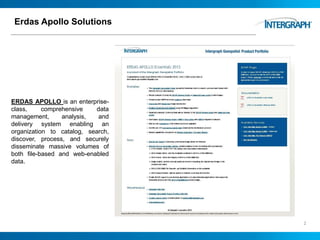
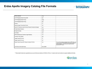
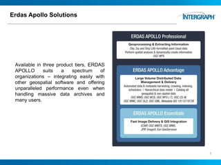
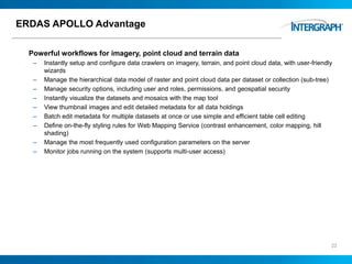
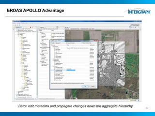
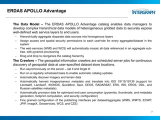
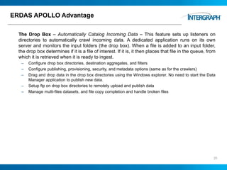
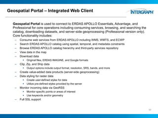
ERDAS APOLLO is an enterprise-class, comprehensive data management, analysis, and delivery system enabling an organization to catalog, search, discover, process, and securely disseminate massive volumes of both file-based and web-enabled data.
In questa presentazione, tutte le novità e una carrellata completa degli strumenti software del Power Portfolio 2016 di Hexagon Geospatial™.
La release 2016 dei software ERDAS IMAGINE, ERDAS APOLLO, Geomedia e di tutti gli altri strumenti software del Power Portfolio di Hexagon Geospatial è stata presentata ufficialmente il 14 giugno 2016, durante l’evento Hexagon Live di Anaheim (California).
Il Portfolio si compone di tre suite: Producer, Provider e Platform, costituite da prodotti software allo stato dell’arte ed utilizzati in tutto il mondo, che combinano le migliori tecnologie attualmente disponibili nel settore del telerilevamento, della fotogrammetria, del GIS ed in generale per la gestione di dati geospaziali.
Guarda il video e scarica il documento in italiano sulle novità della release 2016 su:
http://www.planetek.it/news_eventi/archivio_news/2016/06/presentato_il_nuovo_power_portfolio_2016_di_hexagon_geospatial
ERDAS IMAGINE is a remote sensing image processing software that allows users to import imagery from satellite and aerial platforms and extract useful geospatial information. It has three product tiers - Essentials, Advantage, and Professional - that scale in functionality. The software also includes additional specialized modules like Virtual GIS and Radar Mapping Suite. ERDAS IMAGINE enables tasks like land cover classification, camera placement, integration with Google Earth and Bing Maps, measurement of vertical features, map report generation, and flood modeling.
Irish Earth Observation Symposium 2014: Point Cloud Data Management with ERDA...IMGS
Rapid increase in the volume and number of imagery data sets places significant pressures on data managers – they need to be able to place new data sets in a controlled enterprise data management environment that ensures the maximum number of authorised users are able to find and access the resource.
GWT 2014: Emergency Conference - 02 le soluzioni geospaziali per la gestione ...Planetek Italia Srl
Geospatial World Tour 2014: Emergency Conference.
Napoli, 28 maggio 2014.
Le soluzioni Geospaziali per la gestione delle emergenze.
Simone Colla, Hexagon Geospatial
This document discusses 5-sense computing in robots for remote monitoring applications. It describes how giving robots human-like senses such as sight, hearing, smell, taste and touch would allow them to be used for remote inspection in hazardous environments. Current robotic sensing capabilities are outlined and examples of using multi-sensory robots for remote quality control, tank inspections and underground mine monitoring are provided. The networking requirements for transmitting multi-sensory data from robots in real-time are also summarized.
Pioneered a decade ago for satellite remote sensing, eCognition enables geospatial data such as images, point clouds and Geographic Information System (GIS) vectors to be integrated and analyzed to quantify features or detect changes over time. eCognition 8.8 now extends these capabilities for mobile terrestrial data collection applications.
Creating next-gen VR and MR experiences using Varjo VR-1 and XR-1 - Unite Cop...Unity Technologies
The developers of Varjo VR-1 learned a lot about human eye resolution and the demands it puts on virtual reality (VR) content. In these slides, you'll explore what next-generation VR can mean for your VR experiences. Learn about what matters the most when it comes to visual quality, the possible caveats, and the role performance requirements play in this equation.
Speaker:
Mikko Strandborg - Varjo
Providing New Geographic Solutions to the Company Esri
The document summarizes the IT department's experience with ESRI GIS software over time at Canal de Isabel II, including:
1) Early GIS used custom AutoCAD-based software which was difficult to maintain and had poor performance.
2) ArcGIS Desktop provided more powerful tools but custom development led to high upgrade costs. The version control system was also complex.
3) Initial ArcIMS web mapping had limited functionality and slow performance.
4) Later versions of ArcGIS Server improved web mapping capabilities and speed through cached map services.
5) Mobility projects were disrupted when Microsoft changed the Windows Mobile platform, requiring a shift to other mobile platforms supported by ESRI.
The document provides an overview of the GXL ortho mosaicking system from PCI Geomatics. It discusses the scalable, automated, and accurate architecture of GXL which uses state-of-the-art hardware and algorithms. The document outlines the key components of GXL including processing servers, a controller, client computers, quality control workstations, and a data server. It also describes the advanced processing capabilities of GXL including GPU processing, parallel processing, and distributed processing.
Takes the reader through the various components of windowing systems, and how to develop and benchmark various Graphics applications using OpenGL and other toolsets. Also includes a Cheatsheet that covers various terminologies used in the Graphics world.
Engineering Art at Autodesk University 2013 TheDewberryWay
"Based on the successful construction of a sustainable water reuse (purple pipe) project, this class breaks down the steps for managing large diameter (20 inch +) waterlines on major (5+ miles) projects. We show the basics for modeling existing utilities, managing updates to utility models based on test pit data, and pulling from the AutoCAD® Civil 3D® road design toolset to develop waterline models. As we begin to dive into the pressure pipe tools of Civil 3D 2014, we discuss the transition to those new features. Next, we show you how to market the process of design on infrastructure projects, so as to show the 3D elements of what's still delivered as 2D paper plans. With expansive projects, the use of InfraWorks™ software has provided a great set of tools for quickly compiling data from multiple sources into a single location and present visualizations based on active design files to clients and the community." - AutoDesk 2013 Website (http://goo.gl/tBDDEu)
What's ahead for film and animation with Unity 2020 - Unite Copenhagen 2019Unity Technologies
Unity is enabling film and animation studios to revolutionize their pipelines with features developed specifically to empower storytellers who are creating linear and interactive content. Learn more about features such as Python, Shotgun, the Arbitrary Output Variables (AOV) used in Recorder for export, Alembic, and Universal Scene Description (USD).
Speaker:
Mathieu Muller - Unity
Watch the session on YouTube: https://youtu.be/wrc3R-BoDGs
Developing and optimizing a procedural game: The Elder Scrolls Blades- Unite ...Unity Technologies
The Elder Scrolls Blades strove to produce high-quality visuals on modern mobile devices. This talk will describe the challenges of achieving that level of quality in procedurally generated 3D environments.
Speakers:
Simon-Pierre Thibault - Bethesda Game Studios
Sergei Savchenko - Bethesda Game Studios
Watch the session here: https://youtu.be/KbxiGH6igBk
Optimizing HDRP with NVIDIA Nsight Graphics – Unite Copenhagen 2019Unity Technologies
Unity's High Definition Render Pipeline (HDRP) makes it possible for developers to unleash their application's full potential using a custom renderer. With this great power, comes great responsibility; more than ever you need to ensure that your application maintains optimal performance so your users can have the best experience possible. These slides look at using NVIDIA Nsight Graphics to profile and optimize your application to achieve peak performance. See how GPU Trace can help you visualize performance metrics to fully utilize your GPU; and how the brand new Shader Profile can help you to optimize your new HDRP shaders.
This session also showed how to utilize advanced features like the Acceleration Structure Viewer to debug your real-time ray tracing (DXR) application.
Speaker: Aurelio Reis – NVIDIA
Watch the session on YouTube: https://youtu.be/l_LiE1vAFhM
The document summarizes two CAD software programs: IronCAD and the NISA family of software. For IronCAD, it describes the key benefits as improved design productivity through its drag and drop interface, design flexibility through its dual kernel support and direct face modeling, and ease of use features. It also allows fully associative production drawings. For NISA, it describes the various analysis modules in the family including static/dynamic analysis, rotor dynamics, composites, heat transfer, fatigue, and computational fluid dynamics. NISA includes a graphics pre and post-processor called DISPLAY.
Implementation of a geographic information systems (GIS)-based system to eval...Chad Cooper
The document describes the development of a GIS-based system called VIESORE to evaluate the visual impact of offshore renewable energy installations for the Bureau of Ocean Energy Management. The system allows users to import spatial data, design offshore facility layouts, generate photorealistic 3D visualizations from different viewpoints under varying conditions, and output reports and images. It integrates 3D modeling software with a customized ArcGIS interface for a user-friendly workflow. Development to date includes importing real-world GIS data into the 3D software and creating initial visualization renderings.
FME is typically used to exchange data, but it can also be used as a powerful tool to automate the transformation of spatial data into technical CAD diagrams. In this presentation I will show how I embedded FME into an application process to create on-the-fly AutoCAD diagrams for communication manholes. This involves determining the local spatial reference, calculating the extents required, clipping the data, creating labels for the data, filtering the data to set line colors and styles, and then exporting the file using linked workspaces.
Getting started with Ray Tracing in Unity 2019.3 - Unite Copenhagen 2019Unity Technologies
In these slides, you will learn the basics to help you get started with ray tracing in Unity 2019.3.
Speakers:
Soner Sen - Unity
Kate McFadden - Unity
Dany Ayoub - Unity
The document describes a ground-truthing engine that was developed to help manually correct errors and quality assure documents during the digitization of a large collection of out-of-print books. The ground-truthing engine provides tools for users to easily specify zoning, regions, and layout corrections through a simple graphical user interface. It integrates the same zoning and analysis engines used during automated processing to help streamline the manual quality assurance work. The system was able to reduce errors to less than 3% of documents, requiring around 6 human-weeks of effort to fully proofread the collection of over 1.2 million pages.
Mapping For Sharepoint T11 Peter SmithSpatialSmith
This document summarizes a presentation about mapping solutions that can be integrated into Sharepoint. It provides an overview of spatial data and mapping, demonstrates how to add maps to Sharepoint using solutions like SQL Server 2008, OpenLayers and ComponentOne Maps for Sharepoint. It also previews upcoming features in SQL Server 2008 R2 and takes questions at the end.
NX 7.5 provides major updates across multiple areas of the flagship Siemens PLM software including modeling, simulation, and data management. Key enhancements include lightweight JT data viewing for larger datasets, improved sketching and synchronous modeling capabilities extended to freeform geometry, and deeper integration of simulation and physical test results. The high definition 3D tools now directly integrate with the Teamcenter data management system to provide richer graphical reports and flexibility within NX. Overall, the release further matures the product to support a wide range of industries and complex design workflows.
This document provides an introduction and overview of optical CAD tools. It discusses what CAD is, the benefits of using CAD tools, and different propagation models in optical CAD. It then classifies and describes several popular CAD tools for lens design, laser and integrated optics design, thin film design, illumination and straylight design, testing software, and optical signal simulation. Key tools discussed include ZEMAX, CODE V, LightTools, TF Companion, TracePro, OptiSystem, and OptSim. The document serves to introduce the reader to the field of optical CAD tools and provides examples of software used for different optical design applications.
How the Universal Render Pipeline unlocks games for you - Unite Copenhagen 2019Unity Technologies
Learn how the Boat Attack demo was created using the Universal Render Pipeline. These slides offer an in-depth look at the features used in the demo, including Shader Graph, Custom Render Passes, Camera Callback, and more.
Speaker:
Andre McGrail - Unity Technologies
Watch the session on YouTube: https://youtu.be/ZPQdm1T7aRs
UAV imagery processed through SfM software yields ortho mosaics that can be then analyzed further. Automated image alignment makes time series analysis possible. Find out how Geomatica can be used to help you get more from imagery. From LAS point cloud interpolation, image to image alignment, vegetation assessment, stockpile measurement, and more. Geomatica also includes a python powered development platform making it the best option to extend processing capability to develop operational applications.
Towards Rapid Implementation of Adaptive Robotic SystemsMeshDynamics
Current automation design practice produces expensive one-of-a-kind installations where the system cannot be easily modified to
meet changing demands or advancements in technology. It is imperative that we design robot systems to be modular, portable and
easily re-configurable in order to reduce the design lead times and life cycle costs of providing automation alternatives.
The Unified Tele-robotics Architecture Program (UTAP) was developed under the sponsorship of the US Air Force Robotics and
Automation Center of Excellence. A goal of the program was to define and develop prototypes of commonly used software building
blocks for sensor guided real time embedded control of telerobotic devices. Standard building blocks and a non-proprietary
communication protocols would provide the Air Force and specifically the Logistic Centers with a support infrastructure designed to
rapidly and efficiently build and maintain mission critical automation systems.
This document discusses graphics software and its functions. There are two types of graphics software: general programming packages that provide graphics functions for use in languages like C/FORTRAN, and special-purpose applications for non-programmers. General packages use Cartesian coordinates and provide functions for primitives, attributes, transformations, and input handling. Standards like GKS and PHIGS implement official specifications to promote portability.
With the advent of higher powered 3D scanners comes the challenge of dealing with the dense point cloud data sets. Direct Dimensions uses a wide variety of 3D scanning equipment to capture the as-built shape of existing objects. The common problem with all of these projects is the need to proces the point cloud data.
While applications fall generally into either reverse engineering and inspection, both directions present challenges for processing the large data sets efficiently, quickly, and properly. This presentation will focus on an overview of the software tools available commercially that address these problems with a comparison of the various workflows, strategies, and results that one can expect from the various solutions.
Centre for Natural Disaster Science (CNDS) – a strategic Swedish initiative f...Global Risk Forum GRFDavos
Sven HALLDIN1,2, Fredrik BYNANDER1,3
1Centre for Natural Disaster Science, Sweden, Kingdom of; 2Department of Earth Sciences, Uppsala University, Sweden; 3Swedish National Defence College
Apollo Tyres focuses on customer safety through their YOU-FIRST technology, ensuring tires are rigorously tested before use and manufactured in state-of-the-art facilities. Their tires travel through a long development process involving global research and testing to complement modern vehicles before being made available to customers, who are the start and end point of Apollo's efforts.
The document provides an overview of SWOT analysis, a planning tool used to identify an organization's strengths, weaknesses, opportunities, and threats. It defines each component of a SWOT analysis: strengths and weaknesses are internal factors within an organization's control, while opportunities and threats are external factors. Examples are given for each category. The document also discusses how to conduct a SWOT analysis and its potential uses, such as setting objectives, environmental scanning, analyzing strategies, and establishing critical success factors.
Apollo Tyres case study analysis - HR perspectiveShubham Singhal
This case study summarizes the transformation of Apollo Tyres under Onkar Kanwar's leadership. Key changes included establishing a formal HR department to improve recruitment, performance management, and employee development. A new online performance management system called PACE was implemented, along with recognition programs to reward top performers. The Apollo Laureate Academy was also launched to provide leadership training programs to help develop managers for future roles. These HR initiatives helped professionalize Apollo's practices and build an engaged, high-performing workforce.
- Apollo Tyres Ltd is the world's 17th biggest tire manufacturing company with annual revenue of Rs. 125.7 billion.
- Founded in 1976 in Kerala, India, it now has 4 manufacturing plants in India, South Africa, and Zimbabwe and plans to expand to 10 plants worldwide.
- It sells over 30,000 tires per month in Europe and plans to open a new factory in Hungary in 2017.
This document summarizes an environmental scan conducted by the Boston Consulting Group for Apollo Tyres to identify opportunities and threats in India. The scan analyzed how factors like agriculture, industrial performance, transportation and vehicle production impact the tyre industry. It found the industry is primarily demand-driven and dependent on original equipment and replacement segments. The main macro factors selected for analysis were GDP, industrial production, road length and inflation. The scan concluded increasing income, consumption and vehicle production present opportunities for Apollo Tyres to partner with automakers and target youth. Tying rural sales to tractors and motorcycles was also recommended.
Apollo Tyres Ltd generates 59% of its revenue from India, 28% from Europe, and 13% from Africa. It has operations in India, the Netherlands, South Africa, and Zimbabwe. The company's vision is to become a significant global tyre player and a preferred brand that enhances stakeholder value. The Indian tyre industry is worth approximately Rs. 225 billion with the top players being Apollo Tyres, MRF, JK Tyres, and Ceat, which combined account for 75% of industry turnover. Apollo Tyres has grown its net worth, net current assets, net block, and total debt between 2007-2011. It has also increased total operating income, profits, earnings per share, and
This document describes a business storage solution called ROBUSTnodeTM that provides scalable and reliable storage for businesses. It has innovative features like expanding storage capacity, supporting large petabyte storage needs, seamless auto-backup, and drive redundancy. The solution is affordable and supports major operating systems. It also provides monitoring, management and multiple functions in one device. The company offers additional services like storage design, implementation, and managed services.
Introduction to Software Defined Visualization (SDVis)Intel® Software
This document provides an overview of Intel's Software Defined Visualization (SDVis) initiative and updates on its current status. SDVis aims to enable scalable, flexible visualization that can run on a variety of systems from laptops to large clusters. It utilizes several open source libraries developed by Intel including Embree for ray tracing, OSPRay as a rendering engine, and OpenSWR for rasterization. The document discusses how SDVis addresses challenges of large-scale, high performance visualization. It provides examples of scientific visualization projects using SDVis and performance comparisons of Embree and OSPRay to GPU-based solutions. In addition, the document outlines several active integrations of SDVis technologies in visualization software including ParaView and
Mihai Nuta has over 14 years of experience developing computer systems and applications. He has extensive experience with technologies like Visual Basic, SQL, Oracle, and .NET. Currently he works as a senior programmer analyst at Xerox Corporation developing applications for General Motors, including a legal document application and tools for processing images and documents. He has strong skills in databases, web and client/server development, and software like Microsoft Office, SQL Server, and Visual Studio.
We will summarize current status of HDF-EOS and associated tools. Update on HDF-EOS, HDFView plug-in and The HDF-EOS to GeoTIFF (HEG) conversion tool, including recent changes to the software, ongoing maintenance, upcoming releases, future plans, and issues will be discussed.
We will also summarize the status of HDF-EOS RFC. The HDF-EOS plug-in for the THG-developed tool, HDFView, has been enhanced. The plug-in offers browse capability for both HDF4 and HDF5 - based HDF-EOS files. HDFView can also process vanilla HDF4 and HDF5 files. New features including support for Point and Zonal Average objects have been added. A port to Mac OS X version will be available in next release.
The HDF-EOS to GeoTIFF (HEG) conversion tool has been augmented to include new projections, and support for additional AMSR-E and AIRS products. Subsetting features have also been augmented. The tool is available in both stand-alone and EOS DAAC online versions.
For the full video of this presentation, please visit:
http://www.embedded-vision.com/platinum-members/embedded-vision-alliance/embedded-vision-training/videos/pages/may-2014-embedded-vision-summit-khronos
For more information about embedded vision, please visit:
http://www.embedded-vision.com
Neil Trevett, President of Khronos and Vice President at NVIDIA, presents the "OpenVX Hardware Acceleration API for Embedded Vision Applications and Libraries" tutorial at the May 2014 Embedded Vision Summit.
This presentation introduces OpenVX, a new application programming interface (API) from the Khronos Group. OpenVX enables performance and power optimized vision algorithms for use cases such as face, body and gesture tracking, smart video surveillance, automatic driver assistance systems, object and scene reconstruction, augmented reality, visual inspection, robotics and more.
OpenVX enables significant implementation innovation while maintaining a consistent API for developers. OpenVX can be used directly by applications or to accelerate higher-level middleware with platform portability. OpenVX complements the popular OpenCV open source vision library that is often used for application prototyping.
Виктор Ерухимов Open VX mixar moscow sept'15 mixARConference
This document discusses computer vision acceleration using the OpenVX API. It provides an overview of OpenVX, including its graph-based programming model and functions for image processing, feature extraction and tracking. OpenVX aims to provide portable, low-power vision acceleration across different hardware platforms. An example demonstrates using OpenVX nodes to implement feature tracking via optical flow in a graph containing color conversion, pyramid generation and Lucas-Kanade optical flow estimation nodes.
For the full video of this presentation, please visit:
http://www.embedded-vision.com/platinum-members/embedded-vision-alliance/embedded-vision-training/videos/pages/mar-2014-member-meeting-khronos
For more information about embedded vision, please visit:
http://www.embedded-vision.com
Neil Trevett, President of Khronos and Vice President at NVIDIA, delivers the standards presentation, "Recent Developments in Khronos Standards for Embedded Vision," at the March 2014 Embedded Vision Alliance Member Meeting.
Anton Vysotskiy is seeking a position as a software architect or senior software developer/team lead. He has over 15 years of experience developing software using a variety of languages including Java, Groovy, Scala, JavaScript, and C#/.NET. He has extensive experience developing web applications using frameworks like Spring, Hibernate, and AngularJS.
Customizable Embedded 3D Surround View Turn-Key Solution on Apalis iMX6 SoMToradex
Toradex's partner TES Electronic Solutions GmbH presents a customizable 3D Surround View Turn-Key solution based on the Toradex Apalis iMX6 SoM that can be quickly adapted concerning the specific requirements of the targeted vehicle. Read more in their guest blog post here: https://www.toradex.com/blog/customizable-embedded-3d-surround-view-turn-key-solution-apalis-imx6-som
This document introduces Geo Nuris, an enterprise GIS software developed by CCI Co., Ltd. It consists of Geo Nuris products like the web server, spatial server, and desktop pro. The benefits highlighted are that it is OGC certified, supports multiple GIS databases and formats, and has high performance. Examples shown include searching poles in the electric package, underground switch editing with map mashups, substation selection and feeder tracing with thematic maps, and automatic schematics diagram generation. Case studies demonstrated include KEPCO smart grid applications and a BI web dashboard.
The document discusses the Enlightenment Foundation Libraries (EFL), an open source UI toolkit designed for embedded systems. EFL was created for Enlightenment 17 and focuses on optimization for devices with limited resources. It includes components like Evas for rendering, Edje for themes/layout, and Elementary for widgets. EFL is used in Samsung products like smartwatches, cameras, phones and TVs. The presentation covers EFL architecture, optimizations, current developments improving performance and functionality, and its future direction.
The PACS Nano is a path breaking design which exploits cloud computing and the availability off-the-shelf computer hardware to build an affordable, easy-to-use PACS that delivers robust performance with comprehensive functionality.
A solutions specifically designed for smaller hospitals and diagnostic centres targeting up to 10,000 patient exams per year is adequate for most radiology departments.
The simplicity of design also minimizes the cost and efforts for IT Administration, training and support, as even complex workflows involving multiple sites and teleradiology can be easily managed using Freedom Cloud sync.
The software allows users to access both images & reports from any computer in the facility.
The Innowave Freedom Nano supports audit trails image tracking for easy system management and ability to monitor and control the movement of patient studies
All usage statistics and key dashboards are available to display key operation deliverable like turnaround time etc.
The DICOM Image Viewer support basic DICOM print and archiving in CD, DVD media.
Innowave Healthcare has created enhanced reporting workflow solution provided for the Radiologist and Typist by seamlessly integrating “Microsoft word” with Freedom PACS.
The document provides contact information for Exor International subsidiaries around the world, including in Italy, Germany, India, Switzerland, and the USA. It then lists Exor HMI product lines such as the eTOP and eBIS series and accessories like handheld units. The remainder of the document describes features of the JMobile programming software and Exor HMI hardware solutions.
The document discusses the current status and future plans for HDF-EOS, a software toolkit for working with Earth science data files. It notes that maintenance support is funded through May 2009, with one full-time and one half-time developer. Major software components like the SDP Toolkit, HDF-EOS2, HDF-EOS5, and the HDF-EOS to GeoTIFF Converter are maintained and new releases planned. Future development focuses on auto-configuration, 64-bit support, and improved tools for viewing and converting HDF-EOS files.
Graphic standards and exchange formatskishor kumar
The document discusses graphics standards and the need for data exchange standards when transferring CAD files between different software and hardware platforms. It covers early issues with hardware dependence and the development of device-independent standards like GKS. It also summarizes several important neutral CAD data exchange standards, including DXF, IGES, STEP, and discusses some of their limitations in fully transferring design intent and parametric models. It proposes a macro-parametric approach using standardized modeling commands to improve the exchange of CAD files while maintaining parametric design histories.
Aerospike Today and Tomorrow Product Roadmap 2023_Lenley Hensarling.pdfAerospike, Inc.
The Aerospike data platform pushes the boundaries of what a real-time data system can do stemming from our core design center principles. Hear from the Aerospike Chief Product Officer, Lenley Hensarling, about the advances being made now and in the near future surrounding multi-model capabilities like support for property graphs, multi-record transactions, observability and management, in-memory advances, Kubernetes operator, and more.
The Scality RING is a software-defined storage platform that runs on standard x86 servers and is designed to scale linearly across multiple sites and thousands of servers to store petabytes of data. It provides a single, distributed storage system with unlimited storage capacity and high durability through data replication and erasure coding. The hardware-agnostic RING architecture ensures continuous availability during hardware upgrades and failures.
How information systems are built or acquired puts information, which is what they should be about, in a secondary place. Our language adapted accordingly, and we no longer talk about information systems but applications. Applications evolved in a way to break data into diverse fragments, tightly coupled with applications and expensive to integrate. The result is technical debt, which is re-paid by taking even bigger "loans", resulting in an ever-increasing technical debt. Software engineering and procurement practices work in sync with market forces to maintain this trend. This talk demonstrates how natural this situation is. The question is: can something be done to reverse the trend?
"Scaling RAG Applications to serve millions of users", Kevin GoedeckeFwdays
How we managed to grow and scale a RAG application from zero to thousands of users in 7 months. Lessons from technical challenges around managing high load for LLMs, RAGs and Vector databases.
AppSec PNW: Android and iOS Application Security with MobSFAjin Abraham
Mobile Security Framework - MobSF is a free and open source automated mobile application security testing environment designed to help security engineers, researchers, developers, and penetration testers to identify security vulnerabilities, malicious behaviours and privacy concerns in mobile applications using static and dynamic analysis. It supports all the popular mobile application binaries and source code formats built for Android and iOS devices. In addition to automated security assessment, it also offers an interactive testing environment to build and execute scenario based test/fuzz cases against the application.
This talk covers:
Using MobSF for static analysis of mobile applications.
Interactive dynamic security assessment of Android and iOS applications.
Solving Mobile app CTF challenges.
Reverse engineering and runtime analysis of Mobile malware.
How to shift left and integrate MobSF/mobsfscan SAST and DAST in your build pipeline.
LF Energy Webinar: Carbon Data Specifications: Mechanisms to Improve Data Acc...DanBrown980551
This LF Energy webinar took place June 20, 2024. It featured:
-Alex Thornton, LF Energy
-Hallie Cramer, Google
-Daniel Roesler, UtilityAPI
-Henry Richardson, WattTime
In response to the urgency and scale required to effectively address climate change, open source solutions offer significant potential for driving innovation and progress. Currently, there is a growing demand for standardization and interoperability in energy data and modeling. Open source standards and specifications within the energy sector can also alleviate challenges associated with data fragmentation, transparency, and accessibility. At the same time, it is crucial to consider privacy and security concerns throughout the development of open source platforms.
This webinar will delve into the motivations behind establishing LF Energy’s Carbon Data Specification Consortium. It will provide an overview of the draft specifications and the ongoing progress made by the respective working groups.
Three primary specifications will be discussed:
-Discovery and client registration, emphasizing transparent processes and secure and private access
-Customer data, centering around customer tariffs, bills, energy usage, and full consumption disclosure
-Power systems data, focusing on grid data, inclusive of transmission and distribution networks, generation, intergrid power flows, and market settlement data
inQuba Webinar Mastering Customer Journey Management with Dr Graham HillLizaNolte
HERE IS YOUR WEBINAR CONTENT! 'Mastering Customer Journey Management with Dr. Graham Hill'. We hope you find the webinar recording both insightful and enjoyable.
In this webinar, we explored essential aspects of Customer Journey Management and personalization. Here’s a summary of the key insights and topics discussed:
Key Takeaways:
Understanding the Customer Journey: Dr. Hill emphasized the importance of mapping and understanding the complete customer journey to identify touchpoints and opportunities for improvement.
Personalization Strategies: We discussed how to leverage data and insights to create personalized experiences that resonate with customers.
Technology Integration: Insights were shared on how inQuba’s advanced technology can streamline customer interactions and drive operational efficiency.
Dandelion Hashtable: beyond billion requests per second on a commodity serverAntonios Katsarakis
This slide deck presents DLHT, a concurrent in-memory hashtable. Despite efforts to optimize hashtables, that go as far as sacrificing core functionality, state-of-the-art designs still incur multiple memory accesses per request and block request processing in three cases. First, most hashtables block while waiting for data to be retrieved from memory. Second, open-addressing designs, which represent the current state-of-the-art, either cannot free index slots on deletes or must block all requests to do so. Third, index resizes block every request until all objects are copied to the new index. Defying folklore wisdom, DLHT forgoes open-addressing and adopts a fully-featured and memory-aware closed-addressing design based on bounded cache-line-chaining. This design offers lock-free index operations and deletes that free slots instantly, (2) completes most requests with a single memory access, (3) utilizes software prefetching to hide memory latencies, and (4) employs a novel non-blocking and parallel resizing. In a commodity server and a memory-resident workload, DLHT surpasses 1.6B requests per second and provides 3.5x (12x) the throughput of the state-of-the-art closed-addressing (open-addressing) resizable hashtable on Gets (Deletes).
Session 1 - Intro to Robotic Process Automation.pdfUiPathCommunity
👉 Check out our full 'Africa Series - Automation Student Developers (EN)' page to register for the full program:
https://bit.ly/Automation_Student_Kickstart
In this session, we shall introduce you to the world of automation, the UiPath Platform, and guide you on how to install and setup UiPath Studio on your Windows PC.
📕 Detailed agenda:
What is RPA? Benefits of RPA?
RPA Applications
The UiPath End-to-End Automation Platform
UiPath Studio CE Installation and Setup
💻 Extra training through UiPath Academy:
Introduction to Automation
UiPath Business Automation Platform
Explore automation development with UiPath Studio
👉 Register here for our upcoming Session 2 on June 20: Introduction to UiPath Studio Fundamentals: https://community.uipath.com/events/details/uipath-lagos-presents-session-2-introduction-to-uipath-studio-fundamentals/
Connector Corner: Seamlessly power UiPath Apps, GenAI with prebuilt connectorsDianaGray10
Join us to learn how UiPath Apps can directly and easily interact with prebuilt connectors via Integration Service--including Salesforce, ServiceNow, Open GenAI, and more.
The best part is you can achieve this without building a custom workflow! Say goodbye to the hassle of using separate automations to call APIs. By seamlessly integrating within App Studio, you can now easily streamline your workflow, while gaining direct access to our Connector Catalog of popular applications.
We’ll discuss and demo the benefits of UiPath Apps and connectors including:
Creating a compelling user experience for any software, without the limitations of APIs.
Accelerating the app creation process, saving time and effort
Enjoying high-performance CRUD (create, read, update, delete) operations, for
seamless data management.
Speakers:
Russell Alfeche, Technology Leader, RPA at qBotic and UiPath MVP
Charlie Greenberg, host
Freshworks Rethinks NoSQL for Rapid Scaling & Cost-EfficiencyScyllaDB
Freshworks creates AI-boosted business software that helps employees work more efficiently and effectively. Managing data across multiple RDBMS and NoSQL databases was already a challenge at their current scale. To prepare for 10X growth, they knew it was time to rethink their database strategy. Learn how they architected a solution that would simplify scaling while keeping costs under control.
[OReilly Superstream] Occupy the Space: A grassroots guide to engineering (an...Jason Yip
The typical problem in product engineering is not bad strategy, so much as “no strategy”. This leads to confusion, lack of motivation, and incoherent action. The next time you look for a strategy and find an empty space, instead of waiting for it to be filled, I will show you how to fill it in yourself. If you’re wrong, it forces a correction. If you’re right, it helps create focus. I’ll share how I’ve approached this in the past, both what works and lessons for what didn’t work so well.
"Frontline Battles with DDoS: Best practices and Lessons Learned", Igor IvaniukFwdays
At this talk we will discuss DDoS protection tools and best practices, discuss network architectures and what AWS has to offer. Also, we will look into one of the largest DDoS attacks on Ukrainian infrastructure that happened in February 2022. We'll see, what techniques helped to keep the web resources available for Ukrainians and how AWS improved DDoS protection for all customers based on Ukraine experience
Conversational agents, or chatbots, are increasingly used to access all sorts of services using natural language. While open-domain chatbots - like ChatGPT - can converse on any topic, task-oriented chatbots - the focus of this paper - are designed for specific tasks, like booking a flight, obtaining customer support, or setting an appointment. Like any other software, task-oriented chatbots need to be properly tested, usually by defining and executing test scenarios (i.e., sequences of user-chatbot interactions). However, there is currently a lack of methods to quantify the completeness and strength of such test scenarios, which can lead to low-quality tests, and hence to buggy chatbots.
To fill this gap, we propose adapting mutation testing (MuT) for task-oriented chatbots. To this end, we introduce a set of mutation operators that emulate faults in chatbot designs, an architecture that enables MuT on chatbots built using heterogeneous technologies, and a practical realisation as an Eclipse plugin. Moreover, we evaluate the applicability, effectiveness and efficiency of our approach on open-source chatbots, with promising results.
"What does it really mean for your system to be available, or how to define w...Fwdays
We will talk about system monitoring from a few different angles. We will start by covering the basics, then discuss SLOs, how to define them, and why understanding the business well is crucial for success in this exercise.
The Microsoft 365 Migration Tutorial For Beginner.pptxoperationspcvita
This presentation will help you understand the power of Microsoft 365. However, we have mentioned every productivity app included in Office 365. Additionally, we have suggested the migration situation related to Office 365 and how we can help you.
You can also read: https://www.systoolsgroup.com/updates/office-365-tenant-to-tenant-migration-step-by-step-complete-guide/
Northern Engraving | Modern Metal Trim, Nameplates and Appliance PanelsNorthern Engraving
What began over 115 years ago as a supplier of precision gauges to the automotive industry has evolved into being an industry leader in the manufacture of product branding, automotive cockpit trim and decorative appliance trim. Value-added services include in-house Design, Engineering, Program Management, Test Lab and Tool Shops.
ScyllaDB is making a major architecture shift. We’re moving from vNode replication to tablets – fragments of tables that are distributed independently, enabling dynamic data distribution and extreme elasticity. In this keynote, ScyllaDB co-founder and CTO Avi Kivity explains the reason for this shift, provides a look at the implementation and roadmap, and shares how this shift benefits ScyllaDB users.
2. Erdas Apollo Solutions
2
ERDAS APOLLO is an enterprise-
class, comprehensive data
management, analysis, and
delivery system enabling an
organization to catalog, search,
discover, process, and securely
disseminate massive volumes of
both file-based and web-enabled
data.
5. Erdas Apollo Solutions
5
Available in three product tiers, ERDAS
APOLLO suits a spectrum of
organizations – integrating easily with
other geospatial software and offering
unparalleled performance even when
handling massive data archives and
many users.
6. ERDAS APOLLO Essentials
ERDAS APOLLO Essentials is the fastest geospatial image server in the world. A
single server with standard hardware can serve terabytes of data to thousands of
concurrent users. ERDAS APOLLO Essentials works with your GIS to provide
geospatial data as quickly as possible.
6
Key Features
- Performance
- Multiple Image Serving Protocols
- Enhanced Compression Wavelet Protocol (ECWP) Image Streaming Protocol
- OGC® WMS 1.1.1 & 1.3.0 / WMS-C
- OGC WMTS v1.0.0
- Security
- GIS Integration
- Image Viewing
- Administration
- Online Image Processing Support
7. ERDAS APOLLO Essentials
Performance
The fastest image server in the world. Demo ERDAS
Supports massive imagery – Deliver terabytes of image data with a single server
Native 64-bit architecture – True 64-bit support enables large memory caches and faster
overall performance due to 64-bit registers
Cache – ECWP controls cache data reducing bandwidth requirements and continually. Web
browser plug-in permits cache persistence over multiple browser visits.
Hardware-accelerated
ECWP streaming protocol
– ERDAS APOLLO Essentials scales efficiently to support thousands of concurrent users by
implementing the Intergraph-patented delivery protocol to stream compressed data to clients to create
a distributed decompression environment.
OGC-compliant Web Map Service (WMS) and Web Map Tiling Service (WMTS) protocols
– High-performance, standards-compliant interfaces
– Allow OGC-compliant third-party applications to consume many image formats
Narrow to broadband scalability
– Capable of serving images faster regardless of the bandwidth or network latency to users. ERDAS
APOLLO Essentials will serve image data faster than any other solution.
7
9. ERDAS APOLLO Essentials
Multiple Image Serving Protocols
– Multi-protocol support
– Expose images with different protocols
Enhanced Compression Wavelet Protocol (ECWP) Image Streaming Protocol
– Client-side decompression of image data, providing:
– Asynchronous panning and zooming of imagery
– Intelligent client-side caching and image decompression
– Reduced bandwidth requirements
– Optimum user experience
– Serve ECW and JPEG 2000 files via this protocol
Optimized Tile Delivery
– Fast delivery of pre-cached image tiles to browser-based applications
– Servers can be configured to deliver 4,000+ image tiles per second
– Deliver rasterized vector/feature data together in a single OTDF file
– Serve your feature data with ERDAS APOLLO Essentials
9
10. ERDAS APOLLO Essentials
OGC® WMS 1.1.1 & 1.3.0 / WMS-C
– XML-based requests
– On-the-fly image reprojection
– Configure multiple WMS services on the same ERDAS APOLLO Essentials server
– Fully compliant with OGC WMS v1.1.1 and v1.3.0
– Scale dependent images from WMS services
– Fastest and most efficient OGC WMS for imagery data in terms of data storage requirements,
hardware requirements, and delivery speed
OGC WMTS v1.0.0
– High-performance tile delivery through the OGC-compliant Web Map Tiling Service interface
– Allow third-party applications to consume OTDF, ECW, and many other formats through WMTS
– Enable only selected images through the WMTS service interface
– Select from default OGC Well Known Tiles Matrix Sets per layer or configure custom ones
– Fully compliant with the OGC WMTS v1.0 TEAM Engine
– No client-side plug-in is required
– Easily create mashups with OpenLayers and Google Maps™
10
11. ERDAS APOLLO Essentials
Other Protocols
– JPEG 2000 Interactive Protocol (JPIP)
File Format Support
– Premium file formats: Read and serve ECW and JPEG 2000 wavelet-based compressed data
formats.
These highly efficient file formats are read from disc – no database is involved. This provides a massive
performance boost.
Write JPEG/PNG (8-bit and 24bit)/JPEG 2000 (use the ERDAS APOLLO Essentials Image Utility for a
greater range of output options).
Create small subsets of image mosaics.
OTDF (Optimized Tile Delivery Format): File format for delivering “tiled” views of image data to a web
browser.
– Standard file formats: GeoTiff, IMG, and MrSID
Additional image formats to enable easy setup of ERDAS APOLLO Essentials image serving solution. For
optimal performance, conversion to ECW of JPEG 2000 is recommended.
11
12. ERDAS APOLLO Essentials
Security
– SSL communication
Image data is encrypted for protocols (ECWPS/HTTPS). Encryption strength based on browser
capabilities.
– Basic file system security
Images are secured on the server and user/group access is controlled by username/password (built on
operating system security)
– Advanced security
Users and their permissions can be stored in a third-party credential management system that the server
can access and use for authentication
– Security based on IP address. Filter user permissions based on originating IP address
– Image resolution/region security. Limit the resolution an image can be viewed at (ground scale). Deny
access to particular regions of an image (e.g. security zone).
12
13. ERDAS APOLLO Essentials
GIS Integration
Desktop applications
– High degree of compatibility with geospatial workstations such as ArcGIS®, ArcView®, MapInfo®,
AutoCAD®, PCI, ER Mapper, Microsoft® Office, Smallworld™, Bentley® MicroStation, etc.
– High-performance image streaming for major GIS workstations
– Plug-ins are available for the following industry workstations to enable efficient streaming image
access with client-side caching:
ESRI – ArcGIS 8x and 9x
ESRI – ArcView
MapInfo Professional ®
AutoCAD
Bentley Microstation
Image Viewing
– Dynamic roam and zoom. Fast and interactive experience for the user.
– Native streaming support in many applications. Many GIS/CAD applications offer native ECWP
readability.
– Free web browser plug-ins. ActiveX or Java plug-in for ECWP protocol.
– Free application plug-ins. Plug-ins for common applications so that users can take advantage of
ECWP streaming.
– Multi-layer image/GIS viewing
13
14. ERDAS APOLLO Essentials
The client component (ActiveX/Java) supports a layered view display with an asynchronous
independent update of each image layer. The viewing control is fully scriptable from
JavaScript providing functions to:
– Set transparency on any image layer using a transparency slider
– Set visibility on any layer
– Set clipping on image layers to restrict an image view to a defined area
– Promote/demote the image order in the viewing “stack”
– Select bands from multi-band imagery
– Provide a means of measuring progressive image loading progress
– Display imagery from industry-standard projections with ability to derive geodetic coordinates from a
point
– Overlay the raster images with maps from GIS servers in a separate image plane
– Set transparency on any color in an image plane
– Support standard image pan, zoom, and zoombox tools
– Support basic red-lining capabilities for circle, rectangle, and irregular polygons
– Support printing of a blended view from the viewing component
– Support viewing of images side by side (i.e. geolinked) with automatic extents tracking between each
view. Web 2.0 control requires the use of server-side component to make GIS requests/knock-out
colors on returned image for transparency.
– NULL cell handling for JPEG 2000 images in all protocols
– NULL cell handling for ECW for WMS, ImageX, and ArcXML. Exact delineation between null areas and
images (no artifacts on the edges).
14
15. ERDAS APOLLO Essentials
Administration
– Powerful, flexible, and straightforward administration console
– Add imagery datasets, define protocols/access levels, etc.
– Remote administration
– Administer the server from anywhere in the world
– View images within administration console
Online Image Processing Support
– Web-based client-side and server-side dynamic image processing
– Contrast and brightness control. It has the capability to generate histograms of the image and modify
the image based on Look Up Tables (LUT).
– Desktop clients image processing
– ERDAS ER Mapper and other applications can be used to access “online images”
– On-the-fly server-side reprojection
15
17. ERDAS APOLLO Advantage
ERDAS APOLLO Advantage s a comprehensive data management and delivery solution
providing remarkable business value. This OGC/ISO standards-based solution can organize
and securely manage and disseminate massive volumes of dynamic and static images, point
cloud data, terrain, vector data, 3rd party web services, and any digital object in the
enterprise. ERDAS APOLLO Advantage is scalable through clustering to meet an
organization’s specific needs, ensuring unprecedented performance even when handling the
largest data archives.
17
ERDAS APOLLO Advantage
integrates the feature set of
ERDAS APOLLO Essentials
18. ERDAS APOLLO Advantage
Enterprise Application Integration – ERDAS APOLLO Advantage is designed to fulfill the
requirements of the most demanding enterprises. Fully scalable through clustering, ERDAS
APOLLO smoothly supports the extension of your geospatial business system with improved
performance. Proven technological standards such as Java EE also ease the integration of
ERDAS APOLLO into secure IT environments.
Key Features
- Typical Workflow
- Advanced Data Management
- Advanced Security
- Data and Metadata Delivery
- Web Client Interface for End Users – Geospatial Portal
18
19. ERDAS APOLLO Advantage
Typical Workflow
Publish, catalog, describe, secure, style, and deliver spatial and non-spatial data in the enterprise.
1. Catalog and publish vector, imagery, and terrain data using OGC-compliant and other
proprietary web services
2. Define scale-dependent styling, allowing multiple user-defined maps to be generated from a
single source
3. Build and configure Web Map Context (WMC) files allowing instant work environment setup
4. Apply role-based, fine-grained, and geospatial security
5. Catalog ERDAS APOLLO services and any OGC-compliant services for easy data discovery
6. Catalog and publish business data (documents, movies, pictures, any electronic content)
7. Discover, visualize, navigate, and download the data using Geospatial Portal
8. Find, filter, and edit vector data using Geospatial Portal
19
20. ERDAS APOLLO Advantage
Advanced Data Management
The ERDAS APOLLO Data Manager – ERDAS APOLLO Advantage provides a desktop
application to remotely and securely crawl, manage, and deliver geospatial imagery, terrain,
vector, point cloud, and any digital data across the enterprise. OpenStreetMap is provided for
global base map context. The ERDAS APOLLO Data Manager can be fully internationalized.
Catalog and deliver spatial and non-spatial data using intuitive wizards
– Instantly set up OGC web services on vector, imagery, and terrain data, using intuitive wizards
– Catalog business data (documents, pictures, movies, URLs, any electronic content)
– Fully configure the services metadata, behavior, and properties using service editors
– Automatically register and update services in the catalog
– Multiple intuitive tools are included to automatically:
Index data
Compute mosaic pyramids
Generate vector data schema and mapping
Style imagery data (band selection, contrast enhancement, hill-shading, and color mapping)
Upload data on the server or remotely browse the server data folders
Instantly visualize your services with the map tool
Edit the ISO metadata (ISO 19115/19139 1.0 and ANZLIC-compliant) served through the OGC interfaces
20
21. ERDAS APOLLO Advantage
21
The ERDAS APOLLO Data Manager allows users to remotely setup and manage
geospatial data and services.
22. ERDAS APOLLO Advantage
Powerful workflows for imagery, point cloud and terrain data
– Instantly setup and configure data crawlers on imagery, terrain, and point cloud data, with user-friendly
wizards
– Manage the hierarchical data model of raster and point cloud data per dataset or collection (sub-tree)
– Manage security options, including user and roles, permissions, and geospatial security
– Instantly visualize the datasets and mosaics with the map tool
– View thumbnail images and edit detailed metadata for all data holdings
– Batch edit metadata for multiple datasets at once or use simple and efficient table cell editing
– Define on-the-fly styling rules for Web Mapping Service (contrast enhancement, color mapping, hill
shading)
– Manage the most frequently used configuration parameters on the server
– Monitor jobs running on the system (supports multi-user access)
22
24. ERDAS APOLLO Advantage
The Data Model – The ERDAS APOLLO Advantage catalog enables data managers to
develop complex hierarchical data models of heterogeneous gridded data to securely expose
well-defined web service layers to end users.
– Hierarchically aggregate disparate data sources into homogenous layers
– Assign access and spatial security permissions to each user/role for every aggregate/dataset in the
system
– The web services (WMS and WCS) will automatically mosaic all data referenced in an aggregate sub-
tree, with pyramid provisioning
– Drag and drop to reorganize the catalog hierarchy
The Crawlers – The geospatial information crawlers are scheduled server jobs for continuous
discovery of geospatial data at user-specified dataset store locations.
– Run asynchronously on the server – set it and forget it!
– Run on a regularly scheduled basis to enable automatic catalog updates
– Automatically discover imagery and terrain data
– Automatically harvest imagery/sensor metadata and translate into ISO 19115/19139 (support for
Landsat5, Landsat7, IKONOS, QuickBird, Spot, CEOS, RADARSAT, ERS, IRS, EROS, ODL, and
Russian satellites metadata).
– Automatically provision data for optimized end-user consumption (pyramids, thumbnails, and metadata
generation, footprint computation, and security configuration)
– Fine grained configuration of the publishing interfaces per dataset/aggregate (WMS, WMTS, ECWP,
JPIP, ImageX, Geoservices, WCS, and CZS)
24
25. ERDAS APOLLO Advantage
The Drop Box – Automatically Catalog Incoming Data – This feature sets up listeners on
directories to automatically crawl incoming data. A dedicated application runs on its own
server and monitors the input folders (the drop box). When a file is added to an input folder,
the drop box determines if it is a file of interest. If it is, it then places that file in the queue, from
which it is retrieved when it is ready to ingest.
– Configure drop box directories, destination aggregates, and filters
– Configure publishing, provisioning, security, and metadata options (same as for the crawlers)
– Drag and drop data in the drop box directories using the Windows explorer. No need to start the Data
Manager application to publish new data.
– Setup ftp on drop box directories to remotely upload and publish data
– Manage multi-files datasets, and file copy completion and handle broken files
25
26. ERDAS APOLLO Advantage
26
It is no longer necessary to
open the ERDAS APOLLO Data
Manager to publish data.
“Drop Box” folders can now be
configured so that any new data
copied will automatically be
discovered and published
through the ERDAS APOLLO
interfaces. Couple with FTP
server to create a remote drop
box
27. ERDAS APOLLO Advantage
Vector Workflow – ERDAS APOLLO offers a complete workflow for vector data, including the ability
to publish, edit, and update vector data geometry and attributes, using a Transactional Web Feature
Service (WFS-T). Whatever the feature data model, the ERDAS APOLLO Data Manager can
automatically generate and customize the mapping between the data properties and attributes and
the feature model exposed by the ERDAS APOLLO WFS. The ERDAS APOLLO WFS supports
advanced finding, filtering, and edition functionality that is offered to the end user through Geospatial
Portal. This functionality is also usable by any external client application that is compliant with WFS-
(T).
LAS Workflow – ERDAS APOLLO can automatically catalog point cloud data (LAS files) and
enables end users to discover, view, and consume large collections of LiDAR data from thin clients.
Since ERDAS APOLLO is supported by automatic data crawlers, metadata harvesters, and web-
enablement, an organization can easily catalog their LAS data holdings and securely share them.
– Crawl LAS files
Supported in automatic crawler and drop box workflows
Automatic conversion of the LiDAR data to grid (IMG format) for easy viewing and distribution
Data automatically available in the following client workflows:
– Grid representation delivery via WCS and WMS (with styling including hill shading and color
mapping)
– Server-side geoprocessing via WPS (ERDAS APOLLO Professional only)
– Download original datasets as LAS
– Clip, Zip, and Ship to download subsets and mosaics as grid results
– Clip, Zip, and Ship to download subsets and mosaics as LAS-formatted point cloud data (ERDAS
APOLLO Professional only)
27
28. ERDAS APOLLO Advantage
Input Data Formats – One of the main problems of GIS professionals is the heterogeneity of
data formats. ERDAS APOLLO allows you to enable and use legacy and third-party data
together in a common environment.
28
The ERDAS APOLLO SDK allows you to extend these supported capabilities to new, custom,
or classified formats, at the source of your workflow.
29. ERDAS APOLLO Advantage
Output Formats – Supporting multiple output formats increases the interoperability of OGC
web services. ERDAS APOLLO supports numerous vector and raster output formats and
allows smooth interaction with many CAD and GIS applications, such as ERDAS IMAGINE®,
Geospatial Portal, Google Earth™, AutoCAD®, ArcGIS®, open-source OGC clients, and
custom applications.
Interoperability Based on Open Standards – Based on the open standards of the Open
Geospatial Consortium (OGC®) and the International Standardization Organization (ISO),
ERDAS APOLLO is an interoperable platform allowing enterprises to share their data
internally and with a third party. The compliant Web Map Service (WMS), Web Feature
Service (WFS and WFS-T), and Web Coverage Service (WCS), coupled with mature support
for GML 3 and ISO 19115/19139 metadata, gives ERDAS APOLLO the ability to communicate
with any GIS or CAD application supporting those standards.
29
30. ERDAS APOLLO Advantage
Supported standards include:
30
ERDAS APOLLO successfully
passes the OGC CITE
compliance tests for the blue-
labeled specifications.
31. ERDAS APOLLO Advantage
Data Services – On-the-fly data processing. All ERDAS APOLLO web services support on-
the-fly:
– Reprojection
– Contextual rendering and styling
– Format conversion
– Temporal or attribute-based selection
– Spatial subset creation
– Data export
ERDAS APOLLO imagery web services support on-the-fly:
– Mosaicking
– Band selection and ordering
– Creation of imagery pyramids
ERDAS APOLLO vector web services support on-the-fly:
– Filtering
– Editing
31
32. ERDAS APOLLO Advantage
Styling and Portrayal Capabilities – ERDAS APOLLO allows visualization of both raster and
vector geospatial objects. A built-in portrayal engine provides on-the-fly contextual rendering
through the OGC Web Map Service (WMS) interface, with Styled Layer Descriptor (SLD)
support. This allows data providers and users to define multiple styles for each data source
and to visualize them in many different ways. The creation and support of the Web Map
Context (WMC) files through the whole chain also provides scale-dependent styling.
32
33. ERDAS APOLLO Advantage
33
With the ERDAS APOLLO
Style Editor, apply scale-
dependent styles to vector
data and create a Web
Map Context that can be
visualized in Geospatial
Portal.
34. ERDAS APOLLO Advantage
Advanced Security
Secure Geospatial Information Centrally — ERDAS APOLLO Advantage features a
user/role-based, integrated security system, allowing definition of fine-grained and geospatial
credentials at the service and layer levels.
– User and role management allowing creation of as many users and roles as required
– Supports LDAP/Active Directory, Database, XML, and all other Java EE compliant realms for security
– Full SSL support
– Global and homogenous security across all components – credentials are applied at the dataset level
and will homogeneously impact the catalog searches and imagery visualization and download
– Centralized and smart security configuration using the ERDAS APOLLO Data Manager interface. The
ERDAS APOLLO Data Manager allows administrators to grant imagery collections and individual
datasets read, write, update, and manage rights, and secure the data spatially with inclusion and
exclusion areas and valid visible scale ranges. This configuration can be applied to crawler jobs so
fine-grained and geospatial credentials can be configured automatically during dataset indexing.
– Realm login into the web client. Once logged in, the user gets access to all functionalities without
additional prompts.
34
35. ERDAS APOLLO Advantage
For each layer of the service, the ERDAS APOLLO Data Manager can configure three types
of security settings:
– Coarse-grained security, in order to authorize/deny service access per user role
– Fine-grained security, in order to authorize/deny layer access per user role
– Geospatial security:
– Area credentials, in order to authorize/deny access to an area defined by a bounding box or polygon
– Scale-range credentials, in order to deny access below a minimum and above a maximum scale per
user role
– Masking, in order to prevent any or precise visualization of an area defined by a bounding box or
polygon. The polygon can be blurred, transparent, or hidden by a color filling.
ERDAS APOLLO Advantage secures:
– All catalog searches and filters search results based on the user/role permissions
– All data accessed for portrayed maps and data downloads based on the user/role permissions
– Scale range visibility for portrayed maps
– Create inclusion and exclusion areas for aggregates and datasets per user/role
– Global resolution masking of sensitive geographic areas. The polygon can be blurred,
transparent, or hidden by a solid color fill for portrayed maps.
35
36. ERDAS APOLLO Advantage
Data and Metadata Delivery
Imagery Delivery – ERDAS APOLLO Advantage provides the most comprehensive gridded-
data-delivery protocols available on the market in a single server:
– Web Mapping Service (WMS) – deliver portrayed GIS-ready and web-client-consumable ‘styled’ map
data to any OGC WMS client application (ERDAS IMAGINE, Geospatial Portal AutoCAD, ArcGIS,
Google Earth, Open Source, ArcGIS, custom applications)
– Web Map Tiling Service (WMTS) – deliver portrayed GIS-ready and web-client-consumable tiles to
any OGC WMTS client application; easily create mashups with OpenLayers and Google Maps
– Web Coverage Service (WCS) – deliver raw pixel data of any supported imagery format and type to
OGC imagery exploitation clients as interoperable coverage (ERDAS IMAGINE).
– ECWP – very fast and efficient delivery of ECW and JP2 wavelet-compressed imagery through ECWP
protocol (ecwp://) to ECWP clients (ERDAS IMAGINE, AutoCAD, ArcGIS, ERDAS APOLLO Web
Client)
– JPIP – fast and efficient delivery of JP2 wavelet-compressed imagery through the JPIP protocol
(jpip://) to JPIP-compliant clients (web applications and IAS 3.1.x)
36
37. ERDAS APOLLO Advantage
On-the-Fly Data Processing – ERDAS APOLLO Advantage Web Map Service (WMS) and
Web Coverage Service (WCS) support on-the-fly:
– Reprojection
– Mosaicking
– Band selection and ordering
– Creation of imagery pyramids
– Contextual rendering and styling
– Format conversion
– Temporal or attribute-based selection
– Spatial subset creation
– Data export
ISO 19115/19139 Metadata – ERDAS APOLLO Advantage contains a detailed ISO 19115
profile for describing aggregates and datasets, a stylized viewer for ISO 19115 metadata, and
detailed editing interface. Persist and disseminate your metadata interoperably.
37
38. ERDAS APOLLO Advantage
OGC-Compliant Catalog Service – The ERDAS APOLLO Advantage catalog exposes an
internationally accepted, interoperable web service for searching the catalog – the Catalog
Service Web (CS-WebRIM profile).
– Enables complex searches of any catalog attribute(s) with standard search operators (>, <, =, NOT,
LIKE, etc.)
– Provides a standardized search response result set
– Independent of any persistence model
– Allows third-party integration with your spatial data infrastructure data holdings in an interoperable
service (OGC standard)
38
39. ERDAS APOLLO Advantage
39
Register your ERDAS
APOLLO services or
any OGC-compliant
service to the ERDAS
APOLLO catalog, to
enable smart data
retrieval by users.
40. ERDAS APOLLO Advantage
Web Client Interface for End Users – Geospatial Portal
End-User Web Client – Geospatial Portal provides data search and discovery, online
navigation/mapping interface, and a data provisioning workflow (Clip, Zip, and Ship).
– Consume web services from ERDAS APOLLO including WMS, WFS, WMTS, and ECWP
– Search ERDAS APOLLO catalog using spatial, temporal, and metadata constraints
– Browse ERDAS APOLLO catalog hierarchy and third-party services repository
– View data in the map
– Download data
– Original files, ERDAS IMAGINE, and Google formats
– Clip, Zip, and Ship data
– Select polygonal clip areas, search the catalog, and download multiple aggregates or individual
datasets of gridded data.
– ERDAS APOLLO Advantage maintains a large download job query, executes jobs asynchronously, and
provides e-mail notification when the download jobs begin and complete.
– The user is given a hyperlink to the download location in the job completion e-mail.
– Output options include output format, resolution, SRS, bands, and more.
40
41. ERDAS APOLLO Professional
ERDAS APOLLO Professional is the most advanced product tier of ERDAS APOLLO. It
offers Clip, Zip and Ship of LAS-formatted point cloud data, and on-the-fly geoprocessing
through a powerful implementation of the OGC Web Processing Service (WPS) specification.
Users can run an entire model, such as change detection, site analysis, or elevation change,
completely contained within a single web processing service (WPS). ERDAS APOLLO
Professional is unrivaled in the complexity of algorithms stored under the hood.
ERDAS APOLLO Professional fully integrates ERDAS APOLLO Advantage.
Key Features
- Clip, Zip and Ship LAS-formatted point cloud data
- The Geoprocessing Service
- Manage Processes
- Execute Processes over the Web
- ERDAS Geoprocessing Workflow
41
42. ERDAS APOLLO Professional
Clip, Zip and Ship LAS-formatted point cloud data
Clip, Zip and Ship LAS-formatted point cloud data (in whole or just a subset) using the out-of-
the-box web client, Geospatial Portal. Other output options for LAS subsets include:
– Select classifications
– Filter by return value
– Clip by bounding box or polygon
– Automatic mosaic of results when clipping across multiple LiDAR datasets to return one single LIDAR
file
The Geoprocessing Service
ERDAS APOLLO Professional provides an OGC-compliant Web Processing Service
(WPS) able to run spatial models published from ERDAS IMAGINE®.
Remotely Control the Geoprocessing – ERDAS APOLLO Professional provides
asynchronous server-side processing through a web service, distributing the
computational power of the server everywhere, inside and outside the enterprise.
– Remotely select, configure, and execute the spatial models using Geospatial Portal
– Connect and login anytime, from any computer, to monitor the progress
– Visualize and/or download the processing results
42
43. ERDAS APOLLO Professional
Server-Side Technology – The ERDAS APOLLO WPS and the ERDAS APOLLO catalog
work together closely in the optimized server environment.
– Any imagery dataset or collection registered in the ERDAS APOLLO catalog can be used as input data
for geoprocessing
Imagery stays on the server, no need to download onto the local system
Saves bandwidth, time, and disk space
Reduces data duplication
End users work with data from the collective data pool
– The spatial models run on the server, benefitting from optimized data access and optimized hardware
environment
– The geoprocessing results are added back into the ERDAS APOLLO catalog
Others can visualize and download the results
Results can be used as inputs for additional geoprocessing
Reduced Need for Domain Knowledge – The workflow has been designed so that end
users can execute the spatial models with very little domain knowledge. When publishing a
new spatial model, the image analyst is able to:
– Define the spatial model description
– Define human-readable titles for each spatial model input parameter
– Define default values for each input parameter
– Predefine the catalog query that will automatically propose valid imagery data inputs to the end users
43
44. ERDAS APOLLO Professional
OGC-Compliant Web Service – The ERDAS APOLLO geoprocessing service implements
the OGC Web Processing Service (WPS) 1.0 specification
– List published spatial models through the WPS GetCapabilities response
– Provide full spatial model description through the WPS DescribeProcess response
– Remotely execute spatial models through the WPS Execute request
Manage Processes
The ERDAS APOLLO Data Manager allows you to manage the published spatial
models and configure the level of access for each role.
Manage WPS Processes and Jobs – The ERDAS APOLLO Data Manager allows you
to manage the WPS processes and jobs.
– Browse and view the WPS process tree
– Delete processes from the tree
– Create customized users, roles
– Manage, read, and execute rights to each process
– View and manage the WPS “jobs” running on the server
44
45. ERDAS APOLLO Professional
Execute Processes over the Web
Geospatial Portal allows end users to select, configure, and execute the processes remotely.
Fully Described Processes –Geospatial Portal provides multiple panels that fully describe
the processes.
– Process view
Displays all processes that the user can read and execute
– Process Description panel
Provides a detailed description of the model that the user selected to execute
– Process Input panel
Displays all process arguments and allows you to configure them
Provides support for multiple data inputs
Provides configurable alpha-numeric and color input fields
Provides default values for arguments
Highlights required arguments
– Input Data Search Results
Provides separate panels to display each imagery data input required to execute a process
Display imagery search results for the area the user is looking at in the map
Prompts the user to select the valid input data to “load” as the process input
45
46. ERDAS APOLLO Professional
Process Monitoring –Geospatial Portal provides panels to monitor the process execution
and access the processing results.
– My Process view
Lists all processes that the user has run
Displays job metadata: when the process was run, which process was run, and its progress
– Process Arguments view
Displays all arguments used in the process run
– Process Output view
Lists each process output with metadata, thumbnail, extent, and the tools to visualize and download the
processing results
Visualize and Download Process Outputs –Geospatial Portal allows visualization and
downloading of the processing results.
– Add process outputs to the map as map layers
– Use any map and layer tools to manipulate the outputs
Configure layer opacity, visibility, and styling
Zoom in, zoom out, and pan
Measure distances and identify pixel values
Generate a Web Map Context (WMC) for distribution of a user-created map
– Use the Clip, Zip, and Ship feature of Geospatial Portal to download the process results
46
47. ERDAS APOLLO Professional
ERDAS Geoprocessing Workflow
– Using ERDAS IMAGINE, the remote sensing data analyst can:
Author spatial models
Publish spatial models to the ERDAS APOLLO WPS
– Using ERDAS APOLLO Data Manager, the ERDAS APOLLO administrator can:
Browse processes, which can be easily organized by category
Manage access to the processes
Delete processes
– Using Geospatial Portal, the end user can:
Execute complex spatial models in a map area of interest, with detailed knowledge of the process or data
Immediately visualize the WPS process outputs on the map and download them
47
48. Geospatial Portal – Integrated Web Client
Geospatial Portal – Integrated Web Client
Geospatial Portal is a configurable and customizable browser-based web portal that can be
used for finding, viewing, querying, and analyzing geospatial data published by Intergraph
products and/or other standard web services. Using a modern services-oriented architecture,
it enables you to connect to many data sources at the same time. Geospatial Portal integrates
multiple data sources into a single map view, providing easy navigation and interaction. This
client solution also provides ISO/OGC compliance and works with INSPIRE discovery, view,
download, and transformation services. In addition to publishing services, it provides tools for
managing, monitoring, and reporting service performance. Geospatial Portal enables
advanced functionality including GeoRSS, coordinate transformation (CT) capability,
connections to ERDAS APOLLO and other web services, and delivery of data via web
services.
48
49. Geospatial Portal – Integrated Web Client
49
Geospatial Portal can be
used to connect to ERDAS
APOLLO to browse and
search the catalog, consume
and view data and services,
download and clip datasets,
and create value-added data
products on-demand.
50. Geospatial Portal – Integrated Web Client
Geospatial Portal is used to connect to ERDAS APOLLO Essentials, Advantage, and
Professional for core operations including consuming services, browsing, and searching the
catalog, downloading datasets, and server-side geoprocessing (Professional version only).
Core functionality includes:
– Consume web services from ERDAS APOLLO including WMS, WMTS, and ECWP
– Search ERDAS APOLLO catalog using spatial, temporal, and metadata constraints
– Browse ERDAS APOLLO catalog hierarchy and third-party services repository
– View data in the map
– Download data
Original files, ERDAS IMAGINE, and Google formats
– Clip, Zip, and Ship data
Output options include output format, resolution, SRS, bands, and more
– Create value-added data products (server-side geoprocessing)
– Data styling for raster data
Create user-defined styles for data
Utilize pre-defined styles provided by the server
– Monitor incoming data via GeoRSS
Monitor specific points or areas of interest
Use keywords and/or geometry
– Full SSL support
50