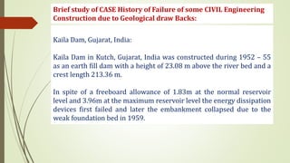
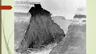
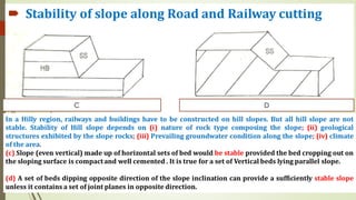
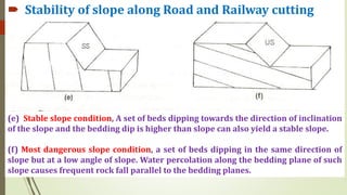
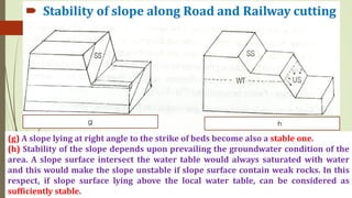
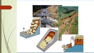
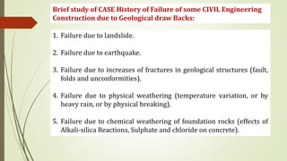
Why is Engineering Geology important for civil engineering ?
Engineering Geology is the most promising branch of geology
in terms of operational use of geological information.
Engineering geologists provide geological and geotechnical
analyses, recommendations, and design correlations with
human development and diverse structures such as bridges,
dams, tunnels, and other constructions (roads, buildings).
Why is Engineering Geology important for civil engineering ?
Engineering Geology is the application of the geological
sciences to engineering projects.
Engineering Geological analysis is also done during post-
construction and forensic phases of the projects.
The purpose of geology research is to ensure that the
geological element geological factors pertaining to designs,
constructions, sites (locations), operations, and
maintenance of engineering works are suitable for the
project implementation.
Why is Engineering Geology important for civil engineering ?
Engineering Geology knowledge is necessary in connection
with excavation works, water supply, irrigation, foundation
problems of dams, bridges, buildings and many other
purposes.
The lessons learned from Engineering Geology deals with the
application of geological knowledge in the field of civil
engineering for execution of safe, stable and cost-effective
constructions like dams, bridges and tunnels.
Engineering Geology & Civil Engineering in Construction Jobs
• In all types of heavy construction jobs such as Buildings, Towers,
Tanks, Dams and Reservoir, Highway, Bridges, Traffic and
Hydropower Tunnels etc. full geological information about the
site of Construction (or Excavation) and about the natural materials
of construction is paramount importance.
Brief study of CASE History of Failure of some CIVIL Engineering
Construction due to Geological draw Backs:
Kaila Dam, Gujarat, India:
Kaila Dam in Kutch, Gujarat, India was constructed during 1952 – 55
as an earth fill dam with a height of 23.08 m above the river bed and a
crest length 213.36 m.
In spite of a freeboard allowance of 1.83m at the normal reservoir
level and 3.96m at the maximum reservoir level the energy dissipation
devices first failed and later the embankment collapsed due to the
weak foundation bed in 1959.
Brief study of CASE History of Failure of some CIVIL Engineering
Construction due to Geological draw Backs:
Brief study of CASE History of Failure of some CIVIL Engineering
Construction due to Geological draw Backs:
Baldwin Dam (USA):
The earthen dam of height 80 m, was constructed for water supply,
with its main earthen embankment at northern end of the reservoir,
and the five minor ones to cover low lying areas along the perimeter.
The failure occurred at the northern embankment portion, adjacent to
the spillway (indicated a gradual determination of the foundation
during the life of the structure) over one of the fault zones.
• Stability
• Economy
• Safety
Geological investigations for Site selections
The main objective of geological investigations for Engineering
projects is to determine: Geological structure of the area,
Lithology of the area, Groundwater condition of the area and
the seismicity of the region.
Lithological details revealed by these investigations would
include the type of rock that make up different parts of the
area.
The geological structure of the area, which also includes
topography and geomorphology, is determined by conducting
extensive and intensive geological surveys.
Selection of Tunnel site
Selection of excavation method
Selection of design for tunnel
Assessment of cost and stability
Assessment of environment hazard
 Site Selection for Tunnel
(a) Tunnel is running parallel to bedding plane (horizontal, vertical,
or inclined) may consider safe and favourable condition where
vertical pressure on tunnel would be uniformed everywhere. It is
strong enough to withstand the overburden.
(C) Dipping bedding planes, Horizontal tunnel running
perpendicular to the strike. Over all pressure condition on the tunnel
would be quite variable. There may be longitudinal thrust due to
inclined bed in direction of tunnel which would be unhappy condition
(b) Horizontal tunnel parallel to strike of a set of inclined beds,
pressure will concentrate on the lateral side of the tunnel.
(d) Tunnel across the vertical beds, heavy pressure will concentrate
on arched roof of the tunnel.
(e) Antiformal fold and (f) Synformal fold
A tunnel may cross a set of folded beds parallel to fold axis.
Synformal fold, more lateral pressure on two sides of the tunnels.
Consider stable and safe as uniform vertical pressure.
Tunnel driven across the fold axis passing through different types of
rocks faces non uniform vertical pressure.
(g) Antiformal fold: layers are folding outwards.
Lateral pressure would be maximum at the entrance and exit point
(h) Synformal fold: Lateral Pressure at the central part of the tunnel
Both the cases Tunnelling is Unfavourable condition
 Purpose of Dams
Generation of hydropower energy
Providing water for irrigation facilities
Providing water supply for domestic consumption and industrial use
Fighting droughts and controlling floods
Providing navigational facilities
Additional benefits of fisheries and recreational facilities and
greenery along reservoir
 Site selection for Dams
Economic point of view:
• Suitable foundation must be available.
• Length of the Dam should be as small as possible, and for given height, it
should store the maximum volume of water.
• Material require d for the construction of Dam should be easily
available, either locally or the near vicinity.
• The value of land and property submerged by the proposed Dam should
be as low as possible.
• The Dam site should be easily accessible, so that it can be economically
connected to important towns and cities.
• Site for establishing labour colonies and a healthy environment should
be available near the site.
Compact sandstone may be selected for foundation rock but that case the attitude of
the beds should be considered carefully because the strength of rock and its water
tightness depends largely on the orientation of beds in respect to DAM.
(a) Beds dipping upstream 10 – 30 degree, resultant force lie right angle to bedding.
(b) Horizontal beds may preferred provided topmost bed sufficiently compact
 Site selection for Dams
Foundation Rock: Granite, Dolerite, Granitic gneiss, Quartzite,
Diorite, Compact Sandstone
Basalt, Limestone, Marble have high compressive strength, But
they cannot act as suitable foundation rock.
1. Basalt is not suitable as foundation rock as it is porous
(vesicle present within it).
2. Highly foliated schistose rock should be avoided.
3. Finely laminated sedimentary rock (shale, argillite, porous
sandstone, conglomerate) should be avoided (allow lot of
water to percolate).
4. Limestone and Marble are chemically susceptible so avoided
(gradually remove through solution leaving pores within rocks)
5. Basic rock should be avoided as it contains unstable,
chemically susceptible minerals present
Compact sandstone may be selected for foundation rock but its water tightness
depends largely on the orientation of beds in respect to DAM.
(c) Vertical beds are not very suitable because in that case bedding planes and
vertical force become parallel to each other.
(d) Most dangerous condition, acting force and bedding plane run parallel resulting
displacement and failure of dam.
Surface Topography:
The site should provide a large area for storage of
the water. Also there should be suitable routes
available for pipelines.
Sub-surface Geology:
The site must provide:
safe foundation for dam structures
Water tightness against seepage
Absence of objectionable soluble materials
Availability of local construction materials
 Site Selection for Reservoirs
 Stability and success of Reservoirs
Success of a reservoirs depends upon water tightness, rate of
siltation within reservoir. If there is excessive leakage and loss of
reservoir water then main purpose of construction remain
unfulfilled.
Excessive siltation within reservoir causes decreases of capacity of
holding water and reservoir fails to function properly as flood
controller.
Water Leakage:
(i) Reservoir standing on a horizontal bed could be favourable
where water leakage minimum and top most bed is impervious
and sufficiently compact.
(ii) Sedimentary bed or set of joint dipping upstream would be
minimum chance of loss of water from reservoir.
(iii) Large scale water leakage will take place where beds/joints
are found dipping down stream or vertical and hence such
condition is the most unfavourable.
• Topography
• Lithology
Consolidated Ground
Unconsolidated Ground
• Geological structures
Dip and Strike
Parallel to dip –safe
Perpendicular to dip-Unsafe
Angular to Dip-Unsafe
Precautions: Strong retaining wall
Good Drainage system
Enlarging the section to cutting to stable limit
• Joints
• Faults
• Ground water conditions
• Weathering
 Site Selection for Highways
 Stability of slope along Road and Railway cutting
In a Hilly region, railways and buildings have to be constructed on hill slopes. But all hill slope are not
stable. Stability of Hill slope depends on (i) nature of rock type composing the slope; (ii) geological
structures exhibited by the slope rocks; (iii) Prevailing groundwater condition along the slope; (iv) climate
of the area.
(a)Unconsolidated or semi consolidated material cannot stand on the hill slope. Slope inclination exceeds
the value of its angle of repose. Extremely dangerous and liable to frequent landslide.
(b) Slope can be stabilized by three ways: (i) Construction of some drainage cannel along the slope so that
proportion of percolation of water be minimized; (ii) reduce angle of slope by cutting slope backward ;
(iii) proper plantation.
 Stability of slope along Road and Railway cutting
(e) Stable slope condition, A set of beds dipping towards the direction of inclination
of the slope and the bedding dip is higher than slope can also yield a stable slope.
(f) Most dangerous slope condition, a set of beds dipping in the same direction of
slope but at a low angle of slope. Water percolation along the bedding plane of such
slope causes frequent rock fall parallel to the bedding planes.
(g) A slope lying at right angle to the strike of beds become also a stable one.
(h) Stability of the slope depends upon prevailing the groundwater condition of the
area. A slope surface intersect the water table would always saturated with water
and this would make the slope unstable if slope surface contain weak rocks. In this
respect, if slope surface lying above the local water table, can be considered as
sufficiently stable.
 Stability of slope along Road and Railway cutting
Landslides:
• Landslide refers to downward sliding of huge quantities of land masses.
• Often, loose and unconsolidated surficial material undergoes sliding.
• Debris slides, rock slides and rock falls are important types of
landslides.
• Debris slides are failures of unconsolidated material on the surface of
rupture.
• Rock slides are movements of essentially consolidated material of
recently detached bedrock.
Causes of Landslides
• Geological weak material
• Erosion
• Intense Rainfall
• Human excavation
• Earthquake shaking
• Volcanic eruption
Brief study of CASE History of Failure of some CIVIL Engineering
Construction due to Geological draw Backs:
1. Failure due to landslide.
2. Failure due to earthquake.
3. Failure due to increases of fractures in geological structures (fault,
folds and unconformities).
4. Failure due to physical weathering (temperature variation, or by
heavy rain, or by physical breaking).
5. Failure due to chemical weathering of foundation rocks (effects of
Alkali-silica Reactions, Sulphate and chloride on concrete).
FINITE SLOPE
Normally, when values of H
(critical) approaches the height of the
slope, the slope may generally be
considered finite
Finite assumptions are made about
the general shape of the surface of
potential failure. Cullman (1875)
approximated the surface of potential
failure as a plane.
Fig.1: Analysis of Finite Slope[Culmaan,(1875)]
Cullman's analysis is based on the
assumption that the failure of slope
occurs along a plane when the
average shearing stress tending to
cause slip is more than the shear
strength of the slope material.
Also most critical plane is the one
that has a minimum ratio of the
average shearing stress that tends to
cause failure to the shear strength of
slope material.
Fig.1: Analysis of Finite Slope[Cullmaan,(1875)]
STABILITY OF INFINITE SLOPE
The shear strength of the rock material will be
ρf = c’ + σ’ tan φ’
Considering, pore water pressure zero, we will
evaluate the FOS against a possible failure along a
plane AB located at a depth ‘H’ below the ground
surface. The slope failure can occur by the movement
of rock/soil above the plane AB from right to left.

Engineering Geology for Civil Engineering

  • 1.
    Why is EngineeringGeology important for civil engineering ? Engineering Geology is the most promising branch of geology in terms of operational use of geological information. Engineering geologists provide geological and geotechnical analyses, recommendations, and design correlations with human development and diverse structures such as bridges, dams, tunnels, and other constructions (roads, buildings).
  • 2.
    Why is EngineeringGeology important for civil engineering ? Engineering Geology is the application of the geological sciences to engineering projects. Engineering Geological analysis is also done during post- construction and forensic phases of the projects. The purpose of geology research is to ensure that the geological element geological factors pertaining to designs, constructions, sites (locations), operations, and maintenance of engineering works are suitable for the project implementation.
  • 3.
    Why is EngineeringGeology important for civil engineering ? Engineering Geology knowledge is necessary in connection with excavation works, water supply, irrigation, foundation problems of dams, bridges, buildings and many other purposes. The lessons learned from Engineering Geology deals with the application of geological knowledge in the field of civil engineering for execution of safe, stable and cost-effective constructions like dams, bridges and tunnels.
  • 6.
    Engineering Geology &Civil Engineering in Construction Jobs • In all types of heavy construction jobs such as Buildings, Towers, Tanks, Dams and Reservoir, Highway, Bridges, Traffic and Hydropower Tunnels etc. full geological information about the site of Construction (or Excavation) and about the natural materials of construction is paramount importance.
  • 7.
    Brief study ofCASE History of Failure of some CIVIL Engineering Construction due to Geological draw Backs: Kaila Dam, Gujarat, India: Kaila Dam in Kutch, Gujarat, India was constructed during 1952 – 55 as an earth fill dam with a height of 23.08 m above the river bed and a crest length 213.36 m. In spite of a freeboard allowance of 1.83m at the normal reservoir level and 3.96m at the maximum reservoir level the energy dissipation devices first failed and later the embankment collapsed due to the weak foundation bed in 1959.
  • 8.
    Brief study ofCASE History of Failure of some CIVIL Engineering Construction due to Geological draw Backs:
  • 9.
    Brief study ofCASE History of Failure of some CIVIL Engineering Construction due to Geological draw Backs: Baldwin Dam (USA): The earthen dam of height 80 m, was constructed for water supply, with its main earthen embankment at northern end of the reservoir, and the five minor ones to cover low lying areas along the perimeter. The failure occurred at the northern embankment portion, adjacent to the spillway (indicated a gradual determination of the foundation during the life of the structure) over one of the fault zones.
  • 11.
  • 13.
    Geological investigations forSite selections The main objective of geological investigations for Engineering projects is to determine: Geological structure of the area, Lithology of the area, Groundwater condition of the area and the seismicity of the region. Lithological details revealed by these investigations would include the type of rock that make up different parts of the area. The geological structure of the area, which also includes topography and geomorphology, is determined by conducting extensive and intensive geological surveys.
  • 14.
    Selection of Tunnelsite Selection of excavation method Selection of design for tunnel Assessment of cost and stability Assessment of environment hazard  Site Selection for Tunnel
  • 15.
    (a) Tunnel isrunning parallel to bedding plane (horizontal, vertical, or inclined) may consider safe and favourable condition where vertical pressure on tunnel would be uniformed everywhere. It is strong enough to withstand the overburden.
  • 16.
    (C) Dipping beddingplanes, Horizontal tunnel running perpendicular to the strike. Over all pressure condition on the tunnel would be quite variable. There may be longitudinal thrust due to inclined bed in direction of tunnel which would be unhappy condition
  • 17.
    (b) Horizontal tunnelparallel to strike of a set of inclined beds, pressure will concentrate on the lateral side of the tunnel. (d) Tunnel across the vertical beds, heavy pressure will concentrate on arched roof of the tunnel.
  • 18.
    (e) Antiformal foldand (f) Synformal fold A tunnel may cross a set of folded beds parallel to fold axis. Synformal fold, more lateral pressure on two sides of the tunnels. Consider stable and safe as uniform vertical pressure.
  • 19.
    Tunnel driven acrossthe fold axis passing through different types of rocks faces non uniform vertical pressure. (g) Antiformal fold: layers are folding outwards. Lateral pressure would be maximum at the entrance and exit point (h) Synformal fold: Lateral Pressure at the central part of the tunnel Both the cases Tunnelling is Unfavourable condition
  • 20.
     Purpose ofDams Generation of hydropower energy Providing water for irrigation facilities Providing water supply for domestic consumption and industrial use Fighting droughts and controlling floods Providing navigational facilities Additional benefits of fisheries and recreational facilities and greenery along reservoir
  • 21.
     Site selectionfor Dams  Site selection for Dams Economic point of view: • Suitable foundation must be available. • Length of the Dam should be as small as possible, and for given height, it should store the maximum volume of water. • Material require d for the construction of Dam should be easily available, either locally or the near vicinity. • The value of land and property submerged by the proposed Dam should be as low as possible. • The Dam site should be easily accessible, so that it can be economically connected to important towns and cities. • Site for establishing labour colonies and a healthy environment should be available near the site.
  • 22.
    Compact sandstone maybe selected for foundation rock but that case the attitude of the beds should be considered carefully because the strength of rock and its water tightness depends largely on the orientation of beds in respect to DAM. (a) Beds dipping upstream 10 – 30 degree, resultant force lie right angle to bedding. (b) Horizontal beds may preferred provided topmost bed sufficiently compact
  • 23.
     Site selectionfor Dams  Site selection for Dams Foundation Rock: Granite, Dolerite, Granitic gneiss, Quartzite, Diorite, Compact Sandstone Basalt, Limestone, Marble have high compressive strength, But they cannot act as suitable foundation rock. 1. Basalt is not suitable as foundation rock as it is porous (vesicle present within it). 2. Highly foliated schistose rock should be avoided. 3. Finely laminated sedimentary rock (shale, argillite, porous sandstone, conglomerate) should be avoided (allow lot of water to percolate). 4. Limestone and Marble are chemically susceptible so avoided (gradually remove through solution leaving pores within rocks) 5. Basic rock should be avoided as it contains unstable, chemically susceptible minerals present
  • 24.
    Compact sandstone maybe selected for foundation rock but its water tightness depends largely on the orientation of beds in respect to DAM. (c) Vertical beds are not very suitable because in that case bedding planes and vertical force become parallel to each other. (d) Most dangerous condition, acting force and bedding plane run parallel resulting displacement and failure of dam.
  • 25.
    Surface Topography: The siteshould provide a large area for storage of the water. Also there should be suitable routes available for pipelines. Sub-surface Geology: The site must provide: safe foundation for dam structures Water tightness against seepage Absence of objectionable soluble materials Availability of local construction materials  Site Selection for Reservoirs
  • 26.
     Stability andsuccess of Reservoirs Success of a reservoirs depends upon water tightness, rate of siltation within reservoir. If there is excessive leakage and loss of reservoir water then main purpose of construction remain unfulfilled. Excessive siltation within reservoir causes decreases of capacity of holding water and reservoir fails to function properly as flood controller. Water Leakage: (i) Reservoir standing on a horizontal bed could be favourable where water leakage minimum and top most bed is impervious and sufficiently compact. (ii) Sedimentary bed or set of joint dipping upstream would be minimum chance of loss of water from reservoir. (iii) Large scale water leakage will take place where beds/joints are found dipping down stream or vertical and hence such condition is the most unfavourable.
  • 27.
    • Topography • Lithology ConsolidatedGround Unconsolidated Ground • Geological structures Dip and Strike Parallel to dip –safe Perpendicular to dip-Unsafe Angular to Dip-Unsafe Precautions: Strong retaining wall Good Drainage system Enlarging the section to cutting to stable limit • Joints • Faults • Ground water conditions • Weathering  Site Selection for Highways
  • 28.
     Stability ofslope along Road and Railway cutting
  • 29.
     Stability ofslope along Road and Railway cutting In a Hilly region, railways and buildings have to be constructed on hill slopes. But all hill slope are not stable. Stability of Hill slope depends on (i) nature of rock type composing the slope; (ii) geological structures exhibited by the slope rocks; (iii) Prevailing groundwater condition along the slope; (iv) climate of the area. (a)Unconsolidated or semi consolidated material cannot stand on the hill slope. Slope inclination exceeds the value of its angle of repose. Extremely dangerous and liable to frequent landslide. (b) Slope can be stabilized by three ways: (i) Construction of some drainage cannel along the slope so that proportion of percolation of water be minimized; (ii) reduce angle of slope by cutting slope backward ; (iii) proper plantation.
  • 31.
     Stability ofslope along Road and Railway cutting (e) Stable slope condition, A set of beds dipping towards the direction of inclination of the slope and the bedding dip is higher than slope can also yield a stable slope. (f) Most dangerous slope condition, a set of beds dipping in the same direction of slope but at a low angle of slope. Water percolation along the bedding plane of such slope causes frequent rock fall parallel to the bedding planes.
  • 32.
    (g) A slopelying at right angle to the strike of beds become also a stable one. (h) Stability of the slope depends upon prevailing the groundwater condition of the area. A slope surface intersect the water table would always saturated with water and this would make the slope unstable if slope surface contain weak rocks. In this respect, if slope surface lying above the local water table, can be considered as sufficiently stable.
  • 33.
     Stability ofslope along Road and Railway cutting
  • 34.
     Stability ofslope along Road and Railway cutting
  • 35.
     Stability ofslope along Road and Railway cutting
  • 36.
     Stability ofslope along Road and Railway cutting
  • 39.
    Landslides: • Landslide refersto downward sliding of huge quantities of land masses. • Often, loose and unconsolidated surficial material undergoes sliding. • Debris slides, rock slides and rock falls are important types of landslides. • Debris slides are failures of unconsolidated material on the surface of rupture. • Rock slides are movements of essentially consolidated material of recently detached bedrock.
  • 40.
    Causes of Landslides •Geological weak material • Erosion • Intense Rainfall • Human excavation • Earthquake shaking • Volcanic eruption
  • 42.
    Brief study ofCASE History of Failure of some CIVIL Engineering Construction due to Geological draw Backs: 1. Failure due to landslide. 2. Failure due to earthquake. 3. Failure due to increases of fractures in geological structures (fault, folds and unconformities). 4. Failure due to physical weathering (temperature variation, or by heavy rain, or by physical breaking). 5. Failure due to chemical weathering of foundation rocks (effects of Alkali-silica Reactions, Sulphate and chloride on concrete).
  • 49.
    FINITE SLOPE Normally, whenvalues of H (critical) approaches the height of the slope, the slope may generally be considered finite Finite assumptions are made about the general shape of the surface of potential failure. Cullman (1875) approximated the surface of potential failure as a plane. Fig.1: Analysis of Finite Slope[Culmaan,(1875)]
  • 50.
    Cullman's analysis isbased on the assumption that the failure of slope occurs along a plane when the average shearing stress tending to cause slip is more than the shear strength of the slope material. Also most critical plane is the one that has a minimum ratio of the average shearing stress that tends to cause failure to the shear strength of slope material. Fig.1: Analysis of Finite Slope[Cullmaan,(1875)]
  • 51.
    STABILITY OF INFINITESLOPE The shear strength of the rock material will be ρf = c’ + σ’ tan φ’ Considering, pore water pressure zero, we will evaluate the FOS against a possible failure along a plane AB located at a depth ‘H’ below the ground surface. The slope failure can occur by the movement of rock/soil above the plane AB from right to left.