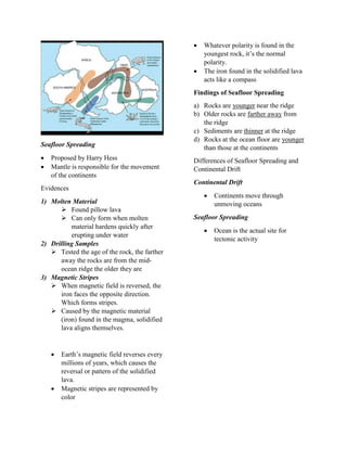
1. Earth Science
Plate Tectonics
4 layers
Inner crust
Outer crust
Mantle
Crust
Crust
Outermost layer of Earth and made
up of rocks
Extends to 32km-72 km below
Lithosphere
Consists of crust and upper mantle
Earth
Atmosphere
Hydrosphere
Lithosphere
Characteristics of Continental & Oceanic
Crust
Continental Crust Oceanic Crust
Made up of silicon,
oxygen and
aluminum, calcium,
sodium, and
potassium
Found under the
ocean floor
35-40km thick 7-10km thick,
average of 8km
thick
Made up of less
dense rocks called
granite
Made up of a dense
rock called basalt
Density of 2.7
g/cm^3
Density of 2.9
g/cm^3
Younger Older
Tectonic Plates
Theory which states that lithosphere
is divided and constantly moving.
Basis for dividing
Fault lines
Geological Activities
Major Plates Minor Plates
Eurasian Plate Caribbean Plate
North American
Plate
Philippine Plate
South American
Plate
Nazca Plate
Australia-Indo
Plate
Arabian Plate
Pacific Plate Juan de Fuca
Plate
African Plate Scotia Plate
Antarctic Plate Cocos Plate
Locating Earthquake Epicenter using
Triangulation Method
Earthquake
Result or movement of plates
Shaking of earth’s crust caused
by the release of energy
Epicenter is above the focus
Focus is where the rupture starts
Seismic Waves
Waves of energy caused by the
sudden breaking of rock within the
earth or an explosion
2 types
Body Waves
Surface Waves
2. Body Waves
Travels through the interior of the
Earth
Examples:
P Waves
S Waves
Surface Waves
Travels through the crust
Examples:
L Waves (Love Waves)
R Waves (Rayleigh Waves)
Speed Hierarchy
P Waves
S Waves
L Waves
R Waves
Seismograph
Instrument that detects earthquakes
Epicentral Distance
d= td/8 sec x 100 km
Triangulation Method
1. Check the scale on your map
2. Determine the distance to the
epicenter on your map
3. Draw a circle with a radius equal to
the number you acquired
4. Do the same for distance to the
epicenter that the other seismographs
recorded
5. All the circles should overlap. The
point where all the circle overlap is
the approximate epicenter of the
earthquake
Measurement starts at discrepancy,
whether it may be a downward or
upward amplitude
Distribution of Earthquake
Epicenters, Active Volcanoes, and
Mountain Ranges
Earthquake Locations
Found along the edges of the
continents
Mid-Continents
Oceans
Places with no earthquakes
Northernmost Area
Majority of Europe
Western Part of Africa
Eastern Portion of North and
South America
Volcanoes are found
Edges of some continents
East & South Asia
Western Coast of North & South
America
Conclusion
Earthquake Epicenters and
Volcanoes are located in the same
place
Plate boundaries vary in Mountain
Ranges
Mountain Ranges are located in
some plate boundaries
Lithosphere Division
Geological Activity in the
Location
3. Relation of Location of Epicenters, Active
Volcanoes, and Mountain Ranges
Located at the plate boundaries
Effects of movement of plates
Locations of these form plate
boundaries
Importance to know location
Avoid extensivity of probable
damage
Become more proactive
Plate Boundaries
Stress
Force acting on the unit area of a
material
Fault
Break in the earth’s crust where
significant movement has taken
place
Stress Fault Plate
Boundaries
Compressional Reverse
Fault
Convergent
Tensional Normal
Fault
Divergent
Shear Stress Strike Slip Transform
Plate boundaries are systems of
faults. All plate boundaries are faults,
but not all faults are plate
boundaries.
2 Reasons
1. Not all faults are located in the plate
boundaries
2. Not all plate boundaries are
active/inactive
Plate Tectonics
Movement of the lithosphere
Boundary Types
Transform/Strike Slip
Where plates move horizontally
against one another
Divergent/Constructive
Where plates move away from each
other
Convergent/Destructive
Plates press into one another
Plates that move with one another
Boundary Magnitude Depth
Transform <8 <25 km
Divergent <6 <10 km
Convergent <9.5 <0-700 km
Types of Convergent Subductions
Ocean Plate-Ocean Plate
Older Oceanic Plate subducts
They form:
Island Arcs
Ocean Trench
Continental Plate-Continental Plate
Mountains
Plateau
Oceanic Plate-Continental Plate
They form Volcanic Island Arcs, which
are chains of volcanoes that are parallel
to a trench
Continental Plate-Continental Plate
No subduction occurs
Mountains are formed
Crust is pushed upwards
4. Divergent/Constructive
Magma cools down, becomes part of the
crust and diverges the plate boundaries
Plates diverge 3-10 cm per year
Creates the following
New crusts
Mid-Ocean Ridge
Rift Valley
Transform/Conservative
Contact between 2 plates that slide,
which is caused by plate divergence
They create huge earthquakes/fault
systems
Earth’s Mechanisms
-Alfred Lothar Wegener (1880-1930),
proposed the Continental Drift Theory
2 reasons why it wasn’t accepted by then
Couldn’t find the reasons why the plates
move
Wegener was a meteorologist
Asthenosphere
Part of the upper mantle
Differ from lithosphere, due to
temperature
Viscoelastic
Mantle Convection
Proposed by Arthur Holmes
Holmes theorized that convection
currents move throughout the mantle the
same way heated fluids circulate in a
room.
Slab Pull Theory
Slab is pulled down from the mantle, it
drags the rest of the plate along with it
causing tectonic the movement of
tectonic plates
A very dense slab sinks faster because of
the gravitational pull
Ridge Push
Due to the elevated position of the
oceanic ridge, which cases the slabs of
the lithosphere to slide down the flanks
of the ridge
Proposed by Bott, 1991
Continental Drift Theory
Created by Alfred Wegener
Earth was once a huge landmass called
Pangaea, which is a Greek term for “all
earth”
The theory had 4 main pieces of
evidence
1. Apparent Fit of the Continents
2. Fossil Correlation
3. Rock & Mountain Correlation
4. Paleoclimate Data
Coal remains are found in the cold
regions of Earth, coal remains are the
fossil remains of tropical plants which
can’t survive cold temperatures
Glossopteris fossil is found in Australia,
Antarctica, India, South Africa, and
South America—all the southern
continents.
Lystrosaurus fossils are only found in
Antarctica, India, and South Africa.
Cynognathus was as large as a modern
wolf. Its fossils are found only in South
Africa and South America.
Mesosaurus and its remains are found
solely in South Africa and Eastern South
America.
5. Seafloor Spreading
Proposed by Harry Hess
Mantle is responsible for the movement
of the continents
Evidences
1) Molten Material
Found pillow lava
Can only form when molten
material hardens quickly after
erupting under water
2) Drilling Samples
Tested the age of the rock, the farther
away the rocks are from the mid-
ocean ridge the older they are
3) Magnetic Stripes
When magnetic field is reversed, the
iron faces the opposite direction.
Which forms stripes.
Caused by the magnetic material
(iron) found in the magma, solidified
lava aligns themselves.
Earth’s magnetic field reverses every
millions of years, which causes the
reversal or pattern of the solidified
lava.
Magnetic stripes are represented by
color
Whatever polarity is found in the
youngest rock, it’s the normal
polarity.
The iron found in the solidified lava
acts like a compass
Findings of Seafloor Spreading
a) Rocks are younger near the ridge
b) Older rocks are farther away from
the ridge
c) Sediments are thinner at the ridge
d) Rocks at the ocean floor are younger
than those at the continents
Differences of Seafloor Spreading and
Continental Drift
Continental Drift
Continents move through
unmoving oceans
Seafloor Spreading
Ocean is the actual site for
tectonic activity