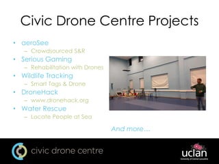
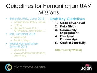
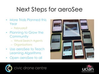
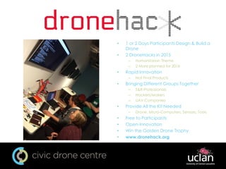
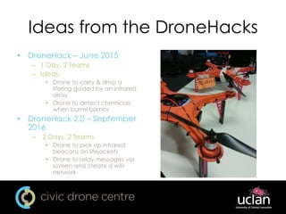
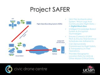
Drones for Disasters
SkyTech 2016
Andrew Heaton
27/01/2016
Introduction
• UCLan & Civic Drone Centre
• Disaster Robotics
• Current Use of Drones in Disasters
• Issues with Using Drone in Disasters
• Where Next?
• Questions
University of Central Lancashire
• UCLan
• Preston, Lancashire
– Burnley
– Westlakes
– Cyprus
– Partner Collages
• ~30,000 Students
Civic Drone Centre
• Multidisciplinary
Approach
– Collaboration
• Media Innovation Studio
• Engineering Innovation
Centre
– Other Schools
• Industry Facing
– Government, Industry
(large and small), NGOs
• CAA Training
– With The Great Circle NQE
– www.uace.uk
Civic Drone Centre Projects
• aeroSee
– Crowdsourced S&R
• Serious Gaming
– Rehabilitation with Drones
• Wildlife Tracking
– Smart Tags & Drone
• DroneHack
– www.dronehack.org
• Water Rescue
– Locate People at Sea
And more…
Disasters
• Natural
– Earthquakes
– Floods
– Volcanoes
– Fire
• Manmade
– Nuclear
– Chemical
– Fire
– Humanitarian
Disaster Robotics
• The use of robots &
remotely controlled
vehicles to aid in Disaster
Situations
– Includes Drones
– Monitoring the Situation
– Search & Rescue
• Dependent on the
Disaster
– What the Disaster is
– Environment
• Land, Sea, Urban, Rural,
Hot, Cold
Dull, Dirty & Dangerous
• Robots are Suited for DDD
Tasks
• Dull
– Long
– Monotonous
– Repetitive
• Dirty
– Nuclear
– Biological
– Chemical
• Dangerous
– Hazardous to Humans
What is Available & Uses
• Commercially Available
Drones
• Equipped with Cameras
– Optical
– Thermal Imaging
– Geo-Tagging • Aerial Perspective
– Scale
• Create Maps
– 2D, 3D
• Search & Rescue
– People Looking at the
Photos
– Computer Program
Advantages of Drones
• Can be Used:
– Before
• Mapping & Surveys of Disaster
Prone Areas
– During
• Search & Rescue, Mapping &
Survey for Situational
Awareness
– After
• Mapping & Survey,
Infrastructure Inspection
• Easy to Deploy
• Quick to Deploy
• Relatively Cheap
• Provides Up-To-Date
Information
• Publicity, Advocacy
Hebden Bridge and Mytholmroyd - 2015
Issues
• Regulations
– Different from Country to
County
• Need Training
– Use of UAVs
– S&R or Humanitarian
• Infrastructure Issues
– Power
– Communications
– Road
• Coordination of UAV Teams
– Between UAV Teams
– With Humanitarian Teams
– Government Organisations
• War Zones
• Ethics
UAViators
• Humanitarian UAV
Network
– www.uaviators.org
– Promote the use of
UAV is Humanitarian
Settings
• Coordinate UAV
Teams
– Nepal Earth Quakes
• Resources
• Organise Meetings
Guidelines for Humanitarian UAV
Missions
• Bellagio, Italy, June 2015
– International Policy Forum
– 3 Days
– UN, Red Cross, DJI,
ICT4Peace, ,Universities…
• MIT, October 2015
– Reviewed
– Send to Orgs.
• World Humanitarian
Summit 2016
– Launched
– www.worldhumanitarians
ummit.org
Draft Key Guidelines
1. Code of Conduct
2. Data Ethics
3. Community
Engagement
4. Principled
Partnerships
5. Conflict Sensitivity
http://ow.ly/WZH3j
Other Humanitarian/S&R Efforts
• Texas A&M, Center for Robot-Assisted Search and
Rescue
– www.crasar.org
• OCHA: Unmanned Aerial Vehicles in Humanitarian
Response
– http://ow.ly/WZIOH
• FSD, Drones for Humanitarian and Environmental
Purposes
– http://drones.fsd.ch/
Where Next?
UAViators: Humanitarian UAV Policy Forum, Bellagio
Delivery Drones
• Various Projects
Underway
– Amazon Prime Air
– Matternet
– DHL
– Droneports
• New Infrastructure
– Could be Effected by
Disasters
• Uses in Disasters
– Food
– Medicine
– Information
Technology Research Directions
• Higher Autonomy &
Automation
– UAVs
– Identifications of Humans
• More Specialist UAVs
– Incorporating Specific Sensors
– Custom Hardware & Software
• Multiple UAVs
– Cooperating
– Communicating
• Collaboration with
Humanitarian and Search &
Rescue Organisation
– What needs are
– What the technology can do
Penn State
aeroSee
• Crowdsourced Search &
Rescue
– Photos Take & Tagged
with GPS
– Distributed to “Virtual
Search Agents" via the
Internet
– Tag the Photo is they See
a Person
• Use with any Drone
– Which Meet Requirements
• Design of the Year 2014
• www.aerosee.org
aeroSee Trials
• Lake District, UK, 2013
– Staged Rescue
– Proof of Concept
– Open to the Public
– Patterdale Mountain Res
– Emigs
• Sotra, Norway, 2015
– Real Search
– Closed to S&R
Professionals
– IRIS Group
– Feedback Survey
aeroSee Interface
• Yes/No
• Tap/Click to
Zoom
– Lat, Long, Alt
Next Steps for aeroSee
• More Trials Planned this
Year
– February?
• Planning to Grow the
Community
– Virtual Search Agents
– Organisations
• Use aeroSee to Teach
Learning Algorithms
• Open aeroSee to all
• 1 or 2 Days Participants Design & Build a
Drone
• 2 DroneHacks in 2015
– Humanitarian Theme
– 2 More planned for 2016
• Rapid Innovation
– Not Final Products
• Bringing Different Groups Together
– S&R Professionals
– Hackers/Makers
– UAV Companies
• Provide All the Kit Needed
– Drone, Micro-Computers, Sensors, Tools
• Free to Participants
• Open-Innovation
• Win the Golden Drone Trophy
• www.dronehack.org
Ideas from the DroneHacks
• DroneHack – June 2015
– 1 Day, 2 Teams
– Ideas:
• Drone to carry & drop a
lifering guided by an infrared
array
• Drone to detect chemicals
when barrel bombs
• DroneHack 2.0 – September
2016
– 2 Days, 2 Teams
• Drone to pick up infrared
beacons on lifejackets
• Drone to relay messages via
screen and create a wifi-
network
Project SAFER
• UAV Pilot Authentication
System, Which Logs And
Communicates Flight Data –
A Digital Black Box.
• Intelligent Knowledge Based
System & Encryption
Technologies
• Ensures Currency of UAV
Pilots & Ensures Maintenance
Schedules are Adhered to
• Can Demonstrate
Commitment to Flight Safety
& Transparency in their
Operations.
• Provides Geographic
Location Data for UAVs &
Other Mission Critical Data.
Summary
• Commercially Available Products Can be Used
– Drones
– Cameras
– Software
– Delivery???
• There are Issues
– Many similar with the rest of the industry
• UAViators
– Resources
• Guidelines on Use of Drones for Humanitarian Use
– There are some already
– World Humanitarian Summit 2016
• More aeroSee Development
– www.aerosee.org
• More DroneHacks
– Development of some of the Ideas
• Other Projects Which Could Help
– Project SAFER
– Tank Inspection – Tomorrow at 14:30
Thank You for Listening
aheaton3@uclan.ac.uk
CivicDroneCentre@uclan.ac.uk
www.uclan.ac.uk
www.civicdronecentre.org
@uclan @CivicDrone @drone_hack
#dronesforgood

Drones for Disasters

  • 1.
    Drones for Disasters SkyTech2016 Andrew Heaton 27/01/2016
  • 2.
    Introduction • UCLan &Civic Drone Centre • Disaster Robotics • Current Use of Drones in Disasters • Issues with Using Drone in Disasters • Where Next? • Questions
  • 3.
    University of CentralLancashire • UCLan • Preston, Lancashire – Burnley – Westlakes – Cyprus – Partner Collages • ~30,000 Students
  • 4.
    Civic Drone Centre •Multidisciplinary Approach – Collaboration • Media Innovation Studio • Engineering Innovation Centre – Other Schools • Industry Facing – Government, Industry (large and small), NGOs • CAA Training – With The Great Circle NQE – www.uace.uk
  • 5.
    Civic Drone CentreProjects • aeroSee – Crowdsourced S&R • Serious Gaming – Rehabilitation with Drones • Wildlife Tracking – Smart Tags & Drone • DroneHack – www.dronehack.org • Water Rescue – Locate People at Sea And more…
  • 6.
    Disasters • Natural – Earthquakes –Floods – Volcanoes – Fire • Manmade – Nuclear – Chemical – Fire – Humanitarian
  • 7.
    Disaster Robotics • Theuse of robots & remotely controlled vehicles to aid in Disaster Situations – Includes Drones – Monitoring the Situation – Search & Rescue • Dependent on the Disaster – What the Disaster is – Environment • Land, Sea, Urban, Rural, Hot, Cold
  • 8.
    Dull, Dirty &Dangerous • Robots are Suited for DDD Tasks • Dull – Long – Monotonous – Repetitive • Dirty – Nuclear – Biological – Chemical • Dangerous – Hazardous to Humans
  • 9.
    What is Available& Uses • Commercially Available Drones • Equipped with Cameras – Optical – Thermal Imaging – Geo-Tagging • Aerial Perspective – Scale • Create Maps – 2D, 3D • Search & Rescue – People Looking at the Photos – Computer Program
  • 10.
    Advantages of Drones •Can be Used: – Before • Mapping & Surveys of Disaster Prone Areas – During • Search & Rescue, Mapping & Survey for Situational Awareness – After • Mapping & Survey, Infrastructure Inspection • Easy to Deploy • Quick to Deploy • Relatively Cheap • Provides Up-To-Date Information • Publicity, Advocacy Hebden Bridge and Mytholmroyd - 2015
  • 11.
    Issues • Regulations – Differentfrom Country to County • Need Training – Use of UAVs – S&R or Humanitarian • Infrastructure Issues – Power – Communications – Road • Coordination of UAV Teams – Between UAV Teams – With Humanitarian Teams – Government Organisations • War Zones • Ethics
  • 12.
    UAViators • Humanitarian UAV Network –www.uaviators.org – Promote the use of UAV is Humanitarian Settings • Coordinate UAV Teams – Nepal Earth Quakes • Resources • Organise Meetings
  • 13.
    Guidelines for HumanitarianUAV Missions • Bellagio, Italy, June 2015 – International Policy Forum – 3 Days – UN, Red Cross, DJI, ICT4Peace, ,Universities… • MIT, October 2015 – Reviewed – Send to Orgs. • World Humanitarian Summit 2016 – Launched – www.worldhumanitarians ummit.org Draft Key Guidelines 1. Code of Conduct 2. Data Ethics 3. Community Engagement 4. Principled Partnerships 5. Conflict Sensitivity http://ow.ly/WZH3j
  • 14.
    Other Humanitarian/S&R Efforts •Texas A&M, Center for Robot-Assisted Search and Rescue – www.crasar.org • OCHA: Unmanned Aerial Vehicles in Humanitarian Response – http://ow.ly/WZIOH • FSD, Drones for Humanitarian and Environmental Purposes – http://drones.fsd.ch/
  • 15.
    Where Next? UAViators: HumanitarianUAV Policy Forum, Bellagio
  • 16.
    Delivery Drones • VariousProjects Underway – Amazon Prime Air – Matternet – DHL – Droneports • New Infrastructure – Could be Effected by Disasters • Uses in Disasters – Food – Medicine – Information
  • 17.
    Technology Research Directions •Higher Autonomy & Automation – UAVs – Identifications of Humans • More Specialist UAVs – Incorporating Specific Sensors – Custom Hardware & Software • Multiple UAVs – Cooperating – Communicating • Collaboration with Humanitarian and Search & Rescue Organisation – What needs are – What the technology can do Penn State
  • 18.
    aeroSee • Crowdsourced Search& Rescue – Photos Take & Tagged with GPS – Distributed to “Virtual Search Agents" via the Internet – Tag the Photo is they See a Person • Use with any Drone – Which Meet Requirements • Design of the Year 2014 • www.aerosee.org
  • 19.
    aeroSee Trials • LakeDistrict, UK, 2013 – Staged Rescue – Proof of Concept – Open to the Public – Patterdale Mountain Res – Emigs • Sotra, Norway, 2015 – Real Search – Closed to S&R Professionals – IRIS Group – Feedback Survey
  • 20.
    aeroSee Interface • Yes/No •Tap/Click to Zoom – Lat, Long, Alt
  • 21.
    Next Steps foraeroSee • More Trials Planned this Year – February? • Planning to Grow the Community – Virtual Search Agents – Organisations • Use aeroSee to Teach Learning Algorithms • Open aeroSee to all
  • 22.
    • 1 or2 Days Participants Design & Build a Drone • 2 DroneHacks in 2015 – Humanitarian Theme – 2 More planned for 2016 • Rapid Innovation – Not Final Products • Bringing Different Groups Together – S&R Professionals – Hackers/Makers – UAV Companies • Provide All the Kit Needed – Drone, Micro-Computers, Sensors, Tools • Free to Participants • Open-Innovation • Win the Golden Drone Trophy • www.dronehack.org
  • 23.
    Ideas from theDroneHacks • DroneHack – June 2015 – 1 Day, 2 Teams – Ideas: • Drone to carry & drop a lifering guided by an infrared array • Drone to detect chemicals when barrel bombs • DroneHack 2.0 – September 2016 – 2 Days, 2 Teams • Drone to pick up infrared beacons on lifejackets • Drone to relay messages via screen and create a wifi- network
  • 24.
    Project SAFER • UAVPilot Authentication System, Which Logs And Communicates Flight Data – A Digital Black Box. • Intelligent Knowledge Based System & Encryption Technologies • Ensures Currency of UAV Pilots & Ensures Maintenance Schedules are Adhered to • Can Demonstrate Commitment to Flight Safety & Transparency in their Operations. • Provides Geographic Location Data for UAVs & Other Mission Critical Data.
  • 25.
    Summary • Commercially AvailableProducts Can be Used – Drones – Cameras – Software – Delivery??? • There are Issues – Many similar with the rest of the industry • UAViators – Resources • Guidelines on Use of Drones for Humanitarian Use – There are some already – World Humanitarian Summit 2016 • More aeroSee Development – www.aerosee.org • More DroneHacks – Development of some of the Ideas • Other Projects Which Could Help – Project SAFER – Tank Inspection – Tomorrow at 14:30
  • 26.
    Thank You forListening aheaton3@uclan.ac.uk CivicDroneCentre@uclan.ac.uk www.uclan.ac.uk www.civicdronecentre.org @uclan @CivicDrone @drone_hack #dronesforgood