Download to read offline

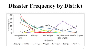
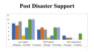

1) The document provides an overview of disasters that have occurred in Gandaki Province of Nepal. It analyzes disaster data from the province's 7 districts. 2) Unexpected higher prices, earthquakes, and droughts are the most common types of disasters experienced in the province. Nawalpur district has experienced all types of disasters. 3) Most disasters occur multiple times per year, with the highest frequency observed in 2072. Government and NGO support are the primary forms of aid after disasters.


