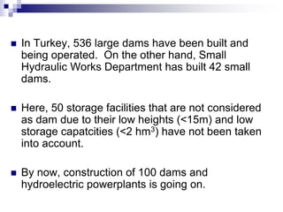
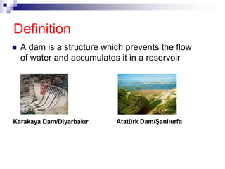
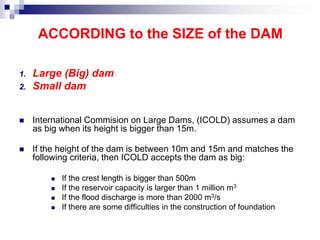
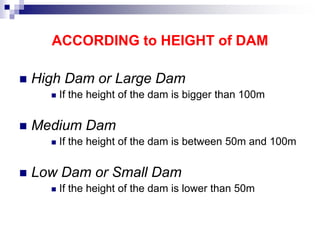
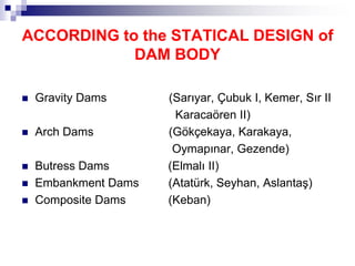
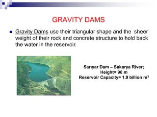
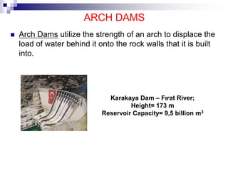
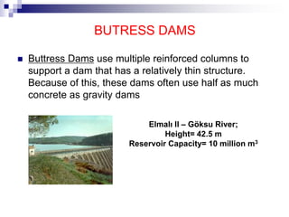
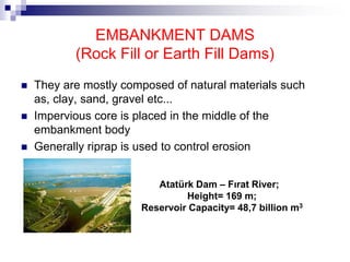
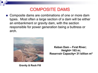
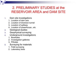
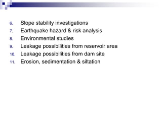
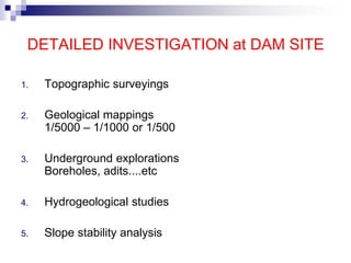
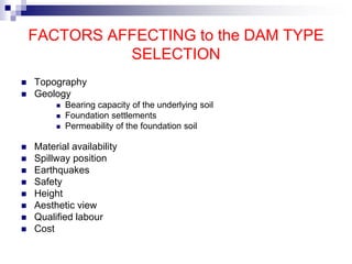
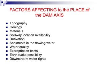
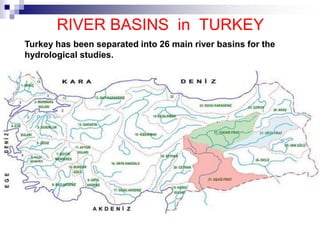
7. In Turkey, 536 large dams have been built and
being operated. On the other hand, Small
Hydraulic Works Department has built 42 small
dams.
Here, 50 storage facilities that are not considered
as dam due to their low heights (<15m) and low
storage capatcities (<2 hm3) have not been taken
into account.
By now, construction of 100 dams and
hydroelectric powerplants is going on.
8. Definition
A dam is a structure which prevents the flow
of water and accumulates it in a reservoir
Karakaya Dam/Diyarbakır Atatürk Dam/Şanlıurfa
9. Needs for Dam Construction
1. Drinking and domestic water supply
2. Flood control
3. Irrigation
4. Industrial water supply
5. Hydroelectric energy production
6. Retention and control of sediments
and Inland navigation, Improvement of water quality,
Fish Farming, Recreation facilities
12. ACCORDING to the SIZE of the DAM
1. Large (Big) dam
2. Small dam
International Commision on Large Dams, (ICOLD) assumes a dam
as big when its height is bigger than 15m.
If the height of the dam is between 10m and 15m and matches the
following criteria, then ICOLD accepts the dam as big:
If the crest length is bigger than 500m
If the reservoir capacity is larger than 1 million m3
If the flood discharge is more than 2000 m3/s
If there are some difficulties in the construction of foundation
13. ACCORDING to HEIGHT of DAM
High Dam or Large Dam
If the height of the dam is bigger than 100m
Medium Dam
If the height of the dam is between 50m and 100m
Low Dam or Small Dam
If the height of the dam is lower than 50m
14. ACCORDING to the STATICAL DESIGN of
DAM BODY
Gravity Dams (Sarıyar, Çubuk I, Kemer, Sır II
Karacaören II)
Arch Dams (Gökçekaya, Karakaya,
Oymapınar, Gezende)
Butress Dams (Elmalı II)
Embankment Dams (Atatürk, Seyhan, Aslantaş)
Composite Dams (Keban)
15. GRAVITY DAMS
Gravity Dams use their triangular shape and the sheer
weight of their rock and concrete structure to hold back
the water in the reservoir.
Sarıyar Dam – Sakarya River;
Height= 90 m
Reservoir Capacity= 1.9 billion m3
16.
17. ARCH DAMS
Arch Dams utilize the strength of an arch to displace the
load of water behind it onto the rock walls that it is built
into.
Karakaya Dam – Fırat River;
Height= 173 m
Reservoir Capacity= 9,5 billion m3
18. BUTRESS DAMS
Buttress Dams use multiple reinforced columns to
support a dam that has a relatively thin structure.
Because of this, these dams often use half as much
concrete as gravity dams
Elmalı II – Göksu River;
Height= 42.5 m
Reservoir Capacity= 10 million m3
19. EMBANKMENT DAMS
(Rock Fill or Earth Fill Dams)
They are mostly composed of natural materials such
as, clay, sand, gravel etc...
Impervious core is placed in the middle of the
embankment body
Generally riprap is used to control erosion
Atatürk Dam – Fırat River;
Height= 169 m;
Reservoir Capacity= 48,7 billion m3
20. COMPOSITE DAMS
Composite dams are combinations of one or more dam
types. Most often a large section of a dam will be either
an embankment or gravity dam, with the section
responsible for power generation being a buttress or
arch.
Keban Dam – Fırat River;
Height= 163 m;
Reservoir Capacity= 31 billion m3
Gravity & Rock Fill
22. 1. RECONNAISSANCE STUDY
1. Evaluation of the data having at archives of MTA, DSI, EIE,
Universities,......etc
2. Field investigation for limited time (Reconnaissance Study)
3. Some maps in small scale, for example 1/25.000 or 1/50.000
4. Some hydraulic data about
a. Basin
b. Precipitation area
c. Runoff, maximum discharge {Q=R/t (m3/s)}
d. Modulus of Runoff (R/t/m2 ~ R/t/km2)
5. Some approach to the reservoir area, dam site and type of dam
and height of dam...etc
6. Photogeological studies
7. A preliminary report
23. 2. PRELIMINARY STUDIES at the
RESERVOIR AREA and DAM SITE
1. Dam site investigations
1. Location of dam axis
2. Location of diversion tunnel
3. Location of spillway
4. Location of powerhouse...etc
2. Geological studies
3. Geophysical surveying
4. Underground investigations
1. Boreholes
2. Investigation galleries
3. Pitholes
5. Surveying for materials
1. Field surveying
2. Laboratory tests
24. 6. Slope stability investigations
7. Earthquake hazard & risk analysis
8. Environmental studies
9. Leakage possibilities from reservoir area
10. Leakage possibilities from dam site
11. Erosion, sedimentation & siltation
25. DETAILED INVESTIGATION at DAM SITE
1. Topographic surveyings
2. Geological mappings
1/5000 – 1/1000 or 1/500
3. Underground explorations
Boreholes, adits....etc
4. Hydrogeological studies
5. Slope stability analysis
26. FACTORS AFFECTING to the DAM TYPE
SELECTION
Topography
Geology
Bearing capacity of the underlying soil
Foundation settlements
Permeability of the foundation soil
Material availability
Spillway position
Earthquakes
Safety
Height
Aesthetic view
Qualified labour
Cost
27. FACTORS AFFECTING to the PLACE of
the DAM AXIS
Topography
Geology
Materials
Spillway location availability
Derivation
Sediments in the flowing water
Water quality
Expropriation costs
Earthquake possibility
Downstream water rights
28. RIVER BASINS in TURKEY
Turkey has been separated into 26 main river basins for the
hydrological studies.
31. ENVIRONMENTAL IMPACTS of
RESERVOIRS
Loss of land
Habitat Destruction :
The area that is covered by the reservoir is destroyed, killing
whatever habitat existed there beforehand.
Loss of archeological and histrorical places
Loss of mineral deposits
Loss of special geological formations
Aesthetic view reduction
Sedimentation
Change in river flow regime and flood effects
Reservoir induced seismicity
Change in climate and plant species
32. EFFECTS of DAMS to WATER QUALITY
Change in temperature
Turbidity
Dissolved gases in the water
Water discharged from the spillway contains 110-120%
saturated nitrogen. This amount may be destructive for fish
life.
Eutrophication
It means increase in vegetation. If moss and other plants
exist in water, quality of that water gets worse.