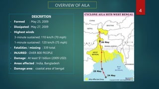
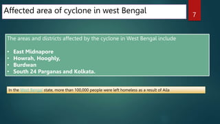
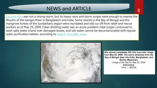
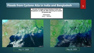
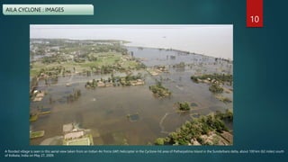
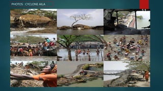
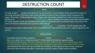
Cyclone Aila was a severe tropical cyclone that struck Bangladesh on the 25th May 2009. The cyclone's intense rainfall (120mm of rain in a few hours), very strong winds (270km/h) and large storm surge caused widespread flooding and devastation across Bangladesh.
Natural calamities do happen; disasters above certain magnitude are beyond human control. Nevertheless, mutely suffering in the PRESENT repeating the mistakes of the PAST without seeking ways and means to bring in changes for the benefit of FUTURE is meaningless.
Kerala has been hit by devastating flash flood and landslides..chandan00781
This powerpoint presentation creates on the topic of Kerala flood and it impacts on human life. This flood seriously impacts on the life cycle of Kerala people.
The Mumbai Metropolitan Region extends over an area of 4355 sq. km and comprises Municipal Corporations of Greater Mumbai, Thane, Kalyan, Navi Mumbai and Ulhasnagar; 15 municipal towns; 7 non-municipal urban centers; and 995 villages. Its administrative limits cover Mumbai City and Mumbai Suburban Districts, and parts of Thane and Raigad District. There are 40 Planning Authorities in the Region that are responsible for the micro-level planning of the different areas.
Disaster management- case study on 26 July 2005 Mumbai floodmadhura92
Presentation gives brief about Mumbai 26 July 2005 flood case study- Introduction, Factors aggravated for flood, casualty & damage, rescue operation carried out, mitigation measures, assessment done by government, guidelines for immediate action, long term strategies
A study on best practices of Water Supply infrastructures in 3 Indian cities and 2 International cities- towards the partial fulfillment of credits for the course CB1- Infrastructure and Transport Planning at the School of Planning and Architecture, New Delhi (November 2019)
types and contents for regional planning for block,district,state and nationgayathrysatheesan1
level planning framework. All planning activities at the district level will be with a single planning body at the district level. This body will be in line with Planning Boards at the state level and Planning Commission at the national level.
types and contents for regional planning for block,district,state and nation ppt
Review of Mumbai Metropolitan regional development planAnoushka Tyagi
The presentation is a Review of the Mumbai Metropolitan regional development plan with respect to the details of the districts, tehsils, population distribution & density, the content of the regional development plan document, administrative setup in the district, the chronology of earlier plans and the SWOT related to the MMR region.
Socio economic survey on siswan by charu jaiswalCharu Jaiswal
Socio economic survey on siswan of Siswan village in Kharar Tehsil of Rupnagar district in Punjab, India.I’m professional presentation maker . This document is for sale for, if required you can contact me on my gmail id bestpptmaker@gmail.com
Rapid Damage and Needs Assessment Report (RDNA), post-Cyclone Phailin in Odisha, was prepared in response to a request from the Department of Economic Affairs (DEA), Government of India (GoI). It was undertaken jointly by the Government of Odisha (GoO), the Asian Development Bank and the World Bank.
The RDNA team visited Bhubaneswar (Odisha) and the three most severely affected districts of Ganjam, Puri and Khordha, from November 26 to December 3 2013, and collaborated with the GoO to assess the damage and develop a recovery and restoration framework.
A disaster is a sudden, calamitous event that seriously disrupts the functioning of a community or society and causes human, material, and economic or environmental losses that exceed the community’s or society’s ability to cope using its own resources. Most disasters are caused by natural termed as natural disasters but sometimes they have human origins and they are called as man-made disasters
The word disaster is derived from Middle French désastre and that from Old Italian disastro, which in turn comes from the Ancient Greek pejorative prefix (dus -) "bad“ and (aster), "star". The root of the word disaster ("bad star" in Greek) comes from an astrological sense of a calamity blamed on the position of planets
A disaster is a serious disruption occurring over a short or long period of time that causes widespread human, material, economic or environmental loss which exceeds the ability of the affected community or society to cope using its own resources.
Developing countries suffer the greatest costs when a disaster hits – more than 95% of all deaths caused by hazards occur in developing countries, and losses due to natural hazards are 20 times greater (as a percentage of GDP) in developing countries than in industrialized countries
Natural disasters in Indian sub continents and India.ishu goyal
Its about the natural disasters of India and Indian sub continents as srilanka, nepal, china, etc. This will help you in getting knowledge about disasters happening near about in our neighboring countries .
ENVIRONMENT~ Renewable Energy Sources and their future prospects.tiwarimanvi3129
This presentation is for us to know that how our Environment need Attention for protection of our natural resources which are depleted day by day that's why we need to take time and shift our attention to renewable energy sources instead of non-renewable sources which are better and Eco-friendly for our environment. these renewable energy sources are so helpful for our planet and for every living organism which depends on environment.
WRI’s brand new “Food Service Playbook for Promoting Sustainable Food Choices” gives food service operators the very latest strategies for creating dining environments that empower consumers to choose sustainable, plant-rich dishes. This research builds off our first guide for food service, now with industry experience and insights from nearly 350 academic trials.
"Understanding the Carbon Cycle: Processes, Human Impacts, and Strategies for...MMariSelvam4
The carbon cycle is a critical component of Earth's environmental system, governing the movement and transformation of carbon through various reservoirs, including the atmosphere, oceans, soil, and living organisms. This complex cycle involves several key processes such as photosynthesis, respiration, decomposition, and carbon sequestration, each contributing to the regulation of carbon levels on the planet.
Human activities, particularly fossil fuel combustion and deforestation, have significantly altered the natural carbon cycle, leading to increased atmospheric carbon dioxide concentrations and driving climate change. Understanding the intricacies of the carbon cycle is essential for assessing the impacts of these changes and developing effective mitigation strategies.
By studying the carbon cycle, scientists can identify carbon sources and sinks, measure carbon fluxes, and predict future trends. This knowledge is crucial for crafting policies aimed at reducing carbon emissions, enhancing carbon storage, and promoting sustainable practices. The carbon cycle's interplay with climate systems, ecosystems, and human activities underscores its importance in maintaining a stable and healthy planet.
In-depth exploration of the carbon cycle reveals the delicate balance required to sustain life and the urgent need to address anthropogenic influences. Through research, education, and policy, we can work towards restoring equilibrium in the carbon cycle and ensuring a sustainable future for generations to come.
UNDERSTANDING WHAT GREEN WASHING IS!.pdfJulietMogola
Many companies today use green washing to lure the public into thinking they are conserving the environment but in real sense they are doing more harm. There have been such several cases from very big companies here in Kenya and also globally. This ranges from various sectors from manufacturing and goes to consumer products. Educating people on greenwashing will enable people to make better choices based on their analysis and not on what they see on marketing sites.
Epcon is One of the World's leading Manufacturing Companies.EpconLP
Epcon is One of the World's leading Manufacturing Companies. With over 4000 installations worldwide, EPCON has been pioneering new techniques since 1977 that have become industry standards now. Founded in 1977, Epcon has grown from a one-man operation to a global leader in developing and manufacturing innovative air pollution control technology and industrial heating equipment.
Improving the viability of probiotics by encapsulation methods for developmen...Open Access Research Paper
The popularity of functional foods among scientists and common people has been increasing day by day. Awareness and modernization make the consumer think better regarding food and nutrition. Now a day’s individual knows very well about the relation between food consumption and disease prevalence. Humans have a diversity of microbes in the gut that together form the gut microflora. Probiotics are the health-promoting live microbial cells improve host health through gut and brain connection and fighting against harmful bacteria. Bifidobacterium and Lactobacillus are the two bacterial genera which are considered to be probiotic. These good bacteria are facing challenges of viability. There are so many factors such as sensitivity to heat, pH, acidity, osmotic effect, mechanical shear, chemical components, freezing and storage time as well which affects the viability of probiotics in the dairy food matrix as well as in the gut. Multiple efforts have been done in the past and ongoing in present for these beneficial microbial population stability until their destination in the gut. One of a useful technique known as microencapsulation makes the probiotic effective in the diversified conditions and maintain these microbe’s community to the optimum level for achieving targeted benefits. Dairy products are found to be an ideal vehicle for probiotic incorporation. It has been seen that the encapsulated microbial cells show higher viability than the free cells in different processing and storage conditions as well as against bile salts in the gut. They make the food functional when incorporated, without affecting the product sensory characteristics.
Top 8 Strategies for Effective Sustainable Waste Management.pdfJhon Wick
Discover top strategies for effective sustainable waste management, including product removal and product destruction. Learn how to reduce, reuse, recycle, compost, implement waste segregation, and explore innovative technologies for a greener future.
different Modes of Insect Plant InteractionArchita Das
different modes of interaction between insects and plants including mutualism, commensalism, antagonism, Pairwise and diffuse coevolution, Plant defenses, how coevolution started
Presented by The Global Peatlands Assessment: Mapping, Policy, and Action at GLF Peatlands 2024 - The Global Peatlands Assessment: Mapping, Policy, and Action
Characterization and the Kinetics of drying at the drying oven and with micro...Open Access Research Paper
The objective of this work is to contribute to valorization de Nephelium lappaceum by the characterization of kinetics of drying of seeds of Nephelium lappaceum. The seeds were dehydrated until a constant mass respectively in a drying oven and a microwawe oven. The temperatures and the powers of drying are respectively: 50, 60 and 70°C and 140, 280 and 420 W. The results show that the curves of drying of seeds of Nephelium lappaceum do not present a phase of constant kinetics. The coefficients of diffusion vary between 2.09.10-8 to 2.98. 10-8m-2/s in the interval of 50°C at 70°C and between 4.83×10-07 at 9.04×10-07 m-8/s for the powers going of 140 W with 420 W the relation between Arrhenius and a value of energy of activation of 16.49 kJ. mol-1 expressed the effect of the temperature on effective diffusivity.
Characterization and the Kinetics of drying at the drying oven and with micro...
Cyclone Aila case study
1. CYCLONE: A CASE STUDY OF AILA
WEST BENGAL AND BANGLADESH
PRESENTED BY : ANAND KUMAR RAI
ROLL NO.: GEO/20/405
UNIV. ROLL NO.: 200113500006
MENTOR’S NAME: DR. SUSMITA BHOWMIK
ST. XAVIER’S COLLEGE BURDWAN
DEPARTMENT OF GEOGRAPHY
1
2. NATURAL HAZARD
Natural hazards are defined as environmental phenomena that have the potential to impact
societies and the human environment. These should not be confused with other types of hazards,
such as manmade hazards.
For example, a flood resulting from changes in river flows is a natural hazard, whereas flooding
due to a dam failure is considered a manmade hazard, and therefore excluded from the National
Risk Index.
2
3. Cyclone
In India, cyclones are classified by:
Strength of associated winds,
Storm surges
Exceptional rainfall occurrences.
Cyclones are caused by atmospheric disturbances around a low-pressure area distinguished
by swift and often destructive air circulation.
Cyclones are usually accompanied by violent storms and bad weather.
Image Source: Cyclone Aila - Wikipedia
3
4. OVERVIEW OF AILA
DESCRIPTION
• Formed : May 25, 2009
• Dissipated : May 27, 2009
• Highest winds
3-minute sustained: 110 km/h (70 mph)
1-minute sustained : 120 km/h (75 mph)
• Fatalities / missing : 339 total
• INJURED : OVER 800 PEOPLE
• Damage : At least $1 billion (2009 USD)
• Areas affected : India, Bangladesh
• Damage area : coastal area of bengal
4
5. Meteorological history
Late on May 21, 2009, the Joint Typhoon
Warning Center reported that a Tropical
Disturbance had persisted about 950 kilometres
(590 mi) to the south of Kolkata, in India and
had developed within the Southwest Monsoon.
During May 22, 2009, the disturbance
developed further with a Tropical Cyclone a
Cyclonic storm and had been named as Aila
whilst located about 350 kilometres (220 mi) to
the southeast of Sagar Island.
Aila became a severe cyclonic storm at
06UTC on May 25 and made landfall at its
peak intensity (60kt, 967hPa) between 08
and 09UTC.
The disturbance at this time had a broad and
poorly organized area of deep convection,
which was located to the southeast of the
low level circulation center which had
consolidated into a single circulation during
the previous 12 hours
5
6. PREPARATIONS
Officials in India evacuated thousands of residents from coastal areas
ahead of Cyclone Aila.
In addition, several warning alerts were issued before the cyclone
hit Kolkata; however, no alarm bells were rung.
In the Bhola District of Bangladesh, an estimated 500,000 people
evacuated to higher areas and shelters as Aila neared landfall.
Tourists were advised to stay in their hotels due to the short amount of
time to prepare for the storm.
6
7. Affected area of cyclone in west Bengal
The areas and districts affected by the cyclone in West Bengal include
• East Midnapore
• Howrah, Hooghly,
• Burdwan
• South 24 Parganas and Kolkata.
In the West Bengal state, more than 100,000 people were left homeless as a result of Aila
7
8. NEWS and ARTICLE
Cyclone Ailia was not a strong storm, but its heavy rains and storm surges were enough to swamp the
Mouths of the Ganges River in Bangladesh and India. Some islands in the Bay of Bengal and the
mangrove forests of the Sundarbans region were inundated and still cut off from relief and rescue
workers as of May 29, 2009. Clean drinking water was an acute problem: tidal surges continued to
wash salty water inland over damaged levees, and salt water cannot be decontaminated with regular
water purification tablets, according to reports from BBC news.
Aila almost completely fills this true-color image
from May 25, 2009. The storm stretches from the
Bay of Bengal deep into India, Bangladesh, and
Burma (Myanmar).
Image of the Day for May 29, 2009
Instrument:
Terra — MODIS
8
9. May 11, 2009 May 28, 2009
This pair of images shows flooding in India and
Bangladesh on May 28, 2009, following the landfall
of Cyclone Aila.
Instrument:
Aqua — MODIS
Floods from Cyclone Aila in India and Bangladesh 9
10. A flooded village is seen in this aerial view taken from an Indian Air Force (IAF) helicopter in the Cyclone-hit area of Patharpatima Island in the Sundarbans delta, about 100 km (62 miles) south
of Kolkata, India on May 27, 2009.
AILA CYCLONE : IMAGES
10
12. DESTRUCTION COUNT
INDIA
In India, at least 149 people were killed two by electrocution, and hundreds others were left homeless as
torrential rains led to flooding. High winds uprooted numerous trees, blocking roads throughout the
region.[More than 15,000 people in eight villages were reportedly isolated from relief crews by severe
flooding. At least 18 of the 45 fatalities in West Bengal were in Kolkata, the region where Aila made landfall.
All transit systems in the city of Kolkata were halted and daily life was at a standstill due to the storm.[The
areas and districts affected by the cyclone in West Bengal include East Midnapore, Howrah, Hooghly,
Burdwan, South 24 Parganas and Kolkata. In the West Bengal state, more than 100,000 people were left
homeless as a result of Aila.At least 100 river embankments were breached by storm surge produced by the
cyclone.
BANGLADESH
Torrential rains from Aila resulted in 190 fatalities and at least 7,000 injuries across
the Khulna and Satkhira Districts.Across 11 of the nation's 64 districts, approximately
600,000 thatched homes, 8,800 km (5,500 mi) of roads, 1,000 km (620 mi) of embankments, and
123,000 hectares (300,000 acres) of land were damaged or destroyed.An estimated 58,950 animals
were killed by the storm with up to 50,000 deer missing. On the island of Nizum Dwip, nearly all
structures were severely damaged or destroyed, leaving roughly 20,000 people homeless
12
13. Environmental impact ON SUNDARBANS
The Sunderbans, a region which houses 265 of the
endangered Bengal tigers, was inundated with 6.1 m
(20 ft) of water.
Dozens of the tigers are feared to have drowned in Aila's
storm surge along with deer and crocodiles.
On 27 May, conservationists have begun a search for the
tigers throughout the forest. The search teams were
supplied with fresh drinking water for the tigers as their
natural water source was inundated with salt water from
Aila's storm surge
Sundarbans National Park - Wikipedia
13
14. Table 1. Cyclone Aila-affected areas and the number of affected households. 14
15. Government Steps
• State Government in co-operation with the central counterparts
took up the rescue and the rehabilitation program. Army was
deployed to the affected areas
• The next day, the army used helicopters to provide food to the
affected population. About 2,500 troops were deployed to West
Bengal on May 26, 2009.
• Several naval relief teams were deployed to the Sunderbans region
where an estimated 400,000 people were marooned by flooding
• Roughly 100 relief camps were established in West Bengal shortly after the storm passed. On 27 May,
400 troops form the National Disaster Response Force were deployed to the state for relief
operations. The Government of India released Rs.10 million (US$209,775) in relief funds to the affected
areas on 26 May. Two MI-17 helicopters were also sent to air-drop food supplies to the worst affected
areas in West Bengal.
15
16. * Farhana S. (2011). Suitability of pond sand filters as safe drinking water solution in storm surge prone areas of bangladesh:n case
study of post-aila situation in shyamnogar, satkhira district, Khulna.
* Sharmin S.; Naznin R. (2013), Impacts of Cyclone Aila on Educational Institutions: A Study of South-Western Bangladesh.Springer.
* Mitra A; Haldar P.; Banerjee K. (2010). Changes of selected hydrological parameters in Hooghly estuary in response to a severe
tropical cyclone (Aila), Indian Jounal of Geo-Marine Sciences, Vol. 40(1). pp 32-36.
* ADRA (April 2011). Impact Evaluation of the Post Aifa Recovery Project in Sundarbans, West Bengal, India: Executive Summary.
* Hasan, M,, (july, 2010), Climate induced displacement:case study of cyclone Aila in the southwest coastal region of Bangladesh.
* Mallick, B; Rahaman K. R.; Vogt J. (2011). Coastal livelihood and physical infrastructure in Bangladesh after cyclone Aila,Springer.
References 16