QGIS with imagery satellite TMS format
•
0 likes•631 views

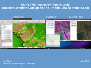
This document discusses using imagery from LANDSAT 8, RAPIDEYE, and PLANET LABS satellites in QGIS mapping software through plugins that allow accessing the imagery. It was written by Luiz Motta, a Planet Explorer Program Developer, in July 2015. The plugins mentioned provide cataloging and viewing capabilities for satellite imagery within QGIS.
Report
Share
Report
Share
Download to read offline
Recommended
CROP PRODUCTION AND MANAGEMENT
VERY ATTRACTIVE PRESENTATION CONTAINING THE FOLLOWING SLIDES: Agriculture, Crops, , Agricultural practices, Irrigation, Water logging, Weeding, Storage, Mixed Cultivation and Crop Rotation, NItrogen Fixation, Nitrogen Cycle, Animal Husbandary and many more
Recommended
CROP PRODUCTION AND MANAGEMENT
VERY ATTRACTIVE PRESENTATION CONTAINING THE FOLLOWING SLIDES: Agriculture, Crops, , Agricultural practices, Irrigation, Water logging, Weeding, Storage, Mixed Cultivation and Crop Rotation, NItrogen Fixation, Nitrogen Cycle, Animal Husbandary and many more
Catalog Planet Labs Plugin for QGIS - V1
Plugin for access the imagens of Planet Labs, update for API V1.
Qgis ibama imagefootprint
This plugin create a catalog layer from directories of images, how a memory layer, where each feature has metadata and footprint of a image.
Gimp Selection Feature Plugin QGIS
Plugin for adding selected area in GIMP how a feature in memory layer.
This plugin create a memory layer, where, yours feature can come from selected area in GIMP.
Catalog on the fly: Solução aberta para utilização imediata de grande acervo ...
Apresentação do IBAMA no Geoconnect 2016 sobre o Catalog on the Fly.
Palestrante: Luiz Motta
Virtual layer for validate overlay in shapefile
Show how use VRT layer for validate overlay inside shapefile
IBAMA Plugins July/2015
Presentation about QGIS plugins created for IBAMA:
1) Toggle Active Layer
2) Catalog on the fly
3) Auxiliary Window
Large Language Models and the End of Programming
Talk by Matt Welsh at Craft Conference 2024 on the impact that Large Language Models will have on the future of software development. In this talk, I discuss the ways in which LLMs will impact the software industry, from replacing human software developers with AI, to replacing conventional software with models that perform reasoning, computation, and problem-solving.
Prosigns: Transforming Business with Tailored Technology Solutions
Unlocking Business Potential: Tailored Technology Solutions by Prosigns
Discover how Prosigns, a leading technology solutions provider, partners with businesses to drive innovation and success. Our presentation showcases our comprehensive range of services, including custom software development, web and mobile app development, AI & ML solutions, blockchain integration, DevOps services, and Microsoft Dynamics 365 support.
Custom Software Development: Prosigns specializes in creating bespoke software solutions that cater to your unique business needs. Our team of experts works closely with you to understand your requirements and deliver tailor-made software that enhances efficiency and drives growth.
Web and Mobile App Development: From responsive websites to intuitive mobile applications, Prosigns develops cutting-edge solutions that engage users and deliver seamless experiences across devices.
AI & ML Solutions: Harnessing the power of Artificial Intelligence and Machine Learning, Prosigns provides smart solutions that automate processes, provide valuable insights, and drive informed decision-making.
Blockchain Integration: Prosigns offers comprehensive blockchain solutions, including development, integration, and consulting services, enabling businesses to leverage blockchain technology for enhanced security, transparency, and efficiency.
DevOps Services: Prosigns' DevOps services streamline development and operations processes, ensuring faster and more reliable software delivery through automation and continuous integration.
Microsoft Dynamics 365 Support: Prosigns provides comprehensive support and maintenance services for Microsoft Dynamics 365, ensuring your system is always up-to-date, secure, and running smoothly.
Learn how our collaborative approach and dedication to excellence help businesses achieve their goals and stay ahead in today's digital landscape. From concept to deployment, Prosigns is your trusted partner for transforming ideas into reality and unlocking the full potential of your business.
Join us on a journey of innovation and growth. Let's partner for success with Prosigns.
Launch Your Streaming Platforms in Minutes
The claim of launching a streaming platform in minutes might be a bit of an exaggeration, but there are services that can significantly streamline the process. Here's a breakdown:
Pros of Speedy Streaming Platform Launch Services:
No coding required: These services often use drag-and-drop interfaces or pre-built templates, eliminating the need for programming knowledge.
Faster setup: Compared to building from scratch, these platforms can get you up and running much quicker.
All-in-one solutions: Many services offer features like content management systems (CMS), video players, and monetization tools, reducing the need for multiple integrations.
Things to Consider:
Limited customization: These platforms may offer less flexibility in design and functionality compared to custom-built solutions.
Scalability: As your audience grows, you might need to upgrade to a more robust platform or encounter limitations with the "quick launch" option.
Features: Carefully evaluate which features are included and if they meet your specific needs (e.g., live streaming, subscription options).
Examples of Services for Launching Streaming Platforms:
Muvi [muvi com]
Uscreen [usencreen tv]
Alternatives to Consider:
Existing Streaming platforms: Platforms like YouTube or Twitch might be suitable for basic streaming needs, though monetization options might be limited.
Custom Development: While more time-consuming, custom development offers the most control and flexibility for your platform.
Overall, launching a streaming platform in minutes might not be entirely realistic, but these services can significantly speed up the process compared to building from scratch. Carefully consider your needs and budget when choosing the best option for you.
A Sighting of filterA in Typelevel Rite of Passage
Slide deck home: https://fpilluminated.com/deck/220
Understanding Globus Data Transfers with NetSage
NetSage is an open privacy-aware network measurement, analysis, and visualization service designed to help end-users visualize and reason about large data transfers. NetSage traditionally has used a combination of passive measurements, including SNMP and flow data, as well as active measurements, mainly perfSONAR, to provide longitudinal network performance data visualization. It has been deployed by dozens of networks world wide, and is supported domestically by the Engagement and Performance Operations Center (EPOC), NSF #2328479. We have recently expanded the NetSage data sources to include logs for Globus data transfers, following the same privacy-preserving approach as for Flow data. Using the logs for the Texas Advanced Computing Center (TACC) as an example, this talk will walk through several different example use cases that NetSage can answer, including: Who is using Globus to share data with my institution, and what kind of performance are they able to achieve? How many transfers has Globus supported for us? Which sites are we sharing the most data with, and how is that changing over time? How is my site using Globus to move data internally, and what kind of performance do we see for those transfers? What percentage of data transfers at my institution used Globus, and how did the overall data transfer performance compare to the Globus users?
Enterprise Resource Planning System in Telangana
Enterprise Resource Planning System includes various modules that reduce any business's workload. Additionally, it organizes the workflows, which drives towards enhancing productivity. Here are a detailed explanation of the ERP modules. Going through the points will help you understand how the software is changing the work dynamics.
To know more details here: https://blogs.nyggs.com/nyggs/enterprise-resource-planning-erp-system-modules/
2024 RoOUG Security model for the cloud.pptx
How we've evolved the MySQL server security model from a single DBA to the cloud.
Vitthal Shirke Java Microservices Resume.pdf
Software Engineering, Software Consulting, Tech Lead, Spring Boot, Spring Cloud, Spring Core, Spring JDBC, Spring Transaction, Spring MVC, OpenShift Cloud Platform, Kafka, REST, SOAP, LLD & HLD.
Enhancing Research Orchestration Capabilities at ORNL.pdf
Cross-facility research orchestration comes with ever-changing constraints regarding the availability and suitability of various compute and data resources. In short, a flexible data and processing fabric is needed to enable the dynamic redirection of data and compute tasks throughout the lifecycle of an experiment. In this talk, we illustrate how we easily leveraged Globus services to instrument the ACE research testbed at the Oak Ridge Leadership Computing Facility with flexible data and task orchestration capabilities.
More Related Content
More from Luiz Motta
Catalog Planet Labs Plugin for QGIS - V1
Plugin for access the imagens of Planet Labs, update for API V1.
Qgis ibama imagefootprint
This plugin create a catalog layer from directories of images, how a memory layer, where each feature has metadata and footprint of a image.
Gimp Selection Feature Plugin QGIS
Plugin for adding selected area in GIMP how a feature in memory layer.
This plugin create a memory layer, where, yours feature can come from selected area in GIMP.
Catalog on the fly: Solução aberta para utilização imediata de grande acervo ...
Apresentação do IBAMA no Geoconnect 2016 sobre o Catalog on the Fly.
Palestrante: Luiz Motta
Virtual layer for validate overlay in shapefile
Show how use VRT layer for validate overlay inside shapefile
IBAMA Plugins July/2015
Presentation about QGIS plugins created for IBAMA:
1) Toggle Active Layer
2) Catalog on the fly
3) Auxiliary Window
More from Luiz Motta (13)
Catalog on the fly: Solução aberta para utilização imediata de grande acervo ...
Catalog on the fly: Solução aberta para utilização imediata de grande acervo ...
Recently uploaded
Large Language Models and the End of Programming
Talk by Matt Welsh at Craft Conference 2024 on the impact that Large Language Models will have on the future of software development. In this talk, I discuss the ways in which LLMs will impact the software industry, from replacing human software developers with AI, to replacing conventional software with models that perform reasoning, computation, and problem-solving.
Prosigns: Transforming Business with Tailored Technology Solutions
Unlocking Business Potential: Tailored Technology Solutions by Prosigns
Discover how Prosigns, a leading technology solutions provider, partners with businesses to drive innovation and success. Our presentation showcases our comprehensive range of services, including custom software development, web and mobile app development, AI & ML solutions, blockchain integration, DevOps services, and Microsoft Dynamics 365 support.
Custom Software Development: Prosigns specializes in creating bespoke software solutions that cater to your unique business needs. Our team of experts works closely with you to understand your requirements and deliver tailor-made software that enhances efficiency and drives growth.
Web and Mobile App Development: From responsive websites to intuitive mobile applications, Prosigns develops cutting-edge solutions that engage users and deliver seamless experiences across devices.
AI & ML Solutions: Harnessing the power of Artificial Intelligence and Machine Learning, Prosigns provides smart solutions that automate processes, provide valuable insights, and drive informed decision-making.
Blockchain Integration: Prosigns offers comprehensive blockchain solutions, including development, integration, and consulting services, enabling businesses to leverage blockchain technology for enhanced security, transparency, and efficiency.
DevOps Services: Prosigns' DevOps services streamline development and operations processes, ensuring faster and more reliable software delivery through automation and continuous integration.
Microsoft Dynamics 365 Support: Prosigns provides comprehensive support and maintenance services for Microsoft Dynamics 365, ensuring your system is always up-to-date, secure, and running smoothly.
Learn how our collaborative approach and dedication to excellence help businesses achieve their goals and stay ahead in today's digital landscape. From concept to deployment, Prosigns is your trusted partner for transforming ideas into reality and unlocking the full potential of your business.
Join us on a journey of innovation and growth. Let's partner for success with Prosigns.
Launch Your Streaming Platforms in Minutes
The claim of launching a streaming platform in minutes might be a bit of an exaggeration, but there are services that can significantly streamline the process. Here's a breakdown:
Pros of Speedy Streaming Platform Launch Services:
No coding required: These services often use drag-and-drop interfaces or pre-built templates, eliminating the need for programming knowledge.
Faster setup: Compared to building from scratch, these platforms can get you up and running much quicker.
All-in-one solutions: Many services offer features like content management systems (CMS), video players, and monetization tools, reducing the need for multiple integrations.
Things to Consider:
Limited customization: These platforms may offer less flexibility in design and functionality compared to custom-built solutions.
Scalability: As your audience grows, you might need to upgrade to a more robust platform or encounter limitations with the "quick launch" option.
Features: Carefully evaluate which features are included and if they meet your specific needs (e.g., live streaming, subscription options).
Examples of Services for Launching Streaming Platforms:
Muvi [muvi com]
Uscreen [usencreen tv]
Alternatives to Consider:
Existing Streaming platforms: Platforms like YouTube or Twitch might be suitable for basic streaming needs, though monetization options might be limited.
Custom Development: While more time-consuming, custom development offers the most control and flexibility for your platform.
Overall, launching a streaming platform in minutes might not be entirely realistic, but these services can significantly speed up the process compared to building from scratch. Carefully consider your needs and budget when choosing the best option for you.
A Sighting of filterA in Typelevel Rite of Passage
Slide deck home: https://fpilluminated.com/deck/220
Understanding Globus Data Transfers with NetSage
NetSage is an open privacy-aware network measurement, analysis, and visualization service designed to help end-users visualize and reason about large data transfers. NetSage traditionally has used a combination of passive measurements, including SNMP and flow data, as well as active measurements, mainly perfSONAR, to provide longitudinal network performance data visualization. It has been deployed by dozens of networks world wide, and is supported domestically by the Engagement and Performance Operations Center (EPOC), NSF #2328479. We have recently expanded the NetSage data sources to include logs for Globus data transfers, following the same privacy-preserving approach as for Flow data. Using the logs for the Texas Advanced Computing Center (TACC) as an example, this talk will walk through several different example use cases that NetSage can answer, including: Who is using Globus to share data with my institution, and what kind of performance are they able to achieve? How many transfers has Globus supported for us? Which sites are we sharing the most data with, and how is that changing over time? How is my site using Globus to move data internally, and what kind of performance do we see for those transfers? What percentage of data transfers at my institution used Globus, and how did the overall data transfer performance compare to the Globus users?
Enterprise Resource Planning System in Telangana
Enterprise Resource Planning System includes various modules that reduce any business's workload. Additionally, it organizes the workflows, which drives towards enhancing productivity. Here are a detailed explanation of the ERP modules. Going through the points will help you understand how the software is changing the work dynamics.
To know more details here: https://blogs.nyggs.com/nyggs/enterprise-resource-planning-erp-system-modules/
2024 RoOUG Security model for the cloud.pptx
How we've evolved the MySQL server security model from a single DBA to the cloud.
Vitthal Shirke Java Microservices Resume.pdf
Software Engineering, Software Consulting, Tech Lead, Spring Boot, Spring Cloud, Spring Core, Spring JDBC, Spring Transaction, Spring MVC, OpenShift Cloud Platform, Kafka, REST, SOAP, LLD & HLD.
Enhancing Research Orchestration Capabilities at ORNL.pdf
Cross-facility research orchestration comes with ever-changing constraints regarding the availability and suitability of various compute and data resources. In short, a flexible data and processing fabric is needed to enable the dynamic redirection of data and compute tasks throughout the lifecycle of an experiment. In this talk, we illustrate how we easily leveraged Globus services to instrument the ACE research testbed at the Oak Ridge Leadership Computing Facility with flexible data and task orchestration capabilities.
Globus Compute wth IRI Workflows - GlobusWorld 2024
As part of the DOE Integrated Research Infrastructure (IRI) program, NERSC at Lawrence Berkeley National Lab and ALCF at Argonne National Lab are working closely with General Atomics on accelerating the computing requirements of the DIII-D experiment. As part of the work the team is investigating ways to speedup the time to solution for many different parts of the DIII-D workflow including how they run jobs on HPC systems. One of these routes is looking at Globus Compute as a way to replace the current method for managing tasks and we describe a brief proof of concept showing how Globus Compute could help to schedule jobs and be a tool to connect compute at different facilities.
Innovating Inference - Remote Triggering of Large Language Models on HPC Clus...
Large Language Models (LLMs) are currently the center of attention in the tech world, particularly for their potential to advance research. In this presentation, we'll explore a straightforward and effective method for quickly initiating inference runs on supercomputers using the vLLM tool with Globus Compute, specifically on the Polaris system at ALCF. We'll begin by briefly discussing the popularity and applications of LLMs in various fields. Following this, we will introduce the vLLM tool, and explain how it integrates with Globus Compute to efficiently manage LLM operations on Polaris. Attendees will learn the practical aspects of setting up and remotely triggering LLMs from local machines, focusing on ease of use and efficiency. This talk is ideal for researchers and practitioners looking to leverage the power of LLMs in their work, offering a clear guide to harnessing supercomputing resources for quick and effective LLM inference.
Webinar: Salesforce Document Management 2.0 - Smarter, Faster, Better
Check out the webinar slides to learn more about how XfilesPro transforms Salesforce document management by leveraging its world-class applications. For more details, please connect with sales@xfilespro.com
If you want to watch the on-demand webinar, please click here: https://www.xfilespro.com/webinars/salesforce-document-management-2-0-smarter-faster-better/
How Recreation Management Software Can Streamline Your Operations.pptx
Recreation management software streamlines operations by automating key tasks such as scheduling, registration, and payment processing, reducing manual workload and errors. It provides centralized management of facilities, classes, and events, ensuring efficient resource allocation and facility usage. The software offers user-friendly online portals for easy access to bookings and program information, enhancing customer experience. Real-time reporting and data analytics deliver insights into attendance and preferences, aiding in strategic decision-making. Additionally, effective communication tools keep participants and staff informed with timely updates. Overall, recreation management software enhances efficiency, improves service delivery, and boosts customer satisfaction.
Globus Connect Server Deep Dive - GlobusWorld 2024
We explore the Globus Connect Server (GCS) architecture and experiment with advanced configuration options and use cases. This content is targeted at system administrators who are familiar with GCS and currently operate—or are planning to operate—broader deployments at their institution.
Developing Distributed High-performance Computing Capabilities of an Open Sci...
COVID-19 had an unprecedented impact on scientific collaboration. The pandemic and its broad response from the scientific community has forged new relationships among public health practitioners, mathematical modelers, and scientific computing specialists, while revealing critical gaps in exploiting advanced computing systems to support urgent decision making. Informed by our team’s work in applying high-performance computing in support of public health decision makers during the COVID-19 pandemic, we present how Globus technologies are enabling the development of an open science platform for robust epidemic analysis, with the goal of collaborative, secure, distributed, on-demand, and fast time-to-solution analyses to support public health.
Cyaniclab : Software Development Agency Portfolio.pdf
CyanicLab, an offshore custom software development company based in Sweden,India, Finland, is your go-to partner for startup development and innovative web design solutions. Our expert team specializes in crafting cutting-edge software tailored to meet the unique needs of startups and established enterprises alike. From conceptualization to execution, we offer comprehensive services including web and mobile app development, UI/UX design, and ongoing software maintenance. Ready to elevate your business? Contact CyanicLab today and let us propel your vision to success with our top-notch IT solutions.
First Steps with Globus Compute Multi-User Endpoints
In this presentation we will share our experiences around getting started with the Globus Compute multi-user endpoint. Working with the Pharmacology group at the University of Auckland, we have previously written an application using Globus Compute that can offload computationally expensive steps in the researcher's workflows, which they wish to manage from their familiar Windows environments, onto the NeSI (New Zealand eScience Infrastructure) cluster. Some of the challenges we have encountered were that each researcher had to set up and manage their own single-user globus compute endpoint and that the workloads had varying resource requirements (CPUs, memory and wall time) between different runs. We hope that the multi-user endpoint will help to address these challenges and share an update on our progress here.
AI Pilot Review: The World’s First Virtual Assistant Marketing Suite
AI Pilot Review: The World’s First Virtual Assistant Marketing Suite
👉👉 Click Here To Get More Info 👇👇
https://sumonreview.com/ai-pilot-review/
AI Pilot Review: Key Features
✅Deploy AI expert bots in Any Niche With Just A Click
✅With one keyword, generate complete funnels, websites, landing pages, and more.
✅More than 85 AI features are included in the AI pilot.
✅No setup or configuration; use your voice (like Siri) to do whatever you want.
✅You Can Use AI Pilot To Create your version of AI Pilot And Charge People For It…
✅ZERO Manual Work With AI Pilot. Never write, Design, Or Code Again.
✅ZERO Limits On Features Or Usages
✅Use Our AI-powered Traffic To Get Hundreds Of Customers
✅No Complicated Setup: Get Up And Running In 2 Minutes
✅99.99% Up-Time Guaranteed
✅30 Days Money-Back Guarantee
✅ZERO Upfront Cost
See My Other Reviews Article:
(1) TubeTrivia AI Review: https://sumonreview.com/tubetrivia-ai-review
(2) SocioWave Review: https://sumonreview.com/sociowave-review
(3) AI Partner & Profit Review: https://sumonreview.com/ai-partner-profit-review
(4) AI Ebook Suite Review: https://sumonreview.com/ai-ebook-suite-review
Recently uploaded (20)
Prosigns: Transforming Business with Tailored Technology Solutions
Prosigns: Transforming Business with Tailored Technology Solutions
A Sighting of filterA in Typelevel Rite of Passage
A Sighting of filterA in Typelevel Rite of Passage
Enhancing Research Orchestration Capabilities at ORNL.pdf
Enhancing Research Orchestration Capabilities at ORNL.pdf
Globus Compute wth IRI Workflows - GlobusWorld 2024
Globus Compute wth IRI Workflows - GlobusWorld 2024
Innovating Inference - Remote Triggering of Large Language Models on HPC Clus...
Innovating Inference - Remote Triggering of Large Language Models on HPC Clus...
Webinar: Salesforce Document Management 2.0 - Smarter, Faster, Better
Webinar: Salesforce Document Management 2.0 - Smarter, Faster, Better
How Recreation Management Software Can Streamline Your Operations.pptx
How Recreation Management Software Can Streamline Your Operations.pptx
Globus Connect Server Deep Dive - GlobusWorld 2024
Globus Connect Server Deep Dive - GlobusWorld 2024
Developing Distributed High-performance Computing Capabilities of an Open Sci...
Developing Distributed High-performance Computing Capabilities of an Open Sci...
Cyaniclab : Software Development Agency Portfolio.pdf
Cyaniclab : Software Development Agency Portfolio.pdf
First Steps with Globus Compute Multi-User Endpoints
First Steps with Globus Compute Multi-User Endpoints
AI Pilot Review: The World’s First Virtual Assistant Marketing Suite
AI Pilot Review: The World’s First Virtual Assistant Marketing Suite
QGIS with imagery satellite TMS format
- 1. LANDSAT 8 RAPIDEYE PLANET LABS Using TMS images by Plugins QGIS (Auxiliary Window, Catalog on The Fly and Catalog Planet Labs) Luiz Motta Planet Explorer Program Developer July, 2015