The Columbia Queen property contains four types of mineral deposits and is located 30km north of Revelstoke, BC. It consists of eleven mineral claims covering 4,753 hectares. Exploration has found copper, zinc, lead, silver, and gold mineralization at targets including the Copper Queen showing and the adjacent Mastodon deposit. Recommended exploration includes prospecting around a high-grade float sample, extending soil sampling grids, and drilling targets like the Copper Queen showing and a VTEM and soil anomaly near Mastodon. The property is available for option.
The Royalle property is located 175 km north of Vancouver in central British Columbia, near the historic Bralorne-Pioneer gold mining camp. The property consists of three contiguous mineral claims covering 2,620 hectares. Exploration over the years has identified several gold and copper-tungsten zones, including the Upper Piebiter gold zone and the Chalco copper-tungsten zone. Recent geophysical surveys have outlined structures prospective for porphyry and epithermal mineralization. The property remains underexplored and offers potential for the discovery of bulk tonnage gold deposits and porphyry-related mineralization.
Skyharbour owns several gold exploration properties in the prolific Red Lake gold camp of Ontario. The properties have potential for gold mineralization based on their proximity to producing mines and recent discoveries by other companies on adjacent lands. Skyharbour's key property, Broulan Reef, has returned encouraging drill results that are similar in grade and style to a nearby multi-million ounce deposit. Management has over 80 years of combined experience exploring and developing projects in Red Lake.
Skyharbour owns several gold exploration properties in the prolific Red Lake gold camp of Ontario. The properties have potential for high-grade gold mineralization based on their proximity to major discoveries by Goldcorp. Drilling on the Broulan Reef property has intersected gold mineralization in the same structure as the nearby Bruce Channel deposit. The McKenzie Island property also shows continuity of mineralization between properties. Skyharbour aims to explore the untapped potential of these properties through future drilling programs.
The Lekcin property is located 10 kilometres northwest of Hope, British Columbia and consists of 23 mineral tenures covering 7,289 hectares. It is adjacent to claims formerly owned by Barrick Gold Corp that contain their past-producing Giant Mascot Mine. The property has potential for nickel-copper deposits based on similar geology and mineralization to deposits found at the Giant Mascot Mine. Exploration is recommended to further explore discoveries already made on the property and conduct additional regional geochemical sampling. The Lekcin property is available for option from its four owners.
The Spius Property is located in southwestern British Columbia and hosts a significant copper anomaly within an area of porphyry copper deposits. Historic soil and drilling data uncovered a large zone of anomalous copper values over 1 km in diameter that remains open. The property has good access and infrastructure. An initial program of geological mapping and soil sampling is recommended to further define the copper anomaly and evaluate the property's potential to host a significant porphyry copper-molybdenum deposit. The property is available for option, joint venture or purchase.
The XAMA mineral property is located in central British Columbia near Fraser Lake and contains seven mineral tenures covering 3,579 hectares. Historical exploration in the 1960s and 1970s identified widespread molybdenum and copper mineralization through soil sampling and geophysical surveys. Recommended exploration includes drilling three 500-meter holes to test induced polarization anomalies identified by previous operators, as well as a modern helicopter-borne electromagnetic survey to further explore the property's potential as a major porphyry molybdenum-copper deposit. The property has excellent infrastructure and is available for option.
This document discusses the mineral deposit discovery potential of the Big Bend region of the Columbia River in British Columbia. Specifically, it summarizes two properties in the area, Columbia Belle and Columbia Queen, that show potential for zinc-lead-silver and copper-lead-zinc deposits, respectively. For both properties, the document recommends further prospecting, sampling, geophysical surveys and drilling to better define targets for mineralization.
The document discusses rare metals in British Columbia. It notes that rare metals are essential for high-tech applications but currently have limited worldwide supply, creating opportunities. BC is well-positioned geographically and geologically to become a new supplier of rare earth elements. The document outlines over 90 rare metal occurrences in BC, hosted in deposit types such as carbonatites and pegmatites. It highlights several deposits that have seen recent exploration success, including Aley and Wicheeda, which have outlined significant rare earth mineralization.
2015 Broken Hill Resources Investment Symposium - Geological Survey of New S...Symposium
"Recent Developments and mineral potential in the Murray Basin: Heavy Mineral sands and more. "
David Forster, Senior Geoscientist, Geological Survey of New South Wales.
Technical presentation at 2015 Broken Hill Resources Investment symposium.
About Canada Silver Cobalt Works Inc.
Canada Silver Cobalt’s flagship Castle mine and 78 sq. km Castle Property features strong exploration upside
for silver, cobalt, nickel, gold and copper in the prolific past producing Gowganda high-grade Silver District of
Northern Ontario. With underground access at Castle, a pilot plant to produce cobalt-rich gravity concentrates
on site, a processing facility (TTL Laboratories) in the town of Cobalt, and a proprietary hydrometallurgical
process known as Re-2OX for the creation of technical grade cobalt sulphate as well as nickel-manganesecobalt (NMC) formulations, Canada Silver Cobalt is strategically positioned to become a Canadian leader in
the silver-cobalt space.
International Montoro Resources has acquired an additional 4 caims covering 4,500 acres, due west of its Carbo group claims in the Rocky Mountain Rare Metal Belt near Prince George, British Columbia.
The document summarizes a study of the Groote Eylandt manganese orebody in Australia. The objectives of the study were to construct an accurate resource/reserve model using over 5,500 drill holes to satisfy reporting standards. Previous models were outdated and inaccurate. Key challenges included the orebody's variability and complex geological history. The new model incorporated stratigraphic units, addressed issues like downhole smearing in drilling data, used measured yield vs assumed values, and established a validated database, providing a robust foundation for ongoing mining.
The document provides an overview of mining potential and opportunities in the Philippines. It discusses the country's long history of mining dating back to the 16th century and rich diversity of metallic and non-metallic mineral resources. It highlights several major recent porphyry copper-gold discoveries, including the Far Southeast and Boyongan deposits. The minerals sector provides significant economic contributions and employment. Many areas remain underexplored and offer potential for further discoveries of copper, gold, and other mineral deposits.
This is an abstract from the 5th Annual Minerals South Conference & Tradeshow of October 2009 in Cranbrook, British Columbia.
The subject is the Wicheeda rare earth carbonatite being explored by Spectrum Mining Corp.
World-class unconformity-related uranium deposits in the Athabasca Basin of Canada formed due to the combined effects of uranium extraction from source rocks, efficient transport by oxidized, saline brines, and exceptional trapping conditions. Uranium was extracted from basement rocks like granites, metasediments, and monazite, as well as from the sandstone cover via alteration of minerals like monazite and zircon. Oxidized, sodium-calcium-rich brines transported uranium at concentrations up to 30 ppm, aided by the redox and pH conditions. Uranium was deposited where a strong redox gradient existed between oxidized sediments and organic-rich basement rocks
The document describes geochemical and geochronological analyses of volcanic rocks in the Barby Formation in southern Namibia. Key findings include:
1) The Barby Formation contains basaltic trachyandesites, trachydacites, and rhyolites with calc-alkaline geochemistry, suggesting emplacement in an active continental margin setting.
2) U-Pb dating of zircons from four samples yielded ages of 1213.7 ± 4.8 Ma for the Barby Formation and 1217 ± 3 Ma for the coeval Spes Bonasyenite.
3) Lu-Hf isotopic analyses indicate the units formed from a mixture of younger and older
This document discusses mining in the Philippines, including its history and current state. It notes that mining dates back to the 16th century and provides a significant economic contribution today. However, it also causes environmental degradation and issues with safety, processing, and community health/conditions. There are also policy issues around overlapping mining claims, revenue sharing, and outdated small-scale mining laws. The document focuses on small-scale mining by the Monte de Oro Small Scale Miners' Association, outlining their vision, mission, goals and objectives which center around responsible mining and improving livelihoods.
Philippine Mineral Exploration Perspective -
Fernando G. Sajona
General Manager
BRASS Technologies Inc.
Consulting Geologist
Edwin G. Domingo
Director for Foreign Assisted Projects
Department of Environment and Natural Resources
13-15 September 2011
Manila Philippines
The Goldenland-Plateros project is located 5 kilometers north of Fresnillo, Zacatecas, Mexico. The project consists of two gold and silver bearing veins within the Los Angeles claim that strike north-south and dip to the southwest at 45 degrees. Historical artisanal mining in the 1980s produced 259 metric tonnes averaging 1.2 g/t gold and 445 g/t silver, and 265 metric tonnes averaging 1.9 g/t gold and 645 g/t silver. The mine workings include an old shaft that is 75 meters deep and accessible via a 40-meter inclined shaft.
Mountain View Resources provides engineering, geological, and drilling services to oil companies worldwide. They have investigated the oil and gas potential in Fiji's waters utilizing geological studies. Fiji has potential source rocks and reservoirs, and over 20 identified reefal structures could each contain 270 million barrels of oil. Fiji's geology makes it prospective for oil and gas production.
Shaver Lake is a man-made lake in Fresno County, California formed by the construction of Shaver Lake Dam in 1927. The dam was built by Southern California Edison and stores water that is used by their Big Creek hydroelectric project. The town of Shaver Lake is located on the lake's shore. Before the dam was built, the area was extensively logged and had a log flume system to transport logs down the mountain. Today, the town maintains a logging theme with some buildings originally used as sawmills.
geological field report of upper dir kpk salman khan
it has made by me hope u would like it. . . i m the student of 2nd semester department of geology .shaheed benazir bhutto university sheringal dir upper . . .i would get happy on ur suggestions . .
The Krof property targets two types of mineral deposits - a volcanogenic massive sulfide (VMS) deposit hosting copper, zinc, silver and gold, and an ultramafic-hosted nickel, copper, cobalt and platinum group element deposit similar to the nearby historic Giant Mascot Mine. Exploration at Krof since the 1980s has identified VMS mineralization at the main zone with drilling intersecting up to 4.82% copper and 19.94 g/t silver. Geophysical surveys have also identified additional electromagnetic anomalies across the property that remain untested targets. The property is available for option and further exploration is recommended to test priority drill targets at the main VMS zone and electromagnetic and geochemical anomalies elsewhere that may
Atoka Gold Corporation owns the North Battle Mountain gold property in Nevada which shows potential for a large Carlin-type gold deposit. Two large gold anomalies up to 640m by 275m have been identified on the property through rock and soil sampling. Geophysical surveys found a large gravity high and resistive zones that may indicate altered and mineralized host rocks. Three drill targets have been proposed to test for a shallow open-pit deposit as well as deeper mineralization hosted in favorable limestone units below a thrust fault zone. The property is near several major gold mines and along a belt known for hosting gold deposits.
Golden Dawn Minerals Inc. is exploring several precious and base metal properties in British Columbia, Canada. The document provides details on the Wild Rose property, which contains high-grade gold and copper veins similar to the Rossland deposits. Drilling data indicates potential for expanding known veins and defining a bulk tonnage target at the Deadwood zone. The company also discusses its Boundary Falls, Royal Attwood, and other properties that show similarities to major deposits in the region.
This document provides an introduction to Conquest Resources Limited's Golden Rose Gold Mine Property. It summarizes the property's history as a former producing gold mine. It also outlines the company's management team and asset portfolio. Finally, it describes exploration opportunities at the Golden Rose mine site, including targeting extensions of known gold zones and exploring the property at a regional scale within the Emerald Lake Magnetic Anomaly.
Core Assets: Drills are turning at Laverdiere (the find of the 1970s) followe...Stephan Bogner
Today, Core Assets Corp. announced the start of its maiden 5,000 m drill program at its district-scale Blue Property (1,116 km2) within the Atlin Mining District of northwest British Columbia, Canada. Drilling has begun at the Laverdiere Skarn-Porphyry Project with up to 1,500 m at three drill locations, followed by an additional 3,500 m of drilling at the Silver Lime CRD Project, where the company discovered an unusual high number of outcropping CRD mineralization last year.
Many if not most exploration projects worldwide are going back into known areas of mineralization, or into the shadow of established mining operations. Nowadays, virtually nobody is making new, boots-on-the-ground discoveries, not to speak of establishing new mining districts.
Voisey‘s Bay was probably the largest discovery of massive sulfides we have seen globally for about 30 years – the last pure, at-surface discovery, totally unexpected. People said there was nothing there and nobody went until two prospectors did anyway. Same with Core Assets‘ Silver Lime discovery – some people told Nick not to go there. “There‘s nothing to find but slippery glaciers and hungry grizzlies!“
Nick went anyway.
The document summarizes Warrior Ventures Inc. and their McNeil Gold Property located in Northern Ontario, Canada. It describes two areas of focus - the Isadore-MicMac area, which contains over 20 gold showings over 2km by 1km, and the Bullseye area, where drilling intersected gold and copper mineralization potentially from a VMS deposit. It provides highlights of gold grades and mineralization found from past work. Warrior Ventures has completed permitting and surveys to advance the properties towards development.
Skyharbour Resources Ltd. explores for uranium in the Athabasca Basin of northern Saskatchewan and owns several uranium properties in the region. The company's properties near the Patterson Lake South discovery area have potential for high-grade uranium mineralization. Skyharbour also explores for gold in Red Lake, Ontario and owns copper-zinc and gold properties prospective for base and precious metal deposits. The company is led by an experienced management team with decades of expertise in mineral exploration.
Heraldry Gold's Whiteburn Gold Project (PDAC, June 2022)RonHawkes1
Please view my presentation on Heraldry Gold Corporation's "Whiteburn Gold Project" in Queens County, Nova Scotia.
In particular, take a look at the new plan of Whiteburn and interpretation that the mineralised package of greywackes, gold mineralised slates, and bedding-concordant gold veins have a surface extent of 2.0 km and true thickness of 1.0 km extending from the historical workings in the north to Murphy Lake in the south (slides 27-30).
Thank you for your interest!
Advancing Discovery New Craigmont Project’s High-grade Copper Potentialnicola_mining
The document provides an overview of the New Craigmont copper project located in British Columbia, Canada. Some key points:
- The project is located at the site of the historic Craigmont copper mine which operated from 1961-1982 and produced over 34 million tonnes of ore grading 1.3% copper.
- Recent drilling has intersected high-grade copper mineralization near the historic mine and in a new zone called the Embayment Zone.
- Exploration in 2023 included drilling north and east of the historic pit which revealed copper mineralization and alterations indicating the potential for a porphyry system.
- Plans for 2024 include further drilling and geophysics to explore targets in the Guichon Quartz
GreenLight exploration in Bathurst camp results in new Gold Targets and confirms high-grade silver and base metal assays. Assays include > 3g/t Au, 549 gpt Ag, 2.35%Cu, 33.90% Pb and 22.90% Zn. Two new gold discoveries were made, including a 2m quartz-arsenopyrite shear zone assaying 3.4gpt Au and arsenopyrite-bearing boulders assaying 1.7-3gpt Au. Grab samples from the Keymet mine dump contained high grades of silver, copper, lead and zinc. Future exploration plans include expanding gold showings, trenching gold targets, and drilling untested
1. The document describes the exploration and ownership history of the Caspiche porphyry Au-Cu deposit located in Chile's Maricunga belt, including work conducted by Anglo American, Newcrest, and Exeter Resource Corporation.
2. Key events include Anglo initially exploring the area from 1986-1990 and drilling 18 holes, Newcrest exploring from 1996-1998 and drilling 36 holes, and Exeter acquiring the property in 2005 and significantly expanding the resource through additional drilling.
3. As of 2009, Exeter had outlined an inferred resource at Caspiche of 19.6 million ounces of gold and 4.8 billion pounds of copper.
Lye2006TheDiscoveryHistoryNorthparkesDepositsBen Jones
The Northparkes copper-gold deposits in New South Wales, Australia were discovered in 1976-1980 through roadside auger drilling and grid-based RAB drilling programs. Production at the mine began in 1993 from open pit mining of the E22 and E27 deposits and underground mining of E26. Further deposits including E48 were discovered through magnetic and geochemical targeting programs. Exploration since 1999 by Northparkes Mines has led to four additional porphyry discoveries within 6km of existing infrastructure, extending the mine life to at least 2016.
The document summarizes a study of oolitic ironstones from the Upper Cretaceous Bad Heart Formation in northwest Alberta, Canada. Samples were analyzed using various mineralogical techniques to characterize the mineralogy and chemistry. The ooids were found to contain layers of goethite and nontronite, with vanadium concentrations up to 0.8% V2O5. Other minerals identified included pyrite, galena, sphalerite, and arsenopyrite. The results provide insights into the depositional environment and economic potential of the iron deposit.
The document describes an aerial and driving tour of the mining infrastructure around Copper Cliff in Greater Sudbury, Ontario. It highlights 8 views of major mining and mineral processing facilities visible from the roads, including active and inactive mines, smelters, refineries, slag dumps, and tailings ponds. The tour begins on Regional Road 55 and follows roads 34 and 35, passing sites like the Copper Cliff Mine headframes, smelter, nickel refinery, Clarabelle mill, slag piles, and the former Murray Mine open pit.
Seismic Reflection Surveys in Search for Iron Oxide Copper-Gold (IOCG) Depositsiosrjce
Seismic reflection method can delineate very complex geological structures hence it might be very
effective for detecting the presence of Iron Oxide Copper-Gold (IOCG) deposits. Despite this superior
attributes, there exist a real problem for exploration beyond the immediate vicinity of a known deposit. All
previous studies have focused upon high resolution detection of mineralization and the hosting structures at
mine scale. No argument for “regional” exploration have been proposed probably because a cost benefit
analysis has never be conducted at such scale to proceed with such exploration venture. In this study, we
analyze the feasibility of such regional exploration by modelling a Vulcan IOCGU deposit scenario were a 2D
seismic survey with relatively sparse source-receiver geometry was used to detect the presence of a possible
intrusive package within 2km depth range. The modelling results demonstrates that seismic reflection method
using 10m geophones and 20m shot spacing can be used to image deposit within the depth of 2km. The
presence of reflections was visibly observed especially at the edges of intrusive packages hence it is suggested
that application of seismic reflection methods perhaps will remains the best alternative and most viable method
for exploring deep seated IOCG
The geophysical survey identified several archaeological features of interest at the site in Queen Camel, Somerset. In the northern field, anomalies were detected that may be a continuation of ditched enclosures and structures surrounding a nearby Roman villa. The southern field contained evidence of ridge and furrow plowing as well as anomalies forming an elongated enclosure and smaller rectangular enclosure that appeared to respect the location of the longer enclosure. Additional linear anomalies and discrete positive anomalies detected could represent archaeological ditches, pits, and other features. The survey improves understanding of activity around the villa and will help inform development plans for the area.
The hill that made BHP AusIMM November 2011Tony Webster
The hill that made BHP was the Broken Hill in New South Wales, Australia. It contained a rich deposit of silver, lead and zinc that was discovered in 1883. This discovery led to the founding of the Broken Hill Proprietary Company (BHP) which became one of Australia's largest companies. The geology of the hill influenced the layout and development of both the mine and the city of Broken Hill. The deposit consisted of multiple ore lenses that extended over 8 km. BHP dominated mining at Broken Hill for decades but eventually withdrew in 1940 as the ore bodies became depleted. The mining legacy of BHP is still visible today through remnants of infrastructure and the slag heaps that dominate the landscape.
Similar to Columbia queen property fact sheet 20141115 (20)
The Steadfast and Reliable Bull: Taurus Zodiac Signmy Pandit
Explore the steadfast and reliable nature of the Taurus Zodiac Sign. Discover the personality traits, key dates, and horoscope insights that define the determined and practical Taurus, and learn how their grounded nature makes them the anchor of the zodiac.
Unveiling the Dynamic Personalities, Key Dates, and Horoscope Insights: Gemin...my Pandit
Explore the fascinating world of the Gemini Zodiac Sign. Discover the unique personality traits, key dates, and horoscope insights of Gemini individuals. Learn how their sociable, communicative nature and boundless curiosity make them the dynamic explorers of the zodiac. Dive into the duality of the Gemini sign and understand their intellectual and adventurous spirit.
Cover Story - China's Investment Leader - Dr. Alyce SUmsthrill
In World Expo 2010 Shanghai – the most visited Expo in the World History
https://www.britannica.com/event/Expo-Shanghai-2010
China’s official organizer of the Expo, CCPIT (China Council for the Promotion of International Trade https://en.ccpit.org/) has chosen Dr. Alyce Su as the Cover Person with Cover Story, in the Expo’s official magazine distributed throughout the Expo, showcasing China’s New Generation of Leaders to the World.
Satta matka fixx jodi panna all market dpboss matka guessing fixx panna jodi kalyan and all market game liss cover now 420 matka office mumbai maharashtra india fixx jodi panna
Call me 9040963354
WhatsApp 9040963354
IMPACT Silver is a pure silver zinc producer with over $260 million in revenue since 2008 and a large 100% owned 210km Mexico land package - 2024 catalysts includes new 14% grade zinc Plomosas mine and 20,000m of fully funded exploration drilling.
Profiles of Iconic Fashion Personalities.pdfTTop Threads
The fashion industry is dynamic and ever-changing, continuously sculpted by trailblazing visionaries who challenge norms and redefine beauty. This document delves into the profiles of some of the most iconic fashion personalities whose impact has left a lasting impression on the industry. From timeless designers to modern-day influencers, each individual has uniquely woven their thread into the rich fabric of fashion history, contributing to its ongoing evolution.
[To download this presentation, visit:
https://www.oeconsulting.com.sg/training-presentations]
This presentation is a curated compilation of PowerPoint diagrams and templates designed to illustrate 20 different digital transformation frameworks and models. These frameworks are based on recent industry trends and best practices, ensuring that the content remains relevant and up-to-date.
Key highlights include Microsoft's Digital Transformation Framework, which focuses on driving innovation and efficiency, and McKinsey's Ten Guiding Principles, which provide strategic insights for successful digital transformation. Additionally, Forrester's framework emphasizes enhancing customer experiences and modernizing IT infrastructure, while IDC's MaturityScape helps assess and develop organizational digital maturity. MIT's framework explores cutting-edge strategies for achieving digital success.
These materials are perfect for enhancing your business or classroom presentations, offering visual aids to supplement your insights. Please note that while comprehensive, these slides are intended as supplementary resources and may not be complete for standalone instructional purposes.
Frameworks/Models included:
Microsoft’s Digital Transformation Framework
McKinsey’s Ten Guiding Principles of Digital Transformation
Forrester’s Digital Transformation Framework
IDC’s Digital Transformation MaturityScape
MIT’s Digital Transformation Framework
Gartner’s Digital Transformation Framework
Accenture’s Digital Strategy & Enterprise Frameworks
Deloitte’s Digital Industrial Transformation Framework
Capgemini’s Digital Transformation Framework
PwC’s Digital Transformation Framework
Cisco’s Digital Transformation Framework
Cognizant’s Digital Transformation Framework
DXC Technology’s Digital Transformation Framework
The BCG Strategy Palette
McKinsey’s Digital Transformation Framework
Digital Transformation Compass
Four Levels of Digital Maturity
Design Thinking Framework
Business Model Canvas
Customer Journey Map
The APCO Geopolitical Radar - Q3 2024 The Global Operating Environment for Bu...APCO
The Radar reflects input from APCO’s teams located around the world. It distils a host of interconnected events and trends into insights to inform operational and strategic decisions. Issues covered in this edition include:
NIMA2024 | De toegevoegde waarde van DEI en ESG in campagnes | Nathalie Lam |...BBPMedia1
Nathalie zal delen hoe DEI en ESG een fundamentele rol kunnen spelen in je merkstrategie en je de juiste aansluiting kan creëren met je doelgroep. Door middel van voorbeelden en simpele handvatten toont ze hoe dit in jouw organisatie toegepast kan worden.
Call8328958814 satta matka Kalyan result satta guessing➑➌➋➑➒➎➑➑➊➍
Satta Matka Kalyan Main Mumbai Fastest Results
Satta Matka ❋ Sattamatka ❋ New Mumbai Ratan Satta Matka ❋ Fast Matka ❋ Milan Market ❋ Kalyan Matka Results ❋ Satta Game ❋ Matka Game ❋ Satta Matka ❋ Kalyan Satta Matka ❋ Mumbai Main ❋ Online Matka Results ❋ Satta Matka Tips ❋ Milan Chart ❋ Satta Matka Boss❋ New Star Day ❋ Satta King ❋ Live Satta Matka Results ❋ Satta Matka Company ❋ Indian Matka ❋ Satta Matka 143❋ Kalyan Night Matka..
Industrial Tech SW: Category Renewal and CreationChristian Dahlen
Every industrial revolution has created a new set of categories and a new set of players.
Multiple new technologies have emerged, but Samsara and C3.ai are only two companies which have gone public so far.
Manufacturing startups constitute the largest pipeline share of unicorns and IPO candidates in the SF Bay Area, and software startups dominate in Germany.
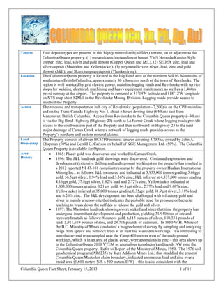
1. Columbia Queen Fact Sheet, February 15, 2013 1 of 11
Targets Four deposit types are present, in this highly mineralized (sulfides) terrane, on or adjacent to the
Columbia Queen property: (1) metavolcanic/metasediment hosted VMS Noranda/Kuroko Style
copper, zinc, lead, silver and gold deposit (Copper Queen and J&L), (2) SEDEX zinc, lead and
silver deposit (Mastodon and Yellowjacket), (3) polymetallic vein silver, lead, zinc and gold
deposit (J&L), and Skarn tungsten deposit (Thanksgiving).
Location The Columbia Queen property is located in the Big Bend area of the northern Selkirk Mountains of
southeastern British Columbia, approximately 30 kilometres north of the town of Revelstoke. The
region is well serviced by grid electric power, mainline/logging roads and Revelstoke with service
shops for welding, electrical, machining and heavy equipment maintenance as well as a 1,460m
paved runway at the airport. The property is centered at 51◦14'N latitude and 118◦12'W longitude
on NTS map sheet 82M/1 in the Revelstoke Mining Division. Logging roads provide access to
much of the Property.
Access The resource and transportation hub city of Revelstoke (population ~7,200) is on the CPR mainline
and on the Trans-Canada Highway No. 1, about 6 hours driving time (640km) east from
Vancouver, British Columbia. Access from Revelstoke to the Columbia Queen property (~30km)
is via the Big Bend Highway (Highway 23) north to La Forme Creek where logging roads provide
access to the southwestern part of the Property and then northward on Highway 23 to the next
major drainage of Carnes Creek where a network of logging roads provides access to the
Property’s northern and eastern mineral claims.
Land
Ownership
The Property consists of eleven BCMTO mineral tenures covering 4,753ha, owned by John A.
Chapman (50%) and Gerald G. Carlson on behalf of KGE Management Ltd. (50%). The Columbia
Queen Property is available for Option.
Area
History
1865: Placer gold was discovered and worked in Carnes Creek.
1896: The J&L hardrock gold showings were discovered. Continued exploration and
development (extensive drilling and underground workings) on the property has resulted in
a 2012 reported NI 43-101 compliant resource by the property owner Huakan International
Mining Inc., as follows: J&L measured and indicated at 3,953,000 tonnes grading 5.68gpt
gold, 56.5gpt silver, 1.94% lead and 3.56% zinc; J&L inferred at 4,337,000 tonnes grading
4.16gpt gold, 57.8gpt silver, 1.82% lead and 2.72% zinc; Yellowjacket indicated at
1,003,000 tonnes grading 0.21gpt gold, 64.1gpt silver, 2.77% lead and 9.08% zinc;
Yellowjacket inferred at 35,000 tonnes grading 0.35gpt gold, 81.9gpt silver, 3.18% lead
and 6.26% zinc. The J&L development has been challenged with refractory gold and
silver in mainly arsenopyrite that indicates the probable need for pressure or bacterial
leaching to break down the sulfides to release the gold and silver.
1897: The Mastodon hardrock showings were staked and since that time the property has
undergone intermittent development and production, yielding 31,940 tons of ore and
recovered metals as follows: 8 ounces gold, 6,113 ounces of silver, 180,334 pounds of
lead, 5,911,619 pounds of zinc, and 24,716 pounds of cadmium. In 1950 W.H. White of
the B.C. Ministry of Mines conducted a biogeochemical survey by sampling and analyzing
twigs from spruce and hemlock trees at an near the Mastodon workings. It is interesting to
note that several trees sampled near the Camp 400 meters west of the underground
workings, which is in an area of glacial cover, were anomalous in zinc – this area shows up
in the Columbia Queen 2010 VTEM as anomalous (conductor) and trends NW onto the
Columbia Queen property. Refer to Report of the Minister of Mines, 1950. The 1976 soil
geochemical program (AR6235) by Kerr Addison Mines Ltd., that straddled the present
Columbia Queen/Mastodon claim boundary, indicated anomalous lead and zinc over a
broad area (1,600 meters N/S x 500 meters E/W) – this is also coincident with the
2. Columbia Queen Fact Sheet, February 15, 2013 2 of 11
biogeochemical anomaly (1950) and the VTEM anomaly (2010). The Mastodon property
is owned by Teck Resources Limited.
Circa 1900 at the Copper Queen showing: The Mastodon zinc-lead-silver deposit, about
5.5 kilometers east of the Copper Queen prospect, was discovered in 1897, and prospectors
of the time probably knew of the malachite (copper oxide) stained cliff at the Copper
Queen. The first work on the Copper Queen was reported in the early 1900's, and
sometime before 1965 three drill holes tested the showings, but no records of the results of
this work were recorded.
1966 at Copper Queen: Clearwater Mines Ltd. reported (George Cross News Letter
(GCNL) No. 14, January 20, 1966) a surface channel sample across a true width of 20 feet
of exposed sulfide mineralization on the Copper Queen showings returned 1.21% copper
and 1.23% zinc. Clearwater used five diamond drill holes, totaling 1,425 feet, to test the
occurrence. Holes CQ-1 and CQ-2 were collared on a bench approximately 300 meters to
the east of the showings, but apparently failed to reach bedrock. Holes CQ-3, CQ-4, and
CQ-5 were collared at an old drill site just above the main showings and fan drilled on a
N20oW section line from a single setup. All three holes had intersections of copper and
zinc mineralization over significant core lengths. Hole CQ-3 (a vertical hole) was reported
to be well mineralized with copper (chalcopyrite) from 112 feet to about 206 feet, but only
visual estimates of grade were reported (GCNL No. 114, June 14, 1966). Hole CQ-4
contained intersections from 170 feet to 205 feet and 225 feet to 270 feet averaging 0.6%
copper and 0.47% copper, respectively (GCNL No. 131, July 8, 1966). Hole CQ-5 was
reported to contain a 98 feet section between 187 feet and 285 feet (true width reported to
be 60 feet) with grades running between 0.45% copper and 1.14% copper (GCNL No. 137,
July 18, 1966). Grid drilling, reported to be planned by Clearwater, was never undertaken.
1976 at Copper Queen: Kerr Addison Mines Ltd. held the property and conducted a
program of silt and soil sampling and geological mapping which defined a northwest-
southeast trending coincident copper, zinc and lead soil anomaly with a 600 meter length
on the CC9 claim. The anomalous trend was open to the southeast. The Copper Queen
showing was mapped as a 6 meter thick layer of calcareous metavolcanic rocks with
malachite, sphalerite, chalcopyrite, and pyrite mineralization. Kerr Addison drilled four
BQ holes totaling 775.3 meters on units 13 and 14 of the CC9 claim, but specific locations
and results were not reported (Exploration in B.C. 1977, pp. E66-E67).
1999 at Copper Queen: Orphan Boy Resources Inc. acquired the Copper Queen property
and Crest Geological Consultants Limited was retained to conduct an exploration program.
The exploration program consisted of detailed soil and rock sampling in the same area as
the 1976 Kerr Addison Mines Ltd. work on its CC9 claim. A zinc, copper and silver
anomaly was confirmed in soils, and significant zinc, copper and silver was discovered in
rock outcrops within the soil anomaly. Rock assays were as high as 7.34% zinc, >10.0%
copper (geochemical assay limit) and >99,999ppb silver (geochemical assay limit). Based
upon the 1976 and 1999 work this important metal anomaly is open to the north, northwest
and southeast.
2009 at Copper Queen: John A. Chapman and Gerald G. Carlson acquired the property,
expanded its size from 990 hectares to 4,753 hectares, and changed the name of this larger
property to Columbia Queen. In 2010 Carlson and Chapman optioned the Property to
Signature Resources Ltd. a private B.C. company. In that same year Signature
commissioned Geotech Limited to fly a helicopter-borne VTEM and Magnetic survey over
the entire Property with overlap onto adjoining areas. Significant electromagnetic (EM)
and magnetic anomalies were defined and some follow-up prospecting including soil and
rock sampling all was used to form a NI 43-101 report by Don McIntyre, Ph.D., P.Eng., in
support of an IPO and listing of Signature on the TSX Venture Exchange. During the
prospecting a high-grade float sample was found on the east side of the Property. This
sample, number CQCR06, yielded 6.12ppm gold, 0.10% copper and 0.15% lead. In
addition, a lead-in-soils anomaly was partially defined over the large 2010 EM anomaly
at/near the Mastodon claim boundary in the SE area of the Property.
3. Columbia Queen Fact Sheet, February 15, 2013 3 of 11
2012 at Columbia Queen: Signature terminated their option on the Property in November.
The Property is available for Option to Purchase.
Geology The geology of the Columbia Queen property has been mapped by Lund and Hajek (1976); Logan
et al. (1996); Logan and Rees (1997); and Payne (1999). Much of this was incorporated into a
compilation map by Logan et al. (1996a).
The Big Bend area of the Northern Selkirk Mountains, part of the eastern marginal area of the
Omineca Tectonic Belt, is situated between the fold and thrust-fault belt of the southern Canadian
Rockies on the East, and the Shuswap Metamorphic Complex in the west. The Big Bend area is
underlain by strongly deformed Neoproterozoic to Late Paleozoic metasedimentary and
metavolcanic rocks of the Kootenay Terrane which have been intruded by a number of granitic
plutons. The Shuswap Complex is separated from the rocks of the Big Bend area by the east-
dipping normal Columbia River fault zone, a major extensional fault of Eocene age.
Mineral-
ization
The British Columbia Geological Survey Branch ranks the Big Bend region among the top ten
percent in the province for metallic and industrial mineral deposit discovery potential. Significant
mineralization occurs on the Property at the Copper Queen showings (see History section above)
and on adjacent Mastodon, J&L and Thanksgiving mineral properties. See Target section above.
Potential At the west side of the Property the stratiform Copper Queen discovery (copper, zinc and
silver) is significant and based upon recent geochemical and geophysical surveys holds the
potential to be expanded into an important copper, zinc and silver deposit.
At the southeastern area of the Property the recent geophysical survey and lead-in-soils
survey indicates the potential for the Mastodon SEDEX deposit to extend onto the Property
(northwesterly direction) in an untested area covered with glacial till. Drilling here could
discover a significant zinc, lead, cadmium and silver deposit.
At the northeastern area of the Property the important J&L deposit (stratiform gold, silver,
lead and zinc) and the Yellowjacket deposit (SEDEX silver, lead and zinc) owned by
Huakan International Mining Inc. are very close to the Property boundaries. There is
ample room for discovery of similar mineralization under the extensive glacial till cover.
A float sample discovered in this area on the Property in 2010 graded 6.2gpt gold, 17.3gpt
4. Columbia Queen Fact Sheet, February 15, 2013 4 of 11
silver, 0.14% zinc, 0.10% copper and >1.0% arsenic (similar to J&L mineralization).
At the southwest corner of the Property there may be potential for a skarn tungsten
discovery as the Thanksgiving tungsten showing lies only 1,300 meters to the south.
Recom-
mended
Explor-
ation
Prospect the area where float CQCR06 was found and try to determine glacial ice
direction.
The Copper Queen soils sampling grid should be extended to the north and southeast to
more clearly define anomalous metals-in-soils discovered by Kerr Addison Mines Ltd. in
1976 (AR6235). Helicopter supported drilling could be conducted at the Copper Queen
showings to confirm and extend the copper, zinc and silver discovery made in 1966 by
Clearwater Mines Ltd.
The Southeast anomaly that is adjacent to the Mastodon deposit, and is supported by the
2010 VTEM geophysics and a 2010 metal-in-soils (mainly lead) anomaly, is drill ready
and should be tested by two fences (N60dE) of three core holes angled at 240o azimuth
and 60o dip. A 2,100 meter tote road will need be developed here for access from the
nearest logging road to the north above Carnes Creek.
Status The Columbia Queen property is available for option. Contact John A. Chapman at 604.612.9438
(jacms1@telus.net) or Gerald G. Carlson at 604.816.3012 (geraldcarlson@gmail.com).