
More Related Content
What's hot
Similar to Coastway Capability Statement
Similar to Coastway Capability Statement (20)
Coastway Capability Statement
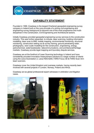
- 1. CAPABILITY STATEMENT Founded in 1999, Coastway is the largest Chartered geospatial engineering survey company in Ireland built on the core principle of a strong civil engineering and engineering survey background to become one of the most progressive and multi- disciplined in the Construction, Civil Engineering and Architectural sectors. Initially Coastway provided geospatial engineering survey services to the construction industry. This was further expanded, to include, laser scanning, building information modelling, laser scan to BIM, mobile mapping, environmental monitoring, structural monitoring, construction setting out & survey training, ground penetrating radar, photography, resin scale modelling for the construction, engineering, energy, petrochemical, water/wastewater, telecommunications, and architectural/heritage markets. Coastway provide legal mapping and boundary dispute services. Coastway are at the forefront of Laser Scanning technology in Ireland and have consistently provided innovative measurement solutions to a large number of clients using the Leica Scanstation 2, Leica HDS 6200, FARO Focus 3D & FARO Scan Arm laser scanners. Coastway cover the United Kingdom and overseas markets, having recently been involved with several projects in London, Norway, Poland and Africa. Coastway act as global professional expert witnesses in arbitration and litigation cases. 1
- 2. Our full range of professional services includes: Geospatial Engineering We offer a substantial range of Geospatial engineering and surveying services including but not limited to topographical survey, setting out, measured building surveys, nett internal area surveys, heritage surveys, highway surveys, railtrack and tunnel surveys. Laser Scanning The latest method of Geo-spatial data capture. Coastway are in the forefront of this field in Ireland. We have completed a number of high profile laser scans some of which can be viewed on our web page www.coastway.net Structural Monitoring Coastway offer a full range of services and equipment in the fields of structural monitoring including: 3-dimensional ‘real time’ structural monitoring, continuous electronic crack monitoring, Avongard ‘tell-tale crack monitoring, precise levelling, inclination and tilt monitoring. Environmental Monitoring An important aspect of every construction project. Coastway offer a full range of services and equipment in this sector, including vibration, noise and dust. We can provide a full bespoke service or hire out noise and vibration monitoring equipment. 3D Modelling & Resin Scale Models A natural follow on from our laser scanning division was to offer the service of 3D modelling in several formats/outputs e.g. 3D Studio Max, 3D rendered AutoCAD etc. Coastway also provide the ability to produce either laser scanned scale models or client delivered datasets into actual scaled resin models. Ground Penetrating Radar A rapid, cost effective and non-intrusive survey method with a wide range of applications; including service location, archaeological, structural investigations, pavement assessments and geological investigations. 2
- 3. Photography Coastway offer a full professional photography service to the Construction, Engineering & Architectural industry. We specialise in site progress photography both ground and aerial. We offer the ability to perform marketing photography, including small to large prints and a framing service. Mobile Mapping Coastway are the only geospatial engineering company in Ireland to offer this unique service. We use mobile mapping to rapidly collect geo-referenced survey data for production of complete as-built 3D models. Building Information Modelling Coastway is proud to offer Ireland’s first Laser Scan to BIM (Building Information Modelling) Service.This new service allows Clients to extract fully interactive Three-Dimensional Spatial Models from existing Sites, Buildings & Structures from the latest High- Definition Laser Scan Survey Equipment. Training Courses for the Construction Industry Coastway Training is a specialist in providing quality, flexible training courses in setting out and use of survey instruments with standard or tailor-made courses delivered on your premises or at ours. All our trainers are experts in their field with the ability to engage and inspire. Courses include levelling, setting out, GPS, monitoring from basic to advanced. Check out our webpage www.coastway.net for further details and next available courses. Legal Mapping & Boundary Disputes The policy of Coastway is to provide clients with a first class professional service based on industry best practice and codes of professional conduct. Coastway offer impartial analysis of all matters pertaining to legal mapping, measurement and boundary disputes. Based on this fundamental policy, our services will withstand and endure independent objective scrutiny. Expert Witness Coastway provides Chartered Geospatial Engineers to act as Expert Witness in all areas of geospatial engineering and construction for the successful resolution of legal disputes in adjudication, mediation, conciliation, arbitration and litigation. Coastway provide expert advice and expert reports on a global consultancy basis. 3
- 4. Profile of Mark Hudson FCInstCES MRICS ASCS ACIArb MIIS, Director 32 years professional geospatial engineering experience on major civil engineering and mining projects around the world. Chief Surveyor on Dublin Port Tunnel & LUAS Light Rail Project. Chief Circuit Engineering Surveyor for Formula One Administration (FOA & FIA) on existing & proposed Grand Prix Circuits around the world. Senior Surveyor on Jubilee Line Extension for London Underground. Senior Surveyor on Channel Tunnel for Trans-Manche Link, Tarmac Construction. Ten years working for British Coal as a senior mining surveyor involved with several collieries & major projects. Mark is currently the vice chairman of the Institution of Civil Engineering Surveyors International Affairs committee and a Fellow member of ICES Council of Management. Mark is a Chartered Surveyor with the RICS and SCS, an Associate member of the Chartered Institute of Arbitrators & also a member of the Irish Institution of Surveyors. Mark acts as expert witness on global litigation and arbitration cases. Profile of Enda Nolan BSc MICE MIEI, Director 25 years experience in the construction industry working on a variety of railway, civil & building projects, this experience has been gained in the UK, Ireland and Spain. Project management roles on major civil & railway infrastructure projects including: Jubilee Line Extension and Docklands Light Rail Projects for London Underground. Construction of Tower Block, Canary Wharf London. Supervision and management role for LUAS Light Rail Project, Dublin. Management role for Du Pont on a major power station construction project in Northern Spain. Enda is an active member of the Permanent Way Institute, Irish Region. Enda is also a member of ICES Ireland, ICE & Engineers Ireland. 4
- 5. Jeff Hott BSc, Survey & Laser Scanning Manager Jeff has in excess of ten years experience in the Survey, CAD and GIS fields. He has worked on a large number of projects in Ireland and The United States of America. His primary role within Coastway is the management of our Survey and Laser Scanning teams. His vast experience in GIS and CAD functionality has benefited our customers on numerous occasions when innovative output of data is required. Jeff continually embraces the latest technology and a strong desire to "up skill" maintains Coastway’s position in the forefront of laser scanning in Ireland. Memberships and Affiliations Coastway senior staff are professional members of the Chartered Institution of Civil Engineering Surveyors, Royal Institution of Chartered Surveyors, Society of Chartered Surveyors, Chartered Institute of Arbitrators, Institute of Civil Engineers, Engineers Ireland, Irish Institute of Surveyors, British Tunneling Society, Irish Mines & Quarries Society and the Permanent Way Society Coastway are members of Dublin Chamber of Commerce, Cork Chamber of Commerce & the Northern Ireland Chamber of Commerce. Staff are required to maintain a professional ethos across all divisions of the company. All Coastway staff have experience in their respective fields and are encouraged to undergo additional training at every opportunity to ensure a continual development of skills both individually and as a group. We have sufficient resources to cope with any survey no matter how large or small. We pride ourselves on our ability to provide a friendly, personal and professional service at all times. 5
- 6. Coastway Projects (selected) LUAS light rail projects, Dublin Dublin Port Access Tunnel M7/M9 motorway upgrade Shell Corrib terminal and onshore pipeline Dublin Metro North M7/M8 PPP motorway upgrade M1 Boyne bridge Huntstown power station Wyeth pharmaceutical project Intel FAB 24 project Dundrum shopping centre Dublin airport T2 Dublin to Cork mainline track upgrade Point Depot / O2 Arena Coastway Clients (selected) Haliburton Brown & Root Nishimatsu construction company Ltd Carillion Balfour Beatty Ferrovial Dragados Dublin Airport Authority BAM contractors Laing O’Rourke SIAC Irish Rail John Sisk Shell (SEPIL) O’Connor Sutton Cronin Irish Asphalt Intel OPW RPA Norman Foster architects Mott MacDonald Sisk Roadbridge - Poland Lagan Group Vinci Construction Roughan O’Donovan ARUP 6
- 7. Coastway Offices Head Office Coastway Survey House, Tougher Business Park, Newhall, Naas, Co. Kildare. T: +353 (0) 45 435 880 F: +353 (0) 45 437 594 E: query@coastway.net Cork Office Coastway Acorn Business Campus, Mahon Industrial Estate, Blackrock, Cork, T: +353 (0) 21 453 6138 F: +353 (0) 21 453 6139 E: cork@coastway.net Belfast Office Coastway Forsyth Business Centre, Forsyth House, Cromac Square, Belfast. BT2 8LA T: +44 2890 923 477 F: +44 2890 923 467 E: belfast@coastway.net London Office Coastway Geomatics Suite 12399 2nd Floor 145-157 St John Street London EC1V 4PY T: +44 207 6085564 E: London@coastway.net Poland Office (Partnership with Geomatics) Geomatics Tuwima 22a 76-200 SLUPSK Poland T: +48 518571071 E: biuro@geomatics.com.pl W: www.geomatics.com.pl Worldwide Services www.coastway.net 7