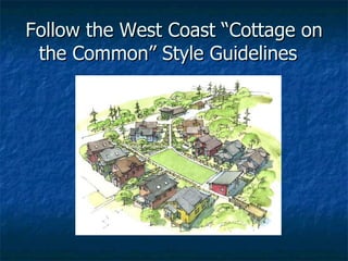
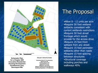
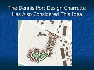
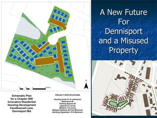
The document proposes changes to city ordinances regarding open storage, vegetation, rights-of-way, parking recreational vehicles and trucks in residential areas, and shopping carts. It outlines current ordinances, proposed changes to increase safety and address complaints, and seeks feedback. Revisions are suggested to prohibit parking commercial vehicles and recreational vehicles on lawns in residential areas. A new shopping cart ordinance is proposed requiring owner registration and recovery efforts to prevent abandoned carts. Feedback is requested on the proposed changes before next steps.
1) Ahmedabad has undertaken various initiatives to reduce its carbon footprint and promote environmental sustainability, including energy audits, recycling and reuse of treated wastewater, revitalizing water bodies, and improvements to land use planning and public transport.
2) Specific projects include installing more efficient pumps and lighting, treating 100% of sewage and maximizing reuse, and developing the Sabarmati Riverfront project to reclaim land and create parks.
3) The city's population is expected to reach over 10 million by 2031, so Ahmedabad is focusing on strengthening public transport through a bus rapid transit system and planned metro to reduce individual vehicle use and associated pollution.
Reconsider North Cowichan RCMP detachment 2020Hajo Meijer
I created this presentation for a study assignment. North Cowichan is planning to build a new RCMP facility on the edge of town on a site that is currently a farm field. I believe this is a mistake as the Cowichan Valley is already being spoiled by (sub)urban sprawl. IMO it should be planned within the existing build-up area of Duncan. Sadly, with the current situation around Covid, council is not accepting delegations, so I'm hoping to bring some awareness to the issue in this way.
The document discusses how development patterns and transportation choices in Moscow, Idaho contribute to global warming emissions and recommends actions to address this. It notes that current development patterns have created a dependence on automobiles for transportation. It advocates for revising development and zoning policies to promote more walkable and bike-friendly neighborhoods through strategies like density increases, form-based codes, adaptive reuse of buildings, and size caps on large retail developments. Community participation is urged to make changes to the comprehensive plan that support green transportation options.
120314 southpoint plaza zoning presentation final 4.23.12cityofevanston
The document proposes a plan to demolish and rebuild parts of Southpoint Plaza including a new Walgreens store. It requests a special use permit to replace an existing drive-thru with a new prescription drive-thru and a variation to allow a zero foot rear setback adjacent to an alley. The plan aims to improve site circulation, parking, landscaping, and building facades while increasing parking spaces from 80 to 83.
This document provides an overview of Agenda Item #1, which is a rezoning request for the Aspen Heights PDD. The proposed rezoning would allow for multi-family residential units with 2 to 5 bedrooms in buildings up to 40 feet tall. While the Planning & Zoning Commission recommended approval, city staff recommends denial due to concerns about traffic impacts on the existing transportation network. The applicant proposes some community benefits like road improvements and additional park funds if the rezoning is approved.
Making the Most of Build to Rent - LB Barking & Dagenham - Dubravka Polic futureoflondon
On 17 August, Future of London organised a field trip to LB Barking & Dagenham to explore three borough-led Build to Rent schemes. Dubravka Polic, Senior Regeneration Professional at LB Barking & Dagenham gave a presentation and led the visit.
Green Building Academy is the academic division of M/s Conserve Green Building & MEP Solutions, Doha, Qatar established to cater the academic needs of construction sector, especially in Green Buildings, MEP, Energy Efficiency etc.
This document provides a history of the Linden Street Commercial District in Wellesley, Massachusetts from 1876 to 2014. It discusses how the district was previously considered the town's service area, containing a lumber yard, hardware store, printing business, and car dealership. A 2001 vision and 2002-2004 master plan focused on enhancing pedestrian safety, experience, and parking while maintaining the street's character. Stakeholders expressed wanting to retain existing land uses and parking. The 18-acre area was rezoned and redeveloped starting in 2005 to create Linden Square, a retail lifestyle center, with enhancements like wider sidewalks and on-street parking to create a downtown look.
The document summarizes an application for incentives under the City's Infill Development Incentive Program by RNR Properties to develop a vacant lot at 5000 Riley Ct. into a 10-unit apartment complex with over $800,000 of investment. The proposed incentives include a property tax exemption for 5 years based on investment level, construction fee waivers up to $10,000, and a construction materials sales tax rebate. The development is expected to generate over $1.3 million in total economic output and support nearly 10 local jobs.
Metrolinx was created in 2006 by the Province of Ontario to serve as the regional transportation agency for the Greater Toronto and Hamilton Area (GTHA). The Eglinton Crosstown Light Rail Transit project is a key part of Metrolinx's plan to build a regional rapid transit network across the GTHA to address traffic congestion. The 25-kilometer Eglinton Crosstown will include 10 kilometers of twin bore tunnels, 21 underground and surface stations, and 76 light rail vehicles to be operated by the TTC. Construction is being carried out through an alternative financing and procurement contract awarded to Crosslinx Transit Solutions, and is scheduled to be completed in 2021.
The document discusses a proposed rezoning and development plan called Pooh's Park. It would rezone the area to allow for more intense urban development with townhomes and high-density apartments. The plan proposes building detached townhomes with zero front setbacks, reduced rear setbacks, and reduced spacing between structures. It would provide guest parking and access via private easements instead of requiring frontage on public streets or alleys. The development aims to create an urban infill community with a minimum density of 11 units per acre and all 2-story structures.
This document summarizes the redevelopment of the former Buick City site in Flint, Michigan. The 394-acre site was originally developed in 1903 for automobile production and housed various manufacturing plants until 2010. American SpiralWeld Pipe Co. purchased 18 acres of the brownfield site and built a 180,000 square foot facility, pledging to create 60 new jobs. This is the first company to redevelop the Buick City site, and redevelopment is ongoing with the goal of creating further investment and jobs in the Flint region.
The document outlines Ahmedabad's development plan for 2021. It divides the city into zones and specifies the percentage of each zone that will be developed. It aims to develop affordable housing, optimize land use through compact planning, and prioritize sustainable and affordable development. The plan also focuses on developing infrastructure like roads, public transportation, green spaces, water and waste management, and heritage preservation to support the city's growth.
The City Council will consider approving plans to demolish the existing playground and Fine Arts Building at Cambridge Elementary School to construct a new parking area and Fine Arts Building, along with landscaping improvements. The plans were approved by the Architectural Review Board and variances were granted by the Board of Adjustment.
The document discusses some of the challenges involved in managing redevelopment plans (RDPs) in Jersey City, New Jersey. It notes that Jersey City has 87 RDP areas adopted since 1952 to redevelop and revitalize parts of the city. However, RDPs can become outdated and fail to account for changes in surrounding contexts. Other challenges include reconciling density standards between plans, amending plans, and ensuring plans support current trends in mixed-use and transit-oriented development. Redeveloping areas with expired or obsolete plans also poses difficulties.
Boston is expecting significant population growth over the next decade, requiring thousands of new housing units per year. While progress has been made in developing housing, challenges remain around affordability, speed of development, and ensuring a diversity of housing types. Regional collaboration will also be needed to address the shortage, as Boston already has the highest percentage of deed-restricted affordable housing in the nation. Moving forward, the city aims to thoughtfully accommodate growth while preserving neighborhood character, creating mixed-income communities, and maintaining access to open space and transportation options.
STEP on the Bus - Session 2.2 - Hydrogen Fuel Cell Bus Fleet in Aberdeen_Andr...STEP_scotland
The document discusses Aberdeen, Scotland's deployment of a hydrogen fuel cell bus fleet, the largest in Europe. The project aims to cement Aberdeen as a leader in hydrogen and fuel cells by outlining actions over 10 years, including deploying the first 10 fuel cell buses, building a hydrogen production and refueling station, and supporting Aberdeen as an early adopter. The £20 million demonstration project works with partners and funders to establish hydrogen infrastructure and deploy zero-emission vehicles to improve air quality and reduce carbon emissions.
The document discusses a request to rezone land for a proposed University Town Center development. It summarizes the current land use designation, the Eastgate Neighborhood Plan, and concept plans for the development. Key points of discussion include the importance of a public way connection to Lincoln Avenue for commercial viability, changes in conditions since the neighborhood plan was adopted like a new block length ordinance, and the results of a traffic impact analysis that found acceptable traffic levels with a connection to Lincoln Avenue.
The document discusses a rezoning request for a property located at 410 William D. Fitch Pkwy to allow for the development of self-storage facilities. The proposed plan includes buildings between 9,600-14,500 square feet in size and under 15 feet in height. It requests to add self-storage as a permitted use and aims to benefit the community by reserving wastewater capacity and operating on reduced hours and lighting to minimize impact on surrounding residences.
This document provides information for Agenda Item #3 regarding a request to amend the comprehensive plan designation for 1201 Norton Lane from Estate to Suburban Commercial. It outlines the definitions of Estate and Suburban Commercial land uses in the comprehensive plan and lists goals from the plan regarding character areas, economic development, and transportation. The options presented for recommendation are to approve, deny, or propose an alternative designation for the property.
NJ Future Forum 2012 Dealing With Reality AntonicelloNew Jersey Future
The document discusses strategies for assembling land for urban redevelopment projects without using eminent domain. It describes how graduated density zoning, which allows greater density for larger assembled parcels, can incentivize voluntary land assembly. Jersey City has used this strategy in Journal Square and McGinley Square redevelopments. The Canal Crossing redevelopment project aims to find a new model for large-scale redevelopment by addressing infrastructure issues and ensuring an equitable process. Rincon Hill in San Francisco also used owner participation agreements and rules to encourage cooperation in redevelopment.
We find urban renewal projects to be both fascinating and inspirational. They showcase amazing creativity and reviltalise neglected neighbourhoods, underused waterfronts or even entire cities. Here’s a list of 20, about half of which are just getting started.
The City Commission is considering variance requests from the Ebenezer Deliverance Temple for their property located at 2340 Griffin Road. The Temple is requesting variances from parking space requirements, paving requirements, drive aisle width requirements, and landscaping requirements. The building was previously a medical office and is being converted to a house of worship. Due to the size and layout of the property, the Temple is requesting fewer than the required number of parking spaces, permission to use an existing grass area for some spaces, a reduced drive aisle width, and no vehicular use area landscaping. Both the Planning and Zoning Board and city staff are recommending approval of the variance requests.
The document presents a draft streetscape framework plan to upgrade Acland Street in St Kilda. It proposes changes to the existing street layout and allocation of space to improve pedestrian access and amenities. Specifically, it proposes (1) constructing a level access tram stop to replace the existing stop, (2) reallocating road and parking space to create more pedestrian space and areas for community events, and (3) implementing the changes in three stages with community consultation and review built into the process.
I concept design presentation - expooilgaspegasgroupfzc
The document describes a two-day workshop to present and critique conceptual neighborhood designs for a new development in Kabul. Day 1 includes presentations of neighborhood modules and design critiques. Day 2 focuses on continuing the work session, a cultural facilities planning lesson, and reviewing an urban planning checklist. The document also provides details on proposed neighborhood designs, including street networks, open spaces, land uses, and 3D massings. The goal is to test design principles and create an exemplary model for future phases.
Jeff Oberdorfer, First Community Housing, Growth Without GridlockAdina Levin
This document discusses strategies used by First Community Housing (FCH) to reduce parking needs at their properties. FCH provides free annual transit passes to all tenants, allowing them to reduce the amount of parking spaces built. They have been able to park studios at 0.42 spaces per unit and 1BR units at 0.65 spaces per unit on average. Combining reduced parking requirements from transit-oriented development, transit passes, and housing for special needs tenants has allowed FCH to build more dense, affordable housing developments like their Gish Apartments which provided 35 family units on a small, infill brownfield site near light rail. Providing transit access and passes provides financial and environmental benefits for tenants.
A Slum, for the purpose of Census, has been defined as residential areas where dwellings are unfit for human habitation by reasons of dilapidation, overcrowding, faulty arrangements and design of such buildings, narrowness or faulty arrangement of street, lack of ventilation, light, or sanitation facilities or any combination of these factors which are detrimental to the safety and health.
Housing has evolved significantly over time due to various influences. Early humans lived in caves for safety, while Native Americans built structures using local materials. Colonists initially copied Native American dwellings, building with materials like sod, logs, and dirt floors. Urban housing became dense as cities grew, with multi-family dwellings like tenements. Over centuries, housing diversified as the population increased and new technologies emerged. The economy, environment, government regulations, and societal changes continue shaping housing development and design.
Slums are densely populated, run-down areas where impoverished people live in makeshift shelters that lack basic services. Over 1 billion people worldwide live in slums, with major slums found in Mumbai, Rio de Janeiro, Kibera, and Jakarta. Living conditions in slums are often characterized by poor structural housing, insufficient living space, lack of secure tenure, and inadequate access to water, sanitation, and healthcare. The growth of slums is due to issues like lack of affordable housing, economic hardship, overpopulation, and inequality between the wealthy and poor.
This document defines slums and discusses their causes and characteristics. It states that slums are densely populated urban areas with substandard housing and infrastructure. Common causes of slums include rural-urban migration, urbanization, poverty, lack of affordable housing, and weak infrastructure. Slums typically start on the outskirts of cities and are characterized by insecure land tenure, poor quality housing, and overcrowding. The document also discusses risks of living in slums as well as approaches to addressing slums such as slum removal, relocation, and upgrading.
The document defines slums and provides characteristics, facts, comments, and examples of slums. It discusses that slums are characterized by substandard housing, poverty, and lack of security. Approximately one billion people live in slums globally. Specific facts note that 25% of India's population lives on less than $1 per day and nearly half of Mumbai's population lives in slums. The causes of slums include population growth, economic issues, poverty, and inadequate housing. Methods to address slums discussed include population control, more housing, education, incentives, and proper planning.
The document describes a 198-unit row housing complex called Trinity Acres located on 3.5 acres in Bangalore, India. The complex consists of ground plus three-story buildings with single, double, and three-bedroom units ranging in size from 62.7 to 116.17 square meters. The architect designed the complex to incorporate green spaces between buildings and bring the buildings to a human scale with lower blocks in front and higher blocks in back.
The document discusses several theories and models of urban and town planning from ancient to modern times. It describes the earliest river valley civilizations and oldest continuously inhabited cities. It then covers concepts in modern town planning like segregating industries, high-rise buildings, and master plans. Various approaches to town planning like rational, incremental, and communicative are mentioned. Models of urban structure and land use are summarized, including central place theory, Ebenezer Howard's three magnets diagram, the garden city movement, concentric zone model, linear city, Radburn superblock, neighborhood unit design, core frame model, sector model, and multiple nuclei model.
Slums are overcrowded, poverty-stricken areas lacking open spaces and healthy housing. They form due to factors like industrialization, lack of zoning laws, and migration to cities. Slums are characterized by inadequate access to water, sanitation, and other infrastructure along with poor housing quality and overcrowding. Efforts to reduce slums include slum clearance and improvement programs which aim to demolish unsafe structures, widen roads, and provide amenities to improve living conditions for slum residents. Preventing new slum formation requires measures like ensuring affordable housing and maintenance of buildings.
The document discusses the condition of slums in India. It defines slums as densely populated and overcrowded housing areas lacking basic amenities and sanitation. Approximately 40 million people, or 4% of India's population, live in slums. Common reasons for the growth of slums include changes in agriculture, lack of opportunities in rural areas, and the search for better economic opportunities in cities. Living conditions in slums are characterized by poverty, poor hygiene and sanitation, lack of education, and limited access to healthcare. Various government initiatives and NGOs aim to rehabilitate slum populations and improve living conditions through programs that provide basic amenities and redevelopment. Long term solutions focus on reducing rural-to-
This document provides an overview of cluster development as an alternative to conventional subdivision development. It discusses how cluster development groups residential properties closer together to utilize the rest of the land for open space. The purposes of cluster development include creating more open space, encouraging integrated site design, and protecting environmentally sensitive areas. Benefits include more preserved land, better stormwater management, and making more ecological and economic sense compared to conventional subdivisions. The document defines various cluster development terminology and discusses planning guidelines and articles related to cluster development.
This document provides an introduction to town planning and planning concepts. It defines town planning as the art and science of ordering land use and infrastructure development to achieve the maximum degree of economic, social and environmental benefits. The document outlines the role of planners, aims of town planning like creating healthy, convenient and beautiful environments, and the typical planning process including data collection, analysis, plan making and implementation. It also describes different types of surveys and plans used in urban planning.
The document discusses various topics related to town planning and planning concepts including:
- Definitions of town planning and the role of planners
- The planning process including identification of problems, data collection/analysis, forecasting, implementation, and review
- Types of surveys including regional, town, land use, density, and traffic surveys
- Different types of plans including structural, comprehensive, and developmental plans
This document provides an internal briefing on proposed zoning changes and a coastal village designation for Tantallon Crossroads. It summarizes the background and vision for the area, and outlines details of the proposed Village Centre, Village Gateway, and Village Residential zones, including permitted uses, lot requirements, and development agreement criteria. It also discusses signage, landscaping, and building design standards and provides context on the planning process and timelines.
This document discusses transit-oriented development opportunities around existing and planned transit stations in southern New England. It provides information on different transit types and examples of active transit projects. Case studies on successful transit-oriented developments around the Rosslyn Ballston Metro, Portland Streetcar, and Cleveland HealthLine are presented. Challenges to transit-oriented development include local real estate market conditions and achieving higher densities. The document then discusses potential transit-oriented development strategies and scenarios for specific areas in Wallingford, CT and Branchville, CT based on transportation access, land use, market conditions, and infrastructure constraints.
This document discusses frameworks for evaluating the potential for transit-oriented development (TOD) around transit stations. It includes charts analyzing the mix and intensity of land uses around stations and estimates additional housing and employment capacity near stations. The document advocates proactive efforts like planning, zoning, and partnerships to realize TOD opportunities. Case studies examine TOD readiness in different Connecticut communities based on their visions, land uses, densities, and parking policies near transit stations.
The Land Use Vision Proposal as submitted to the Cape Cod Commission. This transmittal was voted upon on July 12, 2010 by the Dennis Planning Board. The transmittal includes background information that was part of earlier Planning Board discussions but left out of the final presentation for time purposes.
Oahu is facing a housing crisis with over 24,000 additional housing units needed, most for low-income households. The Mayor's Affordable Housing Strategy aims to address this need through new policies, incentives, and investments to accelerate affordable housing production. Key initiatives include an Affordable Housing Requirement for new developments over 10 units, financial incentives for affordable units, transit-oriented development zoning, and leveraging city lands and funds for affordable projects. If implemented successfully, along with continued state funding, the strategy could meet housing demand within 15 years.
Oahu is facing a housing crisis with over 24,000 additional housing units needed, most for low-income households. The Mayor's Affordable Housing Strategy aims to address this need through new policies, incentives, and investments to accelerate affordable housing production. Key initiatives include an Affordable Housing Requirement for new developments over 10 units, financial incentives for affordable units, transit-oriented development zoning, and leveraging city lands and funds for affordable projects. If implemented successfully, along with continued state funding, the strategy could help meet housing demand within 15 years.
The document summarizes a public hearing on a proposal to rezone parts of Broadway in Somerville, Massachusetts. The rezoning aims to protect residential neighborhoods, promote economic development near transit stations, and establish design guidelines. It discusses existing challenges and proposed new zoning districts, including Transit Oriented Districts, a Corridor Commercial District, and a Residence C District. The rezoning seeks to balance new development with neighborhood character.
The document discusses an agenda item regarding a proposed amendment to the Koppe Bridge PDD. The current concept plan includes maintaining a 40-foot vegetation buffer and limiting building height to 35 feet. The proposed concept plan would vary the buffer between 20-40 feet, maintain the 35-foot height limit, and provide cross access to an adjacent 0.97 acre lot, with approval recommended subject to providing a cross access easement to the adjacent lot and allowing parking in the easement until redevelopment.
This document summarizes a workshop on transportation issues related to the Union Square redevelopment project in Somerville, MA.
1. Effective transportation infrastructure is critical to the future of Union Square given its existing congestion issues and plans for increased density. Existing infrastructure and transit options are underperforming.
2. Stakeholders discussed opportunities to improve bike, pedestrian, vehicle and transit movement in the area through changes like converting one-way streets to two-way, improving bike lanes and sidewalks, managing parking, and planning for the new Green Line station.
3. Redevelopment presents both challenges like narrow streets, and opportunities to streamline traffic and create new multi-modal connections depending on how transportation is integrated
Siegman, solving parking shortages new solutions for an old problem, rice u...Khushbu Singh
This document discusses solutions to parking shortages by focusing on new management strategies rather than increasing supply. It argues that old solutions like prohibiting curb parking, keeping curb parking free, and requiring excessive off-street parking led to unintended consequences. New solutions aim to view parking as part of an overall transportation system. This involves setting goals, charging fair market prices for curb parking and using revenue for neighborhood improvements, removing minimum parking requirements, creating parking benefit districts, and allowing shared parking between different land uses. The document provides several case studies where these strategies have been successfully implemented.
The document provides background information on revitalization efforts in Annandale, Virginia. It discusses the establishment of a Commercial Revitalization District and amendments to the Comprehensive Plan to guide development. The plan emphasizes creating an urban, mixed-use area with walkable streets and a unique sense of place. Recent development projects in the area include renovations, new medical offices, and retail/office spaces utilizing incentives to consolidate parcels and increase building heights.
Santa Barbara for All (SB4ALL) submitted comments on a proposed city charter amendment and companion ordinance as alternatives to a ballot initiative proposing a 40-foot height limit. [SB4ALL supports exceptions to accommodate priorities like affordable housing and historic buildings. It also supports expanding the definition of affordable to include middle-income earners. SB4ALL believes the ordinance should encourage all rental housing and be flexible for mixed-use projects. It argues additional open space and exemplary design requirements are unnecessary.] SB4ALL has supported a 45-foot height limit as an alternative that allows for well-designed, mixed-use buildings consistent with the city's architectural heritage.
From Parking to Paradise: An Evening with Professor Donald ShoupTransFormCA
1) Current parking policies, including minimum parking requirements and free curb parking, are misguided and lead to negative outcomes like increased costs, sprawl, and traffic.
2) Reforms are proposed, including performance-based pricing for curb parking, parking benefit districts, and reducing or removing off-street parking minimums.
3) These reforms would manage curb parking more efficiently, use revenue to benefit neighborhoods, and allow the market to determine parking needs rather than regulations - addressing issues while appealing to different political ideologies.
The document discusses recommendations for developing the Silver Spring Central Business District in Maryland into a mixed-use cultural district that attracts people through various land uses and public amenities. It recommends market-oriented commercial and residential development, including new housing types, to create an active place with activity at all times. County investment is seen as essential to establishing the downtown as a center for community. The area's demographic trends include urban-dwelling generations X and millennials, with an active lifestyle oriented around urban recreational amenities.
THINK BRINC is the presentation of the Real Estate Strategy and Analysis for a Mixed-Use Redevelopment: BRINC: The Bel-Red Incubator. It was developed by the BRINC Dev Team: Kate Wells Driscoll, Genevieve Tremblay, William Riley, Heidi Ehrbar) as part of the University of Washington Commercial Real Estate Development Certificate Program (‘09).
The BRINC development is a catalyst real estate asset that would be one of the first bold new strokes in the newly rezoned Bel-Red Corridor (Bellevue, WA)…a pioneering frontier, perfectly poised for creative and entrepreneurial industry settlements. It is targeted toward the creative industries and the growing fields of digital media (interactive/mobile/social/game) technology on the Eastside. It is sited in the heart of the future business district of BelRed and is timed to coincide with adjacent EastLink light rail system.
Contact: Genevieve Tremblay <gen@culturalentrepreneurs.com>
This document discusses parking policy in Australian capital city centers and its impacts on transportation and development. It analyzes three case studies - Adelaide, Brisbane, and Perth - and finds that Perth's consistent parking policy approach, which strictly limits new parking supply and uses parking levies to fund public transit, has led to strong city growth while improving pedestrian access and reducing car traffic compared to the other cities. The authors conclude that integrated land use, parking, and transit policies are needed for sustainable growth of city centers to accommodate more people with less reliance on private vehicles.
The Sierra Club provides comments on the proposed San Carlos Transit Village project. While they like several aspects of the project, such as density, pedestrian accessibility, and sustainability features, they have some remaining concerns. They ask the city council to require a community benefits agreement, more affordable housing units on site, stronger traffic demand management, unbundled parking, and incentives for transit use such as free passes. They also request improvements to pedestrian infrastructure and consideration of reconfiguring a nearby street to better connect to the project.
Congress for the New Urbanism President and Chief Executive Officer Lynn Richards delivers the Forum keynote: How Do We Accelerate the Change We Need to Make? What are the opportunities and barriers to successful redevelopment?
The document discusses several options for a municipality to reduce its affordable housing obligation:
1) Conducting a vacant land analysis to adjust the obligation based on developable land
2) Requesting a durational adjustment if there is insufficient water or sewer infrastructure
3) Implementing inclusionary zoning requiring affordable units in certain residential developments
4) Pursuing redevelopment, PILOT programs, and density bonuses to incentivize more affordable units
5) Supporting accessory dwelling units and municipally-owned properties for affordable housing
This document summarizes proposed amendments to the 2021 Zoning Act. It discusses provisions that would allow certain zoning changes to be approved by a simple majority at town meetings rather than a super majority. These include increasing housing density, adopting village center districts, and economic centers. It also covers accessory dwelling units, defining them and outlining different approval processes depending on their location and size. Finally, it discusses "eligible locations" where mixed-use and multi-family housing could be adopted by simple majority, such as existing commercial districts and village centers.
The document discusses plans to rezone and redevelop an area currently zoned for general commercial and industrial use. The goal is to seek Cape Cod Commission Chapter H review for threshold relief or growth incentive zone designation in order to create a new land use vision with mixed uses, pedestrian connections, waste water management, and traffic management for the area. It outlines a schedule of meetings and discussions with stakeholders from April to September to discuss concepts, needs, land uses, density, building design, and development mitigation requirements.
The document discusses proposed amendments to Dennis' flood zone maps. The current maps from 1992 do not accurately reflect topography and provide a false sense of security. New maps being developed since 2009 use updated GIS and LIDAR technologies and better reflect flood risks. The changes would extend base flood elevations to appropriate boundaries, update to a more accurate elevation datum, and result in around 5,000 additional structures being placed in the flood zone. Adopting the new maps is important to maintain eligibility for federal flood insurance and disaster assistance that thousands of properties rely on.
The document summarizes revisions to physical flood maps as a result of updated coastal flood hazard analyses. It recaps the coastal flood analysis methodology which included analyzing stillwater levels, wave setup, overland wave propagation, wave runup, and primary frontal dunes. It outlines the public review and appeal period timeline and process. It also discusses how existing Letters of Map Change will be affected and issues related to flood insurance including subsidies and reforms.
The document discusses the benefits of exercise for mental health. Regular physical activity can help reduce anxiety and depression and improve mood and cognitive function. Exercise causes chemical changes in the brain that may help protect against mental illness and improve symptoms.
The document discusses a citizen's petition to amend zoning regulations regarding seasonal cottage footprints in the Town of Dennis. It seeks to replace the allowance of up to 900 square foot cottage footprints with allowing up to 150% of the average documented footprint size of existing cottages in each colony. The petition would impact total allowable footprint sizes and numbers of units across several resort communities.
The document proposes a village wayfinding signage program with the following key points:
1. It would allow each Dennis village to create a unique wayfinding signage plan tied to a single village logo and identifier approved by the Board of Selectmen.
2. The signage program would be under the control of the Board of Selectmen for approval of village plans and the Building Commissioner would have permit control over the signs.
3. The program would establish standards for village wayfinding signs including size, height restrictions, allowed content and placement within 500 feet of designated destinations to guide tourists.
This is a presentation that was made to the Dennis Economic Development Committee on January 19, 2012 regarding the status of the Heritage Sands Seasonal Resort Community project.
Revitalizing Main Street Dennisport Chapter H Relief PresentationTown of Dennis, MA
The Town of Dennis is requesting higher development review thresholds from the Cape Cod Commission to promote revitalization of the Dennisport village center. The proposal would increase the development threshold to 45,000 square feet for mixed-use projects and allow commercial components up to 15,000 square feet and residential projects up to 30 units or 45 bedrooms without triggering regional review. Higher thresholds would reduce costs of redevelopment and encourage reinvestment in existing developed areas over new "greenfield" development, supporting the town's goals of revitalizing its village centers.
Dennisport Regional Regulatory Relief proposal slideshow describing a request to the Cape Cod Commission for raising regional review thresholds in the Village Center of Dennisport.
The document discusses seasonal resort zoning concepts for Dennis, Massachusetts. It notes that Dennis has a long history of tourist camps and recreational vehicle parks dating back decades but has not promoted reinvestment for 40 years. New cottage resorts and recreational vehicles have changed and now provide modern amenities. After 37 years, a new approach may be appropriate to reinvigorate these sites and recognize them as an economic opportunity for Dennis. Standards can bring value and inclusion of all types of accommodations should be considered.
The document proposes establishing seasonal tourist zoning to accommodate cottage colonies and recreational vehicle parks in select areas of Dennis. It provides background on the history of tourist camps and regulations in Dennis dating back to the 1930s. Surveys showed support for changing zoning to protect existing cottage colonies and RV parks. Options discussed include leaving the current non-conforming status, or creating seasonal tourist zoning with associated benefits and pitfalls. The town is committed to working with owners to find a solution and determine how to accommodate cottages and RVs through zoning.
The document discusses how public participation in government is changing in the new information age. Traditional methods of communication like press releases and public meetings are being supplemented by new technologies like social media, blogs, videos and online surveys. These new methods allow governments to provide information to the public 24/7, better target their messages, and encourage more widespread collaboration.
The document is a draft multi-hazard mitigation plan for the Town of Dennis. It profiles several natural hazards that affect the town including flooding, storms, erosion, wildfire, and sea level rise. It assesses the vulnerability of critical infrastructure and populated areas to these hazards. It also reviews the town's existing regulatory tools and mitigation programs to increase resilience to future hazard events.
This document discusses the town of Dennis' zoning bylaws regarding affordable housing. It outlines different types of affordable housing projects allowed, including affordable housing developments, municipally sponsored projects, apartment conversions, motel conversions, and affordable lots. It provides details on requirements and standards for each type of project, such as minimum tract sizes, density limits, deed restrictions, and parking requirements. Production numbers are given for completed affordable housing projects showing the number of affordable units created in each.
The document proposes land use visions and zoning changes for several areas in Dennis, Massachusetts. It outlines proposals to designate growth centers in Dennisport and West Dennis villages to promote mixed-use development with design guidelines. It also proposes new hotel resort zoning districts in Dennisport and West Dennis to increase allowable building heights and densities to support the tourism industry while protecting residents. Cultural arts and economic development districts are proposed as well to support related uses.
The document discusses the history and current zoning regulations of a proposed hotel resort district area in Dennisport, Massachusetts. It provides background on the development of the area from 1893 to present day and outlines the various zoning changes over time. Options presented for the future of the area include maintaining the status quo, rezoning it for hotels, cottages and RV parks, or creating a new zoning district that balances existing and future uses. The committee will decide next steps and engage local owners in further discussions.
Taurus Zodiac Sign: Unveiling the Traits, Dates, and Horoscope Insights of th...my Pandit
Dive into the steadfast world of the Taurus Zodiac Sign. Discover the grounded, stable, and logical nature of Taurus individuals, and explore their key personality traits, important dates, and horoscope insights. Learn how the determination and patience of the Taurus sign make them the rock-steady achievers and anchors of the zodiac.
Zodiac Signs and Food Preferences_ What Your Sign Says About Your Tastemy Pandit
Know what your zodiac sign says about your taste in food! Explore how the 12 zodiac signs influence your culinary preferences with insights from MyPandit. Dive into astrology and flavors!
Call8328958814 satta matka Kalyan result satta guessing➑➌➋➑➒➎➑➑➊➍
Satta Matka Kalyan Main Mumbai Fastest Results
Satta Matka ❋ Sattamatka ❋ New Mumbai Ratan Satta Matka ❋ Fast Matka ❋ Milan Market ❋ Kalyan Matka Results ❋ Satta Game ❋ Matka Game ❋ Satta Matka ❋ Kalyan Satta Matka ❋ Mumbai Main ❋ Online Matka Results ❋ Satta Matka Tips ❋ Milan Chart ❋ Satta Matka Boss❋ New Star Day ❋ Satta King ❋ Live Satta Matka Results ❋ Satta Matka Company ❋ Indian Matka ❋ Satta Matka 143❋ Kalyan Night Matka..
[To download this presentation, visit:
https://www.oeconsulting.com.sg/training-presentations]
This PowerPoint compilation offers a comprehensive overview of 20 leading innovation management frameworks and methodologies, selected for their broad applicability across various industries and organizational contexts. These frameworks are valuable resources for a wide range of users, including business professionals, educators, and consultants.
Each framework is presented with visually engaging diagrams and templates, ensuring the content is both informative and appealing. While this compilation is thorough, please note that the slides are intended as supplementary resources and may not be sufficient for standalone instructional purposes.
This compilation is ideal for anyone looking to enhance their understanding of innovation management and drive meaningful change within their organization. Whether you aim to improve product development processes, enhance customer experiences, or drive digital transformation, these frameworks offer valuable insights and tools to help you achieve your goals.
INCLUDED FRAMEWORKS/MODELS:
1. Stanford’s Design Thinking
2. IDEO’s Human-Centered Design
3. Strategyzer’s Business Model Innovation
4. Lean Startup Methodology
5. Agile Innovation Framework
6. Doblin’s Ten Types of Innovation
7. McKinsey’s Three Horizons of Growth
8. Customer Journey Map
9. Christensen’s Disruptive Innovation Theory
10. Blue Ocean Strategy
11. Strategyn’s Jobs-To-Be-Done (JTBD) Framework with Job Map
12. Design Sprint Framework
13. The Double Diamond
14. Lean Six Sigma DMAIC
15. TRIZ Problem-Solving Framework
16. Edward de Bono’s Six Thinking Hats
17. Stage-Gate Model
18. Toyota’s Six Steps of Kaizen
19. Microsoft’s Digital Transformation Framework
20. Design for Six Sigma (DFSS)
To download this presentation, visit:
https://www.oeconsulting.com.sg/training-presentations
Brian Fitzsimmons on the Business Strategy and Content Flywheel of Barstool S...Neil Horowitz
On episode 272 of the Digital and Social Media Sports Podcast, Neil chatted with Brian Fitzsimmons, Director of Licensing and Business Development for Barstool Sports.
What follows is a collection of snippets from the podcast. To hear the full interview and more, check out the podcast on all podcast platforms and at www.dsmsports.net
[To download this presentation, visit:
https://www.oeconsulting.com.sg/training-presentations]
This presentation is a curated compilation of PowerPoint diagrams and templates designed to illustrate 20 different digital transformation frameworks and models. These frameworks are based on recent industry trends and best practices, ensuring that the content remains relevant and up-to-date.
Key highlights include Microsoft's Digital Transformation Framework, which focuses on driving innovation and efficiency, and McKinsey's Ten Guiding Principles, which provide strategic insights for successful digital transformation. Additionally, Forrester's framework emphasizes enhancing customer experiences and modernizing IT infrastructure, while IDC's MaturityScape helps assess and develop organizational digital maturity. MIT's framework explores cutting-edge strategies for achieving digital success.
These materials are perfect for enhancing your business or classroom presentations, offering visual aids to supplement your insights. Please note that while comprehensive, these slides are intended as supplementary resources and may not be complete for standalone instructional purposes.
Frameworks/Models included:
Microsoft’s Digital Transformation Framework
McKinsey’s Ten Guiding Principles of Digital Transformation
Forrester’s Digital Transformation Framework
IDC’s Digital Transformation MaturityScape
MIT’s Digital Transformation Framework
Gartner’s Digital Transformation Framework
Accenture’s Digital Strategy & Enterprise Frameworks
Deloitte’s Digital Industrial Transformation Framework
Capgemini’s Digital Transformation Framework
PwC’s Digital Transformation Framework
Cisco’s Digital Transformation Framework
Cognizant’s Digital Transformation Framework
DXC Technology’s Digital Transformation Framework
The BCG Strategy Palette
McKinsey’s Digital Transformation Framework
Digital Transformation Compass
Four Levels of Digital Maturity
Design Thinking Framework
Business Model Canvas
Customer Journey Map
How are Lilac French Bulldogs Beauty Charming the World and Capturing Hearts....Lacey Max
“After being the most listed dog breed in the United States for 31
years in a row, the Labrador Retriever has dropped to second place
in the American Kennel Club's annual survey of the country's most
popular canines. The French Bulldog is the new top dog in the
United States as of 2022. The stylish puppy has ascended the
rankings in rapid time despite having health concerns and limited
color choices.”
Storytelling is an incredibly valuable tool to share data and information. To get the most impact from stories there are a number of key ingredients. These are based on science and human nature. Using these elements in a story you can deliver information impactfully, ensure action and drive change.
❼❷⓿❺❻❷❽❷❼❽ Dpboss Matka Result Satta Matka Guessing Satta Fix jodi Kalyan Final ank Satta Matka Dpbos Final ank Satta Matta Matka 143 Kalyan Matka Guessing Final Matka Final ank Today Matka 420 Satta Batta Satta 143 Kalyan Chart Main Bazar Chart vip Matka Guessing Dpboss 143 Guessing Kalyan night
Best practices for project execution and deliveryCLIVE MINCHIN
A select set of project management best practices to keep your project on-track, on-cost and aligned to scope. Many firms have don't have the necessary skills, diligence, methods and oversight of their projects; this leads to slippage, higher costs and longer timeframes. Often firms have a history of projects that simply failed to move the needle. These best practices will help your firm avoid these pitfalls but they require fortitude to apply.
SATTA MATKA SATTA FAST RESULT KALYAN TOP MATKA RESULT KALYAN SATTA MATKA FAST RESULT MILAN RATAN RAJDHANI MAIN BAZAR MATKA FAST TIPS RESULT MATKA CHART JODI CHART PANEL CHART FREE FIX GAME SATTAMATKA ! MATKA MOBI SATTA 143 spboss.in TOP NO1 RESULT FULL RATE MATKA ONLINE GAME PLAY BY APP SPBOSS
Navigating the world of forex trading can be challenging, especially for beginners. To help you make an informed decision, we have comprehensively compared the best forex brokers in India for 2024. This article, reviewed by Top Forex Brokers Review, will cover featured award winners, the best forex brokers, featured offers, the best copy trading platforms, the best forex brokers for beginners, the best MetaTrader brokers, and recently updated reviews. We will focus on FP Markets, Black Bull, EightCap, IC Markets, and Octa.
Understanding User Needs and Satisfying ThemAggregage
https://www.productmanagementtoday.com/frs/26903918/understanding-user-needs-and-satisfying-them
We know we want to create products which our customers find to be valuable. Whether we label it as customer-centric or product-led depends on how long we've been doing product management. There are three challenges we face when doing this. The obvious challenge is figuring out what our users need; the non-obvious challenges are in creating a shared understanding of those needs and in sensing if what we're doing is meeting those needs.
In this webinar, we won't focus on the research methods for discovering user-needs. We will focus on synthesis of the needs we discover, communication and alignment tools, and how we operationalize addressing those needs.
Industry expert Scott Sehlhorst will:
• Introduce a taxonomy for user goals with real world examples
• Present the Onion Diagram, a tool for contextualizing task-level goals
• Illustrate how customer journey maps capture activity-level and task-level goals
• Demonstrate the best approach to selection and prioritization of user-goals to address
• Highlight the crucial benchmarks, observable changes, in ensuring fulfillment of customer needs
Unveiling the Dynamic Personalities, Key Dates, and Horoscope Insights: Gemin...my Pandit
Explore the fascinating world of the Gemini Zodiac Sign. Discover the unique personality traits, key dates, and horoscope insights of Gemini individuals. Learn how their sociable, communicative nature and boundless curiosity make them the dynamic explorers of the zodiac. Dive into the duality of the Gemini sign and understand their intellectual and adventurous spirit.
5. The Site Northern Paving property in Dennisport which is adjacent to a high density housing project and sensitive wetlands .
6.
7. Proximity The site is immediately adjacent to the Dennisport Village Center and is walkable to the village and Route 28 public transportation services.
8.
9.
10. Follow the West Coast “Cottage on the Common” Style Guidelines
11.
12.
13.
14. The Dennis Port Design Charrette Has Also Considered This Idea
15.
16.
17.
18. A New Future For Dennisport and a Misused Property