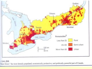
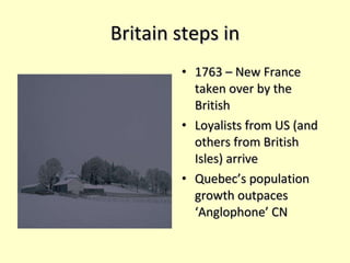
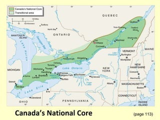
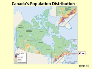
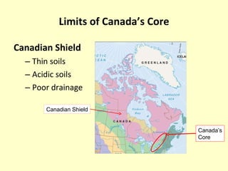
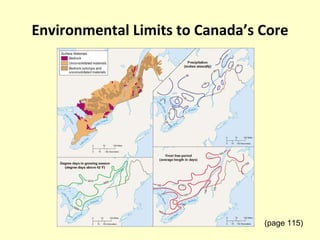
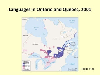
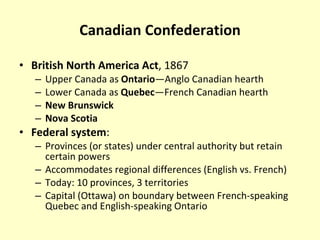
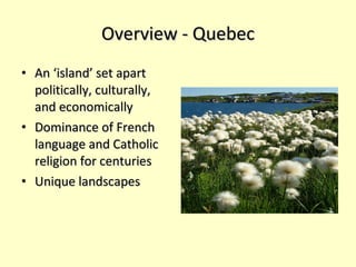
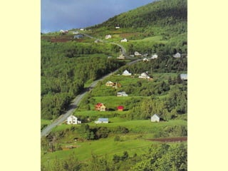
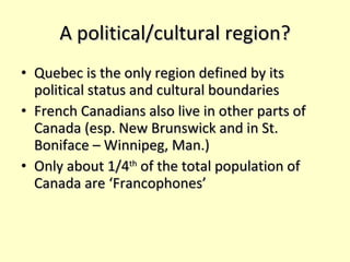
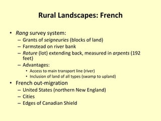
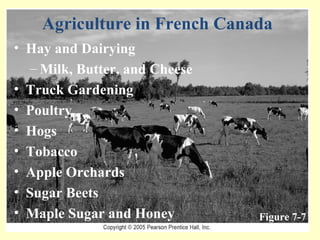
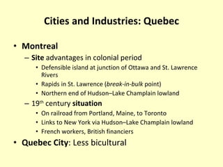
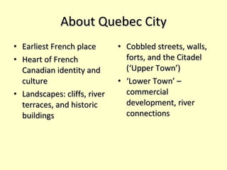
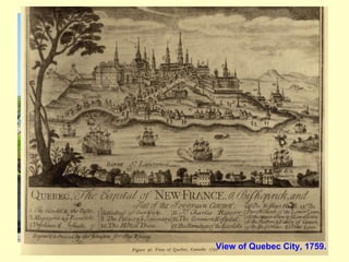
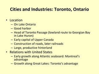
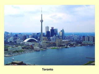
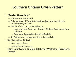
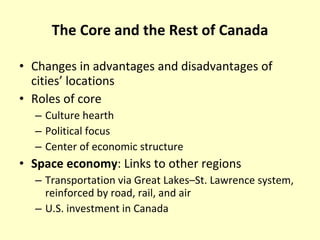
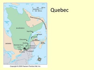
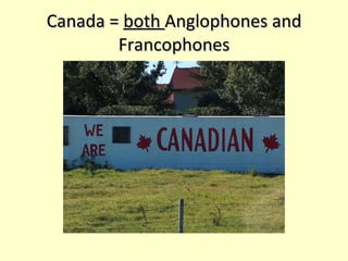
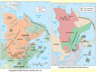
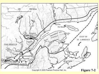
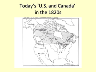
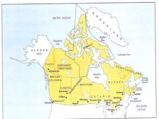
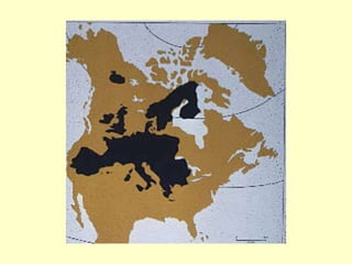
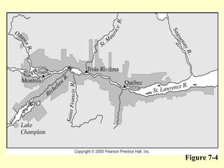
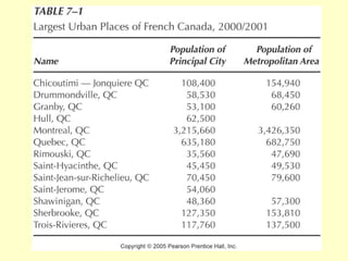
CANADA’S CORE REGION (Chapter 6)
 
Canada’s Population Distribution (page 52) Core
Physical Geography Vegetation Mixed Broadleaf Deciduous  and Needleleaf Evergreen  Maple Significant Soils Overwhelmingly Spodosols Biogeography Historic haunt of the beaver
Introduction Relatively  small size  of Canada’s core, and lack of expansion Marked  cultural division Location as part of North America’s larger core Location far from center of the country Importance of St. Lawrence River Lower Canada (Quebec) Upper Canada (Ontario) Production of  staple products  for export to Europe
Aboriginal and European settlement patterns Dictated by fish, furs, and trade networks (Hurons, Iroquois, and later the French) 1608: French settle in Quebec City on the St. Lawrence (Champlain) – and found their ‘New France’ End of 1600s: French farms and small towns up and down the St. Lawrence
Britain steps in 1763 – New France taken over by the British Loyalists from US (and others from British Isles) arrive Quebec’s population growth outpaces ‘Anglophone’ CN
 
Canada’s National Core (page 113)
Canada’s Population Distribution (page 52) Core
Limits of Canada’s Core Canadian Shield Thin soils Acidic soils Poor drainage Canadian Shield Canada’s Core
Limits to Canada’s Core Climate Length of  growing season Moderating effect of Great Lakes in core Low temperatures,  degree days  (cumulative number of degrees over 42 °  F/5.5° C) Strong trade ties to Europe
Environmental Limits to Canada’s Core (page 115)
Cultural Divisions Core’s constituent provinces (southern parts) Quebec Ontario Similarities between the provinces Located on  access routes  from Europe to Canadian interior Urban commercial centers Rural-to-urban migration Restrictive environmental base Ties to the United States Trade Subsidiary ownership
Cultural Dualism: French Early farmer settlers in  St. Lawrence valley Quebec  and  Montreal  as trading centers Trappers  and  traders  in Ohio–Mississippi–Great Lakes  Strong  cultural base  at time of British conquest (1763) Status today: Language laws in Quebec Federal  bilingualism  (both French and English as official languages) Threats of Quebec to secede
Cultural Dualism: British 1780s: Immigration of British  Loyalists  after American Revolution: Maritime Provinces Upper Canada (Ontario) Additional British, American settlers Ontario: Anglo Canadian culture hearth
Today’s Quebec economies Primary production in some areas (farming, fishing, mining, logging) still important – But urban-industrial development dominates (largest cities = Montreal and Quebec City) Quebec -- Ile d'Orleans dairy farm
Languages in Ontario and Quebec, 2001 (page 118)
Canadian Confederation British North America Act , 1867 Upper Canada as  Ontario —Anglo Canadian hearth Lower Canada as  Quebec —French Canadian hearth New Brunswick Nova Scotia Federal system : Provinces (or states) under central authority but retain certain powers Accommodates regional differences (English vs. French) Today: 10 provinces, 3 territories Capital (Ottawa) on boundary between French-speaking Quebec and English-speaking Ontario
Ottawa
Overview - Quebec An ‘island’ set apart politically, culturally, and economically Dominance of French language and Catholic religion for centuries Unique landscapes
 
A political/cultural region? Quebec is the only region defined by its political status and cultural boundaries French Canadians also live in other parts of Canada (esp. New Brunswick and in St. Boniface – Winnipeg, Man.) Only about 1/4 th  of the total population of Canada are ‘Francophones’
Figure 7-3 L’hiver (Winter)
Rural Landscapes: French Rang  survey system: Grants of  seigneuries  (blocks of land) Farmstead on river bank Roture  (lot) extending back, measured in  arpents  (192 feet) Advantages: Access to main transport line (river) Inclusion of land of all types (swamp to upland) French out-migration United States (northern New England) Cities Edges of Canadian Shield
Figure 7-7 Agriculture in French Canada Hay and Dairying Milk, Butter, and Cheese Truck Gardening Poultry  Hogs Tobacco Apple Orchards Sugar Beets  Maple Sugar and Honey
Forest Industries Key Locations Eastern Townships Gaspe Peninsula Appalachian Uplands Northern New Brunswick Manufacturing Activities Sawmill Pulp Mill Wood-processing Plants Figure 7-8
The French  rang  system is still visible in the rural landscape in Quebec. (page 121)
Figure 7-6
Urban French Canada: The Montreal-Quebec City Axis Quebec City Political Center and Tourism Trois Rivieres Pulp and Paper plus Other Industries Montreal Now #2 for All of Canada Eastern Townships Variety of Industries
Rural Landscapes: British Square or rectangular survey system Individual homesteads Land use: Wheat  (early 1800s) Mixed farming  (raising grain to feed livestock) Dairying Specialty crops Tobacco (middle Lake Erie shore) Fruit (Niagara Peninsula)
Cities and Industries: Quebec Montreal Site  advantages in colonial period Defensible island at junction of Ottawa and St. Lawrence Rivers Rapids in St. Lawrence ( break-in-bulk  point) Northern end of Hudson–Lake Champlain lowland 19 th  century  situation On railroad from Portland, Maine, to Toronto Links to New York via Hudson–Lake Champlain lowland French workers, British financiers Quebec City : Less bicultural
Montreal One of Canada’s largest and most cosmopolitan cities Began on an island in the river Today’s urban landscapes? Problems: businesses moving out, imposing French language on non-Francophone enterprises, etc. Solutions? Underground city, huge port
 
Montreal
 
About Quebec City Earliest French place Heart of French Canadian identity and culture Landscapes: cliffs, river terraces, and historic buildings Cobbled streets, walls, forts, and the Citadel (‘Upper Town’) ‘ Lower Town’ – commercial development, river connections
Quebec City, original wall around the city View of Quebec City, 1759.
Cities and Industries: Toronto, Ontario Location On Lake Ontario Good harbor Head of Toronto Passage (lowland route to Georgian Bay in Lake Huron) Early capital of Upper Canada Construction of roads, later railroads Large, productive hinterland Relations with United States Early growth along Atlantic seaboard: Montreal’s advantage Growth along Great Lakes: Toronto’s advantage
Toronto
Southern Ontario Urban Pattern “ Golden Horseshoe ” Toronto and hinterland Oshawa (east of Toronto)–Hamilton (western end of Lake Ontario)–Niagara Falls Hamilton’s iron and steel industry Iron from Lake Superior, through Welland Canal, now from Labrador Coal from Appalachia, by rail to Buffalo St. Catharines: Hydropower from Niagara Falls Southwestern Ontario Near United States Local mineral resources Cities in between: Guelph, Kitchener-Waterloo, Brantford, London
The Core and the Rest of Canada Changes in advantages and disadvantages of cities’ locations Roles of core Culture hearth Political focus Center of economic structure Space economy : Links to other regions Transportation via Great Lakes–St. Lawrence system, reinforced by road, rail, and air U.S. investment in Canada
Quebec
Canada =  both  Anglophones and Francophones
 
Figure 7-2
Today’s ‘U.S. and Canada’  in the 1820s
 
 
Figure 7-4
 

Ch06ed

  • 1.
  • 2.
  • 3.
  • 4.
    Physical Geography VegetationMixed Broadleaf Deciduous and Needleleaf Evergreen Maple Significant Soils Overwhelmingly Spodosols Biogeography Historic haunt of the beaver
  • 5.
    Introduction Relatively small size of Canada’s core, and lack of expansion Marked cultural division Location as part of North America’s larger core Location far from center of the country Importance of St. Lawrence River Lower Canada (Quebec) Upper Canada (Ontario) Production of staple products for export to Europe
  • 6.
    Aboriginal and Europeansettlement patterns Dictated by fish, furs, and trade networks (Hurons, Iroquois, and later the French) 1608: French settle in Quebec City on the St. Lawrence (Champlain) – and found their ‘New France’ End of 1600s: French farms and small towns up and down the St. Lawrence
  • 7.
    Britain steps in1763 – New France taken over by the British Loyalists from US (and others from British Isles) arrive Quebec’s population growth outpaces ‘Anglophone’ CN
  • 8.
  • 9.
  • 10.
  • 11.
    Limits of Canada’sCore Canadian Shield Thin soils Acidic soils Poor drainage Canadian Shield Canada’s Core
  • 12.
    Limits to Canada’sCore Climate Length of growing season Moderating effect of Great Lakes in core Low temperatures, degree days (cumulative number of degrees over 42 ° F/5.5° C) Strong trade ties to Europe
  • 13.
    Environmental Limits toCanada’s Core (page 115)
  • 14.
    Cultural Divisions Core’sconstituent provinces (southern parts) Quebec Ontario Similarities between the provinces Located on access routes from Europe to Canadian interior Urban commercial centers Rural-to-urban migration Restrictive environmental base Ties to the United States Trade Subsidiary ownership
  • 15.
    Cultural Dualism: FrenchEarly farmer settlers in St. Lawrence valley Quebec and Montreal as trading centers Trappers and traders in Ohio–Mississippi–Great Lakes Strong cultural base at time of British conquest (1763) Status today: Language laws in Quebec Federal bilingualism (both French and English as official languages) Threats of Quebec to secede
  • 16.
    Cultural Dualism: British1780s: Immigration of British Loyalists after American Revolution: Maritime Provinces Upper Canada (Ontario) Additional British, American settlers Ontario: Anglo Canadian culture hearth
  • 17.
    Today’s Quebec economiesPrimary production in some areas (farming, fishing, mining, logging) still important – But urban-industrial development dominates (largest cities = Montreal and Quebec City) Quebec -- Ile d'Orleans dairy farm
  • 18.
    Languages in Ontarioand Quebec, 2001 (page 118)
  • 19.
    Canadian Confederation BritishNorth America Act , 1867 Upper Canada as Ontario —Anglo Canadian hearth Lower Canada as Quebec —French Canadian hearth New Brunswick Nova Scotia Federal system : Provinces (or states) under central authority but retain certain powers Accommodates regional differences (English vs. French) Today: 10 provinces, 3 territories Capital (Ottawa) on boundary between French-speaking Quebec and English-speaking Ontario
  • 20.
  • 21.
    Overview - QuebecAn ‘island’ set apart politically, culturally, and economically Dominance of French language and Catholic religion for centuries Unique landscapes
  • 22.
  • 23.
    A political/cultural region?Quebec is the only region defined by its political status and cultural boundaries French Canadians also live in other parts of Canada (esp. New Brunswick and in St. Boniface – Winnipeg, Man.) Only about 1/4 th of the total population of Canada are ‘Francophones’
  • 24.
  • 25.
    Rural Landscapes: FrenchRang survey system: Grants of seigneuries (blocks of land) Farmstead on river bank Roture (lot) extending back, measured in arpents (192 feet) Advantages: Access to main transport line (river) Inclusion of land of all types (swamp to upland) French out-migration United States (northern New England) Cities Edges of Canadian Shield
  • 26.
    Figure 7-7 Agriculturein French Canada Hay and Dairying Milk, Butter, and Cheese Truck Gardening Poultry Hogs Tobacco Apple Orchards Sugar Beets Maple Sugar and Honey
  • 27.
    Forest Industries KeyLocations Eastern Townships Gaspe Peninsula Appalachian Uplands Northern New Brunswick Manufacturing Activities Sawmill Pulp Mill Wood-processing Plants Figure 7-8
  • 28.
    The French rang system is still visible in the rural landscape in Quebec. (page 121)
  • 29.
  • 30.
    Urban French Canada:The Montreal-Quebec City Axis Quebec City Political Center and Tourism Trois Rivieres Pulp and Paper plus Other Industries Montreal Now #2 for All of Canada Eastern Townships Variety of Industries
  • 31.
    Rural Landscapes: BritishSquare or rectangular survey system Individual homesteads Land use: Wheat (early 1800s) Mixed farming (raising grain to feed livestock) Dairying Specialty crops Tobacco (middle Lake Erie shore) Fruit (Niagara Peninsula)
  • 32.
    Cities and Industries:Quebec Montreal Site advantages in colonial period Defensible island at junction of Ottawa and St. Lawrence Rivers Rapids in St. Lawrence ( break-in-bulk point) Northern end of Hudson–Lake Champlain lowland 19 th century situation On railroad from Portland, Maine, to Toronto Links to New York via Hudson–Lake Champlain lowland French workers, British financiers Quebec City : Less bicultural
  • 33.
    Montreal One ofCanada’s largest and most cosmopolitan cities Began on an island in the river Today’s urban landscapes? Problems: businesses moving out, imposing French language on non-Francophone enterprises, etc. Solutions? Underground city, huge port
  • 34.
  • 35.
  • 36.
  • 37.
    About Quebec CityEarliest French place Heart of French Canadian identity and culture Landscapes: cliffs, river terraces, and historic buildings Cobbled streets, walls, forts, and the Citadel (‘Upper Town’) ‘ Lower Town’ – commercial development, river connections
  • 38.
    Quebec City, originalwall around the city View of Quebec City, 1759.
  • 39.
    Cities and Industries:Toronto, Ontario Location On Lake Ontario Good harbor Head of Toronto Passage (lowland route to Georgian Bay in Lake Huron) Early capital of Upper Canada Construction of roads, later railroads Large, productive hinterland Relations with United States Early growth along Atlantic seaboard: Montreal’s advantage Growth along Great Lakes: Toronto’s advantage
  • 40.
  • 41.
    Southern Ontario UrbanPattern “ Golden Horseshoe ” Toronto and hinterland Oshawa (east of Toronto)–Hamilton (western end of Lake Ontario)–Niagara Falls Hamilton’s iron and steel industry Iron from Lake Superior, through Welland Canal, now from Labrador Coal from Appalachia, by rail to Buffalo St. Catharines: Hydropower from Niagara Falls Southwestern Ontario Near United States Local mineral resources Cities in between: Guelph, Kitchener-Waterloo, Brantford, London
  • 42.
    The Core andthe Rest of Canada Changes in advantages and disadvantages of cities’ locations Roles of core Culture hearth Political focus Center of economic structure Space economy : Links to other regions Transportation via Great Lakes–St. Lawrence system, reinforced by road, rail, and air U.S. investment in Canada
  • 43.
  • 44.
    Canada = both Anglophones and Francophones
  • 45.
  • 46.
  • 47.
    Today’s ‘U.S. andCanada’ in the 1820s
  • 48.
  • 49.
  • 50.
  • 51.