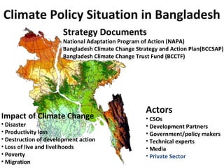
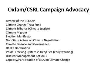
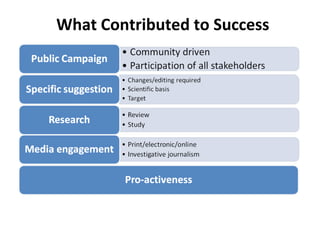
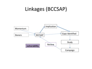
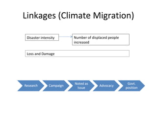
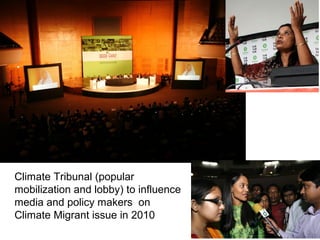
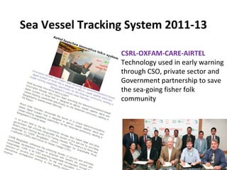
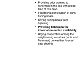
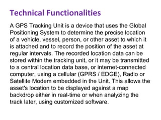
Linking Policy and Practice in Climate
Change Actions in Bangladesh
Learning from Oxfam and partners experiences
Monisha Biswas
Policy Advocacy Manager, Oxfam in Bangladesh
Climate Policy Situation in Bangladesh
Impact of Climate Change
• Disaster
• Productivity loss
• Destruction of development action
• Loss of live and livelihoods
• Poverty
• Migration
Strategy Documents
National Adaptation Program of Action (NAPA)
Bangladesh Climate Change Strategy and Action Plan(BCCSAP)
Bangladesh Climate Change Trust Fund (BCCTF)
Actors
• CSOs
• Development Partners
• Government/policy makers
• Technical experts
• Media
• Private Sector
Oxfam/CSRL Campaign Advocacy
Review of the BCCSAP
Climate Change Trust Fund
Climate Tribunal (Climate Justice)
Climate Migrant
Election Manifesto
Non-State Actors on Climate Negotiation
Climate Finance and Governance
Dhaka Declaration
Vessel Tracking System in Deep Sea (early warning)
Disaster Management Act 2012
Capacity/Participation of NSA on Climate Change
What Contributed to Success
Linkages (BCCSAP)
vulnerability
BCCSAP
Momentum
Donors
Gaps Identified
Study
Campaign
Review
Implication
Linkages (Climate Migration)
Disaster intensity Number of displaced people
increased
Loss and Damage
Climate Tribunal (popular
mobilization and lobby) to influence
media and policy makers on
Climate Migrant issue in 2010
Recommendations from Climate Tribunal
• The Chair of the Climate Tribunal made 15 observations.
• The Tribunal recommended the insertion of a special
constitutional provision on climate change.
• It also recommended to adopt immediately a comprehensive legal
framework on climate change.
• Consequently, in 2011, the amended constitution included a
provision on climate change and environment.
• The Disaster Management Act 2012, defined climate change and
made the provision of rehabilitation of climate affected people.
CSRL-OXFAM-CARE-AIRTEL
Technology used in early warning
through CSO, private sector and
Government partnership to save
the sea-going fisher folk
community
Sea Vessel Tracking System 2011-13
• Providing prior warning to
fishermen in the sea with a lead
time of two days.
• Facilitating identification of sunk
fishing boats.
• Saving fishing boats from
hijacking.
• Providing fishermen the
information on fish availability.
• Urging cooperation among the
neighbouring countries (India and
Myanmar) on weather forecast
data sharing.
A GPS Tracking Unit is a device that uses the Global
Positioning System to determine the precise location
of a vehicle, vessel, person, or other asset to which it
is attached and to record the position of the asset at
regular intervals. The recorded location data can be
stored within the tracking unit, or it may be transmitted
to a central location data base, or internet-connected
computer, using a cellular (GPRS / EDGE), Radio or
Satellite Modem embedded in the Unit. This allows the
asset's location to be displayed against a map
backdrop either in real-time or when analyzing the
track later, using customized software.
Technical Functionalities
THE PROJECT: SCOPE
May June July OctAugust Sept Nov
Warning requires
Coastline 710
KM
Sea extending
to 370 KM
Fishing mostly
within 80 KM
The network
can cover 113
KM
In the coastal Bangladesh fisheries based
livelihoods range between 140,000 and 160,000
THANK YOU

Linking Policy and Practice in Climate Change Actions in Bangladesh

  • 1.
    Linking Policy andPractice in Climate Change Actions in Bangladesh Learning from Oxfam and partners experiences Monisha Biswas Policy Advocacy Manager, Oxfam in Bangladesh
  • 2.
    Climate Policy Situationin Bangladesh Impact of Climate Change • Disaster • Productivity loss • Destruction of development action • Loss of live and livelihoods • Poverty • Migration Strategy Documents National Adaptation Program of Action (NAPA) Bangladesh Climate Change Strategy and Action Plan(BCCSAP) Bangladesh Climate Change Trust Fund (BCCTF) Actors • CSOs • Development Partners • Government/policy makers • Technical experts • Media • Private Sector
  • 3.
    Oxfam/CSRL Campaign Advocacy Reviewof the BCCSAP Climate Change Trust Fund Climate Tribunal (Climate Justice) Climate Migrant Election Manifesto Non-State Actors on Climate Negotiation Climate Finance and Governance Dhaka Declaration Vessel Tracking System in Deep Sea (early warning) Disaster Management Act 2012 Capacity/Participation of NSA on Climate Change
  • 4.
  • 5.
  • 6.
    Linkages (Climate Migration) Disasterintensity Number of displaced people increased Loss and Damage
  • 7.
    Climate Tribunal (popular mobilizationand lobby) to influence media and policy makers on Climate Migrant issue in 2010
  • 8.
    Recommendations from ClimateTribunal • The Chair of the Climate Tribunal made 15 observations. • The Tribunal recommended the insertion of a special constitutional provision on climate change. • It also recommended to adopt immediately a comprehensive legal framework on climate change. • Consequently, in 2011, the amended constitution included a provision on climate change and environment. • The Disaster Management Act 2012, defined climate change and made the provision of rehabilitation of climate affected people.
  • 9.
    CSRL-OXFAM-CARE-AIRTEL Technology used inearly warning through CSO, private sector and Government partnership to save the sea-going fisher folk community Sea Vessel Tracking System 2011-13
  • 10.
    • Providing priorwarning to fishermen in the sea with a lead time of two days. • Facilitating identification of sunk fishing boats. • Saving fishing boats from hijacking. • Providing fishermen the information on fish availability. • Urging cooperation among the neighbouring countries (India and Myanmar) on weather forecast data sharing.
  • 11.
    A GPS TrackingUnit is a device that uses the Global Positioning System to determine the precise location of a vehicle, vessel, person, or other asset to which it is attached and to record the position of the asset at regular intervals. The recorded location data can be stored within the tracking unit, or it may be transmitted to a central location data base, or internet-connected computer, using a cellular (GPRS / EDGE), Radio or Satellite Modem embedded in the Unit. This allows the asset's location to be displayed against a map backdrop either in real-time or when analyzing the track later, using customized software. Technical Functionalities
  • 12.
    THE PROJECT: SCOPE MayJune July OctAugust Sept Nov Warning requires Coastline 710 KM Sea extending to 370 KM Fishing mostly within 80 KM The network can cover 113 KM In the coastal Bangladesh fisheries based livelihoods range between 140,000 and 160,000 THANK YOU