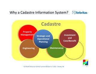
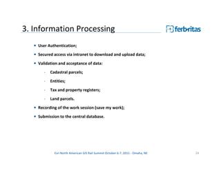
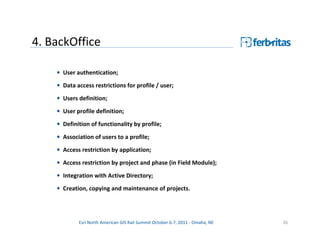
Cadastre Information System
           (FBSIC)
                            Mata, Luís
                           Gil, Fernando


                       Ferbritas, S.A.
                      Lisbon, Portugal


    Esri North American GIS Rail Summit October 6-7, 2011 - Omaha, NE
Agenda


1. FERBRITAS, S.A.

2. The FBSIC Project

3. Presentation of the SIC Web Application

4. Conclusions


         Esri North American GIS Rail Summit October 6-7, 2011 - Omaha, NE   2
Agenda

1. FERBRITAS, S.A.

2. The FBSIC Project

3. Presentation of the SIC Web Application

4. Conclusions


         Esri North American GIS Rail Summit October 6-7, 2011 - Omaha, NE   3
Who are we?


Main Shareholder:

     REFER E.P.E.
     Portuguese Railway Infrastructure Manager

     Ferbritas S.A.
     The engineering company of REFER E.P.E.


         Esri North American GIS Rail Summit October 6-7, 2011 - Omaha, NE   4
Railway specific approach

     Transportation                                                                            Construction
                          Research and             Detailed           Land Acquisition         Management
      Planning and
                          Development               Design                                    and Supervision
       Operation


                                                                     Transportation               Infrastructure
                                                                      Planning and                 Studies and
End to end railway infrastructure planning                             Operation                 Detailed Design

requires:
                                                                                    Construction
                                                                     Quality        Management
•Specific methodologies and multidisciplinary                       Control        and Supervision
                                                                                                       Project
and rigorous approaches;                                               of                            Management
                                                                    Materials
•Integrated management.
                                                                     GIS, Cartography             Cadastre
                                                                     Topography                Land Acquisition


               Esri North American GIS Rail Summit October 6-7, 2011 - Omaha, NE                                   5
Information, activities, …

    Integration                                            No Integration

                                         vs


       Efficiency                                             Waste of resources
     Effectiveness                                        Absence of knowledge
        Results                                             Missed opportunities

         Esri North American GIS Rail Summit October 6-7, 2011 - Omaha, NE         6
Rail information


                                                                                In Operation
     Planning          Feasibility           Detailed            Construction
                                             Design

                                                                                Maintenance


                                                                                   Several
           One decade of information                                             decades of
                                                                                information


           Esri North American GIS Rail Summit October 6-7, 2011 - Omaha, NE                   7
Rail and GIS – our awareness
1. The modernization and maintenance of a railway network is an extensive process          -
   of decades - that generates a colossal volume of related and diverse information
   during it’s long life cycle;

2. All this valuable and different information is produced, processed (or not) and filed
   (or not) during many years by generations of people across multiple organizations
   (and reorganizations);

3. Information for itself it’s not equivalent to knowledge;

4. Both are indispensable and represent significant value, to infrastructure managers
   and operators.
Conclusion: Using a Corporate Spatial Data Infrastructure (SDI) to
               integrate information and build up the appropriated
               applications to railway business is one of our key strategic
               options.
               Esri North American GIS Rail Summit October 6-7, 2011 - Omaha, NE      8
Agenda


1. FERBRITAS, S.A.

2. The FBSIC Project

3. Presentation of the SIC Web Application

4. Conclusions


         Esri North American GIS Rail Summit October 6-7, 2011 - Omaha, NE   9
Why a Cadastre Information System?


                                    Cadastre
       Property
      Management                                                        Investment
                            Strategic and
                             Operational                                    and
                              Planning                                 Cost/Benefit


       Engineering                                Maintenance


        Esri North American GIS Rail Summit October 6-7, 2011 - Omaha, NE             10
Why a Cadastre Information System?
 Business opportunities and responsibilities


                              Decision making
     Accurate                               Business                            Effectiveness
   Information                              Process
                     Knowledge                                   Efficiency


            Esri North American GIS Rail Summit October 6-7, 2011 - Omaha, NE                   11
Why a Cadastre Information System?
   Feasibility Studies


   Preliminary Studies
                                                                                               Physical
                                                                                            Demarcation of
   Environmental                                                                              Property
   Studies                                        Construction
                                                 management and                                  As-Built
   Environmental                                   supervision                                  Drawings
   Statement


   Detailed Design


                                                                                              Availability of
                                       Process of acquisition (negotiation, legal and tax
                                                                                                 site for
                                                          issues, etc.)
                                                                                              construction
   Environmental
   Licensing Process


                   Esri North American GIS Rail Summit October 6-7, 2011 - Omaha, NE                            12
Why a Cadastre Information System?
Conclusions:
-Accurate cadastre information is a significant input to other key activities of railway companies
(engineering, maintenance, operation, lease, …);

-A cadastre recovery process has an exponential ROI to the global business;

-Property means value! … if we know:                                                  Integration
• what we have;
• where it is;
• which rights and responsibilities;
• what is essential and what is dispensable;
• what is the potential profitability;
• what are the opportunities and what we want to do with it;
                                                                                       Results
• …

-        It’s not only a matter of gathering accurate information. The purpose is to deliver
knowledge to promote business;

-          It‘s worth it: it’s added value!
                  Esri North American GIS Rail Summit October 6-7, 2011 - Omaha, NE                  13
FBSIC - General Objectives
 • View, query and edit of geographic and alphanumeric information of land parcels;

 • Quality control of cadastre and real estate;

 • Traceability of the processes;

 • Map printing and creation of formal documents;

 • Final approval by the customer (internal or external);

 • Scalable solution;

 • Supported by standards for information technology and communication, and
   interoperability;

 • Long-term sustainability to the project.

              Esri North American GIS Rail Summit October 6-7, 2011 - Omaha, NE   14
FBSIC - System Components

 • Database …………………… (Alphanumeric / GIS): MS SQL Server 2008

 • File Server …………………. Pictures, CAD files, Pdf...

 • GIS Services .................. ArcGIS Server and ArcGIS Image Server

 • Desktop GIS ………………. ArcGIS / ArcInfo and its extensions

 • Web Application ………. Taylor made solution: user interfaces, alpha/geo
                                 editing, extended image support, automatic
                                 document generation, linked with document
                                 management


               Esri North American GIS Rail Summit October 6-7, 2011 - Omaha, NE   15
One solution, seven modules
 1. Field ……………………………….… collection of information at the field

 2. Data Migration ………………… geographic and alphanumeric data

 3. Information Processing …... validation for integration of collected data

 4. BackOffice ………………….……. supporting system administration

 5. Central …………………………….. view/edit geo/alpha information, quality
                                        control, generation and printing of documents, …

 6. Approval ……………………….…. enabling interaction and approval by the client

 7. Domain Management …….. enabling an enterprise management of private
                                        and public domain property


             Esri North American GIS Rail Summit October 6-7, 2011 - Omaha, NE             16
FBSIC - Conceptual Architecture


        Esri North American GIS Rail Summit October 6-7, 2011 - Omaha, NE   17
One solution, seven modules

 1. Field ……………………………….… collection of information at the field

 2. Data Migration ………………… geographic and alphanumeric data

 3. Information Processing …... validation for integration of collected data

 4. BackOffice ………………….……. supporting system administration

 5. Central …………………………….. view/edit geo/alpha information, quality
                                        control, generation and printing of documents, …

 6. Approval ……………………….…. enabling interaction and approval by the client

 7. Domain Management …….. enabling an enterprise management of private
                                        and public domain property


             Esri North American GIS Rail Summit October 6-7, 2011 - Omaha, NE             18
1.Field (operation cycle)


         Esri North American GIS Rail Summit October 6-7, 2011 - Omaha, NE   19
1.Field (cont.)

  • User Authentication;
  • Access restrictions on a user base;
  • Secured access via intranet to download and upload data;

  • Data insert, edit and query:
       - cadastral parcels, land parcels, entities, tax and property registers;

  • Address validation according to postal format;
  • Data validation (format and completeness) for cadastral parcels;
  • Warnings and Errors Log for performance quality metrics;

  • Data validation before submission to the central database;
  • Autonomy of operation in offline mode.


               Esri North American GIS Rail Summit October 6-7, 2011 - Omaha, NE   20
1.Field (cont.)


         Esri North American GIS Rail Summit October 6-7, 2011 - Omaha, NE   21
2.Data Migration
  Composed of four toolbars (ArcGIS/ArcEditor):
       • Import of CAD data;
       • Creating new layers;

       • Validation of the topology;
       • Validation of attributes;
       • Table mapping layers;
       • Automatic creation of polygons from lines;

       • Association of annotations to features;
       • Controlled upload to the central database;
       • User and date / time log for each record.


             Esri North American GIS Rail Summit October 6-7, 2011 - Omaha, NE   22
2.Data Migration (cont.)


        Esri North American GIS Rail Summit October 6-7, 2011 - Omaha, NE   23
3. Information Processing
   • User Authentication;
   • Secured access via intranet to download and upload data;
   • Validation and acceptance of data:
        -   Cadastral parcels;
        -   Entities;

        -   Tax and property registers;
        -   Land parcels.
   • Recording of the work session (save my work);

   • Submission to the central database.


              Esri North American GIS Rail Summit October 6-7, 2011 - Omaha, NE   24
3. Information Processing (cont.)


         Esri North American GIS Rail Summit October 6-7, 2011 - Omaha, NE   25
4. BackOffice

    • User authentication;
    • Data access restrictions for profile / user;

    • Users definition;

    • User profile definition;
    • Definition of functionality by profile;

    • Association of users to a profile;
    • Access restriction by application;
    • Access restriction by project and phase (in Field Module);

    • Integration with Active Directory;
    • Creation, copying and maintenance of projects.


            Esri North American GIS Rail Summit October 6-7, 2011 - Omaha, NE   26
4. BackOffice (cont.)


         Esri North American GIS Rail Summit October 6-7, 2011 - Omaha, NE   27
5. Central

   • User Authentication;
   • Data access restrictions for profile / user;

   • Data insert, edit and query of:
        -   cadastral parcels, land parcels, entities, tax and property registers;
   • Address validation according Postal format;
   • Integration of geographic and alphanumeric information, imagery and
     documents;
   • Workflow control of the project phases;
   • Query and generation of snapshots.


              Esri North American GIS Rail Summit October 6-7, 2011 - Omaha, NE      28
5. Central (cont.)
   • Documents generation:

       -   Temporary Cadastral Report (.pdf)
       -   Cadastral Parcel Report (.pdf)

       -   Land Parcel Report (.xls)
       -   Easy Print (.pdf)
       -   Cadastral Parcels Plant (.pdf)

       -   Land Parcels Plant (.pdf)
       -   Land Parcels Extract (.pdf)
   • Integration with the Document Management System:

       -   Property Registry Documents;
       -   Finance Documents.


             Esri North American GIS Rail Summit October 6-7, 2011 - Omaha, NE   29
5. Central (cont.)


         Esri North American GIS Rail Summit October 6-7, 2011 - Omaha, NE   30
6. Approval
  • User Authentication;

  • Data access restrictions for profile, user, phase and project;
  • Project navigation;
  • Cadastral and Land parcels information analysis (geographic and alphanumeric);
  • Insertion of annotations and corrections to the data in analysis;
  • Visualization of information to support analysis (criteria);

  • Integration with vector information of the Engineering Project;
  • Availability of measurement tools;
  • Availability of search tools (query builder) ;

  • History log of analysis and validation acts (what, who and when);
  • Search by analysis state.


               Esri North American GIS Rail Summit October 6-7, 2011 - Omaha, NE     31
6. Approval (life cycle)


         Esri North American GIS Rail Summit October 6-7, 2011 - Omaha, NE   32
6. Approval (cont.)


         Esri North American GIS Rail Summit October 6-7, 2011 - Omaha, NE   33
7. Domain
• Access to data with user restrictions;
• Queries for Projects, Land parcels, Railroad Lines, Railroad Segments and KPs;
• Integration between of geographic and alphanumeric cadastre information;

• Visualization of context geographic information (orthophotos, military and street
  maps);
• Control of the Land parcels process state;

• Automatic update of the Public Domain after acquisition of the Land parcel;
• View the history of parcel states;
• Generation of official documentation (Cadastral Parcel and Land Parcel Report,
  Cadastral Parcels and Land Parcels Plants, Land Parcels Extracts);

• Integration with the Document Management System;
• Export of alphanumeric data, graphics and documents.


               Esri North American GIS Rail Summit October 6-7, 2011 - Omaha, NE      34
7.Domain (cont.)


        Esri North American GIS Rail Summit October 6-7, 2011 - Omaha, NE   35
Agenda


1. FERBRITAS, S.A.

2. The FBSIC Project

3. Presentation of the SIC Web Application

4. Conclusions


         Esri North American GIS Rail Summit October 6-7, 2011 - Omaha, NE   36
FBSIC – Central Module


        Esri North American GIS Rail Summit October 6-7, 2011 - Omaha, NE   37
Agenda


1. FERBRITAS, S.A.

2. The FBSIC Project

3. Presentation of the SIC Web Application

4. Conclusions


         Esri North American GIS Rail Summit October 6-7, 2011 - Omaha, NE   38
FBSIC – Accuracy and Efficiency
Data Integrity:
 • Centralization of information;
 • Validation of data quality (amount and form);
 • Log into a relational database.
Data availability:
 • Speed of access;
 • Secure access to profile, functionality and design;
 • Possibility of integration with other systems.
Usability of the data:
 • Geographical and alphanumeric display;
 • Generation of documentation;
 • Analysis of efficiency indicators of the operational process.


               Esri North American GIS Rail Summit October 6-7, 2011 - Omaha, NE   39
FBSIC – Integration

 The integrating nature of FBSIC allows:

  • to accomplish present needs and scale to meet future services;

  • to collect, maintain, manage and share all information in one common
    platform, and transform it into knowledge;

  • to relate with other platforms;

  • to increase accuracy and productivity of business processes related with
    property management.


              Esri North American GIS Rail Summit October 6-7, 2011 - Omaha, NE   40
Our experience
•   It takes sometime to have a full and accurate data
    base. But if the right priorities are taken, e.g. by                                                  Return
    selecting relevant segments of network, then results                                                                D.B.
    appear earlier and evolves in an exponential trend.
•   Cadastre control (CC) contributes to cost-cutting:
    taxation, liability, maintenance, …
•   CC increases efficiency, effectiveness and                                                            or
    cost/benefit optimization, related to key activities of
    a railway operator or infrastructure manager:
    engineering, maintenance, lease, network                                             Cadastre Control
    upgrading, facilities, …
                                                                             Property        Strategic
                                                                            Management                          Investment
•   CC is a crucial topic for every organization that                                           and
                                                                                                                    and
                                                                                            Operational
                                                                                                               Cost/Benefit
    manages railway infrastructure.                                                          Planning

                                                                              Engineering             Maintenance
•   Business demands it!
•   It’s worth it!
                     Esri North American GIS Rail Summit October 6-7, 2011 - Omaha, NE                                         41
Thank you for your time and interest!

          Obrigado!

Ferbritas, S.A.                                Luis Mata                              Fernando Gil
                                               CEO                                    GIO – Head of GIS
Rua José da Costa Pedreira, 11
1750-130 Lisboa, Portugal                      mata@ferbritas.pt                      fgil@ferbritas.pt
Tel: +351 217 511 700
Fax: +351 210 118 080
Web: www.ferbritas.pt


                  Esri North American GIS Rail Summit October 6-7, 2011 - Omaha, NE                       42

Cadastre Information System - Esri US GIS Rail Summit 2011, Omaha - NE

  • 1.
    Cadastre Information System (FBSIC) Mata, Luís Gil, Fernando Ferbritas, S.A. Lisbon, Portugal Esri North American GIS Rail Summit October 6-7, 2011 - Omaha, NE
  • 2.
    Agenda 1. FERBRITAS, S.A. 2.The FBSIC Project 3. Presentation of the SIC Web Application 4. Conclusions Esri North American GIS Rail Summit October 6-7, 2011 - Omaha, NE 2
  • 3.
    Agenda 1. FERBRITAS, S.A. 2.The FBSIC Project 3. Presentation of the SIC Web Application 4. Conclusions Esri North American GIS Rail Summit October 6-7, 2011 - Omaha, NE 3
  • 4.
    Who are we? MainShareholder: REFER E.P.E. Portuguese Railway Infrastructure Manager Ferbritas S.A. The engineering company of REFER E.P.E. Esri North American GIS Rail Summit October 6-7, 2011 - Omaha, NE 4
  • 5.
    Railway specific approach Transportation Construction Research and Detailed Land Acquisition Management Planning and Development Design and Supervision Operation Transportation Infrastructure Planning and Studies and End to end railway infrastructure planning Operation Detailed Design requires: Construction Quality Management •Specific methodologies and multidisciplinary Control and Supervision Project and rigorous approaches; of Management Materials •Integrated management. GIS, Cartography Cadastre Topography Land Acquisition Esri North American GIS Rail Summit October 6-7, 2011 - Omaha, NE 5
  • 6.
    Information, activities, … Integration No Integration vs Efficiency Waste of resources Effectiveness Absence of knowledge Results Missed opportunities Esri North American GIS Rail Summit October 6-7, 2011 - Omaha, NE 6
  • 7.
    Rail information In Operation Planning Feasibility Detailed Construction Design Maintenance Several One decade of information decades of information Esri North American GIS Rail Summit October 6-7, 2011 - Omaha, NE 7
  • 8.
    Rail and GIS– our awareness 1. The modernization and maintenance of a railway network is an extensive process - of decades - that generates a colossal volume of related and diverse information during it’s long life cycle; 2. All this valuable and different information is produced, processed (or not) and filed (or not) during many years by generations of people across multiple organizations (and reorganizations); 3. Information for itself it’s not equivalent to knowledge; 4. Both are indispensable and represent significant value, to infrastructure managers and operators. Conclusion: Using a Corporate Spatial Data Infrastructure (SDI) to integrate information and build up the appropriated applications to railway business is one of our key strategic options. Esri North American GIS Rail Summit October 6-7, 2011 - Omaha, NE 8
  • 9.
    Agenda 1. FERBRITAS, S.A. 2.The FBSIC Project 3. Presentation of the SIC Web Application 4. Conclusions Esri North American GIS Rail Summit October 6-7, 2011 - Omaha, NE 9
  • 10.
    Why a CadastreInformation System? Cadastre Property Management Investment Strategic and Operational and Planning Cost/Benefit Engineering Maintenance Esri North American GIS Rail Summit October 6-7, 2011 - Omaha, NE 10
  • 11.
    Why a CadastreInformation System? Business opportunities and responsibilities Decision making Accurate Business Effectiveness Information Process Knowledge Efficiency Esri North American GIS Rail Summit October 6-7, 2011 - Omaha, NE 11
  • 12.
    Why a CadastreInformation System? Feasibility Studies Preliminary Studies Physical Demarcation of Environmental Property Studies Construction management and As-Built Environmental supervision Drawings Statement Detailed Design Availability of Process of acquisition (negotiation, legal and tax site for issues, etc.) construction Environmental Licensing Process Esri North American GIS Rail Summit October 6-7, 2011 - Omaha, NE 12
  • 13.
    Why a CadastreInformation System? Conclusions: -Accurate cadastre information is a significant input to other key activities of railway companies (engineering, maintenance, operation, lease, …); -A cadastre recovery process has an exponential ROI to the global business; -Property means value! … if we know: Integration • what we have; • where it is; • which rights and responsibilities; • what is essential and what is dispensable; • what is the potential profitability; • what are the opportunities and what we want to do with it; Results • … - It’s not only a matter of gathering accurate information. The purpose is to deliver knowledge to promote business; - It‘s worth it: it’s added value! Esri North American GIS Rail Summit October 6-7, 2011 - Omaha, NE 13
  • 14.
    FBSIC - GeneralObjectives • View, query and edit of geographic and alphanumeric information of land parcels; • Quality control of cadastre and real estate; • Traceability of the processes; • Map printing and creation of formal documents; • Final approval by the customer (internal or external); • Scalable solution; • Supported by standards for information technology and communication, and interoperability; • Long-term sustainability to the project. Esri North American GIS Rail Summit October 6-7, 2011 - Omaha, NE 14
  • 15.
    FBSIC - SystemComponents • Database …………………… (Alphanumeric / GIS): MS SQL Server 2008 • File Server …………………. Pictures, CAD files, Pdf... • GIS Services .................. ArcGIS Server and ArcGIS Image Server • Desktop GIS ………………. ArcGIS / ArcInfo and its extensions • Web Application ………. Taylor made solution: user interfaces, alpha/geo editing, extended image support, automatic document generation, linked with document management Esri North American GIS Rail Summit October 6-7, 2011 - Omaha, NE 15
  • 16.
    One solution, sevenmodules 1. Field ……………………………….… collection of information at the field 2. Data Migration ………………… geographic and alphanumeric data 3. Information Processing …... validation for integration of collected data 4. BackOffice ………………….……. supporting system administration 5. Central …………………………….. view/edit geo/alpha information, quality control, generation and printing of documents, … 6. Approval ……………………….…. enabling interaction and approval by the client 7. Domain Management …….. enabling an enterprise management of private and public domain property Esri North American GIS Rail Summit October 6-7, 2011 - Omaha, NE 16
  • 17.
    FBSIC - ConceptualArchitecture Esri North American GIS Rail Summit October 6-7, 2011 - Omaha, NE 17
  • 18.
    One solution, sevenmodules 1. Field ……………………………….… collection of information at the field 2. Data Migration ………………… geographic and alphanumeric data 3. Information Processing …... validation for integration of collected data 4. BackOffice ………………….……. supporting system administration 5. Central …………………………….. view/edit geo/alpha information, quality control, generation and printing of documents, … 6. Approval ……………………….…. enabling interaction and approval by the client 7. Domain Management …….. enabling an enterprise management of private and public domain property Esri North American GIS Rail Summit October 6-7, 2011 - Omaha, NE 18
  • 19.
    1.Field (operation cycle) Esri North American GIS Rail Summit October 6-7, 2011 - Omaha, NE 19
  • 20.
    1.Field (cont.) • User Authentication; • Access restrictions on a user base; • Secured access via intranet to download and upload data; • Data insert, edit and query: - cadastral parcels, land parcels, entities, tax and property registers; • Address validation according to postal format; • Data validation (format and completeness) for cadastral parcels; • Warnings and Errors Log for performance quality metrics; • Data validation before submission to the central database; • Autonomy of operation in offline mode. Esri North American GIS Rail Summit October 6-7, 2011 - Omaha, NE 20
  • 21.
    1.Field (cont.) Esri North American GIS Rail Summit October 6-7, 2011 - Omaha, NE 21
  • 22.
    2.Data Migration Composed of four toolbars (ArcGIS/ArcEditor): • Import of CAD data; • Creating new layers; • Validation of the topology; • Validation of attributes; • Table mapping layers; • Automatic creation of polygons from lines; • Association of annotations to features; • Controlled upload to the central database; • User and date / time log for each record. Esri North American GIS Rail Summit October 6-7, 2011 - Omaha, NE 22
  • 23.
    2.Data Migration (cont.) Esri North American GIS Rail Summit October 6-7, 2011 - Omaha, NE 23
  • 24.
    3. Information Processing • User Authentication; • Secured access via intranet to download and upload data; • Validation and acceptance of data: - Cadastral parcels; - Entities; - Tax and property registers; - Land parcels. • Recording of the work session (save my work); • Submission to the central database. Esri North American GIS Rail Summit October 6-7, 2011 - Omaha, NE 24
  • 25.
    3. Information Processing(cont.) Esri North American GIS Rail Summit October 6-7, 2011 - Omaha, NE 25
  • 26.
    4. BackOffice • User authentication; • Data access restrictions for profile / user; • Users definition; • User profile definition; • Definition of functionality by profile; • Association of users to a profile; • Access restriction by application; • Access restriction by project and phase (in Field Module); • Integration with Active Directory; • Creation, copying and maintenance of projects. Esri North American GIS Rail Summit October 6-7, 2011 - Omaha, NE 26
  • 27.
    4. BackOffice (cont.) Esri North American GIS Rail Summit October 6-7, 2011 - Omaha, NE 27
  • 28.
    5. Central • User Authentication; • Data access restrictions for profile / user; • Data insert, edit and query of: - cadastral parcels, land parcels, entities, tax and property registers; • Address validation according Postal format; • Integration of geographic and alphanumeric information, imagery and documents; • Workflow control of the project phases; • Query and generation of snapshots. Esri North American GIS Rail Summit October 6-7, 2011 - Omaha, NE 28
  • 29.
    5. Central (cont.) • Documents generation: - Temporary Cadastral Report (.pdf) - Cadastral Parcel Report (.pdf) - Land Parcel Report (.xls) - Easy Print (.pdf) - Cadastral Parcels Plant (.pdf) - Land Parcels Plant (.pdf) - Land Parcels Extract (.pdf) • Integration with the Document Management System: - Property Registry Documents; - Finance Documents. Esri North American GIS Rail Summit October 6-7, 2011 - Omaha, NE 29
  • 30.
    5. Central (cont.) Esri North American GIS Rail Summit October 6-7, 2011 - Omaha, NE 30
  • 31.
    6. Approval • User Authentication; • Data access restrictions for profile, user, phase and project; • Project navigation; • Cadastral and Land parcels information analysis (geographic and alphanumeric); • Insertion of annotations and corrections to the data in analysis; • Visualization of information to support analysis (criteria); • Integration with vector information of the Engineering Project; • Availability of measurement tools; • Availability of search tools (query builder) ; • History log of analysis and validation acts (what, who and when); • Search by analysis state. Esri North American GIS Rail Summit October 6-7, 2011 - Omaha, NE 31
  • 32.
    6. Approval (lifecycle) Esri North American GIS Rail Summit October 6-7, 2011 - Omaha, NE 32
  • 33.
    6. Approval (cont.) Esri North American GIS Rail Summit October 6-7, 2011 - Omaha, NE 33
  • 34.
    7. Domain • Accessto data with user restrictions; • Queries for Projects, Land parcels, Railroad Lines, Railroad Segments and KPs; • Integration between of geographic and alphanumeric cadastre information; • Visualization of context geographic information (orthophotos, military and street maps); • Control of the Land parcels process state; • Automatic update of the Public Domain after acquisition of the Land parcel; • View the history of parcel states; • Generation of official documentation (Cadastral Parcel and Land Parcel Report, Cadastral Parcels and Land Parcels Plants, Land Parcels Extracts); • Integration with the Document Management System; • Export of alphanumeric data, graphics and documents. Esri North American GIS Rail Summit October 6-7, 2011 - Omaha, NE 34
  • 35.
    7.Domain (cont.) Esri North American GIS Rail Summit October 6-7, 2011 - Omaha, NE 35
  • 36.
    Agenda 1. FERBRITAS, S.A. 2.The FBSIC Project 3. Presentation of the SIC Web Application 4. Conclusions Esri North American GIS Rail Summit October 6-7, 2011 - Omaha, NE 36
  • 37.
    FBSIC – CentralModule Esri North American GIS Rail Summit October 6-7, 2011 - Omaha, NE 37
  • 38.
    Agenda 1. FERBRITAS, S.A. 2.The FBSIC Project 3. Presentation of the SIC Web Application 4. Conclusions Esri North American GIS Rail Summit October 6-7, 2011 - Omaha, NE 38
  • 39.
    FBSIC – Accuracyand Efficiency Data Integrity: • Centralization of information; • Validation of data quality (amount and form); • Log into a relational database. Data availability: • Speed of access; • Secure access to profile, functionality and design; • Possibility of integration with other systems. Usability of the data: • Geographical and alphanumeric display; • Generation of documentation; • Analysis of efficiency indicators of the operational process. Esri North American GIS Rail Summit October 6-7, 2011 - Omaha, NE 39
  • 40.
    FBSIC – Integration The integrating nature of FBSIC allows: • to accomplish present needs and scale to meet future services; • to collect, maintain, manage and share all information in one common platform, and transform it into knowledge; • to relate with other platforms; • to increase accuracy and productivity of business processes related with property management. Esri North American GIS Rail Summit October 6-7, 2011 - Omaha, NE 40
  • 41.
    Our experience • It takes sometime to have a full and accurate data base. But if the right priorities are taken, e.g. by Return selecting relevant segments of network, then results D.B. appear earlier and evolves in an exponential trend. • Cadastre control (CC) contributes to cost-cutting: taxation, liability, maintenance, … • CC increases efficiency, effectiveness and or cost/benefit optimization, related to key activities of a railway operator or infrastructure manager: engineering, maintenance, lease, network Cadastre Control upgrading, facilities, … Property Strategic Management Investment • CC is a crucial topic for every organization that and and Operational Cost/Benefit manages railway infrastructure. Planning Engineering Maintenance • Business demands it! • It’s worth it! Esri North American GIS Rail Summit October 6-7, 2011 - Omaha, NE 41
  • 42.
    Thank you foryour time and interest! Obrigado! Ferbritas, S.A. Luis Mata Fernando Gil CEO GIO – Head of GIS Rua José da Costa Pedreira, 11 1750-130 Lisboa, Portugal mata@ferbritas.pt fgil@ferbritas.pt Tel: +351 217 511 700 Fax: +351 210 118 080 Web: www.ferbritas.pt Esri North American GIS Rail Summit October 6-7, 2011 - Omaha, NE 42