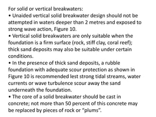
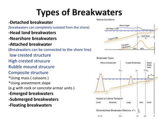
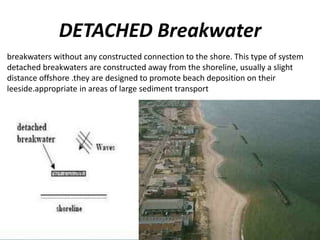
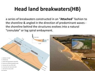
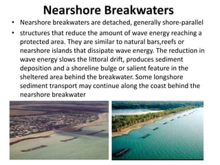
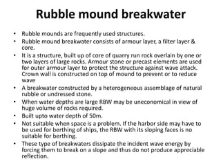
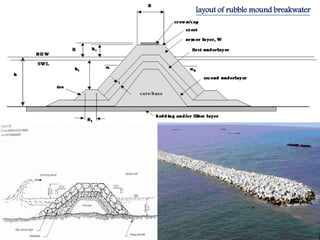
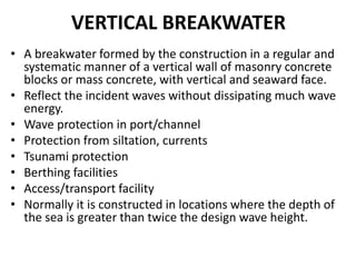
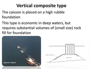
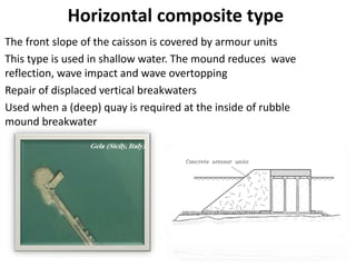
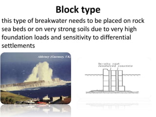
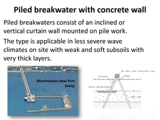
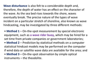
Breakwaters are structures built along coastlines to protect harbors, anchorages, and shore areas from wave damage. They work by reflecting and dissipating wave energy. There are several types of breakwaters including detached, headland, nearshore, attached, rubble mound, vertical, and submerged. Planning a breakwater requires detailed surveys of the site hydrography, sea bed geology, wave climate, material needs, and cross-sectional design. Proper planning ensures breakwaters are engineered to withstand local conditions and provide effective coastal protection.
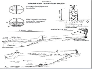
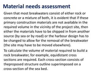
This document discusses different types of breakwaters. Breakwaters are structures built along coasts to protect areas from wave disturbance. There are three main categories: rubble mound breakwaters, vertical-wall breakwaters, and floating breakwaters. Rubble mound breakwaters are constructed from natural rubble or stone and are the most widely used in Indian ports due to their cost-effectiveness. Vertical-wall breakwaters use concrete blocks or mass concrete and reflect waves without dissipating much energy. Floating breakwaters are removable structures constructed from caissons or pontoons that can be sunk or floated as needed.
- Jetties are structures built into the sea to protect harbors and influence water currents. They divert river currents away from banks and control navigation. In seas, jetties extend from shore to deep water to shelter ships.
- Common types of jetties include random stone, stone and concrete, caisson, crib, and asphalt. Caisson and crib jetties are built off-site and floated into position. Stone and concrete jetties combine rubble and concrete materials.
- Breakwaters are coastal structures that protect harbors from waves and drift. Common types include detached, headland, nearshore, attached, emerged, submerged, and floating breakwaters built of rubble mound, vertical
The document discusses different types of breakwaters used to protect coastal areas from wave attack. It describes rubble mound breakwaters, vertical-wall breakwaters, and floating breakwaters. Rubble mound breakwaters are constructed from natural rubble or stone and dissipate wave energy through breaking. Vertical-wall breakwaters use a vertical wall structure and reflect wave energy. Floating breakwaters are removable structures constructed from caissons or pontoons that are anchored but less effective against long waves. The document provides details on the characteristics, uses, advantages, and disadvantages of each type of breakwater.
The document discusses various methods for mitigating coastal erosion, including both hard and soft structural approaches. Hard structural methods discussed include jetties, seawalls, groins, revetments, and breakwaters. Soft structural approaches include beach nourishment and sand dune stabilization. Each method is described and their advantages and disadvantages are provided. In conclusion, coastal erosion affects the environment and communities require long-term strategies informed by science and engineering to control erosion.
This document provides information on different types of breakwaters, including rubble mound, detached, attached, and solid or vertical breakwaters. It discusses parameters for breakwater construction such as geotechnical investigations, wave hindcasting, and cross-sectional design. Rubble mound breakwaters are made of quarried rock and armor stones and are suitable for shallower depths, while caisson breakwaters can be used in deeper waters. Proper design considers factors like foundation material, water depth, and wave height.
This document discusses coastal erosion, its causes, impacts, and various mitigation approaches. It identifies key physical parameters that contribute to coastal erosion like waves, tides, and vegetation. Approaches to mitigate erosion include hard engineering methods like seawalls, breakwaters, and groynes, as well as soft engineering methods like beach nourishment, relocating structures, planting mangroves, and growing coral reefs. Hard structures provide direct protection but can have negative environmental impacts. Soft methods aim to work with natural coastal processes but have challenges with feasibility and cost. Overall management requires consideration of engineering and environmental factors.
The document discusses various hard engineering methods for coastal management including seawalls, breakwaters, and groynes.
Seawalls are sloping or vertical concrete walls built parallel to the coast to absorb wave energy. However, the reflected waves increase erosion below the wall.
Breakwaters are structures built parallel to the coast some distance away to break wave force before reaching land. They reduce erosion but can cause erosion in unprotected areas.
Groynes are perpendicular structures that trap sediment on the side facing longshore drift, building up beaches but potentially causing erosion on the opposite side if not spaced correctly.
All hard structures have benefits but also problems like erosion in unprotected areas and need for regular maintenance. Soft
1. The document discusses different types of coastal structures, their functions, and applications for protecting coastlines and infrastructure from erosion, flooding, and wave damage.
2. It describes soft structures like beachfill and dunes that erode naturally, and hard structures like seawalls, revetments, breakwaters and jetties that are more permanent.
3. The structures protect coastlines and navigation channels, stabilize shorelines and beaches, and enhance recreation; with advantages of hard structures being ability to withstand large forces and function in deep water.
This document defines key terms related to coastal management strategies and engineering approaches. It discusses soft engineering approaches like beach nourishment, beach re-profiling, dune regeneration, and offshore reefs that use natural systems to help with coastal defenses. Hard engineering involves physical structures like groynes, sea walls, gabions, revetments, and rock armour/riprap to reduce erosion and flooding risks. Soft approaches are more natural but hard structures provide stronger defenses. Coastal management requires balancing engineering solutions with environmental impacts.
Breakwaters, jetties, and groins are coastal structures used to protect harbors and shorelines from wave energy. Breakwaters are structures that reflect and dissipate wave energy to shelter harbors. Jetties are narrow structures that project from the shore into water and provide berths for ships. Groins are structures built perpendicular to the shore to trap littoral drift and protect or build beaches. There are different types of each structure based on materials, permeability, and orientation relative to shorelines and water flow.
This document provides an overview of hydraulic structures and classifications of dams. It discusses:
1) Different types of dams classified by function (storage, detention, diversion), design (overflow, non-overflow), structure (gravity, arch, buttress, embankment), and materials (rigid, non-rigid).
2) Characteristics and components of earth dams including homogeneous, zoned, and diaphragm types.
3) Characteristics of rock fill dams and combined earth and rock fill dams.
4) Advantages and disadvantages of gravity dams, arch dams, and buttress dams constructed of concrete.
Earthen dams are constructed using natural materials like clay, sand, gravel and rock. They are designed based on principles of soil mechanics. There are two main types - homogeneous and zoned. Zoned dams have an impervious core and outer shells. Components include the core, shells, rock toe, pitching, berms and drains. Stability requires the seepage line be within the downstream slope with minimum 2m cover. Common causes of failure are hydraulic (overtopping, erosion), seepage (piping through core or foundations) and structural issues like cracking. Proper design and construction can prevent these failures.
Retaining walls are an integral part of any sea facing structure or structures which contain single or multiple basements. The PPT gives a general idea about retaining walls and also focuses on a case study of the retaining wall along the Worli Seaface in Mumbai, India.
Earthen dams, also known as earth-fill dams or embankment dams, are constructed by compacting successive layers of earth and other impermeable materials. They are commonly used due to their low construction cost and ability to be adapted to weak foundations. Earthen dams are built to supply drinking water, control floods, enable irrigation, produce hydroelectric power, and more. Proper design and construction techniques are required to ensure stability, control seepage, provide adequate spillway capacity, and meet other safety requirements. While dams provide important benefits, they can also negatively impact the environment through habitat loss, water quality changes, and other effects.
The document discusses considerations for selecting dam and reservoir sites from a geological perspective. It defines different dam types including gravity, buttress, arch, and earth dams. Key factors for dam site selection include the underlying rock and soil composition and structure, with impermeable and stable foundations being important. Dams should avoid faults, fractures, and areas prone to erosion or earthquakes. The reservoir site selection process also aims to minimize land usage and sediment intake while ensuring adequate storage capacity.
The document provides an introduction to various coastal structures used for coastal protection. It describes sea dikes, sea walls, revetments, emergency protection, bulkheads, groynes, jetties, breakwaters, and detached breakwaters. Each coastal structure is defined and its applicability is discussed. The document categorizes coastal protection structures as coastal protection, shore protection, beach construction, management solutions, and sea defense. It aims to give an overview of different types of structures used to protect coasts from erosion, flooding, and damage from waves and currents.
This document provides information about coastal landforms and processes. It describes the differences between constructive and destructive waves, as well as various erosion processes like hydraulic action, abrasion, attrition, and corrosion. It also discusses mass movement, wave cut platforms, cliff recession rates, and landforms like caves, arches, stacks and stumps. Additionally, it covers longshore drift, spit formation, effects of coastal recession, and examples of hard and soft coastal protection methods.
This document discusses four approaches to coastal management:
1. Advance the line - Moving coastal defenses seaward through actions like land reclamation.
2. Hold the line - Maintaining the current coastal line through defenses.
3. Do nothing - Taking no coastal defense actions except safety measures.
4. Retreat the line - Encouraging the shoreline to move inland in a controlled way.
It also covers soft and hard engineering techniques for coastal management, including beach nourishment, dune regeneration, groynes, sea walls, gabions, revetments, and rock armor. The document instructs the reader to complete an A3 sheet on these topics.
Coastal structures are anything man-made located in the coastal zones and are constructed for erosion management, routing, beach nourishment, and some allow access to the seawaters. Overview of Coastal Structures - Seadikes, sea walls, revetments, groins, bulk heads, breakwaters, submerged sills, beach drain, beach nourishment, dune construction, jetties, training walls, storm surge barriers, pipes, piles, scour protection, rip-raps and geotubes.
This document discusses various coastal defense structures used to protect coastlines from erosion. It describes hard structures like seawalls, breakwaters, groins and jetties which use solid materials to reduce wave energy. It also describes soft structures like beach nourishment, dune building and mangrove planting which use natural materials. Hard structures provide strong defense but can disrupt sediment flows while soft structures are more sustainable but require ongoing maintenance. The effectiveness and tradeoffs of different coastal protection measures are compared. The document also discusses harbor oscillations, how narrowing a harbor's entrance can paradoxically increase wave amplification due to higher quality factors, and references the related 1961 paper by Miles and Munk on the harbor paradox.
1) Breakwaters are artificial protective barriers constructed to enclose harbors and keep harbor waters undisturbed by heavy seas. They enable harbors to be used as safe anchorages and allow cargo loading in calm waters.
2) There are several types of breakwaters, including rubble mound, mound with superstructure, and upright wall breakwaters. Rubble mound breakwaters use layers of stone and core materials. Mound with superstructure breakwaters have a solid structure atop the mound. Upright wall breakwaters function like solid walls.
3) Breakwaters provide shelter from wave action, lowering tidal energy and sediment transport. They allow harbors to be used safely and facilitate marine operations and berthing of small boats
Influence of geological condition on foundation and design of buildingDarshan Darji
these ppt is about Influence of geological condition on foundation and design of building. This Ppt clear your doubt about this influence of geological condition on foundation and design of building.
There are several techniques used for coastal defence. Rip-rap, made of resistant rocks, is placed at the base of slopes to break wave force. Concrete walls are curved to deflect waves and have drainage holes. Concrete blocks can be arranged to withstand waves while allowing drainage. Geotextiles stabilize slopes for vegetation growth to reduce erosion. Offshore breakwaters disperse wave energy and allow sand buildup.
Rocks break down over time through two main weathering processes - mechanical and chemical weathering. Mechanical weathering involves physical breakdown of rocks into smaller pieces through forces like water, wind, or glacial movement. Chemical weathering involves the breakdown of rocks at the molecular level through chemical reactions that dissolve minerals or alter their structure. Once weathered, rock particles are moved by agents like water, wind, or gravity, in a process called erosion. Erosion transports weathered sediments which are eventually deposited in a new location.
This document discusses coastal landforms and processes including constructive and destructive wave characteristics, erosion processes like abrasion and hydraulic action, cliff retreat and wave cut platforms. It also discusses coastal management strategies like hard engineering options such as sea walls, revetments and groynes, and soft engineering options like beach replenishment, cliff regrading and managed retreat. The document concludes with an example of coastal management at Swanage which uses beach replenishment, groynes, cliff regrading and drainage.
Cofferdams are temporary structures used to allow construction in areas that would otherwise be underwater or difficult to work in. They are enclosures that hold back water and soil to create a dry work area. Various types of cofferdams exist, including braced, earth-type, timber crib, double-walled sheet pile, and cellular designs. Proper construction and safety precautions are vital as workers will be exposed to flooding hazards. Leakage is prevented through measures like cement grouting, clay sealing, and tarpaulins.
Presentation of IEEE Slovenia CIS (Computational Intelligence Society) Chapte...University of Maribor
Slides from talk presenting:
Aleš Zamuda: Presentation of IEEE Slovenia CIS (Computational Intelligence Society) Chapter and Networking.
Presentation at IcETRAN 2024 session:
"Inter-Society Networking Panel GRSS/MTT-S/CIS
Panel Session: Promoting Connection and Cooperation"
IEEE Slovenia GRSS
IEEE Serbia and Montenegro MTT-S
IEEE Slovenia CIS
11TH INTERNATIONAL CONFERENCE ON ELECTRICAL, ELECTRONIC AND COMPUTING ENGINEERING
3-6 June 2024, Niš, Serbia
1. The document discusses different types of coastal structures, their functions, and applications for protecting coastlines and infrastructure from erosion, flooding, and wave damage.
2. It describes soft structures like beachfill and dunes that erode naturally, and hard structures like seawalls, revetments, breakwaters and jetties that are more permanent.
3. The structures protect coastlines and navigation channels, stabilize shorelines and beaches, and enhance recreation; with advantages of hard structures being ability to withstand large forces and function in deep water.
This document defines key terms related to coastal management strategies and engineering approaches. It discusses soft engineering approaches like beach nourishment, beach re-profiling, dune regeneration, and offshore reefs that use natural systems to help with coastal defenses. Hard engineering involves physical structures like groynes, sea walls, gabions, revetments, and rock armour/riprap to reduce erosion and flooding risks. Soft approaches are more natural but hard structures provide stronger defenses. Coastal management requires balancing engineering solutions with environmental impacts.
Breakwaters, jetties, and groins are coastal structures used to protect harbors and shorelines from wave energy. Breakwaters are structures that reflect and dissipate wave energy to shelter harbors. Jetties are narrow structures that project from the shore into water and provide berths for ships. Groins are structures built perpendicular to the shore to trap littoral drift and protect or build beaches. There are different types of each structure based on materials, permeability, and orientation relative to shorelines and water flow.
This document provides an overview of hydraulic structures and classifications of dams. It discusses:
1) Different types of dams classified by function (storage, detention, diversion), design (overflow, non-overflow), structure (gravity, arch, buttress, embankment), and materials (rigid, non-rigid).
2) Characteristics and components of earth dams including homogeneous, zoned, and diaphragm types.
3) Characteristics of rock fill dams and combined earth and rock fill dams.
4) Advantages and disadvantages of gravity dams, arch dams, and buttress dams constructed of concrete.
Earthen dams are constructed using natural materials like clay, sand, gravel and rock. They are designed based on principles of soil mechanics. There are two main types - homogeneous and zoned. Zoned dams have an impervious core and outer shells. Components include the core, shells, rock toe, pitching, berms and drains. Stability requires the seepage line be within the downstream slope with minimum 2m cover. Common causes of failure are hydraulic (overtopping, erosion), seepage (piping through core or foundations) and structural issues like cracking. Proper design and construction can prevent these failures.
Retaining walls are an integral part of any sea facing structure or structures which contain single or multiple basements. The PPT gives a general idea about retaining walls and also focuses on a case study of the retaining wall along the Worli Seaface in Mumbai, India.
Earthen dams, also known as earth-fill dams or embankment dams, are constructed by compacting successive layers of earth and other impermeable materials. They are commonly used due to their low construction cost and ability to be adapted to weak foundations. Earthen dams are built to supply drinking water, control floods, enable irrigation, produce hydroelectric power, and more. Proper design and construction techniques are required to ensure stability, control seepage, provide adequate spillway capacity, and meet other safety requirements. While dams provide important benefits, they can also negatively impact the environment through habitat loss, water quality changes, and other effects.
The document discusses considerations for selecting dam and reservoir sites from a geological perspective. It defines different dam types including gravity, buttress, arch, and earth dams. Key factors for dam site selection include the underlying rock and soil composition and structure, with impermeable and stable foundations being important. Dams should avoid faults, fractures, and areas prone to erosion or earthquakes. The reservoir site selection process also aims to minimize land usage and sediment intake while ensuring adequate storage capacity.
The document provides an introduction to various coastal structures used for coastal protection. It describes sea dikes, sea walls, revetments, emergency protection, bulkheads, groynes, jetties, breakwaters, and detached breakwaters. Each coastal structure is defined and its applicability is discussed. The document categorizes coastal protection structures as coastal protection, shore protection, beach construction, management solutions, and sea defense. It aims to give an overview of different types of structures used to protect coasts from erosion, flooding, and damage from waves and currents.
This document provides information about coastal landforms and processes. It describes the differences between constructive and destructive waves, as well as various erosion processes like hydraulic action, abrasion, attrition, and corrosion. It also discusses mass movement, wave cut platforms, cliff recession rates, and landforms like caves, arches, stacks and stumps. Additionally, it covers longshore drift, spit formation, effects of coastal recession, and examples of hard and soft coastal protection methods.
This document discusses four approaches to coastal management:
1. Advance the line - Moving coastal defenses seaward through actions like land reclamation.
2. Hold the line - Maintaining the current coastal line through defenses.
3. Do nothing - Taking no coastal defense actions except safety measures.
4. Retreat the line - Encouraging the shoreline to move inland in a controlled way.
It also covers soft and hard engineering techniques for coastal management, including beach nourishment, dune regeneration, groynes, sea walls, gabions, revetments, and rock armor. The document instructs the reader to complete an A3 sheet on these topics.
Coastal structures are anything man-made located in the coastal zones and are constructed for erosion management, routing, beach nourishment, and some allow access to the seawaters. Overview of Coastal Structures - Seadikes, sea walls, revetments, groins, bulk heads, breakwaters, submerged sills, beach drain, beach nourishment, dune construction, jetties, training walls, storm surge barriers, pipes, piles, scour protection, rip-raps and geotubes.
This document discusses various coastal defense structures used to protect coastlines from erosion. It describes hard structures like seawalls, breakwaters, groins and jetties which use solid materials to reduce wave energy. It also describes soft structures like beach nourishment, dune building and mangrove planting which use natural materials. Hard structures provide strong defense but can disrupt sediment flows while soft structures are more sustainable but require ongoing maintenance. The effectiveness and tradeoffs of different coastal protection measures are compared. The document also discusses harbor oscillations, how narrowing a harbor's entrance can paradoxically increase wave amplification due to higher quality factors, and references the related 1961 paper by Miles and Munk on the harbor paradox.
1) Breakwaters are artificial protective barriers constructed to enclose harbors and keep harbor waters undisturbed by heavy seas. They enable harbors to be used as safe anchorages and allow cargo loading in calm waters.
2) There are several types of breakwaters, including rubble mound, mound with superstructure, and upright wall breakwaters. Rubble mound breakwaters use layers of stone and core materials. Mound with superstructure breakwaters have a solid structure atop the mound. Upright wall breakwaters function like solid walls.
3) Breakwaters provide shelter from wave action, lowering tidal energy and sediment transport. They allow harbors to be used safely and facilitate marine operations and berthing of small boats
Influence of geological condition on foundation and design of buildingDarshan Darji
these ppt is about Influence of geological condition on foundation and design of building. This Ppt clear your doubt about this influence of geological condition on foundation and design of building.
There are several techniques used for coastal defence. Rip-rap, made of resistant rocks, is placed at the base of slopes to break wave force. Concrete walls are curved to deflect waves and have drainage holes. Concrete blocks can be arranged to withstand waves while allowing drainage. Geotextiles stabilize slopes for vegetation growth to reduce erosion. Offshore breakwaters disperse wave energy and allow sand buildup.
Rocks break down over time through two main weathering processes - mechanical and chemical weathering. Mechanical weathering involves physical breakdown of rocks into smaller pieces through forces like water, wind, or glacial movement. Chemical weathering involves the breakdown of rocks at the molecular level through chemical reactions that dissolve minerals or alter their structure. Once weathered, rock particles are moved by agents like water, wind, or gravity, in a process called erosion. Erosion transports weathered sediments which are eventually deposited in a new location.
This document discusses coastal landforms and processes including constructive and destructive wave characteristics, erosion processes like abrasion and hydraulic action, cliff retreat and wave cut platforms. It also discusses coastal management strategies like hard engineering options such as sea walls, revetments and groynes, and soft engineering options like beach replenishment, cliff regrading and managed retreat. The document concludes with an example of coastal management at Swanage which uses beach replenishment, groynes, cliff regrading and drainage.
Cofferdams are temporary structures used to allow construction in areas that would otherwise be underwater or difficult to work in. They are enclosures that hold back water and soil to create a dry work area. Various types of cofferdams exist, including braced, earth-type, timber crib, double-walled sheet pile, and cellular designs. Proper construction and safety precautions are vital as workers will be exposed to flooding hazards. Leakage is prevented through measures like cement grouting, clay sealing, and tarpaulins.
Similar to breakwaters-160417214939-170205074559.pdf (20)
Presentation of IEEE Slovenia CIS (Computational Intelligence Society) Chapte...University of Maribor
Slides from talk presenting:
Aleš Zamuda: Presentation of IEEE Slovenia CIS (Computational Intelligence Society) Chapter and Networking.
Presentation at IcETRAN 2024 session:
"Inter-Society Networking Panel GRSS/MTT-S/CIS
Panel Session: Promoting Connection and Cooperation"
IEEE Slovenia GRSS
IEEE Serbia and Montenegro MTT-S
IEEE Slovenia CIS
11TH INTERNATIONAL CONFERENCE ON ELECTRICAL, ELECTRONIC AND COMPUTING ENGINEERING
3-6 June 2024, Niš, Serbia
Harnessing WebAssembly for Real-time Stateless Streaming PipelinesChristina Lin
Traditionally, dealing with real-time data pipelines has involved significant overhead, even for straightforward tasks like data transformation or masking. However, in this talk, we’ll venture into the dynamic realm of WebAssembly (WASM) and discover how it can revolutionize the creation of stateless streaming pipelines within a Kafka (Redpanda) broker. These pipelines are adept at managing low-latency, high-data-volume scenarios.
CHINA’S GEO-ECONOMIC OUTREACH IN CENTRAL ASIAN COUNTRIES AND FUTURE PROSPECTjpsjournal1
The rivalry between prominent international actors for dominance over Central Asia's hydrocarbon
reserves and the ancient silk trade route, along with China's diplomatic endeavours in the area, has been
referred to as the "New Great Game." This research centres on the power struggle, considering
geopolitical, geostrategic, and geoeconomic variables. Topics including trade, political hegemony, oil
politics, and conventional and nontraditional security are all explored and explained by the researcher.
Using Mackinder's Heartland, Spykman Rimland, and Hegemonic Stability theories, examines China's role
in Central Asia. This study adheres to the empirical epistemological method and has taken care of
objectivity. This study analyze primary and secondary research documents critically to elaborate role of
china’s geo economic outreach in central Asian countries and its future prospect. China is thriving in trade,
pipeline politics, and winning states, according to this study, thanks to important instruments like the
Shanghai Cooperation Organisation and the Belt and Road Economic Initiative. According to this study,
China is seeing significant success in commerce, pipeline politics, and gaining influence on other
governments. This success may be attributed to the effective utilisation of key tools such as the Shanghai
Cooperation Organisation and the Belt and Road Economic Initiative.
Understanding Inductive Bias in Machine LearningSUTEJAS
This presentation explores the concept of inductive bias in machine learning. It explains how algorithms come with built-in assumptions and preferences that guide the learning process. You'll learn about the different types of inductive bias and how they can impact the performance and generalizability of machine learning models.
The presentation also covers the positive and negative aspects of inductive bias, along with strategies for mitigating potential drawbacks. We'll explore examples of how bias manifests in algorithms like neural networks and decision trees.
By understanding inductive bias, you can gain valuable insights into how machine learning models work and make informed decisions when building and deploying them.
A SYSTEMATIC RISK ASSESSMENT APPROACH FOR SECURING THE SMART IRRIGATION SYSTEMSIJNSA Journal
The smart irrigation system represents an innovative approach to optimize water usage in agricultural and landscaping practices. The integration of cutting-edge technologies, including sensors, actuators, and data analysis, empowers this system to provide accurate monitoring and control of irrigation processes by leveraging real-time environmental conditions. The main objective of a smart irrigation system is to optimize water efficiency, minimize expenses, and foster the adoption of sustainable water management methods. This paper conducts a systematic risk assessment by exploring the key components/assets and their functionalities in the smart irrigation system. The crucial role of sensors in gathering data on soil moisture, weather patterns, and plant well-being is emphasized in this system. These sensors enable intelligent decision-making in irrigation scheduling and water distribution, leading to enhanced water efficiency and sustainable water management practices. Actuators enable automated control of irrigation devices, ensuring precise and targeted water delivery to plants. Additionally, the paper addresses the potential threat and vulnerabilities associated with smart irrigation systems. It discusses limitations of the system, such as power constraints and computational capabilities, and calculates the potential security risks. The paper suggests possible risk treatment methods for effective secure system operation. In conclusion, the paper emphasizes the significant benefits of implementing smart irrigation systems, including improved water conservation, increased crop yield, and reduced environmental impact. Additionally, based on the security analysis conducted, the paper recommends the implementation of countermeasures and security approaches to address vulnerabilities and ensure the integrity and reliability of the system. By incorporating these measures, smart irrigation technology can revolutionize water management practices in agriculture, promoting sustainability, resource efficiency, and safeguarding against potential security threats.
Introduction- e - waste – definition - sources of e-waste– hazardous substances in e-waste - effects of e-waste on environment and human health- need for e-waste management– e-waste handling rules - waste minimization techniques for managing e-waste – recycling of e-waste - disposal treatment methods of e- waste – mechanism of extraction of precious metal from leaching solution-global Scenario of E-waste – E-waste in India- case studies.
6th International Conference on Machine Learning & Applications (CMLA 2024)ClaraZara1
6th International Conference on Machine Learning & Applications (CMLA 2024) will provide an excellent international forum for sharing knowledge and results in theory, methodology and applications of on Machine Learning & Applications.
2. What is breakwater ?
• Breakwaters are structures constructed on coasts as part of
coastal defense or to protect an anchorage from the effects
of both weather and long shore drift.
• A structure protecting a shore area, harbor, anchorage or
basin from wave disturbance.
• A barrier that breaks the force of waves, as before a harbor.
• Breakwater are the structures constructed to enclose the
harbours to protect them from the effect of wind
generated waves by reflecting and dissipating their force or
energy. Such a construction makes it possible to use the
area thus enclosed as a safe anchorage for ships and to
facilitate loading and unloading of water by means of wave
breakers.
3. What’s the Need of Breakwater?
• Breakwaters are built to provide shelter from waves to manipulate
the littoral/sand transport conditions and thereby to trap some
sand entrance inside the Anchorage Area
• A breakwater is a large pile of rocks built parallel to the shore. It is
designed to block the waves and the surf. Some breakwaters are
below the water's surface (a submerged breakwater).
• Breakwaters are usually built to provide calm waters for harbors
and artificial marinas.
• Submerged breakwaters are built to reduce beach erosion. These
may also be referred to as artificial "reefs."
• A breakwater can be offshore, underwater or connected to the
land. As with groins and jetties, when the longshore current is
interrupted, a breakwater will dramatically change the profile of the
beach. Over time, sand will accumulate towards a breakwater.
Downdrift sand will erode.
• A breakwater can cause millions of dollars in beach erosion in the
decades after it is built.
4. Types of Breakwaters
-Detached breakwater
(breakwaters can completely isolated from the shore)
-Head land breakwaters
-Nearshore breakwaters
-Attached breakwater
(Breakwaters can be connected to the shore line)
low crested structure
High crested strucure
Rubble mound strucure
Composite structure
*Using mass ( caissons )
*Using arevetment slope
(e.g with rock or concrete armor units )
-Emerged breakwaters
-Submerged breakwaters
-Floating breakwaters
5. DETACHED Breakwater
breakwaters without any constructed connection to the shore. This type of system
detached breakwaters are constructed away from the shoreline, usually a slight
distance offshore .they are designed to promote beach deposition on their
leeside.appropriate in areas of large sediment transport
6. Head land breakwaters(HB)
a series of breakwaters constructed in an “Attached” fashion to
the shoreline & angled in the direction of predominant waves -
the shoreline behind the structures evolves into a natural
“crenulate” or log spiral embayment.
7. Nearshore Breakwaters
• Nearshore breakwaters are detached, generally shore-parallel
• structures that reduce the amount of wave energy reaching a
protected area. They are similar to natural bars,reefs or
nearshore islands that dissipate wave energy. The reduction in
wave energy slows the littoral drift, produces sediment
deposition and a shoreline bulge or salient feature in the
sheltered area behind the breakwater. Some longshore
sediment transport may continue along the coast behind the
nearshore breakwater
8. Rubble mound breakwater
• Rubble mounds are frequently used structures.
• Rubble mound breakwater consists of armour layer, a filter layer &
core.
• It is a structure, built up of core of quarry run rock overlain by one or
two layers of large rocks. Armour stone or precast elements are used
for outer armour layer to protect the structure against wave attack.
Crown wall is constructed on top of mound to prevent or to reduce
wave
• A breakwater constructed by a heterogeneous assemblage of natural
rubble or undressed stone.
• When water depths are large RBW may be uneconomical in view of
huge volume of rocks required.
• Built upto water depth of 50m.
• Not suitable when space is a problem. If the harbor side may have to
be used for berthing of ships, the RBW with its sloping faces is no
suitable for berthing.
• These type of breakwaters dissipate the incident wave energy by
forcing them to break on a slope and thus do not produce appreciable
reflection.
10. ADVANTAGES OF RMBW
• Use of natural material
• Reduces material cost
• Use of small construction equipment
• Less environmental impact
• Easy to construct
• Failure is mainly due to poor interlocking
capacity between individual blocks
• Unavailability of large size natural rocks leads to
artificial armour blocks .
11. Disadvantages of RMBW
• Needs a considerable amount of construction
materials.
• Continuous maintenance is required.
• Sometimes there are difficulties in erection,
as the rock weight increases with the
increase of wave heights.
• Can’t be used for ship berthing
12. VERTICAL BREAKWATER
• A breakwater formed by the construction in a regular and
systematic manner of a vertical wall of masonry concrete
blocks or mass concrete, with vertical and seaward face.
• Reflect the incident waves without dissipating much wave
energy.
• Wave protection in port/channel
• Protection from siltation, currents
• Tsunami protection
• Berthing facilities
• Access/transport facility
• Normally it is constructed in locations where the depth of
the sea is greater than twice the design wave height.
13. Vertical Wall Breakwaters - Types
(breakwaters with vertical and inclined concrete walls)
Conventional type
The caisson is placed on a relatively thin stone
bedding.
Advantage of this type is the minimum use of natural
rock (in case scarce)
Wave walls are generally placed on shore connected
caissons (reduce overtopping)
14. Vertical composite type
The caisson is placed on a high rubble
foundation
This type is economic in deep waters, but
requires substantial volumes of (small size) rock
fill for foundation
15. Horizontal composite type
The front slope of the caisson is covered by armour units
This type is used in shallow water. The mound reduces wave
reflection, wave impact and wave overtopping
Repair of displaced vertical breakwaters
Used when a (deep) quay is required at the inside of rubble
mound breakwater
16. Block type
this type of breakwater needs to be placed on rock
sea beds or on very strong soils due to very high
foundation loads and sensitivity to differential
settlements
17. Piled breakwater with concrete wall
Piled breakwaters consist of an inclined or
vertical curtain wall mounted on pile work.
The type is applicable in less severe wave
climates on site with weak and soft subsoils with
very thick layers.
Manfredonia New Port
(Italy)
18. Sloping top
The upper part of the front slope above still
water level is given a slope to reduce wave
forces and improve the direction of the wave
forces on the sloping front.
Overtopping is larger than for a vertical wall
with equal level.
19. Perforated front wall
The front wall is perforated by holes or slots
with a wave chamber behind.
Due to the dissipation of energy both the wave
forces on the caisson and the wave reflection
are reduced
20. Semi-circular caisson
Well suited for shallow water situations with
intensive wave breaking
Due to the dissipation of energy both the wave
forces on the caisson and the wave reflection
are reduced
21. Dual cylindrical caisson
Outer permeable and inner impermeable
cylinder.
Low reflection and low permeable
Centre chamber and lower ring chamber fills
with sand
23. Disadvantages of vertical wall
breakwaters
• Sea bottom has to be leveled and prepared for
placements of large blocks or caissons.
• Foundations made of fine sand may cause erosion and
settlement.
• Erosion may cause tilting or displacement of large
monoliths.
• Difficult and expensive to repair.
• Building of caissons and launching or towing them into
position require special land and water areas beside
involvement of heavy construction equipments.
• Require form work, quality concrete, skilled labour,
batching plants and floating crafts.
24. PARAMETERS
FOR THE CONSTRUCTION OF A BREAKWATER
When a breakwater is to be built at a certain
location, and the environmental impact of such a
structure has already been evaluated and deemed
environmentally feasible, the following parameters
are required before construction can commence:
• a detailed hydrographic survey of the site;
• a geotechnical investigation of the sea bed;
• a wave height investigation or hindcasting;
• a material needs assessment; and
• the cross-sectional design of the structure.
25. Geotechnical investigation
A geotechnical investigation of the sea bed is required to
determine the type of founding material and its extent.
The results of this investigation will have a direct bearing
on the type of cross-section of the breakwater. In
addition, it is essential to determine what the coastline
consists of, for example:
• soft or hard rock (like coral reefs or granite);
• sand (as found on beaches);
• clay (as in some mangrove areas); and
• soft to very soft clay, silt or mud (as found along
some river banks, mangroves and other tidal areas).
26. Basic geotechnical investigations
Basic geotechnical investigations normally suffice for small or
artisanal projects, especially when the project site is remote
and access poor. A basic geotechnical investigation should be
carried out or supervised by an experienced engineer or
geologist familiar with the local soil conditions.
The following activities may be carried out in a basic
investigation using only portable equipment:
• retrieval of bottom sediments for laboratory analysis;
• measurement of bottom layer (loose sediment) thickness;
• approximate estimation of bearing capacity of the sea
bed
27. The equipment required to carry out the above
mentioned activities consists of :-
A stable floating platform (a single canoe is not
stable enough, but two canoes tied together to
form a catamaran are excellent)
Diving equipment
A Van Veen bottom sampler (may be rented
from a national or university laboratory)
A 20 mm diameter steel pricking rod and a
water lance (a 20 mm diameter steel pipe
connected to a gasoline-powered water pump).
28. Figure 1. shows Simply picking up samples from
the sea bed with a scoop or bucket disturbs the
sediment layers with the eventual loss of the finer
material and is not a recommended method.
The sediments thus collected should then be
carefully placed in wide-necked glass jars and
taken to a national or university laboratory for
analysis.
At least 10 kilograms of sediment are normally
required by the laboratory for a proper analysis
29.
30. Sometimes, a good hard bottom is overlain by a layer of
loose or silty sand or mud.
In most cases this layer has to be removed by dredging
to expose the harder material underneath.
To determine the thickness of this harder layer, a water
lance is required. This consists of a length of steel tubing
(the poker), sealed at the bottom end with aconical
fitting and connected to a length of water hose at the
top end. The water hose is connected to a small
gasoline-powered water pump drawing seawater from
over the side of the platform. The conical end has four 3
mm diameter holes drilled into it.
.
31. The diver simply pokes the steel tube into the sediment while water
is pumped into it from above until the poker stops penetrating. The
diver then measures the penetration. This method, also known as
pricking, works very well in silty and muddy deposits up to 2 to 3
metres thick. It is not very effective in very coarse sand with large
pebbles
32. Wave hindcasting:
The height of wave incident on a breakwater generally
determines the size and behaviour of the breakwater. It
is hence of the utmost importance to obtain realistic
values of the waves expected in a particular area.
Behaviour of water waves is one of the most intriguing
of nature’s phenomena. Waves manifest themselves by
curved undulations of the surface of the water
occurring at periodic intervals. They are generated by
the action of wind moving over a waterbody; the
stronger the wind blows, the higher the waves
generated. They may vary in size from ripples on a pond
to large ocean waves as high as 10 metres.
33. Wave disturbance is also felt to a considerable depth and,
therefore, the depth of water has an effect on the character of
the wave. As the sea bed rises towards the shore, waves
eventually break. The precise nature of the types of wave
incident on a particular stretch of shoreline, also known as wave
hindcasting, may be investigated by three different methods:
• Method 1 – On-the-spot measurement by special electronic
equipment, such as a wave rider buoy, which may be hired for a
set time from private companies or government laboratories;
• Method 2 – Prediction by statistical methods on a computer
statistical hindcast models may be performed on the computer
if wind data or satellite wave data are available for the area; and
• Method 3 – On-the-spot observation by simple optical
instruments – the theodolite.
34. Methods 1 and 2 give very accurate results but are expensive, especially the
hire of the wave rider buoys; they are usually reserved for big projects
where precise wave data gathered over a period of time is of the utmost
importance.
In Method 1, the observer is an electronic instrument capable of recording
continuously on a 24-hour basis far out at sea where the waves are not yet
influenced by the coastline (depth of water). Hiring a wave rider buoy and
installing it may take anywhere up to six months, depending on the method
of procurement and water depth and weather conditions at the site. A
minimum of one year’s observations is required but generally three to five
years provide more accurate data.
Method 2 is currently the standard worldwide method of
establishing the wave climate along most coastlines. The huge
amount of wind and wave data gathered by specialist agencies
worldwide now enables most computer models to zero-in on most
sites. Offshore wave climate data is nowadays compiled from
hindcasting methods using detailed wind records available for most
areas from weather information agencies.
35. Method 3 is not accurate but is cheaper and lies more within the
scope of artisanal projects. It differs from Method 1 in one
respect only, in that the observer is a normal surveyor with a the
odolite placed at a secure vantage point observing waves close to
the shoreline, Figure 6. This method, however, suffers from the
following drawbacks:
• The wave heights thus recorded will already be distorted by the
water depths close to the shoreline.
• A human observer can only see waves during daylight hours,
effectively reducing observation time by a half.
• In very bad weather, strong winds and rain drastically reduce
visibility making it difficult to keep the buoy under observation
continuously.
• The presence of swell is very difficult to detect, especially
during a local storm, due to the very long time (period) between
peaks, typically 15 seconds or more.
36.
37. During wave height observations, the following
additional information should also be recorded:
• direction of both the incoming waves and wind
using the hand-held compass;
• the time difference between each successive wave
peak, also known as wave period using the second
hand on a watch;
• the exact position of the buoy with respect to the
coastline; and
• time of the year when each storm was recorded.
38. Material needs assessment
Given that most breakwaters consist of either rock or
concrete or a mixture of both, it is evident that if these
primary construction materials are not available in the
required volume in the vicinity of the project site, then
either the materials have to be shipped in from another
source (by sea or by road) or the harbour design has to
be changed to allow for the removal of the breakwater
(the site may have to be moved elsewhere).
To calculate the volume of material required to build a
rock breakwater, for example, equidistant cross
sections are required. Each cross-section consists of
theproposed structure outline superimposed on a
cross-section of the sea bed.
39. Figure 7 shows a grid map with five cross-sections. Figure 7
(middle) also shows cross-section number 2 of the sea bed,
with the breakwater cross-section superimposed on it. Each
cross-section may then be divided into known geometric
subdivisions, like triangles (A and F) and trapezia (B, C, D and
E), whose areas are given by standard formula.
In this way, area 2 is given by the sum of areas A + B + C + D +
E + F. Similarly, areas 1, 3, 4, 5, etc. may be calculated from
the hydrographic chart. The volume of material required is
then the sum of volume 1 + volume 2 + volume 3 + volume 4,
etc., as shown in Figure 7. Each segment of breakwater, say
volume 1, is given by the average of the sum of (area 1 + area
2) multiplied by the distance between sections 1 and 2, in
this case, 5 or 10 metres. Mathematically, this can be
expressed as 1/2 [area 1 + area 2] x 5 metres.
40.
41. Once the volume of rock has been determined,
the most likely source has to be investigated for:
• supply (must be large enough to supply all the
rock);
• quality (not all rock is suitable for a breakwater);
• environmental impact (removing rock from the
source must not cause negative impact there);
• mining methods (depending on the type of rock,
it may have to be blasted, ripped
or broken); and
• means of transport (if roads do not exist
between source and project site, then other
means of transport are required).
42. Cross-sectional design
A suitable cross-sectional design for the breakwater has to be
produced taking into consideration all the previous data, for
example:
• water depths (in deep water, solid vertical sides are preferred
to save on material);
• type of foundation (if ground is soft and likely to settle, then a
rubble breakwater is recommended);
• height of waves (rubble breakwaters are more suitable than
solid ones in the presence of larger waves); and
• availability of materials (if no rock quarries are available in the
vicinity of the project, then rubble breakwaters cannot be
economically justified).
43. The following rules of thumb may be applied to very small projects
with water depths not exceeding 3.0 metres For rubble mound or
rock breakwaters:
• Unaided breakwater design should not be attempted in waters
deeper than 3 metres.
• If the foundation material is very soft and thick, then a geotextile
filter mat should be placed under the rock to prevent it from
sinking and disappearing into the mud (Figure 8).
• If a thin layer of loose or soft material exists above a hard layer,
then this should be removed to expose the hard interface and the
breakwater built on this surface.
44. • The material grading should be in the range of 1 to 500
kilograms for the fine core, 500 to 1 000 kilograms for the
underlayer and 1 000 to 3000 kilograms for the main armour layer,
Figure 9.
• Dust and fine particles should not be placed in the core as these
will wash away and cause the breakwater top to settle unevenly.
• The outer slope should not be steeper than 1 on 2 and the inner
or harbour side slope not steeper than 1 on 1.5 (Figure 8).
• In general, rock breakwaters absorb most of the wave energy
that falls on them and reflect very little disturbance back from the
sloping surface.
45. For solid or vertical breakwaters:
• Unaided vertical solid breakwater design should not be
attempted in waters deeper than 2 metres and exposed to
strong wave action, Figure 10.
• Vertical solid breakwaters are only suitable when the
foundation is a firm surface (rock, stiff clay, coral reef);
thick sand deposits may also be suitable under certain
conditions.
• In the presence of thick sand deposits, a rubble
foundation with adequate scour protection as shown in
Figure 10 is recommended lest strong tidal streams, water
currents or wave turbulence scour away the sand
underneath the foundation.
• The core of a solid breakwater should be cast in
concrete; not more than 50 percent of this concrete may
be replaced by pieces of rock or “plums”.
46. Great care should be exercised when deciding the position
of a solid breakwater.
Solid vertical breakwaters do not absorb wave energy
incident on them and reflect everything back, usually
causing other parts of a harbour to experience “choppy-
sea” conditions.