BASIC COMPONENTS OF REMOTE SENSING with importance
1.
BASIC COMPONENTS OFREMOTE SENSING-
SIGNALS, SENSORS AND SENSING SYSTEMS;
ACTIVE AND PASSIVE REMOTE SENSING
2.
CONTENTS
Remote sensing –an introduction
Components of remote sensing
Active and passive remote sensing
Applications of remote sensing
Advantages and disadvantages of
remote sensing
References
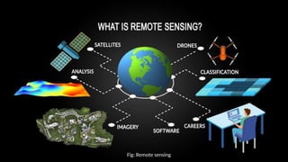
Remote sensing –an introduction
Technique of collecting information about objects or areas
from a distance without physical contact
Used in diverse fields: geography, geology, ecology, glaciology,
hydrology and oceanography
Provides a means of observing large areas at finer spatial and
temporal frequencies
Its integration with GIS enables: Map-based queries, Statistical
analysis and efficient spatial data management
5.
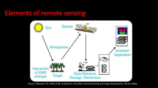
Elements of remotesensing
Source: Lillesand, T.M., Kiefer, R.W., & Chipman, J.W. (2015). Remote Sensing and Image Interpretation, 7th ed., Wiley
6.
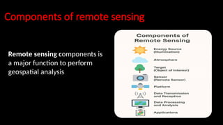
Components of remotesensing
Remote sensing components is
a major function to perform
geospatial analysis
7.
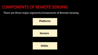
COMPONENTS OF REMOTESENSING
There are three major segments/components of Remote Sensing:
Platforms
Sensors
Orbits
8.
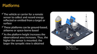
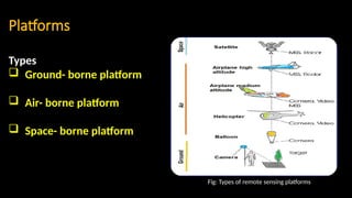
Platforms
The vehicle orcarrier for a remote
sensor to collect and record energy
reflected or emitted from a target or
surface
These platforms can be ground-based,
airborne or space-borne based
As the platform height increases the
observational area increases. Thus, the
higher the sensor is mounted; the
larger the synoptic view is obtained
Fig: Platforms
Source : AI generated
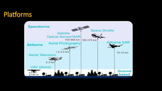
Platforms
There are threetypes of platforms in Remote Sensing-
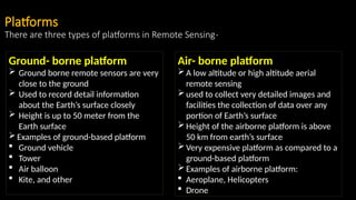
Ground- borne platform
Ground borne remote sensors are very
close to the ground
Used to record detail information
about the Earth’s surface closely
Height is up to 50 meter from the
Earth surface
Examples of ground-based platform
Ground vehicle
Tower
Air balloon
Kite, and other
Air- borne platform
A low altitude or high altitude aerial
remote sensing
used to collect very detailed images and
facilities the collection of data over any
portion of Earth’s surface
Height of the airborne platform is above
50 km from earth’s surface
Very expensive platform as compared to a
ground-based platform
Examples of airborne platform:
Aeroplane, Helicopters
Drone
12.
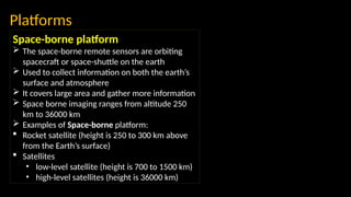
Space-borne platform
Thespace-borne remote sensors are orbiting
spacecraft or space-shuttle on the earth
Used to collect information on both the earth’s
surface and atmosphere
It covers large area and gather more information
Space borne imaging ranges from altitude 250
km to 36000 km
Examples of Space-borne platform:
Rocket satellite (height is 250 to 300 km above
from the Earth’s surface)
Satellites
• low-level satellite (height is 700 to 1500 km)
• high-level satellites (height is 36000 km)
Platforms
13.
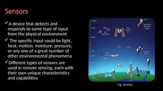
Sensors
A device thatdetects and
responds to some type of input
from the physical environment
The specific input could be light,
heat, motion, moisture, pressure,
or any one of a great number of
other environmental phenomena
Different types of sensors are
used in remote sensing, each with
their own unique characteristics
and capabilities
Fig: Sensors
14.
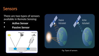
Sensors
There are twotypes of sensors
available in Remote Sensing:
Active Sensor
Passive Sensor
Fig: Types of sensors
15.
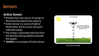
Sensors
Active Sensor
Provide theirown source of energy to
illuminate the objects they observe
Active Sensor is a source of light or
illumination and its sensor measures
reflected energy
The energy is generated and sent from
the Remote sensing platform towards
the targets
RADAR is an example of Active Sensor
Fig: Active sensing
16.
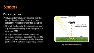
Sensors
Passive sensor
Rely onexternal energy sources, like the
sun, to illuminate the target and then
detect the reflected or emitted radiation
Most of the Remote Sensing systems work
in passive mode using solar energy as the
source of EMR
Most passive systems used in remote
sensing applications operate in the visible,
infrared, thermal infrared, and microwave
portions of the electromagnetic spectrum
Fig: Passive remote sensing
17.
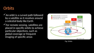
Orbits
An orbit isa curved path followed
by a satellite as it revolves around
a celestial body like Earth
For remote sensing, satellites are
placed in specific orbits to achieve
particular objectives, such as
global coverage or frequent
imaging of specific areas
Fig: Orbits
18.
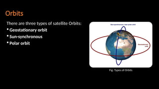
Orbits
There are threetypes of satellite Orbits:
Geostationary orbit
Sun-synchronous
Polar orbit
Fig: Types of Orbits
19.
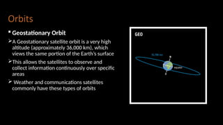
Orbits
Geostationary Orbit
AGeostationary satellite orbit is a very high
altitude (approximately 36,000 km), which
views the same portion of the Earth’s surface
This allows the satellites to observe and
collect information continuously over specific
areas
Weather and communications satellites
commonly have these types of orbits
20.
Orbits
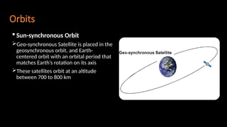
Sun-synchronous Orbit
Geo-synchronousSatellite is placed in the
geosynchronous orbit, and Earth-
centered orbit with an orbital period that
matches Earth’s rotation on its axis
These satellites orbit at an altitude
between 700 to 800 km
21.
Orbits
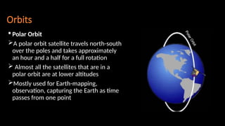
Polar Orbit
Apolar orbit satellite travels north-south
over the poles and takes approximately
an hour and a half for a full rotation
Almost all the satellites that are in a
polar orbit are at lower altitudes
Mostly used for Earth-mapping,
observation, capturing the Earth as time
passes from one point
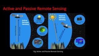
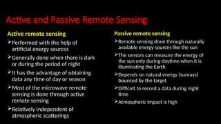
Active and PassiveRemote Sensing
Active remote sensing
Performed with the help of
artificial energy sources
Generally done when there is dark
or during the period of night
It has the advantage of obtaining
data any time of day or season
Most of the microwave remote
sensing is done through active
remote sensing
Relatively independent of
atmospheric scatterings
Passive remote sensing
Remote sensing done through naturally
available energy sources like the sun
The sensors can measure the energy of
the sun only during daytime when it is
illuminating the Earth
Depends on natural energy (sunrays)
bounced by the target
Difficult to record a data during night
time
Atmospheric impact is high
Advantages and Disadvantagesof
Remote Sensing
Advantages
Provides data from large areas
Provides data on very remote and
inaccessible regions
Able to obtain imagery of any area
over a continuous period
Relatively inexpensive when
compared to employing a team of
surveyors
Easy and rapid collection of data
Disadvantages
The interpretation of imagery requires a
certain skill level
Needs cross verification with ground
(field) survey data
Data from multiple sources may create
confusion
Objects can be misclassified or confused
Distortions may occur in an image due to
the relative motion of sensor and source