SlideShare a Scribd company logo
THE CENTER FOR
ADVANCED URBAN
VISIONING
The
Quickway
Proposal
A Rapid Transit Strategy
Optimized for San Diego
OCTOBER 2018
THE CENTER FOR
ADVANCED URBAN
VISIONING
Why are we
planning to invest
over $20 billion
in transit projects?
Shape Regional
Growth
Reduce Pressure
on Parking, Roads
THE CENTER FOR
ADVANCED URBAN
VISIONING
Shape Regional
Growth
Reduce Pressure
on Parking, Roads
For transit to shape
future growth, it must
first effectively serve
the city as it is today.
THE CENTER FOR
ADVANCED URBAN
VISIONING
Shape Regional
Growth
Reduce Pressure
on Parking, Roads
What Matters Most?
1. Travel time
(door to door)
2. Wait time
3. Station design
4. How close to
destinations?
THE CENTER FOR
ADVANCED URBAN
VISIONING
San Diego’s adopted
regional transit plan
looks extensive.
What’s the problem?
THE CENTER FOR
ADVANCED URBAN
VISIONING
Plans
are expressions of
strategies.
What are our current strategies,
and how are they working?
THE CENTER FOR
ADVANCED URBAN
VISIONING
1. Build out a light rail spine.
2. Run “Rapid Buses” on major arterials.
3. Add Express buses to the airport.
4. Build HOV and managed lanes.
Current Transit Strategy
THE CENTER FOR
ADVANCED URBAN
VISIONING
How well is
this working?
THE CENTER FOR
ADVANCED URBAN
VISIONING
1. The Trolley is not attracting large
numbers of people from their cars.
100%
80%
60%
40%
20%
0% 1995 2003
% of Trolley Riders Who “Had an Auto Available” for Their
Trip
2009
Source: SANDAG
Why?
1. Trolley trips still take too long.
2. Stations are often not conveniently located.
3. The overall customer experience is lacking.
2015*
*Beginning with 2015, SANDAG changed the question; results are interpolated.
THE CENTER FOR
ADVANCED URBAN
VISIONING
2. The Trolley is not attracting
the middle-income market.
Source:
SANDAG, “Results of the 2009
Onboard Transit Passenger
Survey for the San Diego
Region,” (February, 2011).
The San Diego
Trolley (light rail)
attracts the
identical low-
income market of
the MTS Bus.
0%
10%
20%
30%
40%
50%
Below
$15k
$15k -
<$25k
$25k -
<$50k
$50k -
<$75k
$75k -
<$100k
$100k
and Up
MTS
Bus
Trolley
Commuter
Rail
Freeway
Bus
Household
Income
THE CENTER FOR
ADVANCED URBAN
VISIONING
3. Too many land uses are not well-served.
¼ Mile Radius
around Trolley
Station
Office
Employment
Mission Valley
Though Mission Valley is one
of the region’s largest office
markets, the vast majority of
office jobs are distant from a
Trolley station.
THE CENTER FOR
ADVANCED URBAN
VISIONING
4. No mode of commuting has
decreased more than carpooling.
-4.3%
-0.7%
-1/3
-1/5
THE CENTER FOR
ADVANCED URBAN
VISIONING
Transit = FAIL!
When the freeway
is blocked:
5. The system lacks resilience
& back-up.
THE CENTER FOR
ADVANCED URBAN
VISIONING
1. Get closer to more people, especially in
denser, walkable, mixed use neighborhoods.
2. Get a lot closer to a lot more jobs.
3. Make transit as fast and direct as possible to
minimize travel times.
4. Minimize wait times.
5. Design stations to provide better protection
from the elements (sun, wind, and rain),
moving vehicles, and other people.
How to Maximize Ridership
THE CENTER FOR
ADVANCED URBAN
VISIONING
The Quickway Strategy
1. Market Research. Understand what attracts transit
riders.
2. Optimized System. Design your “ideal” network to
maximize perceived consumer value.
3. Replicate that System. Using electric Rapid Buses,
begin implementing that network.
4. Build Infrastructure. Direct capital $ to create a
flexible infrastructure that cuts travel time or
otherwise creates a sustainable competitive
advantage.
5. Upgrade. Upgrade modes over time as feasible.
THE CENTER FOR
ADVANCED URBAN
VISIONING
San Diego Quickway Proposal© 2015 by Alan Hoffman 22
So we like stations that feel like real stations, with live information announcing
arrivals, full overhead protection from sun and rain, and sliding glass doors that
match up to the doors on the transit vehicle. Regardless of mode—rail or bus—you
should have the same consistent experience. Mode shouldn’t matter.
1 2 3 4
Vehicledeparts
San Diego Quickway Proposal© 2015 by Alan Hoffman 21
So we like stations that feel like real stations, with live information announcing
arrivals, full overhead protection from sun and rain, and sliding glass doors that
match up to the doors on the transit vehicle. Regardless of mode—rail or bus—you
should have the same consistent experience. Mode shouldn’t matter.
1 2 3 4
Boardvehicle
San Diego Quickway Proposal© 2015 by Alan Hoffman 19
So we like stations that feel like real stations, with live information announcing
arrivals, full overhead protection from sun and rain, and sliding glass doors that
match up to the doors on the transit vehicle. Regardless of mode—rail or bus—you
should have the same consistent experience. Mode shouldn’t matter.
1 2 3 4
Waitingfor vehicle
San Diego Quickway Proposal© 2015 by Alan Hoffman 20
So we like stations that feel like real stations, with live information announcing
arrivals, full overhead protection from sun and rain, and sliding glass doors that
match up to the doors on the transit vehicle. Regardless of mode—rail or bus—you
should have the same consistent experience. Mode shouldn’t matter.
1 2 3 4
Vehiclearrives
THE CENTER FOR
ADVANCED URBAN
VISIONING
San Diego:
Household
Density
Households per Acre
The Trolley largely avoids areas of
high population density. And
though Downtown has developed
a lot of new housing, Trolley
boardings in Downtown haven’t
reflected that growth.
THE CENTER FOR
ADVANCED URBAN
VISIONING
Quickways:
A Flexible
Infrastructure
While most people think of rail—light
rail or metro—when thinking Rapid
Transit, there are real advantages to
creating a grade-separated
infrastructure for rubber-tired vehicles.
Transitways such as Quickways can
support a larger range of routes than
rail, handle a far steeper grade, and
can also be used by emergency
services vehicles such as ambulances.
THE CENTER FOR
ADVANCED URBAN
VISIONINGBrisbane: The Quickway Model
“Brisbane is now at the leading edge in
urban mass transit… the new busway… will attract
international attention for the level of quality and
customer focus that [has been] incorporated.”
— Hans Rat, Secretary General
International Public
Transport Association (IUTP)
THE CENTER FOR
ADVANCED URBAN
VISIONING
This two-lane Quickway in
Australia moves more people in
the peak hour than the busiest
light rail line in all of North
America—and over seven times
as many riders as the busiest
section of the San Diego Trolley!
THE CENTER FOR
ADVANCED URBAN
VISIONING
THE CENTER FOR
ADVANCED URBAN
VISIONING
The use of grade separations
allows this Quickway to locate
stations in optimal locations,
like this one literally built into a
major hospital.
THE CENTER FOR
ADVANCED URBAN
VISIONING
140%
120%
160%
100%
80%
60%
40%
20%
2003 2009
+ 60%
Brisbane: Ridership Growth
2008 Ridership:
Rail: 60 million
Busway: 50 million
2010 Ridership:
Busway: 72 million
Brisbane increased transit ridership by 60%
in six years on the basis of 13 miles of
grade-separated Quickways, while ridership
on their rail network remained flat.
THE CENTER FOR
ADVANCED URBAN
VISIONING
Long-Term Evolution
Quickway segment & station Quickway segment & station
THE CENTER FOR
ADVANCED URBAN
VISIONING
Uncongested roadwayQuickway segment & station Quickway segment & station
Long-Term Evolution
THE CENTER FOR
ADVANCED URBAN
VISIONING
Quickway segment & station Quickway segment & station
Long-Term Evolution
THE CENTER FOR
ADVANCED URBAN
VISIONING
Quickway segment & station Quickway segment & station
Long-Term Evolution
THE CENTER FOR
ADVANCED URBAN
VISIONING
The first generation of
autonomous transit
vehicles is already
commercially available.
THE CENTER FOR
ADVANCED URBAN
VISIONING
What About
Stations?
THE CENTER FOR
ADVANCED URBAN
VISIONING
Cities all over the world have
created attractive Rapid Transit
systems using buses. This station
in Venezuela is an example.
THE CENTER FOR
ADVANCED URBAN
VISIONING
This station mock-up is
from Cape Town, South
Africa.
THE CENTER FOR
ADVANCED URBAN
VISIONING
This station is from the
Rea Vaya BRT network
in Johannesburg,
South Africa
THE CENTER FOR
ADVANCED URBAN
VISIONING
What a great way to
arrive at a destination!
THE CENTER FOR
ADVANCED URBAN
VISIONING
The global standard is to
use sliding doors or
gates to protect children
from moving vehicles.
THE CENTER FOR
ADVANCED URBAN
VISIONING
Phase I:
The San Diego Connected
INTEGRATED GREEN INFRASTRUCTURE
Demonstration Project
What does a Quickway
system look like for San
Diego? The first three
phases have been identified.
THE CENTER FOR
ADVANCED URBAN
VISIONING
UNDERGROUND SEGMENT
MISSION VALLEY QUICKWAY
SURFACE/ELEVATED SEGMENT
UPTOWN QUICKWAY
UNDERGROUND SEGMENT
FreewayDeck
ParkingGarage
6th AveTransit
Corridor
AutoUnderpass
BicycleSpiral
Canyon
Restoration&
Landscapingwith
BikewayBakedIn
Joint Quickway/
GreenwayStructure
THE CENTER FOR
ADVANCED URBAN
VISIONING
© 2017 by The Center for
Advanced Urban Visioning.
All rights reserved.
HistoricStreetcar “Streetcar” Routes,
upgradabletorail
Rapid Bus
Quickway
SuperStation
Trolley
Streetcar
STATION TYPES:
Quickway
Bus Lanes (Surface)
Rapid Bus Route
Bicycle Greenway
Road Tunnel
Streetcar
Trackless Streetcar
INFRASTRUCTURE:
Integrated Green
Infrastructure
30th Street
Streetcar
Corridor
NORTH PARK
SuperStation
HILLCREST CENTER
SuperStation
WASHINGTON STREET
SuperStation
FASHION VALLEY
SuperStation
San Diego
Connected is a
$2.2 billion first
phase (same
budget as the
Mid-Coast Light
Rail Project). It
is designed to
slash travel
time to/from
the new light
rail line, as well
as make transit
competitive in
the core areas
of the region. In
addition to
Quickways, it
includes world-
class bicycle
facilities,
streetcars, and
canyon
restoration.
THE CENTER FOR
ADVANCED URBAN
VISIONING
UNDERGROUND SEGMENT
SURFACE/ELEVATED SEGMENT
UNDERGROUND SEGMENT
Quickways
Grade-Separated Transit
Integrated Green
Infrastructure
HILLCREST
CENTER
FASHION
VALLEY
Mercy
NORTH
PARK
Uptown
District
28th
Esteban Bahena
Albatross
UCSD
Hillcrest
Hotel Circle
Frazee Friars
Mission
Ctr
This phase I project includes the
first 5.5 miles of Quickway in three
segments, of which 2.5 miles of
which is underground, 1.5 miles
elevated, and the rest surface.
Together, these Quickways serve 4
SuperStations, 7 Quickway stations,
and 3 “satellite” station entrances.
THE CENTER FOR
ADVANCED URBAN
VISIONING
HILLCREST CENTER
MERCY
ALBATROSS
Tunnel
Surface
Elevated
Auto Tunnel
Trolley
Shuttle Lane
Bicycle Greenway
LEGEND
Hillcrest is served with a mostly
underground infrastructure
that is integrated with bicycle
and road improvements.
THE CENTER FOR
ADVANCED URBAN
VISIONING
FIVE POINTS
WASHINGTON ST
RENTAL CAR
Tunnel
Surface
Elevated
Bus Lanes
Trolley
Existing Transitway
Rapid Bus Routes
LEGEND
Middletown (Five Points) sees
an upgrade of the Washington
Street station to a
SuperStation, the primary link
to the Mid-Coast Trolley line.
THE CENTER FOR
ADVANCED URBAN
VISIONING
NORTH
PARK
PSA
WABASH
NORTH PARK
SUPERSTATION
Future Streetcar
Tunnel on 30th St
Bilevel Station
Two Surface Stations
~4 Minute Travel Time
Savings at Rush Hour
Tunnel
Busway
Elevated
Bus Lanes
Trolley
Existing Busway
Rapid Bus Routes
LEGEND
THE CENTER FOR
ADVANCED URBAN
VISIONING
UNDERGROUND SEGMENT
SURFACE/ELEVATED SEGMENT
UNDERGROUND SEGMENT
Quickways
Grade-Separated Transit
Integrated Green
Infrastructure
HILLCREST
CENTER
FASHION
VALLEY
Mercy
NORTH
PARK
Uptown
District
28th
Esteban Bahena
Albatross
UCSD
Hillcrest
Hotel Circle
Frazee Friars
Mission
Ctr
Integrated Green
Infrastructure
PILOT PROJECT Rapid Bus
Routes
A large set of electric Rapid Bus
routes use all or part of the new
Quickway infrastructure,
producing real time savings.
THE CENTER FOR
ADVANCED URBAN
VISIONING
58th
College&
University
Aragon
Yale Parks
LaMesa
Springs
Kroc
Ctr
LaMesa
CivicCtr
Acacia LaMesa
Blvd
LaMesa
Village
College
Euclid
BankersHill
CORTEZPLAZA/
DOWNTOWN
GATEWAY
Old Globe/
Museum
of Man
Plazade
Panama
BALBOA PARK
5thAVE
Gaslamp
Central
GASLAMP/
CONVENTIONCTR
Petco Park
PSA
Wabash
Cherokee
Zoo /
Balboa
Park
Naval
Hospital
Mission
Hills
ALBATROSS
WASHINGTON
ST
Comstock
Ulric
Tait E
Genesee
Mary
Birch
Sharp
Memorial
Children’s
Juvenile
Court
Mesa
College
Allied
Health
Kearny
HS
Arizona
UPTOWN
DISTRICT
Texas 30th &
El Cajon
35th
Monroe
University
Hts
Trolley
Barn Pk
Oregon
32nd
Normal
Hts
35th
EMtn
View
NORTH
PARK
CITY
HEIGHTS
BOULEVARD
Laurel /
BalboaPark
Quince
Upas
Winona 54th College
Van
Dyke
City Hts
Village
RosaParks
Manzanita
Olive
Old Town
Morena/
LindaVista
Hazard
Center
Mission
Valley Center
Rio Vista Fenton Parkway
Qualcomm
Stadium
Mission
San Diego
Mission
Valley Rd
Via
Alta Civita
Rio
Bonito
River
Run
HILLCREST
CENTER
FASHION
VALLEY
Polk
Kensington
Aldine
Collwood
Aztec
I-15 &
Adams
SANTAFE
DEPOT
SDSU
Library
Tony
Gwynn
Fault Line
GSt
Police
HQ
16th
22nd
25th
28th
Beech
Cedar
Grape
Juniper
Redwood
Landis
MyrtlePershing
Hawthorne
County Park
CruiseShip
Terminal
Harbor Island
Terminal
1
Terminal
2
SANDIEGO
INTERNATIONAL
AIRPORT
MERCY
UCSD
HILLCREST
HOTEL
CIRCLE
FRAZEE
Park &
Howard
Park &
University
Mission
Center Rd
Avenida
del Rio Siesta
Camino
del Rio N
Centerside
ESTEBAN
BAHENA
I-15
UNIVERSITY AVE
ADAMS AVE
Hilton Sheraton Scottish
Rite
Camino
del Rio S
805 Mission
City
Scheidler
Kearny Mesa/ I-15 to Escondido
7thHorton
Plaza
Justice
Grantville
EL CAJON BLVD
COLLEGEAVE
CAMINO DEL RIO SOUTH
CAMINO DE LA REINA
CAMINO DEL RIO NORTH
RIO SAN DIEGO DR
CIVITA BLVD
30THST
PARKBLVD
P
BICYCLE
GREENWAY
THE CENTER FOR
ADVANCED URBAN
VISIONING
© 2017 by The Center for
Advanced Urban Visioning.
All rights reserved.
ESt
CITY
COLLEGE
Antique
Row
Rental Car
Express to Airport
West of Van Dyke Station,
stops only at SuperStationsFIVE
POINTS
Kearny
Mesa
National City and ChulaVista
Friars
Mission Ctr
La
Mesa
Village
This map depicts
the electric Rapid
Bus (and street-
car) routes that
would use the
new Quickways
(light yellow
background).
Significant travel
time savings and
improved stations
together make
the network far
more attractive
and useful to
potential riders.
Connections to
the Airport,
UTC/UCSD,
Downtown, and
Mission Valley are
especially
improved.
THE CENTER FOR
ADVANCED URBAN
VISIONING
CORTEZPLAZA/
DOWNTOWN
GATEWAY
5thAVE
HILLCREST
CENTER
SANTAFE
DEPOT
P
Terminal
1
Terminal
2
SANDIEGO
INTERNATIONAL
AIRPORT
58th
College&
University
Aragon
Yale Parks
LaMesa
Springs
Kroc
Ctr
LaMesa
CivicCtr
Acacia LaMesa
Blvd
LaMesa
VillageEuclid
City Hts
Village
Van
DykeNORTH
PARK
MIRAMARCOLLEGE
Mira Mesa / ScrippsRanch
SABRESPRINGS/ PEÑASQUITOS
RANCHOBERNARDO
DELLAGO
Westfield North County
ESCONDIDOTRANSITCTR/ SPRINTER
8thSTREET
PLAZABONITA
HSTREET
Downtown
National
City
St.
Matthew’s
4th & Highland
Division
Delta
Plaza& Highland
18th & Highland
24th & Highland
30th & Highland
Brisbane
D& 4th
Rindone/ CivicCtr
Downtown ChulaVista
Sweetwater
Cypress
Broadway
& H
ChulaVistaCtr
/ Scripps
County South
Justice Horton
Plaza
Laurel /
BalboaPk
CITY
HTS
BOULEVARD
WASHINGTON
STREET
FASHION
VALLEY
Kearny
Mesa
Harbor
Island
Rental
Car
In addition to
new electric
Rapid Bus
routes, new
MetroXpress
routes
connects the
I-15 corridor,
Kearny Mesa,
La Mesa/East
County, and
the South Bay
with
destinations
in the core
zone,
including the
airport.
THE CENTER FOR
ADVANCED URBAN
VISIONING
Upon completion of the
first three phases of the
Quickway Proposal, the
proposed MetroXpress
route connecting La
Mesa with Mid-City,
North Park, Hillcrest, the
Mid-Coast Trolley, and
the Airport will feature
extensive grade
separation, dramatically
slashing travel time.
THE CENTER FOR
ADVANCED URBAN
VISIONING
Rapid Bus Station
Quickway Station
SuperStation
Connect to Trolley
Quickway
Bus Lanes (Surface)
Rapid Bus Route
Bicycle Greenway
Road Tunnel
INFRASTRUCTURE: STATION TYPES:
CONNECT TO MID-COAST
The existing
Rapid Bus route
from Escondido
to Downtown
could take
advantage of the
new Quickways
to serve
destinations in
Mission Valley
and Hillcrest, all
while saving
travel time.
THE CENTER FOR
ADVANCED URBAN
VISIONING
BicycleCenter
THE CENTER FOR
ADVANCED URBAN
VISIONING
© 2017 by The Center for
Advanced Urban Visioning.
All rights reserved.
Integrated Green
Infrastructure
Greenways
Landscaped Bikeways with
Gentle Grades and Minimal
Auto/Pedestrian ConflictsA proposed
network of
bicycle
greenways, built
to global
standards
(maximum
sustained grade
of 3%, 7.5’ lanes,
minimal conflict
points), would
make bicycling a
far safer and
easier alternative
for many
thousands of
people.
THE CENTER FOR
ADVANCED URBAN
VISIONING
THE CENTER FOR
ADVANCED URBAN
VISIONING
© 2017 by The Center for
Advanced Urban Visioning.
All rights reserved.
Integrated Green
Infrastructure
PILOT PROJECT
To Airport
To Kensington
North Park 30th Street
Streetcar NetworkThe North Park
Street Car
Network
connects North
Park’s 30th Street
corridor with
University
Heights, Normal
Heights,
Kensington, South
Park, Golden Hill,
the East Village,
Downtown, the
Waterfront, and
the Airport. It
would use a
combination of
rubber-tired and
steel-wheeled
streetcars.
THE CENTER FOR
ADVANCED URBAN
VISIONING
Bicycle Greenway
Cortez Plaza
Transit &
Streetcar Lanes
Rapid Bus and
Streetcar Routes
Transit Station
Transit
Lanes
The “Mend the
Bend” effort to
cap I-5 with new
parklands is
integrated into
the Phase I
projects. A new
transit station,
public plaza,
parking structure,
and civic
buildings
combine to
create an active
and useful new
addition to
Downtown.
THE CENTER FOR
ADVANCED URBAN
VISIONING
GASLAMP CENTRAL
E STREET
Horton Plaza / Balboa Theatre
5TH AVE TROLLEY
ASH ST
GASLAMP /
CONVENTION CTR
Petco Park
Broadway Transit Corridor
6th Avenue
Transit Spine
CORTEZ PLAZA /
DOWNTOWN GATEWAY
6th Avenue Downtown, like
30th Street in North Park, is
budgeted for a complete
rebuild to accommodate
new transit lanes, enhanced
sidewalks, new landscaping,
new transit stations, and
new parking facilities.
THE CENTER FOR
ADVANCED URBAN
VISIONING
Phase II:
The Mid-Coast
Supportive Projects
The Phase II projects
link the new Mid-Coast
Trolley line with
communities to its west.
THE CENTER FOR
ADVANCED URBAN
VISIONING
A combination of Quickway infrastructure,
transit lanes, and other treatments slash
transit travel times to the Trolley from OB,
Mission Beach, and Pacific Beach, as well
as better connecting these communities
with areas served by Phase I projects. New
rapid routes are depicted by dashed lines.
THE CENTER FOR
ADVANCED URBAN
VISIONING
Core Transitways
Bus Lanes
Trolley
Rapid Bus Routes
LEGEND
SuperStation
Station
Rapid Bus Station
Trolley Station
This map depicts rapid
transit routes and infrastruc-
ture in the core urban zones
following the completion of
Phases I and II.
THE CENTER FOR
ADVANCED URBAN
VISIONING
Phase III:
The Sails to Trails
Corridor
The “Sails to Trails” corridor is San Diego’s
historic growth corridor, extending from
Downtown to Mission Trails via El Cajon
Boulevard. Once Phases I and II are completed,
this corridor is slated for massive improvements.
THE CENTER FOR
ADVANCED URBAN
VISIONINGAfter Phases I and
II are completed,
this is what North
Park and Western
Mid-City look like:
some
infrastructure,
but mostly
opportunity.
THE CENTER FOR
ADVANCED URBAN
VISIONINGTHE CENTER FOR
ADVANCED URBAN
VISIONING
THE CENTER FOR
ADVANCED URBAN
VISIONING
THE CENTER FOR
ADVANCED URBAN
VISIONING
1 2
3 4
A series of projects, including road
improvements, gradually extends the
benefits of grade separation along
major sections of El Cajon Boulevard
and University Avenue.
THE CENTER FOR
ADVANCED URBAN
VISIONING
Once completed,
grade separations
(in black) will
produce transit
travel times faster
than driving for
an important set
of transit links.
THE CENTER FOR
ADVANCED URBAN
VISIONING
little transit infrastructureserves these
communities. The “Rapid Bus” Route 215
connects SDSU with downtown via College Ave, El
Cajon Blvd and Park Blvd, though peak-period
travel speeds make this bus only marginally
principal east/west arterials from getting onto
the I-15 busway, mandating transfers for anyone
heading north or south. There are no current
rapid or semi-rapid connections into Mission
Valley.
On the surface, with some traffic
diverted and some replaced with transit
trips, a linear park can be developed
running down the middle of El Cajon
Boulevard, similar to this example from
Copenhagen.
THE CENTER FOR
ADVANCED URBAN
VISIONING
TBD TBD TBD
A “Strategic Investment Zone” extending perhaps 600’ on either side of the proposed transit
and park improvements (which include a major new “Great Park of North Park” and new Mid
City Park), can be defined by a “Form-Based Code” developed in consultation with the
community to organize and concentrate new development around transit, bicycling, and parks.
THE CENTER FOR
ADVANCED URBAN
VISIONING
Following completion of
the first three phases of
Quickway development,
the core of the region
will feature significant
transit infrastructure
capable of slashing travel
times, improving the
customer experience,
and making transit
competitive for a large
set of trips that today
require a car. Future
extensions would feed
off of and into this base
network.
THE CENTER FOR
ADVANCED URBAN
VISIONING
This map depicts the
draft infrastructure of the
Quickway Proposal for
Central and South
County.
THE CENTER FOR
ADVANCED URBAN
VISIONING
This map depicts the
draft infrastructure of the
Quickway Proposal for
North County.
THE CENTER FOR
ADVANCED URBAN
VISIONING
At build-out, the Quickway
Proposal would support an
extensive network of Mainline
(all-stops) and MetroXpress
routes that reach into much of
the region and that makes transit
fully competitive with driving for
many trips.
THE CENTER FOR
ADVANCED URBAN
VISIONING
Outcomes
“Outcomes” means “results.”
How does the Quickway Proposal
compare as a plan with San
Diego’s current adopted plan?
THE CENTER FOR
ADVANCED URBAN
VISIONING
SanDiegoQuickwayProposal –AssemblyDistrict 77© 2015 byAlanHoffman 150
EstimatedCapital Costs
($Billions)
$-
$5
$10
$15
$20
Quickway
Proposal
Existing2050
Plan
$14
$20
$Billions
Note: Figures are
from 2008 and
will need to be
updated.
Estimated Capital Costs (2008)
($ Billions)
The first complete draft of the Quickway Proposal was priced at $14 billion, over 25% cheaper
to build than the current plan. Costs today have risen, but they have risen for both plans.
THE CENTER FOR
ADVANCED URBAN
VISIONING
SanDiegoQuickwayProposal –AssemblyDistrict 77© 2015 byAlanHoffman 151
ProjectedOperatingSubsidiesthrough2050($
Billions)
$11
$14
$19
$-
$5
$10
$15
$20
Quickway
Proposal:
LOW
Quickway
Proposal:
HIGH
Current
2050 Plan
$Billions
Projected Operating Subsidies
through 2050 ($ Billions)
The Quickway Proposal is far more efficient to operate than our current plans.
THE CENTER FOR
ADVANCED URBAN
VISIONING
What About Ridership?
Base Projections
Using 2006 population and trip patterns:
> 240%
Adjusting for 2050 projected population and trip patterns:
~ 400-500% ?
…But even our model did not capture or measure some
of the things we’ve done to maximize ridership.
THE CENTER FOR
ADVANCED URBAN
VISIONING
What About Ridership?
Precedents
An independent analysis by URS (now part of AECom) of a similar
strategy developed for the Metro Atlanta Region found that,
compared to their adopted Transit Plan, the market-focused plan:
Doubled Ridership per Invested Dollar
and also:
Significantly reduced automotive congestion.
THE CENTER FOR
ADVANCED URBAN
VISIONING
Comparative
Performance
This final series of maps compares the Quickway
Proposal (and, in some cases, just the Phase I projects!)
with the current transit plan for area coverage (areas
within ¼ mile of a station) and travel time.
THE CENTER FOR
ADVANCED URBAN
VISIONING
UPTOWN/NORTH PARK/CITY HEIGHTS
RTP 2050 Rapid & Semi-Rapid Transit
Area within ¼ mile radius of:
Rapid Transit station
Semi-Rapid station within 3 stops
of becoming Rapid Transit
Semi-Rapid Transit Station
Streetcar stop
At build-out, the 2050 Regional
Transportation Plan (RTP) calls for light rail
along El Cajon Boulevard, rapid buses
along University Avenue, Adams
Avenue/Park Boulevard, and Bachman
Drive, and streetcars on 30th Street and
making a Hillcrest loop with downtown via
Balboa Park. Since streetcar is generally a
slow mode, it is not counted as rapid or
even semi-rapid transit. While most
residents of these communities will have
access to at least semi-rapid transit,
relatively few will have access to true
Rapid Transit, and for those traveling to
places like Mission Valley or the beach
communities, travel times will still be
excessive.
AC2
LIGHT RAIL
SURFACE BUSWAY
STREETCAR
RAPID BUS
THE CENTER FOR
ADVANCED URBAN
VISIONING
UPTOWN/NORTH PARK/CITY HEIGHTS
Quickway 2025 Rapid & Semi-Rapid Transit
Area within ¼ mile radius of:
Rapid Transit station
Semi-Rapid station within 3 stops
of becoming Rapid Transit
Semi-Rapid Transit Station
Streetcar stop
The first phase of the Quickway Proposal
anticipates the construction of transit
tunnels and other right of way serving the
heart of North Park and connecting the
center of Hillcrest with Mission Valley
(Fashion Valley). These infrastructure
pieces make several Rapid Bus lines
feasible, due to the time savings and
enhanced customer facilities.
True Rapid Transit infrastructure and
stations now serve the major trip
attractors (the two key hospitals as well as
the centers of both North Park and
Hillcrest). Connections to the Trolley are
vastly improved, as well as to much of
Mission Valley. The vast majority of
residents have access to at least semi-rapid
transit.
AC3
TUNNEL
SURFACE BUSWAY
ELEVATED
THE CENTER FOR
ADVANCED URBAN
VISIONING
UPTOWN/NORTH PARK/CITY HEIGHTS
Quickway 2050 Rapid & Semi-Rapid Transit
Area within ¼ mile radius of:
Rapid Transit station
Semi-Rapid station within 3 stops
of becoming Rapid Transit
Semi-Rapid Transit Station
Streetcar stop
In the Quickway Proposal, the majority of
the residents of these densely populated
communities now enjoy access to true
Rapid Transit with routes branching to
many key destinations throughout the
region. Movement within these
communities is also facilitated. A prime
innovation in this network is the use of
automated, self-guiding shuttles to extend
the reach of many Rapid Transit stations
with super-high frequency connections;
the design goal is to treat these as
“horizontal elevators” leading directly into
stations. Designed effectively, these are a
very low-cost means of significantly
improving the effectiveness and
attractiveness of Rapid Transit services to
residents and visitors alike.
AC4
THE CENTER FOR
ADVANCED URBAN
VISIONING
CITY OF SAN DIEGO DISTRICT 7 / KEARNY MESA / LINDA VISTA / CLAIREMONT
RTP 2050 Rapid & Semi-Rapid Transit
Area within ¼ mile radius of:
Rapid Transit station
Semi-Rapid station within 3 stops
of becoming Rapid Transit
Semi-Rapid Transit Station
Streetcar stop
This area is subject to significant new
Rapid Transit and semi-rapid transit in the
RTP. Three Trolley lines are anticipated to
converge in Kearny Mesa. Still, Mission
Valley receives practically no
improvements, and relatively few new
Rapid Transit stations serve residents.
While service is improved relative to
existing services, it still falls far short of
being useful for most residents.
AC6
THE CENTER FOR
ADVANCED URBAN
VISIONING
CITY OF SAN DIEGO DISTRICT 7 / KEARNY MESA / LINDA VISTA / CLAIREMONT
Quickway 2050 Rapid & Semi-Rapid Transit
Area within ¼ mile radius of:
Rapid Transit station
Semi-Rapid station within 3 stops
of becoming Rapid Transit
Semi-Rapid Transit Station
Streetcar stop
The full Quickway Proposal for this zone
shows extensive coverage; virtually all of
Mission Valley and Kearny Mesa enjoy
access to Rapid Transit, as well as
enhanced portions of Clairemont and
Tierrasanta, while other communities
enjoy more extensive access to semi-rapid
transit that is well-integrated with the
Rapid Transit network. Large numbers of
residents have access to this system.
AC8
THE CENTER FOR
ADVANCED URBAN
VISIONING
NATIONAL CITY & SOUTHEAST COMMUNITIES
RTP 2050 Rapid & Semi-Rapid Transit
Area within ¼ mile radius of:
Rapid Transit station
Semi-Rapid station within 3 stops
of becoming Rapid Transit
Semi-Rapid Transit Station
Streetcar stop
A new light rail line, the Purple Line, is
proposed by SANDAG to run through the
heart of the South Bay cities, through Mid-
City San Diego, and into Kearny Mesa.
Access to Rapid or Semi-Rapid Transit still
remains somewhat limited, and the Purple
Line will not make travel to points west
easy or quick.
AC15
THE CENTER FOR
ADVANCED URBAN
VISIONING
NATIONAL CITY & SOUTHEAST COMMUNITIES
Quickway 2050 Rapid & Semi-Rapid Transit
Area within ¼ mile radius of:
Rapid Transit station
Semi-Rapid station within 3 stops
of becoming Rapid Transit
Semi-Rapid Transit Station
Streetcar stop
The Quickway Proposal anticipates a more
flexible set of infrastructure investments
that about double effective access to
Rapid or semi-rapid transit.
Travel times to many key destinations are
significantly improved in the Quickway
Proposal, easing access to far more of the
region’s job opportunities.
AC16
THE CENTER FOR
ADVANCED URBAN
VISIONING
NATIONAL CITY & SOUTHEAST COMMUNITIES
RTP 2050 Rapid & Semi-Rapid Transit
Area within ¼ mile radius of:
Rapid Transit station
Semi-Rapid station within 3 stops
of becoming Rapid Transit
Semi-Rapid Transit Station
Streetcar stop
The RTP anticipates a new Trolley line, the
Purple Line, traveling through the heart of
Chula Vista, and a new Rapid Bus line on
the H Street corridor.
Though both will be useful additions
compared to current services, most
residents remain beyond walking access
from Rapid or semi-rapid transit.
AC18
THE CENTER FOR
ADVANCED URBAN
VISIONING
NATIONAL CITY & SOUTHEAST COMMUNITIES
Quickway 2050 Rapid & Semi-Rapid Transit
Area within ¼ mile radius of:
Rapid Transit station
Semi-Rapid station within 3 stops
of becoming Rapid Transit
Semi-Rapid Transit Station
Streetcar stop
Compared to the RTP, the Quickway
Proposal extends access to both Rapid and
semi-rapid Transit to a much larger share
of Chula Vista’s residents and destinations.
Travel times within Chula Vista are
improved, as well as access to regional
destinations, most of which will be
brought much closer to Chula Vista.
AC19
THE CENTER FOR
ADVANCED URBAN
VISIONING
Base map: “2050 Housing
and Employment Densities
and Urban Area Transit
Strategy Boundary”
(SANDAG, San Diego
Forward: The Regional
Plan, 2016, p. 37).
RTP 2050 Stations
within
of Fashion Valley
Matched to
2050 Employment
& Housing
Densities
CENTRAL SAN DIEGO
While many of the
stations that are within 30
minutes by transit of
Fashion Valley in the RTP
are surrounded by jobs,
they represent only a
small portion of the jobs
in the central zone.
TT7
THE CENTER FOR
ADVANCED URBAN
VISIONING
Base map: “2050 Housing
and Employment Densities
and Urban Area Transit
Strategy Boundary”
(SANDAG, San Diego
Forward: The Regional
Plan, 2016, p. 37).
Quickway Stations
within
of Fashion Valley
Matched to
2050 Employment
& Housing
Densities
CENTRAL SAN DIEGO
The Quickway Proposal
brings many more jobs
and residences closer to
Fashion Valley than the
RTP. Similar results may
be expected for most
locations in the region.
Why wouldn’t we pursue
a strategy that provides
superior connectivity?
TT8
THE CENTER FOR
ADVANCED URBAN
VISIONING
PLEASE NOTE: THESE MAPS ARE APPROXIMATE DEPICTIONS.
2050 RTP
PLEASE NOTE: THESE MAPS ARE APPROXIMATE DEPICTIONS. TRAVEL TIMES CALCULATED FOR WEEKDAY COMMUTE, ARRIVAL BY 8:30 AM.
TT9
MISSION VALLEY
RTP 2050 Stations within 10 Minutes of Fashion Valley
The only real improvements planned for
Mission Valley in the RTP are Rapid Bus lines to
Linda Vista and Hillcrest. Otherwise, most of
Mission Valley, including most office
employment and most residents, are not
directly served.
Travel times to Fashion Valley during the AM
commute were calculated for both the RTP
and the Quickway Proposal.
Fashion Valley was chosen as a destination due
to its centrality in the region and its
importance as a transfer center.
THE CENTER FOR
ADVANCED URBAN
VISIONING
2050 RTP
PLEASE NOTE: THESE MAPS ARE APPROXIMATE DEPICTIONS. TRAVEL TIMES CALCULATED FOR WEEKDAY COMMUTE, ARRIVAL BY 8:30 AM.
TT11
MISSION VALLEY
RTP 2050 Stations within of Fashion Valley
Very few additional stations are brought within
20 minutes of Fashion Valley compared to 10
minutes in the RTP 2050 Transit Plan. Most of
the office jobs and residences in Mission Valley
are not within ¼ mile of Rapid or semi-rapid
transit.
Travel times to Fashion Valley during the AM
commute were calculated for both the RTP
and the Quickway Proposal.
Fashion Valley was chosen as a destination due
to its centrality in the region and its
importance as a transfer center.
THE CENTER FOR
ADVANCED URBAN
VISIONING
Quickway Proposal
PLEASE NOTE: THESE MAPS ARE APPROXIMATE DEPICTIONS. TRAVEL TIMES CALCULATED FOR WEEKDAY COMMUTE, ARRIVAL BY 8:30 AM.
10MINUTES
TT10
MISSION VALLEY
Quickway 2050 Stations within 10 Minutes of Fashion Valley
The Quickway Proposal specifies infrastructure
to speed transit services into, out of, and
through Mission Valley. Large areas of both
Mission Valley and surrounding communities
(North Park, Hillcrest, and Linda Vista) and
brought wihin 10 minutes of Fashion Valley.
Travel times to Fashion Valley during the AM
commute were calculated for both the RTP
and the Quickway Proposal.
Fashion Valley was chosen as a destination due
to its centrality in the region and its
importance as a transfer center.
THE CENTER FOR
ADVANCED URBAN
VISIONING
Quickway Proposal
PLEASE NOTE: THESE MAPS ARE APPROXIMATE DEPICTIONS. TRAVEL TIMES CALCULATED FOR WEEKDAY COMMUTE, ARRIVAL BY 8:30 AM.
TT12
MISSION VALLEY
Quickway 2050 Stations within of Fashion Valley
The vast majority of Mission Valley is within 20
minutes of Fashion Valley in the Quickway
Proposal, as well as much of North Park,
University Heights, Normal Heights, Linda
Vista, and other nearby communities. The
combination of faster travel times and much
broader area coverage make the Quickway
network more useful to more people.
Travel times to Fashion Valley during the AM
commute were calculated for both the RTP
and the Quickway Proposal.
Fashion Valley was chosen as a destination due
to its centrality in the region and its
importance as a transfer center.
20MINUTES
THE CENTER FOR
ADVANCED URBAN
VISIONING
Kearny
Mesa
QUICKWAY PROPOSAL
From no part of Kearny Mesa does
rapid or semi-rapid transit get you to
Fashion Valley in 10 minutes or less
during the AM commute.
The Sharp Hospital District, much of
Convoy, and even Clairemont Mesa
Boulevard are within 10 minutes of
Fashion Valley.
SANDAG RTP 2050 PLAN
Areas
within
10MINUTES
by Rapid
or Semi-
Rapid
Transit
of the
Fashion
Valley
Transit
Station
PLEASE NOTE: THESE MAPS ARE APPROXIMATE DEPICTIONS. TRAVEL TIMES CALCULATED FOR WEEKDAY COMMUTE, ARRIVAL BY 8:30 AM.
KEARNY MESA
Station Areas within 10 minutes of Fashion Valley:
SANDAG 2050 RTP Plan vs the Quickway Proposal
TT14
THE CENTER FOR
ADVANCED URBAN
VISIONING
Most of Kearny Mesa, parts of
Clairemont and Serra Mesa, and Mesa
College are all within 20 minutes of
Fashion Valley.
The northern part of the Sharp
Hospital District and a busy corner in
Kearny Mesa are within 20 minutes of
Fashion Valley.
Kearny
Mesa
QUICKWAY PROPOSALSANDAG RTP 2050 PLAN
Areas
within
by Rapid
or Semi-
Rapid
Transit
of the
Fashion
Valley
Transit
Station
PLEASE NOTE: THESE MAPS ARE APPROXIMATE DEPICTIONS. TRAVEL TIMES CALCULATED FOR WEEKDAY COMMUTE, ARRIVAL BY 8:30 AM.
KEARNY MESA
Station Areas within of Fashion Valley:
SANDAG 2050 RTP Plan vs the Quickway Proposal
TT15
THE CENTER FOR
ADVANCED URBAN
VISIONING
Kearny
Mesa
QUICKWAY PROPOSAL
Some locations in Kearny Mesa are
now within a 30 minute rapid or semi-
rapid transit trip of Fashion Valley.
Most of the rest of Kearny Mesa
is now served.
SANDAG RTP 2050 PLAN
Areas
within
by Rapid
or Semi-
Rapid
Transit
of the
Fashion
Valley
Transit
Station
PLEASE NOTE: THESE MAPS ARE APPROXIMATE DEPICTIONS. TRAVEL TIMES CALCULATED FOR WEEKDAY COMMUTE, ARRIVAL BY 8:30 AM.
KEARNY MESA
Station Areas within of Fashion Valley:
SANDAG 2050 RTP Plan vs the Quickway Proposal
TT16
THE CENTER FOR
ADVANCED URBAN
VISIONING
Travel Times
NORTH COUNTY
78
6
75
8
22
9
62
29
17
8
49
15
92
13
88
9
28
11 66
17
51
26
74
34
41
27
35
1264
26
Average Travel Times:
CURRENT TRANSIT:
56.1Mins.
QUICKWAY TRANSIT:
16.7 Mins.
Travel time savings in
North County average
70%, though in some
cases this is because
of the lack of current
transit options. Even
so, many transit times
become competitive
with driving under the
Quickway Proposal.
NORTH COUNTY
Quickway Proposal Projected Travel Times
vs Current Transit Travel TImes
TT17
Please note: Travel times
calculated in 2014. Ongoing
improvements to both the current
network and the Quickway
Proposal may have shifted some
times (for example, current travel
time from the Escondido Transit
Center to Sorrento Mesa has been
reduced from 62 to 61 minutes).
THE CENTER FOR
ADVANCED URBAN
VISIONING
Travel Times (Minutes)
21
8
5
2 19
12
44
10
10
4
21
7
29
11
7
3
12
529
13
3
3
33
5
7
524
14
46
9
20
12
32
14
15
14
17
17
18
5
19
4 14
8
26
12
12
8
22
9
21
7
11
4 12
4
25
15
54
20
38
13
QUICKWAY TRANSIT: 9.1 Mins.
CURRENT TRANSIT: 22.2Mins.
18
5
39
18
22
9
CENTRAL
Average Travel Times:
CENTRAL & EAST COUNTY
Quickway Proposal Projected Travel Times
vs Current Transit Travel TImes
TT18
THE CENTER FOR
ADVANCED URBAN
VISIONING
Travel Times
SOUTH BAY
9
7
7
8
12
20
6
2
6
12
7
15
7
20
13
16
55
7
18
22
35
19
41
45
29
44 66
12
Average Travel Times:
CURRENT TRANSIT:
30.1Mins.
QUICKWAY TRANSIT:
9.9 Mins.
BEST DRIVING TIME:
9.1 Mins.
SOUTH COUNTY
Quickway Proposal Projected Travel Times
vs Current Transit Travel TImes
TT19
THE CENTER FOR
ADVANCED URBAN
VISIONING
Ridership
Compared to the RTP, the Quickway Proposal is designed to
attract higher ridership by creating more value for more people.
The QP connects many more people with many more likely
destinations more directly in far less time and with a more
customer-friendly station-based interface.
The QP is designed to attract far more “Transit-Oriented
Development” than the RTP by placing transit infrastructure
and services precisely in areas with high market demand.
Parallel world-class bicycle Greenways further enhance modal
shift from cars.
THE CENTER FOR
ADVANCED URBAN
VISIONING
Conclusion
The combo of higher ridership + more TOD = significant
reductions in ghg emissions relative to the auto-centric RTP.
Because the benefits of Quickways extend many miles from the
actual guideways, more of the region can be connected more
effectively in less time for the same level of resources.
By maximizing consumer value, the QP can better use value
capture mechanisms such as IFDs to help finance the program.
Modal shift to bicycling, transit, and walking, is significant.
Total capital costs of the QP are likely lower than the RTP, but
return on investment is much higher. Any rejection of the QP
due to costs is not based on transparent and fair analysis.
THE CENTER FOR
ADVANCED URBAN
VISIONING
TO SUPPORT OUR WORK,
PLEASE VISIT:
www.GoFundMe.com/Quickwaywww.GoFundMe.com/Quickway

More Related Content

Similar to 2018 San Diego Quickway Presentation

Introducing the Quickway Proposal - A Vision for a World-Class Transit System...
Introducing the Quickway Proposal - A Vision for a World-Class Transit System...Introducing the Quickway Proposal - A Vision for a World-Class Transit System...
Introducing the Quickway Proposal - A Vision for a World-Class Transit System...
Alan Hoffman
 
QuickwayProposalIntro
QuickwayProposalIntroQuickwayProposalIntro
QuickwayProposalIntro
Alan Hoffman
 
Moving-About-Paradise
Moving-About-ParadiseMoving-About-Paradise
Moving-About-Paradise
Alan Hoffman
 
pt 2: The Quickway Proposal: How to Create a World-Class Transit System
pt 2: The Quickway Proposal: How to Create a World-Class Transit Systempt 2: The Quickway Proposal: How to Create a World-Class Transit System
pt 2: The Quickway Proposal: How to Create a World-Class Transit System
Alan Hoffman
 
Nico de luis coll mob conf pres
Nico de luis coll mob conf   presNico de luis coll mob conf   pres
Nico de luis coll mob conf pres
Antonia Roberts
 
VTA's Next Network: Your Transit Choices
VTA's Next Network: Your Transit ChoicesVTA's Next Network: Your Transit Choices
VTA's Next Network: Your Transit Choices
SCVTA
 
Montgomery County And Transit (revised)
Montgomery County And Transit (revised)Montgomery County And Transit (revised)
Montgomery County And Transit (revised)
Richard Layman
 
Tick mobility
Tick mobilityTick mobility
Tick mobility
Christian Shpilka
 
April 9 VTA Mountain View Open House project display boards
April 9 VTA Mountain View Open House project display boardsApril 9 VTA Mountain View Open House project display boards
April 9 VTA Mountain View Open House project display boards
SCVTA
 
Future Streets
Future StreetsFuture Streets
Future Streets
John Smith
 
San Francisco Smart City Challenge
San Francisco Smart City Challenge San Francisco Smart City Challenge
San Francisco Smart City Challenge
Urban SDK
 
Pedestrian planning and modelling
Pedestrian planning and modellingPedestrian planning and modelling
Pedestrian planning and modelling
Institute for Transport Studies (ITS)
 
Aerial Transit in San Francisco
Aerial Transit in San FranciscoAerial Transit in San Francisco
Aerial Transit in San Francisco
Stuart Tett
 
Multimodal in rail development: popularity and reaping benefits
Multimodal in rail development: popularity and reaping benefitsMultimodal in rail development: popularity and reaping benefits
Multimodal in rail development: popularity and reaping benefits
Atkins
 
Portfolio Melina Christina
Portfolio Melina ChristinaPortfolio Melina Christina
Portfolio Melina Christina
Melina CHRISTINA
 
A STUDY ON PROVISION OF PARK AND RIDE FACILITY FOR SMART CITY BELAGAVI
A STUDY ON PROVISION OF PARK AND RIDE FACILITY FOR SMART CITY BELAGAVIA STUDY ON PROVISION OF PARK AND RIDE FACILITY FOR SMART CITY BELAGAVI
A STUDY ON PROVISION OF PARK AND RIDE FACILITY FOR SMART CITY BELAGAVI
IRJET Journal
 
Webinar: Smart Cities
Webinar: Smart CitiesWebinar: Smart Cities
Webinar: Smart Cities
IEBSchool
 
Transit-oriented development (TOD): Integrating rail and commercial developme...
Transit-oriented development (TOD): Integrating rail and commercial developme...Transit-oriented development (TOD): Integrating rail and commercial developme...
Transit-oriented development (TOD): Integrating rail and commercial developme...
Atkins
 
Autonomous vehicles and impact on cities
Autonomous vehicles and impact on citiesAutonomous vehicles and impact on cities
Autonomous vehicles and impact on cities
Institute for Transport Studies (ITS)
 

Similar to 2018 San Diego Quickway Presentation (20)

Introducing the Quickway Proposal - A Vision for a World-Class Transit System...
Introducing the Quickway Proposal - A Vision for a World-Class Transit System...Introducing the Quickway Proposal - A Vision for a World-Class Transit System...
Introducing the Quickway Proposal - A Vision for a World-Class Transit System...
 
QuickwayProposalIntro
QuickwayProposalIntroQuickwayProposalIntro
QuickwayProposalIntro
 
Moving-About-Paradise
Moving-About-ParadiseMoving-About-Paradise
Moving-About-Paradise
 
pt 2: The Quickway Proposal: How to Create a World-Class Transit System
pt 2: The Quickway Proposal: How to Create a World-Class Transit Systempt 2: The Quickway Proposal: How to Create a World-Class Transit System
pt 2: The Quickway Proposal: How to Create a World-Class Transit System
 
Nico de luis coll mob conf pres
Nico de luis coll mob conf   presNico de luis coll mob conf   pres
Nico de luis coll mob conf pres
 
VTA's Next Network: Your Transit Choices
VTA's Next Network: Your Transit ChoicesVTA's Next Network: Your Transit Choices
VTA's Next Network: Your Transit Choices
 
Montgomery County And Transit (revised)
Montgomery County And Transit (revised)Montgomery County And Transit (revised)
Montgomery County And Transit (revised)
 
Tick mobility
Tick mobilityTick mobility
Tick mobility
 
April 9 VTA Mountain View Open House project display boards
April 9 VTA Mountain View Open House project display boardsApril 9 VTA Mountain View Open House project display boards
April 9 VTA Mountain View Open House project display boards
 
Future Streets
Future StreetsFuture Streets
Future Streets
 
San Francisco Smart City Challenge
San Francisco Smart City Challenge San Francisco Smart City Challenge
San Francisco Smart City Challenge
 
Pedestrian planning and modelling
Pedestrian planning and modellingPedestrian planning and modelling
Pedestrian planning and modelling
 
Aerial Transit in San Francisco
Aerial Transit in San FranciscoAerial Transit in San Francisco
Aerial Transit in San Francisco
 
Multimodal in rail development: popularity and reaping benefits
Multimodal in rail development: popularity and reaping benefitsMultimodal in rail development: popularity and reaping benefits
Multimodal in rail development: popularity and reaping benefits
 
Portfolio Melina Christina
Portfolio Melina ChristinaPortfolio Melina Christina
Portfolio Melina Christina
 
A STUDY ON PROVISION OF PARK AND RIDE FACILITY FOR SMART CITY BELAGAVI
A STUDY ON PROVISION OF PARK AND RIDE FACILITY FOR SMART CITY BELAGAVIA STUDY ON PROVISION OF PARK AND RIDE FACILITY FOR SMART CITY BELAGAVI
A STUDY ON PROVISION OF PARK AND RIDE FACILITY FOR SMART CITY BELAGAVI
 
Webinar: Smart Cities
Webinar: Smart CitiesWebinar: Smart Cities
Webinar: Smart Cities
 
2016 TOD brochure
2016 TOD brochure2016 TOD brochure
2016 TOD brochure
 
Transit-oriented development (TOD): Integrating rail and commercial developme...
Transit-oriented development (TOD): Integrating rail and commercial developme...Transit-oriented development (TOD): Integrating rail and commercial developme...
Transit-oriented development (TOD): Integrating rail and commercial developme...
 
Autonomous vehicles and impact on cities
Autonomous vehicles and impact on citiesAutonomous vehicles and impact on cities
Autonomous vehicles and impact on cities
 

Recently uploaded

一比一原版(NCL毕业证书)纽卡斯尔大学毕业证成绩单如何办理
一比一原版(NCL毕业证书)纽卡斯尔大学毕业证成绩单如何办理一比一原版(NCL毕业证书)纽卡斯尔大学毕业证成绩单如何办理
一比一原版(NCL毕业证书)纽卡斯尔大学毕业证成绩单如何办理
7sd8fier
 
Can AI do good? at 'offtheCanvas' India HCI prelude
Can AI do good? at 'offtheCanvas' India HCI preludeCan AI do good? at 'offtheCanvas' India HCI prelude
Can AI do good? at 'offtheCanvas' India HCI prelude
Alan Dix
 
一比一原版(LSE毕业证书)伦敦政治经济学院毕业证成绩单如何办理
一比一原版(LSE毕业证书)伦敦政治经济学院毕业证成绩单如何办理一比一原版(LSE毕业证书)伦敦政治经济学院毕业证成绩单如何办理
一比一原版(LSE毕业证书)伦敦政治经济学院毕业证成绩单如何办理
jyz59f4j
 
PORTFOLIO FABIANA VILLANI ARCHITECTURE.pdf
PORTFOLIO FABIANA VILLANI ARCHITECTURE.pdfPORTFOLIO FABIANA VILLANI ARCHITECTURE.pdf
PORTFOLIO FABIANA VILLANI ARCHITECTURE.pdf
fabianavillanib
 
一比一原版(Glasgow毕业证书)格拉斯哥大学毕业证成绩单如何办理
一比一原版(Glasgow毕业证书)格拉斯哥大学毕业证成绩单如何办理一比一原版(Glasgow毕业证书)格拉斯哥大学毕业证成绩单如何办理
一比一原版(Glasgow毕业证书)格拉斯哥大学毕业证成绩单如何办理
n0tivyq
 
一比一原版(毕业证)长崎大学毕业证成绩单如何办理
一比一原版(毕业证)长崎大学毕业证成绩单如何办理一比一原版(毕业证)长崎大学毕业证成绩单如何办理
一比一原版(毕业证)长崎大学毕业证成绩单如何办理
taqyed
 
一比一原版(UAL毕业证书)伦敦艺术大学毕业证成绩单如何办理
一比一原版(UAL毕业证书)伦敦艺术大学毕业证成绩单如何办理一比一原版(UAL毕业证书)伦敦艺术大学毕业证成绩单如何办理
一比一原版(UAL毕业证书)伦敦艺术大学毕业证成绩单如何办理
708pb191
 
RTUYUIJKLDSADAGHBDJNKSMAL,D
RTUYUIJKLDSADAGHBDJNKSMAL,DRTUYUIJKLDSADAGHBDJNKSMAL,D
RTUYUIJKLDSADAGHBDJNKSMAL,D
cy0krjxt
 
原版定做(penn毕业证书)美国宾夕法尼亚大学毕业证文凭学历证书原版一模一样
原版定做(penn毕业证书)美国宾夕法尼亚大学毕业证文凭学历证书原版一模一样原版定做(penn毕业证书)美国宾夕法尼亚大学毕业证文凭学历证书原版一模一样
原版定做(penn毕业证书)美国宾夕法尼亚大学毕业证文凭学历证书原版一模一样
gpffo76j
 
Let's Summon Demons Shirt Let's Summon Demons Shirt
Let's Summon Demons Shirt Let's Summon Demons ShirtLet's Summon Demons Shirt Let's Summon Demons Shirt
Let's Summon Demons Shirt Let's Summon Demons Shirt
TeeFusion
 
Top Israeli Products and Brands - Plan it israel.pdf
Top Israeli Products and Brands - Plan it israel.pdfTop Israeli Products and Brands - Plan it israel.pdf
Top Israeli Products and Brands - Plan it israel.pdf
PlanitIsrael
 
一比一原版(BU毕业证书)伯恩茅斯大学毕业证成绩单如何办理
一比一原版(BU毕业证书)伯恩茅斯大学毕业证成绩单如何办理一比一原版(BU毕业证书)伯恩茅斯大学毕业证成绩单如何办理
一比一原版(BU毕业证书)伯恩茅斯大学毕业证成绩单如何办理
h7j5io0
 
Expert Accessory Dwelling Unit (ADU) Drafting Services
Expert Accessory Dwelling Unit (ADU) Drafting ServicesExpert Accessory Dwelling Unit (ADU) Drafting Services
Expert Accessory Dwelling Unit (ADU) Drafting Services
ResDraft
 
一比一原版(RHUL毕业证书)伦敦大学皇家霍洛威学院毕业证如何办理
一比一原版(RHUL毕业证书)伦敦大学皇家霍洛威学院毕业证如何办理一比一原版(RHUL毕业证书)伦敦大学皇家霍洛威学院毕业证如何办理
一比一原版(RHUL毕业证书)伦敦大学皇家霍洛威学院毕业证如何办理
9a93xvy
 
一比一原版(UCB毕业证书)伯明翰大学学院毕业证成绩单如何办理
一比一原版(UCB毕业证书)伯明翰大学学院毕业证成绩单如何办理一比一原版(UCB毕业证书)伯明翰大学学院毕业证成绩单如何办理
一比一原版(UCB毕业证书)伯明翰大学学院毕业证成绩单如何办理
h7j5io0
 
Book Formatting: Quality Control Checks for Designers
Book Formatting: Quality Control Checks for DesignersBook Formatting: Quality Control Checks for Designers
Book Formatting: Quality Control Checks for Designers
Confidence Ago
 
Borys Sutkowski portfolio interior design
Borys Sutkowski portfolio interior designBorys Sutkowski portfolio interior design
Borys Sutkowski portfolio interior design
boryssutkowski
 
一比一原版(MMU毕业证书)曼彻斯特城市大学毕业证成绩单如何办理
一比一原版(MMU毕业证书)曼彻斯特城市大学毕业证成绩单如何办理一比一原版(MMU毕业证书)曼彻斯特城市大学毕业证成绩单如何办理
一比一原版(MMU毕业证书)曼彻斯特城市大学毕业证成绩单如何办理
7sd8fier
 
vernacular architecture in response to climate.pdf
vernacular architecture in response to climate.pdfvernacular architecture in response to climate.pdf
vernacular architecture in response to climate.pdf
PrabhjeetSingh219035
 
Design Thinking Design thinking Design thinking
Design Thinking Design thinking Design thinkingDesign Thinking Design thinking Design thinking
Design Thinking Design thinking Design thinking
cy0krjxt
 

Recently uploaded (20)

一比一原版(NCL毕业证书)纽卡斯尔大学毕业证成绩单如何办理
一比一原版(NCL毕业证书)纽卡斯尔大学毕业证成绩单如何办理一比一原版(NCL毕业证书)纽卡斯尔大学毕业证成绩单如何办理
一比一原版(NCL毕业证书)纽卡斯尔大学毕业证成绩单如何办理
 
Can AI do good? at 'offtheCanvas' India HCI prelude
Can AI do good? at 'offtheCanvas' India HCI preludeCan AI do good? at 'offtheCanvas' India HCI prelude
Can AI do good? at 'offtheCanvas' India HCI prelude
 
一比一原版(LSE毕业证书)伦敦政治经济学院毕业证成绩单如何办理
一比一原版(LSE毕业证书)伦敦政治经济学院毕业证成绩单如何办理一比一原版(LSE毕业证书)伦敦政治经济学院毕业证成绩单如何办理
一比一原版(LSE毕业证书)伦敦政治经济学院毕业证成绩单如何办理
 
PORTFOLIO FABIANA VILLANI ARCHITECTURE.pdf
PORTFOLIO FABIANA VILLANI ARCHITECTURE.pdfPORTFOLIO FABIANA VILLANI ARCHITECTURE.pdf
PORTFOLIO FABIANA VILLANI ARCHITECTURE.pdf
 
一比一原版(Glasgow毕业证书)格拉斯哥大学毕业证成绩单如何办理
一比一原版(Glasgow毕业证书)格拉斯哥大学毕业证成绩单如何办理一比一原版(Glasgow毕业证书)格拉斯哥大学毕业证成绩单如何办理
一比一原版(Glasgow毕业证书)格拉斯哥大学毕业证成绩单如何办理
 
一比一原版(毕业证)长崎大学毕业证成绩单如何办理
一比一原版(毕业证)长崎大学毕业证成绩单如何办理一比一原版(毕业证)长崎大学毕业证成绩单如何办理
一比一原版(毕业证)长崎大学毕业证成绩单如何办理
 
一比一原版(UAL毕业证书)伦敦艺术大学毕业证成绩单如何办理
一比一原版(UAL毕业证书)伦敦艺术大学毕业证成绩单如何办理一比一原版(UAL毕业证书)伦敦艺术大学毕业证成绩单如何办理
一比一原版(UAL毕业证书)伦敦艺术大学毕业证成绩单如何办理
 
RTUYUIJKLDSADAGHBDJNKSMAL,D
RTUYUIJKLDSADAGHBDJNKSMAL,DRTUYUIJKLDSADAGHBDJNKSMAL,D
RTUYUIJKLDSADAGHBDJNKSMAL,D
 
原版定做(penn毕业证书)美国宾夕法尼亚大学毕业证文凭学历证书原版一模一样
原版定做(penn毕业证书)美国宾夕法尼亚大学毕业证文凭学历证书原版一模一样原版定做(penn毕业证书)美国宾夕法尼亚大学毕业证文凭学历证书原版一模一样
原版定做(penn毕业证书)美国宾夕法尼亚大学毕业证文凭学历证书原版一模一样
 
Let's Summon Demons Shirt Let's Summon Demons Shirt
Let's Summon Demons Shirt Let's Summon Demons ShirtLet's Summon Demons Shirt Let's Summon Demons Shirt
Let's Summon Demons Shirt Let's Summon Demons Shirt
 
Top Israeli Products and Brands - Plan it israel.pdf
Top Israeli Products and Brands - Plan it israel.pdfTop Israeli Products and Brands - Plan it israel.pdf
Top Israeli Products and Brands - Plan it israel.pdf
 
一比一原版(BU毕业证书)伯恩茅斯大学毕业证成绩单如何办理
一比一原版(BU毕业证书)伯恩茅斯大学毕业证成绩单如何办理一比一原版(BU毕业证书)伯恩茅斯大学毕业证成绩单如何办理
一比一原版(BU毕业证书)伯恩茅斯大学毕业证成绩单如何办理
 
Expert Accessory Dwelling Unit (ADU) Drafting Services
Expert Accessory Dwelling Unit (ADU) Drafting ServicesExpert Accessory Dwelling Unit (ADU) Drafting Services
Expert Accessory Dwelling Unit (ADU) Drafting Services
 
一比一原版(RHUL毕业证书)伦敦大学皇家霍洛威学院毕业证如何办理
一比一原版(RHUL毕业证书)伦敦大学皇家霍洛威学院毕业证如何办理一比一原版(RHUL毕业证书)伦敦大学皇家霍洛威学院毕业证如何办理
一比一原版(RHUL毕业证书)伦敦大学皇家霍洛威学院毕业证如何办理
 
一比一原版(UCB毕业证书)伯明翰大学学院毕业证成绩单如何办理
一比一原版(UCB毕业证书)伯明翰大学学院毕业证成绩单如何办理一比一原版(UCB毕业证书)伯明翰大学学院毕业证成绩单如何办理
一比一原版(UCB毕业证书)伯明翰大学学院毕业证成绩单如何办理
 
Book Formatting: Quality Control Checks for Designers
Book Formatting: Quality Control Checks for DesignersBook Formatting: Quality Control Checks for Designers
Book Formatting: Quality Control Checks for Designers
 
Borys Sutkowski portfolio interior design
Borys Sutkowski portfolio interior designBorys Sutkowski portfolio interior design
Borys Sutkowski portfolio interior design
 
一比一原版(MMU毕业证书)曼彻斯特城市大学毕业证成绩单如何办理
一比一原版(MMU毕业证书)曼彻斯特城市大学毕业证成绩单如何办理一比一原版(MMU毕业证书)曼彻斯特城市大学毕业证成绩单如何办理
一比一原版(MMU毕业证书)曼彻斯特城市大学毕业证成绩单如何办理
 
vernacular architecture in response to climate.pdf
vernacular architecture in response to climate.pdfvernacular architecture in response to climate.pdf
vernacular architecture in response to climate.pdf
 
Design Thinking Design thinking Design thinking
Design Thinking Design thinking Design thinkingDesign Thinking Design thinking Design thinking
Design Thinking Design thinking Design thinking
 

2018 San Diego Quickway Presentation

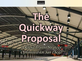
  • 1. THE CENTER FOR ADVANCED URBAN VISIONING The Quickway Proposal A Rapid Transit Strategy Optimized for San Diego OCTOBER 2018
  • 2. THE CENTER FOR ADVANCED URBAN VISIONING Why are we planning to invest over $20 billion in transit projects? Shape Regional Growth Reduce Pressure on Parking, Roads
  • 3. THE CENTER FOR ADVANCED URBAN VISIONING Shape Regional Growth Reduce Pressure on Parking, Roads For transit to shape future growth, it must first effectively serve the city as it is today.
  • 4. THE CENTER FOR ADVANCED URBAN VISIONING Shape Regional Growth Reduce Pressure on Parking, Roads What Matters Most? 1. Travel time (door to door) 2. Wait time 3. Station design 4. How close to destinations?
  • 5. THE CENTER FOR ADVANCED URBAN VISIONING San Diego’s adopted regional transit plan looks extensive. What’s the problem?
  • 6. THE CENTER FOR ADVANCED URBAN VISIONING Plans are expressions of strategies. What are our current strategies, and how are they working?
  • 7. THE CENTER FOR ADVANCED URBAN VISIONING 1. Build out a light rail spine. 2. Run “Rapid Buses” on major arterials. 3. Add Express buses to the airport. 4. Build HOV and managed lanes. Current Transit Strategy
  • 8. THE CENTER FOR ADVANCED URBAN VISIONING How well is this working?
  • 9. THE CENTER FOR ADVANCED URBAN VISIONING 1. The Trolley is not attracting large numbers of people from their cars. 100% 80% 60% 40% 20% 0% 1995 2003 % of Trolley Riders Who “Had an Auto Available” for Their Trip 2009 Source: SANDAG Why? 1. Trolley trips still take too long. 2. Stations are often not conveniently located. 3. The overall customer experience is lacking. 2015* *Beginning with 2015, SANDAG changed the question; results are interpolated.
  • 10. THE CENTER FOR ADVANCED URBAN VISIONING 2. The Trolley is not attracting the middle-income market. Source: SANDAG, “Results of the 2009 Onboard Transit Passenger Survey for the San Diego Region,” (February, 2011). The San Diego Trolley (light rail) attracts the identical low- income market of the MTS Bus. 0% 10% 20% 30% 40% 50% Below $15k $15k - <$25k $25k - <$50k $50k - <$75k $75k - <$100k $100k and Up MTS Bus Trolley Commuter Rail Freeway Bus Household Income
  • 11. THE CENTER FOR ADVANCED URBAN VISIONING 3. Too many land uses are not well-served. ¼ Mile Radius around Trolley Station Office Employment Mission Valley Though Mission Valley is one of the region’s largest office markets, the vast majority of office jobs are distant from a Trolley station.
  • 12. THE CENTER FOR ADVANCED URBAN VISIONING 4. No mode of commuting has decreased more than carpooling. -4.3% -0.7% -1/3 -1/5
  • 13. THE CENTER FOR ADVANCED URBAN VISIONING Transit = FAIL! When the freeway is blocked: 5. The system lacks resilience & back-up.
  • 14. THE CENTER FOR ADVANCED URBAN VISIONING 1. Get closer to more people, especially in denser, walkable, mixed use neighborhoods. 2. Get a lot closer to a lot more jobs. 3. Make transit as fast and direct as possible to minimize travel times. 4. Minimize wait times. 5. Design stations to provide better protection from the elements (sun, wind, and rain), moving vehicles, and other people. How to Maximize Ridership
  • 15. THE CENTER FOR ADVANCED URBAN VISIONING The Quickway Strategy 1. Market Research. Understand what attracts transit riders. 2. Optimized System. Design your “ideal” network to maximize perceived consumer value. 3. Replicate that System. Using electric Rapid Buses, begin implementing that network. 4. Build Infrastructure. Direct capital $ to create a flexible infrastructure that cuts travel time or otherwise creates a sustainable competitive advantage. 5. Upgrade. Upgrade modes over time as feasible.
  • 16. THE CENTER FOR ADVANCED URBAN VISIONING San Diego Quickway Proposal© 2015 by Alan Hoffman 22 So we like stations that feel like real stations, with live information announcing arrivals, full overhead protection from sun and rain, and sliding glass doors that match up to the doors on the transit vehicle. Regardless of mode—rail or bus—you should have the same consistent experience. Mode shouldn’t matter. 1 2 3 4 Vehicledeparts San Diego Quickway Proposal© 2015 by Alan Hoffman 21 So we like stations that feel like real stations, with live information announcing arrivals, full overhead protection from sun and rain, and sliding glass doors that match up to the doors on the transit vehicle. Regardless of mode—rail or bus—you should have the same consistent experience. Mode shouldn’t matter. 1 2 3 4 Boardvehicle San Diego Quickway Proposal© 2015 by Alan Hoffman 19 So we like stations that feel like real stations, with live information announcing arrivals, full overhead protection from sun and rain, and sliding glass doors that match up to the doors on the transit vehicle. Regardless of mode—rail or bus—you should have the same consistent experience. Mode shouldn’t matter. 1 2 3 4 Waitingfor vehicle San Diego Quickway Proposal© 2015 by Alan Hoffman 20 So we like stations that feel like real stations, with live information announcing arrivals, full overhead protection from sun and rain, and sliding glass doors that match up to the doors on the transit vehicle. Regardless of mode—rail or bus—you should have the same consistent experience. Mode shouldn’t matter. 1 2 3 4 Vehiclearrives
  • 17. THE CENTER FOR ADVANCED URBAN VISIONING San Diego: Household Density Households per Acre The Trolley largely avoids areas of high population density. And though Downtown has developed a lot of new housing, Trolley boardings in Downtown haven’t reflected that growth.
  • 18. THE CENTER FOR ADVANCED URBAN VISIONING Quickways: A Flexible Infrastructure While most people think of rail—light rail or metro—when thinking Rapid Transit, there are real advantages to creating a grade-separated infrastructure for rubber-tired vehicles. Transitways such as Quickways can support a larger range of routes than rail, handle a far steeper grade, and can also be used by emergency services vehicles such as ambulances.
  • 19. THE CENTER FOR ADVANCED URBAN VISIONINGBrisbane: The Quickway Model “Brisbane is now at the leading edge in urban mass transit… the new busway… will attract international attention for the level of quality and customer focus that [has been] incorporated.” — Hans Rat, Secretary General International Public Transport Association (IUTP)
  • 20. THE CENTER FOR ADVANCED URBAN VISIONING This two-lane Quickway in Australia moves more people in the peak hour than the busiest light rail line in all of North America—and over seven times as many riders as the busiest section of the San Diego Trolley!
  • 21. THE CENTER FOR ADVANCED URBAN VISIONING
  • 22. THE CENTER FOR ADVANCED URBAN VISIONING The use of grade separations allows this Quickway to locate stations in optimal locations, like this one literally built into a major hospital.
  • 23. THE CENTER FOR ADVANCED URBAN VISIONING 140% 120% 160% 100% 80% 60% 40% 20% 2003 2009 + 60% Brisbane: Ridership Growth 2008 Ridership: Rail: 60 million Busway: 50 million 2010 Ridership: Busway: 72 million Brisbane increased transit ridership by 60% in six years on the basis of 13 miles of grade-separated Quickways, while ridership on their rail network remained flat.
  • 24. THE CENTER FOR ADVANCED URBAN VISIONING Long-Term Evolution Quickway segment & station Quickway segment & station
  • 25. THE CENTER FOR ADVANCED URBAN VISIONING Uncongested roadwayQuickway segment & station Quickway segment & station Long-Term Evolution
  • 26. THE CENTER FOR ADVANCED URBAN VISIONING Quickway segment & station Quickway segment & station Long-Term Evolution
  • 27. THE CENTER FOR ADVANCED URBAN VISIONING Quickway segment & station Quickway segment & station Long-Term Evolution
  • 28. THE CENTER FOR ADVANCED URBAN VISIONING The first generation of autonomous transit vehicles is already commercially available.
  • 29. THE CENTER FOR ADVANCED URBAN VISIONING What About Stations?
  • 30. THE CENTER FOR ADVANCED URBAN VISIONING Cities all over the world have created attractive Rapid Transit systems using buses. This station in Venezuela is an example.
  • 31. THE CENTER FOR ADVANCED URBAN VISIONING This station mock-up is from Cape Town, South Africa.
  • 32. THE CENTER FOR ADVANCED URBAN VISIONING This station is from the Rea Vaya BRT network in Johannesburg, South Africa
  • 33. THE CENTER FOR ADVANCED URBAN VISIONING What a great way to arrive at a destination!
  • 34. THE CENTER FOR ADVANCED URBAN VISIONING The global standard is to use sliding doors or gates to protect children from moving vehicles.
  • 35. THE CENTER FOR ADVANCED URBAN VISIONING Phase I: The San Diego Connected INTEGRATED GREEN INFRASTRUCTURE Demonstration Project What does a Quickway system look like for San Diego? The first three phases have been identified.
  • 36. THE CENTER FOR ADVANCED URBAN VISIONING UNDERGROUND SEGMENT MISSION VALLEY QUICKWAY SURFACE/ELEVATED SEGMENT UPTOWN QUICKWAY UNDERGROUND SEGMENT FreewayDeck ParkingGarage 6th AveTransit Corridor AutoUnderpass BicycleSpiral Canyon Restoration& Landscapingwith BikewayBakedIn Joint Quickway/ GreenwayStructure THE CENTER FOR ADVANCED URBAN VISIONING © 2017 by The Center for Advanced Urban Visioning. All rights reserved. HistoricStreetcar “Streetcar” Routes, upgradabletorail Rapid Bus Quickway SuperStation Trolley Streetcar STATION TYPES: Quickway Bus Lanes (Surface) Rapid Bus Route Bicycle Greenway Road Tunnel Streetcar Trackless Streetcar INFRASTRUCTURE: Integrated Green Infrastructure 30th Street Streetcar Corridor NORTH PARK SuperStation HILLCREST CENTER SuperStation WASHINGTON STREET SuperStation FASHION VALLEY SuperStation San Diego Connected is a $2.2 billion first phase (same budget as the Mid-Coast Light Rail Project). It is designed to slash travel time to/from the new light rail line, as well as make transit competitive in the core areas of the region. In addition to Quickways, it includes world- class bicycle facilities, streetcars, and canyon restoration.
  • 37. THE CENTER FOR ADVANCED URBAN VISIONING UNDERGROUND SEGMENT SURFACE/ELEVATED SEGMENT UNDERGROUND SEGMENT Quickways Grade-Separated Transit Integrated Green Infrastructure HILLCREST CENTER FASHION VALLEY Mercy NORTH PARK Uptown District 28th Esteban Bahena Albatross UCSD Hillcrest Hotel Circle Frazee Friars Mission Ctr This phase I project includes the first 5.5 miles of Quickway in three segments, of which 2.5 miles of which is underground, 1.5 miles elevated, and the rest surface. Together, these Quickways serve 4 SuperStations, 7 Quickway stations, and 3 “satellite” station entrances.
  • 38. THE CENTER FOR ADVANCED URBAN VISIONING HILLCREST CENTER MERCY ALBATROSS Tunnel Surface Elevated Auto Tunnel Trolley Shuttle Lane Bicycle Greenway LEGEND Hillcrest is served with a mostly underground infrastructure that is integrated with bicycle and road improvements.
  • 39. THE CENTER FOR ADVANCED URBAN VISIONING FIVE POINTS WASHINGTON ST RENTAL CAR Tunnel Surface Elevated Bus Lanes Trolley Existing Transitway Rapid Bus Routes LEGEND Middletown (Five Points) sees an upgrade of the Washington Street station to a SuperStation, the primary link to the Mid-Coast Trolley line.
  • 40. THE CENTER FOR ADVANCED URBAN VISIONING NORTH PARK PSA WABASH NORTH PARK SUPERSTATION Future Streetcar Tunnel on 30th St Bilevel Station Two Surface Stations ~4 Minute Travel Time Savings at Rush Hour Tunnel Busway Elevated Bus Lanes Trolley Existing Busway Rapid Bus Routes LEGEND
  • 41. THE CENTER FOR ADVANCED URBAN VISIONING UNDERGROUND SEGMENT SURFACE/ELEVATED SEGMENT UNDERGROUND SEGMENT Quickways Grade-Separated Transit Integrated Green Infrastructure HILLCREST CENTER FASHION VALLEY Mercy NORTH PARK Uptown District 28th Esteban Bahena Albatross UCSD Hillcrest Hotel Circle Frazee Friars Mission Ctr Integrated Green Infrastructure PILOT PROJECT Rapid Bus Routes A large set of electric Rapid Bus routes use all or part of the new Quickway infrastructure, producing real time savings.
  • 42. THE CENTER FOR ADVANCED URBAN VISIONING 58th College& University Aragon Yale Parks LaMesa Springs Kroc Ctr LaMesa CivicCtr Acacia LaMesa Blvd LaMesa Village College Euclid BankersHill CORTEZPLAZA/ DOWNTOWN GATEWAY Old Globe/ Museum of Man Plazade Panama BALBOA PARK 5thAVE Gaslamp Central GASLAMP/ CONVENTIONCTR Petco Park PSA Wabash Cherokee Zoo / Balboa Park Naval Hospital Mission Hills ALBATROSS WASHINGTON ST Comstock Ulric Tait E Genesee Mary Birch Sharp Memorial Children’s Juvenile Court Mesa College Allied Health Kearny HS Arizona UPTOWN DISTRICT Texas 30th & El Cajon 35th Monroe University Hts Trolley Barn Pk Oregon 32nd Normal Hts 35th EMtn View NORTH PARK CITY HEIGHTS BOULEVARD Laurel / BalboaPark Quince Upas Winona 54th College Van Dyke City Hts Village RosaParks Manzanita Olive Old Town Morena/ LindaVista Hazard Center Mission Valley Center Rio Vista Fenton Parkway Qualcomm Stadium Mission San Diego Mission Valley Rd Via Alta Civita Rio Bonito River Run HILLCREST CENTER FASHION VALLEY Polk Kensington Aldine Collwood Aztec I-15 & Adams SANTAFE DEPOT SDSU Library Tony Gwynn Fault Line GSt Police HQ 16th 22nd 25th 28th Beech Cedar Grape Juniper Redwood Landis MyrtlePershing Hawthorne County Park CruiseShip Terminal Harbor Island Terminal 1 Terminal 2 SANDIEGO INTERNATIONAL AIRPORT MERCY UCSD HILLCREST HOTEL CIRCLE FRAZEE Park & Howard Park & University Mission Center Rd Avenida del Rio Siesta Camino del Rio N Centerside ESTEBAN BAHENA I-15 UNIVERSITY AVE ADAMS AVE Hilton Sheraton Scottish Rite Camino del Rio S 805 Mission City Scheidler Kearny Mesa/ I-15 to Escondido 7thHorton Plaza Justice Grantville EL CAJON BLVD COLLEGEAVE CAMINO DEL RIO SOUTH CAMINO DE LA REINA CAMINO DEL RIO NORTH RIO SAN DIEGO DR CIVITA BLVD 30THST PARKBLVD P BICYCLE GREENWAY THE CENTER FOR ADVANCED URBAN VISIONING © 2017 by The Center for Advanced Urban Visioning. All rights reserved. ESt CITY COLLEGE Antique Row Rental Car Express to Airport West of Van Dyke Station, stops only at SuperStationsFIVE POINTS Kearny Mesa National City and ChulaVista Friars Mission Ctr La Mesa Village This map depicts the electric Rapid Bus (and street- car) routes that would use the new Quickways (light yellow background). Significant travel time savings and improved stations together make the network far more attractive and useful to potential riders. Connections to the Airport, UTC/UCSD, Downtown, and Mission Valley are especially improved.
  • 43. THE CENTER FOR ADVANCED URBAN VISIONING CORTEZPLAZA/ DOWNTOWN GATEWAY 5thAVE HILLCREST CENTER SANTAFE DEPOT P Terminal 1 Terminal 2 SANDIEGO INTERNATIONAL AIRPORT 58th College& University Aragon Yale Parks LaMesa Springs Kroc Ctr LaMesa CivicCtr Acacia LaMesa Blvd LaMesa VillageEuclid City Hts Village Van DykeNORTH PARK MIRAMARCOLLEGE Mira Mesa / ScrippsRanch SABRESPRINGS/ PEÑASQUITOS RANCHOBERNARDO DELLAGO Westfield North County ESCONDIDOTRANSITCTR/ SPRINTER 8thSTREET PLAZABONITA HSTREET Downtown National City St. Matthew’s 4th & Highland Division Delta Plaza& Highland 18th & Highland 24th & Highland 30th & Highland Brisbane D& 4th Rindone/ CivicCtr Downtown ChulaVista Sweetwater Cypress Broadway & H ChulaVistaCtr / Scripps County South Justice Horton Plaza Laurel / BalboaPk CITY HTS BOULEVARD WASHINGTON STREET FASHION VALLEY Kearny Mesa Harbor Island Rental Car In addition to new electric Rapid Bus routes, new MetroXpress routes connects the I-15 corridor, Kearny Mesa, La Mesa/East County, and the South Bay with destinations in the core zone, including the airport.
  • 44. THE CENTER FOR ADVANCED URBAN VISIONING Upon completion of the first three phases of the Quickway Proposal, the proposed MetroXpress route connecting La Mesa with Mid-City, North Park, Hillcrest, the Mid-Coast Trolley, and the Airport will feature extensive grade separation, dramatically slashing travel time.
  • 45. THE CENTER FOR ADVANCED URBAN VISIONING Rapid Bus Station Quickway Station SuperStation Connect to Trolley Quickway Bus Lanes (Surface) Rapid Bus Route Bicycle Greenway Road Tunnel INFRASTRUCTURE: STATION TYPES: CONNECT TO MID-COAST The existing Rapid Bus route from Escondido to Downtown could take advantage of the new Quickways to serve destinations in Mission Valley and Hillcrest, all while saving travel time.
  • 46. THE CENTER FOR ADVANCED URBAN VISIONING BicycleCenter THE CENTER FOR ADVANCED URBAN VISIONING © 2017 by The Center for Advanced Urban Visioning. All rights reserved. Integrated Green Infrastructure Greenways Landscaped Bikeways with Gentle Grades and Minimal Auto/Pedestrian ConflictsA proposed network of bicycle greenways, built to global standards (maximum sustained grade of 3%, 7.5’ lanes, minimal conflict points), would make bicycling a far safer and easier alternative for many thousands of people.
  • 47. THE CENTER FOR ADVANCED URBAN VISIONING THE CENTER FOR ADVANCED URBAN VISIONING © 2017 by The Center for Advanced Urban Visioning. All rights reserved. Integrated Green Infrastructure PILOT PROJECT To Airport To Kensington North Park 30th Street Streetcar NetworkThe North Park Street Car Network connects North Park’s 30th Street corridor with University Heights, Normal Heights, Kensington, South Park, Golden Hill, the East Village, Downtown, the Waterfront, and the Airport. It would use a combination of rubber-tired and steel-wheeled streetcars.
  • 48. THE CENTER FOR ADVANCED URBAN VISIONING Bicycle Greenway Cortez Plaza Transit & Streetcar Lanes Rapid Bus and Streetcar Routes Transit Station Transit Lanes The “Mend the Bend” effort to cap I-5 with new parklands is integrated into the Phase I projects. A new transit station, public plaza, parking structure, and civic buildings combine to create an active and useful new addition to Downtown.
  • 49. THE CENTER FOR ADVANCED URBAN VISIONING GASLAMP CENTRAL E STREET Horton Plaza / Balboa Theatre 5TH AVE TROLLEY ASH ST GASLAMP / CONVENTION CTR Petco Park Broadway Transit Corridor 6th Avenue Transit Spine CORTEZ PLAZA / DOWNTOWN GATEWAY 6th Avenue Downtown, like 30th Street in North Park, is budgeted for a complete rebuild to accommodate new transit lanes, enhanced sidewalks, new landscaping, new transit stations, and new parking facilities.
  • 50. THE CENTER FOR ADVANCED URBAN VISIONING Phase II: The Mid-Coast Supportive Projects The Phase II projects link the new Mid-Coast Trolley line with communities to its west.
  • 51. THE CENTER FOR ADVANCED URBAN VISIONING A combination of Quickway infrastructure, transit lanes, and other treatments slash transit travel times to the Trolley from OB, Mission Beach, and Pacific Beach, as well as better connecting these communities with areas served by Phase I projects. New rapid routes are depicted by dashed lines.
  • 52. THE CENTER FOR ADVANCED URBAN VISIONING Core Transitways Bus Lanes Trolley Rapid Bus Routes LEGEND SuperStation Station Rapid Bus Station Trolley Station This map depicts rapid transit routes and infrastruc- ture in the core urban zones following the completion of Phases I and II.
  • 53. THE CENTER FOR ADVANCED URBAN VISIONING Phase III: The Sails to Trails Corridor The “Sails to Trails” corridor is San Diego’s historic growth corridor, extending from Downtown to Mission Trails via El Cajon Boulevard. Once Phases I and II are completed, this corridor is slated for massive improvements.
  • 54. THE CENTER FOR ADVANCED URBAN VISIONINGAfter Phases I and II are completed, this is what North Park and Western Mid-City look like: some infrastructure, but mostly opportunity.
  • 55. THE CENTER FOR ADVANCED URBAN VISIONINGTHE CENTER FOR ADVANCED URBAN VISIONING THE CENTER FOR ADVANCED URBAN VISIONING THE CENTER FOR ADVANCED URBAN VISIONING 1 2 3 4 A series of projects, including road improvements, gradually extends the benefits of grade separation along major sections of El Cajon Boulevard and University Avenue.
  • 56. THE CENTER FOR ADVANCED URBAN VISIONING Once completed, grade separations (in black) will produce transit travel times faster than driving for an important set of transit links.
  • 57. THE CENTER FOR ADVANCED URBAN VISIONING little transit infrastructureserves these communities. The “Rapid Bus” Route 215 connects SDSU with downtown via College Ave, El Cajon Blvd and Park Blvd, though peak-period travel speeds make this bus only marginally principal east/west arterials from getting onto the I-15 busway, mandating transfers for anyone heading north or south. There are no current rapid or semi-rapid connections into Mission Valley. On the surface, with some traffic diverted and some replaced with transit trips, a linear park can be developed running down the middle of El Cajon Boulevard, similar to this example from Copenhagen.
  • 58. THE CENTER FOR ADVANCED URBAN VISIONING TBD TBD TBD A “Strategic Investment Zone” extending perhaps 600’ on either side of the proposed transit and park improvements (which include a major new “Great Park of North Park” and new Mid City Park), can be defined by a “Form-Based Code” developed in consultation with the community to organize and concentrate new development around transit, bicycling, and parks.
  • 59. THE CENTER FOR ADVANCED URBAN VISIONING Following completion of the first three phases of Quickway development, the core of the region will feature significant transit infrastructure capable of slashing travel times, improving the customer experience, and making transit competitive for a large set of trips that today require a car. Future extensions would feed off of and into this base network.
  • 60. THE CENTER FOR ADVANCED URBAN VISIONING This map depicts the draft infrastructure of the Quickway Proposal for Central and South County.
  • 61. THE CENTER FOR ADVANCED URBAN VISIONING This map depicts the draft infrastructure of the Quickway Proposal for North County.
  • 62. THE CENTER FOR ADVANCED URBAN VISIONING At build-out, the Quickway Proposal would support an extensive network of Mainline (all-stops) and MetroXpress routes that reach into much of the region and that makes transit fully competitive with driving for many trips.
  • 63. THE CENTER FOR ADVANCED URBAN VISIONING Outcomes “Outcomes” means “results.” How does the Quickway Proposal compare as a plan with San Diego’s current adopted plan?
  • 64. THE CENTER FOR ADVANCED URBAN VISIONING SanDiegoQuickwayProposal –AssemblyDistrict 77© 2015 byAlanHoffman 150 EstimatedCapital Costs ($Billions) $- $5 $10 $15 $20 Quickway Proposal Existing2050 Plan $14 $20 $Billions Note: Figures are from 2008 and will need to be updated. Estimated Capital Costs (2008) ($ Billions) The first complete draft of the Quickway Proposal was priced at $14 billion, over 25% cheaper to build than the current plan. Costs today have risen, but they have risen for both plans.
  • 65. THE CENTER FOR ADVANCED URBAN VISIONING SanDiegoQuickwayProposal –AssemblyDistrict 77© 2015 byAlanHoffman 151 ProjectedOperatingSubsidiesthrough2050($ Billions) $11 $14 $19 $- $5 $10 $15 $20 Quickway Proposal: LOW Quickway Proposal: HIGH Current 2050 Plan $Billions Projected Operating Subsidies through 2050 ($ Billions) The Quickway Proposal is far more efficient to operate than our current plans.
  • 66. THE CENTER FOR ADVANCED URBAN VISIONING What About Ridership? Base Projections Using 2006 population and trip patterns: > 240% Adjusting for 2050 projected population and trip patterns: ~ 400-500% ? …But even our model did not capture or measure some of the things we’ve done to maximize ridership.
  • 67. THE CENTER FOR ADVANCED URBAN VISIONING What About Ridership? Precedents An independent analysis by URS (now part of AECom) of a similar strategy developed for the Metro Atlanta Region found that, compared to their adopted Transit Plan, the market-focused plan: Doubled Ridership per Invested Dollar and also: Significantly reduced automotive congestion.
  • 68. THE CENTER FOR ADVANCED URBAN VISIONING Comparative Performance This final series of maps compares the Quickway Proposal (and, in some cases, just the Phase I projects!) with the current transit plan for area coverage (areas within ¼ mile of a station) and travel time.
  • 69. THE CENTER FOR ADVANCED URBAN VISIONING UPTOWN/NORTH PARK/CITY HEIGHTS RTP 2050 Rapid & Semi-Rapid Transit Area within ¼ mile radius of: Rapid Transit station Semi-Rapid station within 3 stops of becoming Rapid Transit Semi-Rapid Transit Station Streetcar stop At build-out, the 2050 Regional Transportation Plan (RTP) calls for light rail along El Cajon Boulevard, rapid buses along University Avenue, Adams Avenue/Park Boulevard, and Bachman Drive, and streetcars on 30th Street and making a Hillcrest loop with downtown via Balboa Park. Since streetcar is generally a slow mode, it is not counted as rapid or even semi-rapid transit. While most residents of these communities will have access to at least semi-rapid transit, relatively few will have access to true Rapid Transit, and for those traveling to places like Mission Valley or the beach communities, travel times will still be excessive. AC2 LIGHT RAIL SURFACE BUSWAY STREETCAR RAPID BUS
  • 70. THE CENTER FOR ADVANCED URBAN VISIONING UPTOWN/NORTH PARK/CITY HEIGHTS Quickway 2025 Rapid & Semi-Rapid Transit Area within ¼ mile radius of: Rapid Transit station Semi-Rapid station within 3 stops of becoming Rapid Transit Semi-Rapid Transit Station Streetcar stop The first phase of the Quickway Proposal anticipates the construction of transit tunnels and other right of way serving the heart of North Park and connecting the center of Hillcrest with Mission Valley (Fashion Valley). These infrastructure pieces make several Rapid Bus lines feasible, due to the time savings and enhanced customer facilities. True Rapid Transit infrastructure and stations now serve the major trip attractors (the two key hospitals as well as the centers of both North Park and Hillcrest). Connections to the Trolley are vastly improved, as well as to much of Mission Valley. The vast majority of residents have access to at least semi-rapid transit. AC3 TUNNEL SURFACE BUSWAY ELEVATED
  • 71. THE CENTER FOR ADVANCED URBAN VISIONING UPTOWN/NORTH PARK/CITY HEIGHTS Quickway 2050 Rapid & Semi-Rapid Transit Area within ¼ mile radius of: Rapid Transit station Semi-Rapid station within 3 stops of becoming Rapid Transit Semi-Rapid Transit Station Streetcar stop In the Quickway Proposal, the majority of the residents of these densely populated communities now enjoy access to true Rapid Transit with routes branching to many key destinations throughout the region. Movement within these communities is also facilitated. A prime innovation in this network is the use of automated, self-guiding shuttles to extend the reach of many Rapid Transit stations with super-high frequency connections; the design goal is to treat these as “horizontal elevators” leading directly into stations. Designed effectively, these are a very low-cost means of significantly improving the effectiveness and attractiveness of Rapid Transit services to residents and visitors alike. AC4
  • 72. THE CENTER FOR ADVANCED URBAN VISIONING CITY OF SAN DIEGO DISTRICT 7 / KEARNY MESA / LINDA VISTA / CLAIREMONT RTP 2050 Rapid & Semi-Rapid Transit Area within ¼ mile radius of: Rapid Transit station Semi-Rapid station within 3 stops of becoming Rapid Transit Semi-Rapid Transit Station Streetcar stop This area is subject to significant new Rapid Transit and semi-rapid transit in the RTP. Three Trolley lines are anticipated to converge in Kearny Mesa. Still, Mission Valley receives practically no improvements, and relatively few new Rapid Transit stations serve residents. While service is improved relative to existing services, it still falls far short of being useful for most residents. AC6
  • 73. THE CENTER FOR ADVANCED URBAN VISIONING CITY OF SAN DIEGO DISTRICT 7 / KEARNY MESA / LINDA VISTA / CLAIREMONT Quickway 2050 Rapid & Semi-Rapid Transit Area within ¼ mile radius of: Rapid Transit station Semi-Rapid station within 3 stops of becoming Rapid Transit Semi-Rapid Transit Station Streetcar stop The full Quickway Proposal for this zone shows extensive coverage; virtually all of Mission Valley and Kearny Mesa enjoy access to Rapid Transit, as well as enhanced portions of Clairemont and Tierrasanta, while other communities enjoy more extensive access to semi-rapid transit that is well-integrated with the Rapid Transit network. Large numbers of residents have access to this system. AC8
  • 74. THE CENTER FOR ADVANCED URBAN VISIONING NATIONAL CITY & SOUTHEAST COMMUNITIES RTP 2050 Rapid & Semi-Rapid Transit Area within ¼ mile radius of: Rapid Transit station Semi-Rapid station within 3 stops of becoming Rapid Transit Semi-Rapid Transit Station Streetcar stop A new light rail line, the Purple Line, is proposed by SANDAG to run through the heart of the South Bay cities, through Mid- City San Diego, and into Kearny Mesa. Access to Rapid or Semi-Rapid Transit still remains somewhat limited, and the Purple Line will not make travel to points west easy or quick. AC15
  • 75. THE CENTER FOR ADVANCED URBAN VISIONING NATIONAL CITY & SOUTHEAST COMMUNITIES Quickway 2050 Rapid & Semi-Rapid Transit Area within ¼ mile radius of: Rapid Transit station Semi-Rapid station within 3 stops of becoming Rapid Transit Semi-Rapid Transit Station Streetcar stop The Quickway Proposal anticipates a more flexible set of infrastructure investments that about double effective access to Rapid or semi-rapid transit. Travel times to many key destinations are significantly improved in the Quickway Proposal, easing access to far more of the region’s job opportunities. AC16
  • 76. THE CENTER FOR ADVANCED URBAN VISIONING NATIONAL CITY & SOUTHEAST COMMUNITIES RTP 2050 Rapid & Semi-Rapid Transit Area within ¼ mile radius of: Rapid Transit station Semi-Rapid station within 3 stops of becoming Rapid Transit Semi-Rapid Transit Station Streetcar stop The RTP anticipates a new Trolley line, the Purple Line, traveling through the heart of Chula Vista, and a new Rapid Bus line on the H Street corridor. Though both will be useful additions compared to current services, most residents remain beyond walking access from Rapid or semi-rapid transit. AC18
  • 77. THE CENTER FOR ADVANCED URBAN VISIONING NATIONAL CITY & SOUTHEAST COMMUNITIES Quickway 2050 Rapid & Semi-Rapid Transit Area within ¼ mile radius of: Rapid Transit station Semi-Rapid station within 3 stops of becoming Rapid Transit Semi-Rapid Transit Station Streetcar stop Compared to the RTP, the Quickway Proposal extends access to both Rapid and semi-rapid Transit to a much larger share of Chula Vista’s residents and destinations. Travel times within Chula Vista are improved, as well as access to regional destinations, most of which will be brought much closer to Chula Vista. AC19
  • 78. THE CENTER FOR ADVANCED URBAN VISIONING Base map: “2050 Housing and Employment Densities and Urban Area Transit Strategy Boundary” (SANDAG, San Diego Forward: The Regional Plan, 2016, p. 37). RTP 2050 Stations within of Fashion Valley Matched to 2050 Employment & Housing Densities CENTRAL SAN DIEGO While many of the stations that are within 30 minutes by transit of Fashion Valley in the RTP are surrounded by jobs, they represent only a small portion of the jobs in the central zone. TT7
  • 79. THE CENTER FOR ADVANCED URBAN VISIONING Base map: “2050 Housing and Employment Densities and Urban Area Transit Strategy Boundary” (SANDAG, San Diego Forward: The Regional Plan, 2016, p. 37). Quickway Stations within of Fashion Valley Matched to 2050 Employment & Housing Densities CENTRAL SAN DIEGO The Quickway Proposal brings many more jobs and residences closer to Fashion Valley than the RTP. Similar results may be expected for most locations in the region. Why wouldn’t we pursue a strategy that provides superior connectivity? TT8
  • 80. THE CENTER FOR ADVANCED URBAN VISIONING PLEASE NOTE: THESE MAPS ARE APPROXIMATE DEPICTIONS. 2050 RTP PLEASE NOTE: THESE MAPS ARE APPROXIMATE DEPICTIONS. TRAVEL TIMES CALCULATED FOR WEEKDAY COMMUTE, ARRIVAL BY 8:30 AM. TT9 MISSION VALLEY RTP 2050 Stations within 10 Minutes of Fashion Valley The only real improvements planned for Mission Valley in the RTP are Rapid Bus lines to Linda Vista and Hillcrest. Otherwise, most of Mission Valley, including most office employment and most residents, are not directly served. Travel times to Fashion Valley during the AM commute were calculated for both the RTP and the Quickway Proposal. Fashion Valley was chosen as a destination due to its centrality in the region and its importance as a transfer center.
  • 81. THE CENTER FOR ADVANCED URBAN VISIONING 2050 RTP PLEASE NOTE: THESE MAPS ARE APPROXIMATE DEPICTIONS. TRAVEL TIMES CALCULATED FOR WEEKDAY COMMUTE, ARRIVAL BY 8:30 AM. TT11 MISSION VALLEY RTP 2050 Stations within of Fashion Valley Very few additional stations are brought within 20 minutes of Fashion Valley compared to 10 minutes in the RTP 2050 Transit Plan. Most of the office jobs and residences in Mission Valley are not within ¼ mile of Rapid or semi-rapid transit. Travel times to Fashion Valley during the AM commute were calculated for both the RTP and the Quickway Proposal. Fashion Valley was chosen as a destination due to its centrality in the region and its importance as a transfer center.
  • 82. THE CENTER FOR ADVANCED URBAN VISIONING Quickway Proposal PLEASE NOTE: THESE MAPS ARE APPROXIMATE DEPICTIONS. TRAVEL TIMES CALCULATED FOR WEEKDAY COMMUTE, ARRIVAL BY 8:30 AM. 10MINUTES TT10 MISSION VALLEY Quickway 2050 Stations within 10 Minutes of Fashion Valley The Quickway Proposal specifies infrastructure to speed transit services into, out of, and through Mission Valley. Large areas of both Mission Valley and surrounding communities (North Park, Hillcrest, and Linda Vista) and brought wihin 10 minutes of Fashion Valley. Travel times to Fashion Valley during the AM commute were calculated for both the RTP and the Quickway Proposal. Fashion Valley was chosen as a destination due to its centrality in the region and its importance as a transfer center.
  • 83. THE CENTER FOR ADVANCED URBAN VISIONING Quickway Proposal PLEASE NOTE: THESE MAPS ARE APPROXIMATE DEPICTIONS. TRAVEL TIMES CALCULATED FOR WEEKDAY COMMUTE, ARRIVAL BY 8:30 AM. TT12 MISSION VALLEY Quickway 2050 Stations within of Fashion Valley The vast majority of Mission Valley is within 20 minutes of Fashion Valley in the Quickway Proposal, as well as much of North Park, University Heights, Normal Heights, Linda Vista, and other nearby communities. The combination of faster travel times and much broader area coverage make the Quickway network more useful to more people. Travel times to Fashion Valley during the AM commute were calculated for both the RTP and the Quickway Proposal. Fashion Valley was chosen as a destination due to its centrality in the region and its importance as a transfer center. 20MINUTES
  • 84. THE CENTER FOR ADVANCED URBAN VISIONING Kearny Mesa QUICKWAY PROPOSAL From no part of Kearny Mesa does rapid or semi-rapid transit get you to Fashion Valley in 10 minutes or less during the AM commute. The Sharp Hospital District, much of Convoy, and even Clairemont Mesa Boulevard are within 10 minutes of Fashion Valley. SANDAG RTP 2050 PLAN Areas within 10MINUTES by Rapid or Semi- Rapid Transit of the Fashion Valley Transit Station PLEASE NOTE: THESE MAPS ARE APPROXIMATE DEPICTIONS. TRAVEL TIMES CALCULATED FOR WEEKDAY COMMUTE, ARRIVAL BY 8:30 AM. KEARNY MESA Station Areas within 10 minutes of Fashion Valley: SANDAG 2050 RTP Plan vs the Quickway Proposal TT14
  • 85. THE CENTER FOR ADVANCED URBAN VISIONING Most of Kearny Mesa, parts of Clairemont and Serra Mesa, and Mesa College are all within 20 minutes of Fashion Valley. The northern part of the Sharp Hospital District and a busy corner in Kearny Mesa are within 20 minutes of Fashion Valley. Kearny Mesa QUICKWAY PROPOSALSANDAG RTP 2050 PLAN Areas within by Rapid or Semi- Rapid Transit of the Fashion Valley Transit Station PLEASE NOTE: THESE MAPS ARE APPROXIMATE DEPICTIONS. TRAVEL TIMES CALCULATED FOR WEEKDAY COMMUTE, ARRIVAL BY 8:30 AM. KEARNY MESA Station Areas within of Fashion Valley: SANDAG 2050 RTP Plan vs the Quickway Proposal TT15
  • 86. THE CENTER FOR ADVANCED URBAN VISIONING Kearny Mesa QUICKWAY PROPOSAL Some locations in Kearny Mesa are now within a 30 minute rapid or semi- rapid transit trip of Fashion Valley. Most of the rest of Kearny Mesa is now served. SANDAG RTP 2050 PLAN Areas within by Rapid or Semi- Rapid Transit of the Fashion Valley Transit Station PLEASE NOTE: THESE MAPS ARE APPROXIMATE DEPICTIONS. TRAVEL TIMES CALCULATED FOR WEEKDAY COMMUTE, ARRIVAL BY 8:30 AM. KEARNY MESA Station Areas within of Fashion Valley: SANDAG 2050 RTP Plan vs the Quickway Proposal TT16
  • 87. THE CENTER FOR ADVANCED URBAN VISIONING Travel Times NORTH COUNTY 78 6 75 8 22 9 62 29 17 8 49 15 92 13 88 9 28 11 66 17 51 26 74 34 41 27 35 1264 26 Average Travel Times: CURRENT TRANSIT: 56.1Mins. QUICKWAY TRANSIT: 16.7 Mins. Travel time savings in North County average 70%, though in some cases this is because of the lack of current transit options. Even so, many transit times become competitive with driving under the Quickway Proposal. NORTH COUNTY Quickway Proposal Projected Travel Times vs Current Transit Travel TImes TT17 Please note: Travel times calculated in 2014. Ongoing improvements to both the current network and the Quickway Proposal may have shifted some times (for example, current travel time from the Escondido Transit Center to Sorrento Mesa has been reduced from 62 to 61 minutes).
  • 88. THE CENTER FOR ADVANCED URBAN VISIONING Travel Times (Minutes) 21 8 5 2 19 12 44 10 10 4 21 7 29 11 7 3 12 529 13 3 3 33 5 7 524 14 46 9 20 12 32 14 15 14 17 17 18 5 19 4 14 8 26 12 12 8 22 9 21 7 11 4 12 4 25 15 54 20 38 13 QUICKWAY TRANSIT: 9.1 Mins. CURRENT TRANSIT: 22.2Mins. 18 5 39 18 22 9 CENTRAL Average Travel Times: CENTRAL & EAST COUNTY Quickway Proposal Projected Travel Times vs Current Transit Travel TImes TT18
  • 89. THE CENTER FOR ADVANCED URBAN VISIONING Travel Times SOUTH BAY 9 7 7 8 12 20 6 2 6 12 7 15 7 20 13 16 55 7 18 22 35 19 41 45 29 44 66 12 Average Travel Times: CURRENT TRANSIT: 30.1Mins. QUICKWAY TRANSIT: 9.9 Mins. BEST DRIVING TIME: 9.1 Mins. SOUTH COUNTY Quickway Proposal Projected Travel Times vs Current Transit Travel TImes TT19
  • 90. THE CENTER FOR ADVANCED URBAN VISIONING Ridership Compared to the RTP, the Quickway Proposal is designed to attract higher ridership by creating more value for more people. The QP connects many more people with many more likely destinations more directly in far less time and with a more customer-friendly station-based interface. The QP is designed to attract far more “Transit-Oriented Development” than the RTP by placing transit infrastructure and services precisely in areas with high market demand. Parallel world-class bicycle Greenways further enhance modal shift from cars.
  • 91. THE CENTER FOR ADVANCED URBAN VISIONING Conclusion The combo of higher ridership + more TOD = significant reductions in ghg emissions relative to the auto-centric RTP. Because the benefits of Quickways extend many miles from the actual guideways, more of the region can be connected more effectively in less time for the same level of resources. By maximizing consumer value, the QP can better use value capture mechanisms such as IFDs to help finance the program. Modal shift to bicycling, transit, and walking, is significant. Total capital costs of the QP are likely lower than the RTP, but return on investment is much higher. Any rejection of the QP due to costs is not based on transparent and fair analysis.
  • 92. THE CENTER FOR ADVANCED URBAN VISIONING TO SUPPORT OUR WORK, PLEASE VISIT: www.GoFundMe.com/Quickwaywww.GoFundMe.com/Quickway