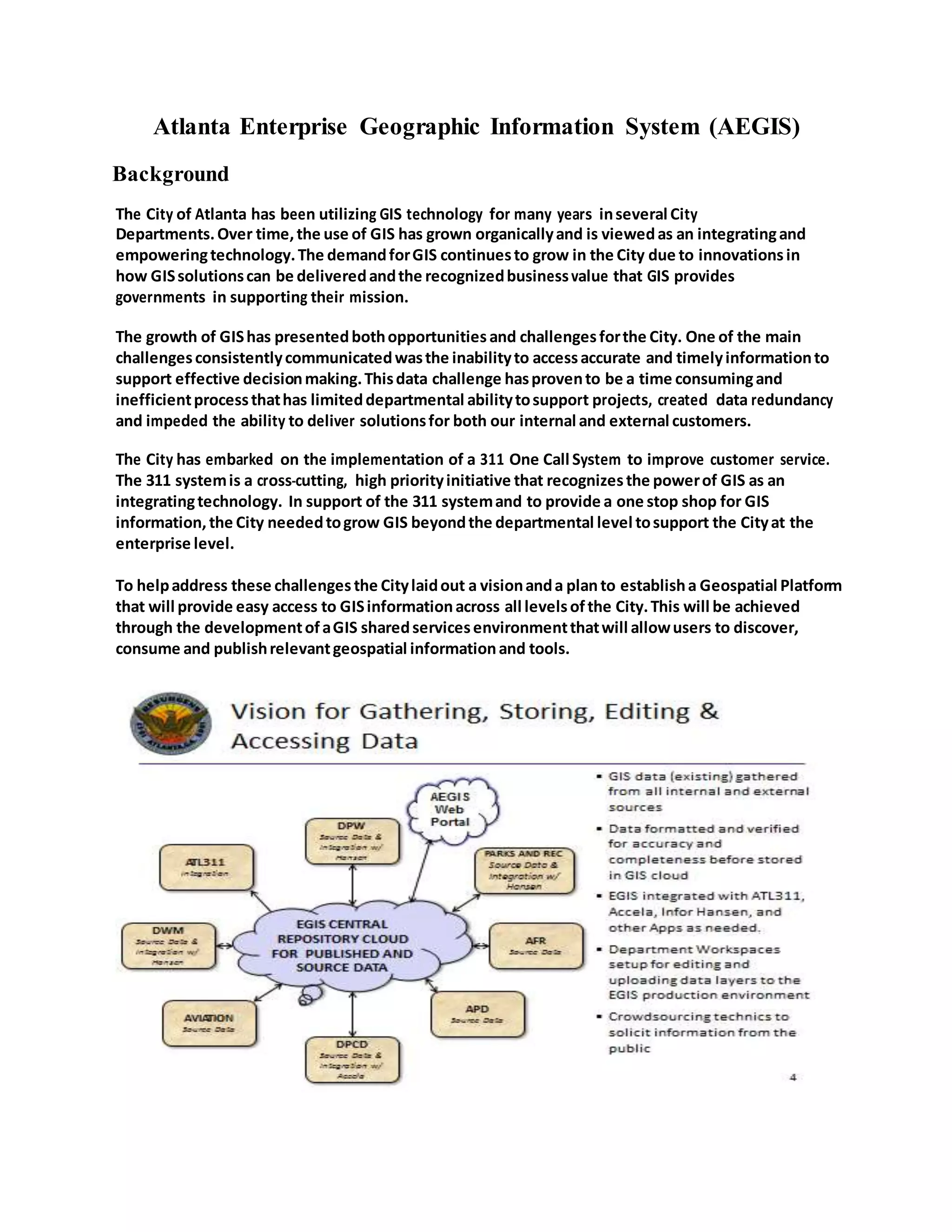
Atlanta Enterprise Geographic Information System (AEGIS)
Background
The City of Atlanta has been utilizing GIS technology for many years inseveral City
Departments.Over time,the use of GIS has grown organicallyand is viewedas an integratingand
empoweringtechnology.The demandforGIS continuesto grow in the City due to innovationsin
how GISsolutionscan be deliveredandthe recognizedbusinessvalue that GIS provides
governments in supporting their mission.
The growth of GIShas presentedbothopportunities and challengesforthe City. One of the main
challengesconsistentlycommunicatedwasthe inabilityto accessaccurate and timelyinformationto
support effective decisionmaking.Thisdata challenge hasprovento be a time consumingand
inefficientprocessthathas limiteddepartmental abilitytosupport projects, created data redundancy
and impeded the ability to deliver solutionsfor both our internal and external customers.
The City has embarked on the implementation of a 311 One Call System to improve customer service.
The 311 systemis a cross-­­cutting, high priorityinitiative that recognizesthe powerof GIS as an
integratingtechnology. In support of the 311 systemand to provide a one stop shop for GIS
information, the City neededtogrow GIS beyondthe departmental level tosupport the Cityat the
enterprise level.
To helpaddress these challenges the Citylaidout a visionanda planto establisha Geospatial Platform
that will provide easy access to GISinformationacross all levelsofthe City.This will be achieved
through the developmentofaGIS sharedservicesenvironmentthatwill allowusers to discover,
consume and publishrelevantgeospatial informationand tools.
The Plan isfocus on three primary areas; Technology, Processesand People.The reasonforfocusing
on these three areas is to establisha sustainable GIS enterprise environmentwiththe appropriate
governance that will support the City’s311 initiative as well as current and future businessneeds.
Benefits
Customer Service
 Provides public with one COAcontact point for GIS information including online
self-service to download select maps
 Establishes central GIS User Helpdesk
 Provides 311 with tools necessary to validate City asset or provision ofservice at
time ofcustomer call
 Provides analytical reporting based on geographic area
Fiscal Stewardship
 Consolidates hardware and infrastructure
 Provides potential for revenue generation
Operational Efficiency
 Allows information to be accessible and shareable across departments
 Provides map printing capabilities for departments without plotters
 Permits use ofGIS as a decision support tool by City management
Inter-governmental Coordination
 Improves coordination ofmapping activities with other public and private agencies.
ProjectScope
The project scope includes the following:
1. Plan and implement a Centralized GIS Program to provide easy access of
information across an enterprise platform.
2. Inventory the City Department’s GIS data layers and attribute information.
3. Develop a Standard in-house web architecture to publish, share, and retrieve data
on all of the City’s geographic assets
4. Develop ATL 311 GIS deployment integration
5. Plan and implement Accela-GIS Program
6. Migrate all departments into EGIS environment
7. Integrate GIS with legacy applications
Status
The implementation ofthe Enterprise GIS began in January 2013. The internal cloud environment
was installed and configured including operating software. GIS applications and database software
was also installed and configured. The cloud environment consistofa redundant production,
test/development and department workspaces.
The integration ofGIS with ATL311 Siebel is in progressand is scheduled to be completed by
December of2013 which represents the end ofthe first phase ofthe EGIS implementation as well as
the Soft launch of the ATL311 one call system. Phase 2 ofEGIS will include the Go-Live ofthe
EGIS Portal and the migration of all City departments to the cloud environment.

Atlanta Enterprise Geographic Information System

  • 1.
    Atlanta Enterprise GeographicInformation System (AEGIS) Background The City of Atlanta has been utilizing GIS technology for many years inseveral City Departments.Over time,the use of GIS has grown organicallyand is viewedas an integratingand empoweringtechnology.The demandforGIS continuesto grow in the City due to innovationsin how GISsolutionscan be deliveredandthe recognizedbusinessvalue that GIS provides governments in supporting their mission. The growth of GIShas presentedbothopportunities and challengesforthe City. One of the main challengesconsistentlycommunicatedwasthe inabilityto accessaccurate and timelyinformationto support effective decisionmaking.Thisdata challenge hasprovento be a time consumingand inefficientprocessthathas limiteddepartmental abilitytosupport projects, created data redundancy and impeded the ability to deliver solutionsfor both our internal and external customers. The City has embarked on the implementation of a 311 One Call System to improve customer service. The 311 systemis a cross-­­cutting, high priorityinitiative that recognizesthe powerof GIS as an integratingtechnology. In support of the 311 systemand to provide a one stop shop for GIS information, the City neededtogrow GIS beyondthe departmental level tosupport the Cityat the enterprise level. To helpaddress these challenges the Citylaidout a visionanda planto establisha Geospatial Platform that will provide easy access to GISinformationacross all levelsofthe City.This will be achieved through the developmentofaGIS sharedservicesenvironmentthatwill allowusers to discover, consume and publishrelevantgeospatial informationand tools.
  • 2.
    The Plan isfocuson three primary areas; Technology, Processesand People.The reasonforfocusing on these three areas is to establisha sustainable GIS enterprise environmentwiththe appropriate governance that will support the City’s311 initiative as well as current and future businessneeds. Benefits Customer Service  Provides public with one COAcontact point for GIS information including online self-service to download select maps  Establishes central GIS User Helpdesk  Provides 311 with tools necessary to validate City asset or provision ofservice at time ofcustomer call  Provides analytical reporting based on geographic area Fiscal Stewardship  Consolidates hardware and infrastructure  Provides potential for revenue generation Operational Efficiency  Allows information to be accessible and shareable across departments  Provides map printing capabilities for departments without plotters  Permits use ofGIS as a decision support tool by City management Inter-governmental Coordination  Improves coordination ofmapping activities with other public and private agencies. ProjectScope The project scope includes the following: 1. Plan and implement a Centralized GIS Program to provide easy access of information across an enterprise platform. 2. Inventory the City Department’s GIS data layers and attribute information. 3. Develop a Standard in-house web architecture to publish, share, and retrieve data on all of the City’s geographic assets 4. Develop ATL 311 GIS deployment integration 5. Plan and implement Accela-GIS Program 6. Migrate all departments into EGIS environment 7. Integrate GIS with legacy applications
  • 3.
    Status The implementation oftheEnterprise GIS began in January 2013. The internal cloud environment was installed and configured including operating software. GIS applications and database software was also installed and configured. The cloud environment consistofa redundant production, test/development and department workspaces. The integration ofGIS with ATL311 Siebel is in progressand is scheduled to be completed by December of2013 which represents the end ofthe first phase ofthe EGIS implementation as well as the Soft launch of the ATL311 one call system. Phase 2 ofEGIS will include the Go-Live ofthe EGIS Portal and the migration of all City departments to the cloud environment.