SlideShare a Scribd company logo
Architecture for Locative Augmented Reality
Chinar Patil
Rochester Institute of Technology
Abstract
In this paper, I present a new system for indoor augmented reality.
GPS is used to locate the rooms and then the augmented objects will
be displayed based on the orientation of the device and markers in
the room. The placement of the augmented objects in the scene
based on the physics is not in the scope of this study. The output
of this system is an object based on the location of the room, the
orientation of the device and a marker to define the object.
1 Introduction
Augmented reality has not been explored for indoor locations as
much as for outdoor locations. The current existing systems for in-
door augmented reality are specific to a particular use. The most
common is the marker based augmented reality. There are also
markerless systems which use either some plane, the orientation
of the camera or just project something when the camera starts.
This paper presents a generalized system with predefined targets
and locations. I propose two methods, one of which is simple as it
uses the data saved in the database. The second system is different
in terms of the data acquired. It is not tested and is just a method
which might be possible to implement.It basically uses computer
vision techniques to get the location.
The first system is tested on an Android phone to locate the rooms.
The challenge in this study was to get the locations as GPS nav-
igation does not provide indoor navigation. But, it still gives us
the GPS data. These locations are used to define the rooms in a
buildings.
2 Related Work
Augmented reality is not a new field and a lot of progress has been
made in this field. As of today, each and every industry is aiming to
use augmented reality to create a great user experience.
IKEA is using this technology to visualize furnitures which helps
the consumers to see the products in 3D in their rooms. This helps
to design the house as required and without any regrets as you have
already seen how the room would look.
ConstructAide is a system which uses augmented reality to show
the progress of a construction site. It gives information regarding
the progress in terms of the time of the project, whether the progress
is on schedule, etc. It uses the construction site as the marker, along
with the orientation of the camera to give different views from dif-
ferent angles. There is another application which uses indoor vir-
tual landmarks but not markers. This paper uses planes to display
objects. It also handles the orientation of the objects i.e. the way in
which is it displayed. GPS has been used for such systems but for
outdoor locations. Previous work has been enormous in the field of
augmented reality including gamification in the real world but there
is no generalized system which can be used by everyone to display
stuff in their rooms just by storing the database, an object in the
room which will act as a marker and the orientation of the camera.
3 System Design
3.1 Hardware and Software
The system requires a device such as a phone or Google Glass
which can get GPS data accurately and includes gyroscopes. In
order to get the GPS data, it is important to have a cellular network
as well. This is because using WiFi only does not work correctly.
Also, there can be some false positives. A web service is needed to
store the database. Some augmented reality software such as Vufo-
ria, AR Toolkit, etc. I have used Vuforia and it works very well for
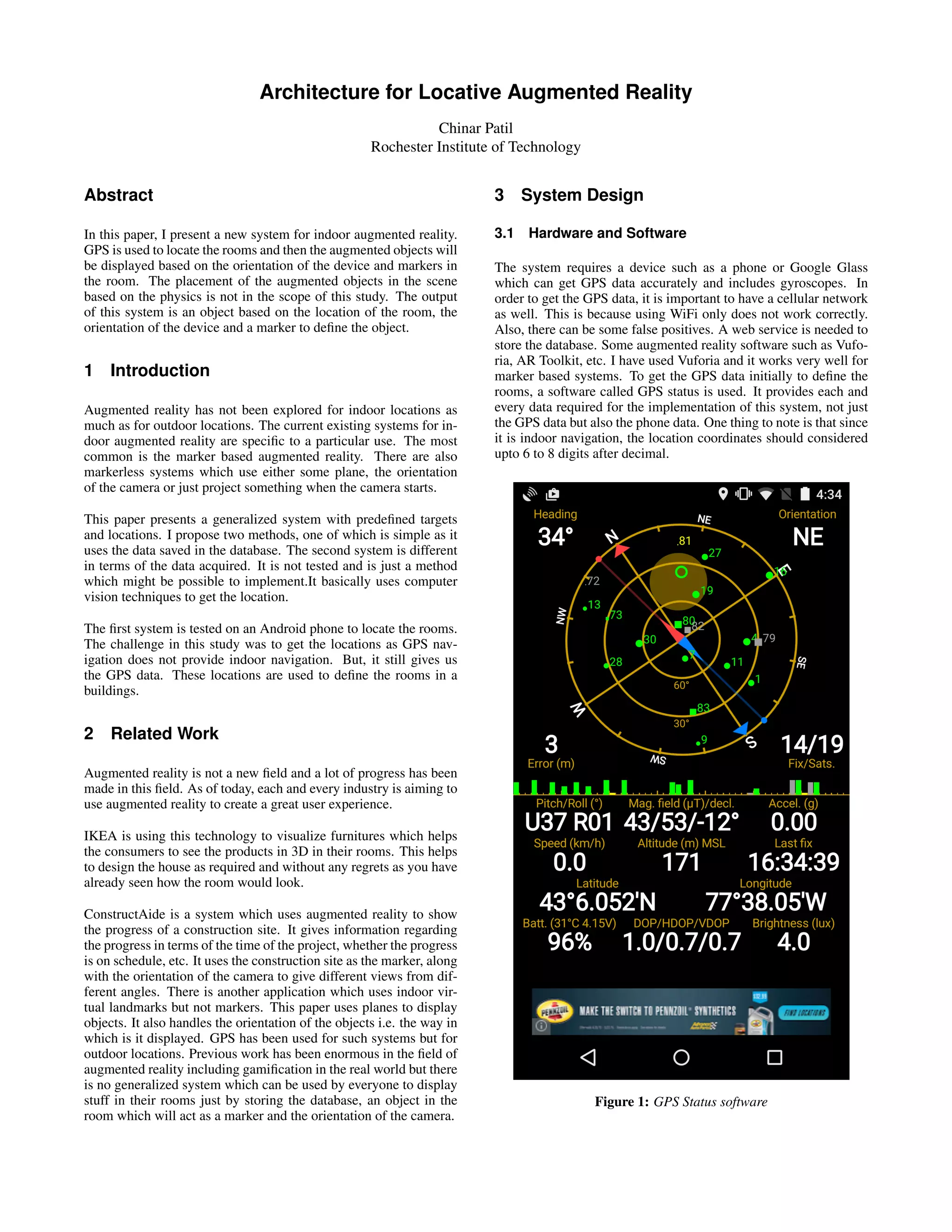
marker based systems. To get the GPS data initially to define the
rooms, a software called GPS status is used. It provides each and
every data required for the implementation of this system, not just
the GPS data but also the phone data. One thing to note is that since
it is indoor navigation, the location coordinates should considered
upto 6 to 8 digits after decimal.
Figure 1: GPS Status software
Figure 2: System Architecture
4 Implementation
The first step is to gather the data related to each object to be aug-
mented. This step is required for both methods. The data collected
should be same but the rooms location data will differ. This is be-
cause the systems calculate the locations differently. The first sys-
tem uses GPS and the second has a model of its own which will be
discussed further.
The markers are the objects in the room. These can be sockets, ta-
bles, or just a plain wall. When a person enters the room and holds
his phone towards the markers, he will see the corresponding ob-
jects. But there arises another problem. There are multiple sockets,
multiple tables in one room. You don’t want same objects for each
of them. This is why I decided to use the orientation of the camera.
The direction in which the camera is pointing will do the job in such
situations. This was about displaying the objects. Before this the
objects should be defined and linked to the markers.
I used Vuforia SDK and it provides a database of its own to define
the markers. This database is downloaded as an xml file which
will be used to select the appropriate marker based on the above
described conditions. In case of same markers, they are identified
by unique names. Currently, this system is limited to local usage.
It is not yet generalized.
To have a generalized system, there needs to be some modification
as it would be a platform instead of a running application. A plat-
form would allow an administrator, i.e a person who wants to use
this system for his building or house, to insert the data he gath-
ered, in the database. Also, I suggest to use independent Vuforia
databases for every administrator. A Vuforia database is where the
markers are stored. Having this database independent will allow
less or no conflicts between marker names. So, as the number of
administrators increase, the number of vuforia databases will also
increase. This arises another need, selecting the vuforia database.
This problem will be solved with the help of the GPS location of
the building. This GPS location is implemented in both the meth-
ods as this belongs to the outdoor location and you can easily locate
a building, unlike a room.
The generalized application would just be a framework to develop
upon for whoever is interested in augmenting their room.
4.1 Using GPS
I used Google Maps API to get the location coordinates of each
room. Although GPS does not provide indoor navigation, it does
provide the location coordinates. This gives the latitude, longitude
which is stored in the database. Four locations of four corners are
saved for every room. This can be changed based on the shape of
the room and applying the corresponding equations to check if the
person is inside the room. For example, a circular room can have
only its center and radius stored.
There can be many ways to design the database in order to access
the correct marker. One of which can be storing the shape of room
and based on the shape it will be checked if the device is inside the
room. The code will continue to check and match whether you are
inside a room. This selects the room and then comes the selection
of the markers. This is implemented by first checking angle or ori-
entation of the phone and based on the orientation, get the name of
the marker. Now, since the first check locates the building and then
we locate the room corresponding to that building, having duplicate
names for markers by different administrators won’t be a problem.
After getting the marker name from the database, hand it over to
vuforia.
Vuforia will do the image recognition and display the correspond-
ing objects. This can be modified a bit by using the orientation
after the image recognition step. This will give better performance
as compared to the other way. Image recognition shows the aug-
mented object as long as the marker is visible to the camera but
if the orientation is checked first, there is a possibility that even if
the marker is in range, it won’t display as it never gets into image
recognition. One thing to manage is the orientation range. Database
has only one value but when checking in the code, there should be
a range in all four direction - left, right, up, down.
4.2 Create Your Map
This is a difficult method to implement. It can be a project of its
own. This is mainly for indoor navigation. I propose the use of
computer vision techniques in this system to create a map of the
building so you can navigate inside and get the location values. I
won’t be discussing the techniques to be used for getting the map.
It is just a possibility as I haven’t implemented. I will talk about the
results that can be obtained from this technique and how the data
can be used. There is no GPS in this case for indoor navigation, it’s
only for locating the building.
In order for the administrator to provide the location specific data
inside the building, he needs a floor map. The floor map will be
scanned by a system running computer vision algorithms to get the
boundaries of the rooms. There is also a need to get the dimensions
of the rooms. For this, the floor map should have the dimensions
mentioned on it. Now, the algorithm should be able to read these
numbers and build a virtual map of its own. This is the method
I thought about at the beginning of the study. But eventually it
turned out that there is no need for the map, since the next step I
had thought of was can be independent of this step.
All that is needed is some location specific data to identify the
rooms. For this, I propose the use of accelerometers to get the
distance of the device from some predefined point in the building
on that floor. Accelerometer doesn’t give the direct distance data.
Some algorithm should be implemented to do this. There are many
applications which give the distance covered by a person. But this
won’t do the job. This system needs the distance from some pivot
point and it should decrease if the person approaches the pivot. This
is very difficult and turns out that it is much more challenging when
you try to implement it. In order to the reverse motion i.e. going
back to the pivot, again the orientation needs to be used. Thus mon-
itoring the device at every point and calculating the distance from
the pivot. This is a flawed concept as of now but there should be
some way to make it possible.
I will assume that we have what we want and go on with the next
step. So, as of now, we have a system that measures the distance
from some predefined point. The user needs to start the application
at this point in order to make it work. Thats the way in which he can
get the correct locations. Also, every floor in the building will have
this system independently and there has to be some way to figure
out the floor number. Currently, this can be entered by the user.
The administrator of that building will find the corresponding data
and have it in the database, just like the GPS method. Everything
else will be similar to the GPS method.
The question arises that why would anyone try to implement such a
complicated system which is flawed. The answer to this question is
because I had thought of this method before I went to GPS. I have
been researching in indoor navigation system systems, as GPS does
not provide navigation, which lead me to this path. I realized that
GPS does give data inside the building and that is when I switched
to the other method.
Although it is complicated, it sounds like a good concept to me and
can be refined and implemented with some other objectives.
Figure 3: Vuforia image target using marker
5 Discussion
I have implemented the system to check if it works for the room
identification. I used an Android Phone, Vuforia SDK and a
MySQL database. I have tested the augmented reality and room
detection parts independently. The system is not implemented com-
pletely. It works fine and can be easy to implement the whole
system using GPS. GPS has one problem that it does not update
quickly sometimes. The connection can be a problem at times.
A cellular network should help to overcome this problem. I have
tested this only with WiFi which also works good.
In case of the second method, it is just a technique which can be ex-
plored further. With the advent of new technologies such as Google
Tango and Microsoft HoloLens, it seems everything has been ex-
plored. It is my personal opinion that the second system can be
used to build onto something.
6 Conclusion
I have proposed a system architecture for indoor augmented reality.
In order to achieve this system, I have proposed two methods, one
using GPS as the main element to identify locations and the other
is using mobile device’s accelerometer data or some other distance
calculation technique to get the location of the device. The second
method is not tested at any extent and is not feasible for this sys-
tem. Though it can be used to implement another indoor navigation
system. The GPS method works very good and is tested to set the
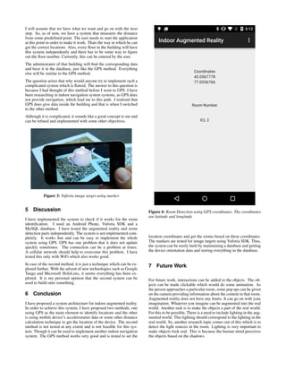
Figure 4: Room Detection using GPS coordinates. The coordinates
are latitude and longitude
location coordinates and get the rooms based on these coordinates.
The markers are tested for image targets using Vuforia SDK. Thus,
the system can be easily built by maintaining a database and getting
the device orientation data and storing everything in the database.
7 Future Work
For future work, interactions can be added to the objects. The ob-
jects can be made clickable which would do some animation. As
the person approaches a particular room, some pop ups can be given
on the camera providing information about the content in that room.
Augmented reality does not have any limits. It can go on with your
imagination. Whatever you imagine can be augmented into the real
world. Another task is to make the objects a part of the real world.
For this to be possible, There is a need to include lighting in the aug-
mented world. This lighting should correspond to the lighting in the
real world. So, another research topic comes out of this which is to
detect the light sources in the room. Lighting is very important to
make objects look real. This is because the human mind perceives
the objects based on the shadows.
8 References
[1] Exploring the Evolution of Mobile Augmented Reality for Fu-
ture Entertainment Systems: Klen Copic Pucihar, Lancaster Uni-
versity, School of Computing and Communications, UK; Paul
Colton, Lancaster University, School of Computing and Commu-
nications, UK; June 2013.
[2] ConstructAide: Analyzing and Visualizing Construction Sites
through Photographs and Building Models: Kevin Karsch, Univer-
sity of Illinois; Mani Golparvar-Fard, University of Illinois; David
Forsyth, University of Illinois; November 2014.
[3] Orientation control for indoor virtual landmarks based on hy-
brid based markerless augmented reality: Fadhil Noer Afif, Ah-
mad Hoirul Basori; Faculty of Computing, Universiti Teknologi
Malaysia, 81310 UTM Skudai, Johor Darul Takzim, Malaysia;
November 2013.
[4] Qualcomm Vuforia SDK to implement the augmented reality
system

More Related Content

What's hot

Image recognition
Image recognitionImage recognition
Image recognition
Joel Jose
 
An Assessment of Image Matching Algorithms in Depth Estimation
An Assessment of Image Matching Algorithms in Depth EstimationAn Assessment of Image Matching Algorithms in Depth Estimation
An Assessment of Image Matching Algorithms in Depth Estimation
CSCJournals
 
Enhanced Optimization of Edge Detection for High Resolution Images Using Veri...
Enhanced Optimization of Edge Detection for High Resolution Images Using Veri...Enhanced Optimization of Edge Detection for High Resolution Images Using Veri...
Enhanced Optimization of Edge Detection for High Resolution Images Using Veri...
ijcisjournal
 
Interactive full body motion capture using infrared sensor network
Interactive full body motion capture using infrared sensor networkInteractive full body motion capture using infrared sensor network
Interactive full body motion capture using infrared sensor network
ijcga
 
A Genetic Algorithm-Based Moving Object Detection For Real-Time Traffic Surv...
 A Genetic Algorithm-Based Moving Object Detection For Real-Time Traffic Surv... A Genetic Algorithm-Based Moving Object Detection For Real-Time Traffic Surv...
A Genetic Algorithm-Based Moving Object Detection For Real-Time Traffic Surv...
Chennai Networks
 
30 ball
30 ball30 ball
Video surveillance Moving object detection& tracking Chapter 1
Video surveillance Moving object detection& tracking Chapter 1 Video surveillance Moving object detection& tracking Chapter 1
Video surveillance Moving object detection& tracking Chapter 1
ahmed mokhtar
 
Final_draft_Practice_School_II_report
Final_draft_Practice_School_II_reportFinal_draft_Practice_School_II_report
Final_draft_Practice_School_II_reportRishikesh Bagwe
 
SD-miner System to Retrieve Probabilistic Neighborhood Points in Spatial Dat...
SD-miner System to Retrieve Probabilistic Neighborhood Points  in Spatial Dat...SD-miner System to Retrieve Probabilistic Neighborhood Points  in Spatial Dat...
SD-miner System to Retrieve Probabilistic Neighborhood Points in Spatial Dat...
IOSR Journals
 
Parameterized Image Filtering Using fuzzy Logic
Parameterized Image Filtering Using fuzzy LogicParameterized Image Filtering Using fuzzy Logic
Parameterized Image Filtering Using fuzzy Logic
Editor IJCATR
 
HUMAN MOTION DETECTION AND TRACKING FOR VIDEO SURVEILLANCE
HUMAN MOTION  DETECTION AND TRACKING FOR VIDEO SURVEILLANCEHUMAN MOTION  DETECTION AND TRACKING FOR VIDEO SURVEILLANCE
HUMAN MOTION DETECTION AND TRACKING FOR VIDEO SURVEILLANCE
NEHA THADEUS
 
Sixth sense cloud computing
Sixth sense cloud computingSixth sense cloud computing
Sixth sense cloud computing
yugank srivastava
 
Properties of Images in LSB Plane
Properties of Images in LSB PlaneProperties of Images in LSB Plane
Properties of Images in LSB Plane
IOSR Journals
 
Introduction to Kinect - Update v 1.8
Introduction to Kinect - Update v 1.8Introduction to Kinect - Update v 1.8
Introduction to Kinect - Update v 1.8
Matteo Valoriani
 
Ear Biometrics shritosh kumar
Ear Biometrics shritosh kumarEar Biometrics shritosh kumar
Ear Biometrics shritosh kumar
shritosh kumar
 

What's hot (20)

Image recognition
Image recognitionImage recognition
Image recognition
 
An Assessment of Image Matching Algorithms in Depth Estimation
An Assessment of Image Matching Algorithms in Depth EstimationAn Assessment of Image Matching Algorithms in Depth Estimation
An Assessment of Image Matching Algorithms in Depth Estimation
 
Moving object detection1
Moving object detection1Moving object detection1
Moving object detection1
 
Object recognition
Object recognitionObject recognition
Object recognition
 
L0816166
L0816166L0816166
L0816166
 
BAXTER PLAYING POOL
BAXTER PLAYING POOLBAXTER PLAYING POOL
BAXTER PLAYING POOL
 
Enhanced Optimization of Edge Detection for High Resolution Images Using Veri...
Enhanced Optimization of Edge Detection for High Resolution Images Using Veri...Enhanced Optimization of Edge Detection for High Resolution Images Using Veri...
Enhanced Optimization of Edge Detection for High Resolution Images Using Veri...
 
Interactive full body motion capture using infrared sensor network
Interactive full body motion capture using infrared sensor networkInteractive full body motion capture using infrared sensor network
Interactive full body motion capture using infrared sensor network
 
A Genetic Algorithm-Based Moving Object Detection For Real-Time Traffic Surv...
 A Genetic Algorithm-Based Moving Object Detection For Real-Time Traffic Surv... A Genetic Algorithm-Based Moving Object Detection For Real-Time Traffic Surv...
A Genetic Algorithm-Based Moving Object Detection For Real-Time Traffic Surv...
 
30 ball
30 ball30 ball
30 ball
 
Video surveillance Moving object detection& tracking Chapter 1
Video surveillance Moving object detection& tracking Chapter 1 Video surveillance Moving object detection& tracking Chapter 1
Video surveillance Moving object detection& tracking Chapter 1
 
Final_draft_Practice_School_II_report
Final_draft_Practice_School_II_reportFinal_draft_Practice_School_II_report
Final_draft_Practice_School_II_report
 
SD-miner System to Retrieve Probabilistic Neighborhood Points in Spatial Dat...
SD-miner System to Retrieve Probabilistic Neighborhood Points  in Spatial Dat...SD-miner System to Retrieve Probabilistic Neighborhood Points  in Spatial Dat...
SD-miner System to Retrieve Probabilistic Neighborhood Points in Spatial Dat...
 
Parameterized Image Filtering Using fuzzy Logic
Parameterized Image Filtering Using fuzzy LogicParameterized Image Filtering Using fuzzy Logic
Parameterized Image Filtering Using fuzzy Logic
 
50120140501008
5012014050100850120140501008
50120140501008
 
HUMAN MOTION DETECTION AND TRACKING FOR VIDEO SURVEILLANCE
HUMAN MOTION  DETECTION AND TRACKING FOR VIDEO SURVEILLANCEHUMAN MOTION  DETECTION AND TRACKING FOR VIDEO SURVEILLANCE
HUMAN MOTION DETECTION AND TRACKING FOR VIDEO SURVEILLANCE
 
Sixth sense cloud computing
Sixth sense cloud computingSixth sense cloud computing
Sixth sense cloud computing
 
Properties of Images in LSB Plane
Properties of Images in LSB PlaneProperties of Images in LSB Plane
Properties of Images in LSB Plane
 
Introduction to Kinect - Update v 1.8
Introduction to Kinect - Update v 1.8Introduction to Kinect - Update v 1.8
Introduction to Kinect - Update v 1.8
 
Ear Biometrics shritosh kumar
Ear Biometrics shritosh kumarEar Biometrics shritosh kumar
Ear Biometrics shritosh kumar
 

Similar to Architecture for Locative Augmented Reality

Binocular Search Engine Using Android
Binocular Search Engine Using AndroidBinocular Search Engine Using Android
IRJET- Augmented Reality in Interior Design
IRJET- Augmented Reality in Interior DesignIRJET- Augmented Reality in Interior Design
IRJET- Augmented Reality in Interior Design
IRJET Journal
 
Location Provider with Privacy Using Localized Server and GPS
  Location Provider with Privacy Using Localized Server and GPS   Location Provider with Privacy Using Localized Server and GPS
Location Provider with Privacy Using Localized Server and GPS
Editor IJCATR
 
Indoor gps via QR codes
Indoor gps via QR codesIndoor gps via QR codes
Indoor gps via QR codes
Vaibhav Sharma
 
Gesture detection by virtual surface
Gesture detection by virtual surfaceGesture detection by virtual surface
Gesture detection by virtual surfaceAshish Garg
 
IRJET- Profile Management System
IRJET- Profile Management SystemIRJET- Profile Management System
IRJET- Profile Management System
IRJET Journal
 
Indoor localization Leveraging Human Perception of Textual Signs
Indoor localization Leveraging Human Perception of Textual SignsIndoor localization Leveraging Human Perception of Textual Signs
Indoor localization Leveraging Human Perception of Textual Signs
Shekhar Vimalendu
 
IRJET- A System for Indoor Navigation: GuideIt - Personal Assistant
IRJET-  	  A System for Indoor Navigation: GuideIt - Personal AssistantIRJET-  	  A System for Indoor Navigation: GuideIt - Personal Assistant
IRJET- A System for Indoor Navigation: GuideIt - Personal Assistant
IRJET Journal
 
Brown University Robotics Final Paper 2010
Brown University Robotics Final Paper 2010Brown University Robotics Final Paper 2010
Brown University Robotics Final Paper 2010Kwame Martin
 
Location based services using augmented reality
Location based services using augmented realityLocation based services using augmented reality
Location based services using augmented realityIAEME Publication
 
Augmented reality
Augmented realityAugmented reality
Augmented reality
Anugya Shukla
 
Google Project Tango
Google Project TangoGoogle Project Tango
Google Project Tango
Akhil Nair
 
Graphics
GraphicsGraphics
Graphics
prakash sarkar
 
10.1109@ICCMC48092.2020.ICCMC-000167.pdf
10.1109@ICCMC48092.2020.ICCMC-000167.pdf10.1109@ICCMC48092.2020.ICCMC-000167.pdf
10.1109@ICCMC48092.2020.ICCMC-000167.pdf
mokamojah
 
Smart Way to Track the Location in Android Operating System
Smart Way to Track the Location in Android Operating SystemSmart Way to Track the Location in Android Operating System
Smart Way to Track the Location in Android Operating System
IOSR Journals
 
Tango
TangoTango
Tango
mohd aijaj
 
Comparative study of augmented reality
Comparative study of augmented realityComparative study of augmented reality
Comparative study of augmented reality
ijcsa
 
Interior Designing Mobile Application based on Markerless Augmented Reality (AR)
Interior Designing Mobile Application based on Markerless Augmented Reality (AR)Interior Designing Mobile Application based on Markerless Augmented Reality (AR)
Interior Designing Mobile Application based on Markerless Augmented Reality (AR)
IRJET Journal
 
Design of Image Projection Using Combined Approach for Tracking
Design of Image Projection Using Combined Approach for  TrackingDesign of Image Projection Using Combined Approach for  Tracking
Design of Image Projection Using Combined Approach for Tracking
IJMER
 
Extraction of Buildings from Satellite Images
Extraction of Buildings from Satellite ImagesExtraction of Buildings from Satellite Images
Extraction of Buildings from Satellite Images
Akanksha Prasad
 

Similar to Architecture for Locative Augmented Reality (20)

Binocular Search Engine Using Android
Binocular Search Engine Using AndroidBinocular Search Engine Using Android
Binocular Search Engine Using Android
 
IRJET- Augmented Reality in Interior Design
IRJET- Augmented Reality in Interior DesignIRJET- Augmented Reality in Interior Design
IRJET- Augmented Reality in Interior Design
 
Location Provider with Privacy Using Localized Server and GPS
  Location Provider with Privacy Using Localized Server and GPS   Location Provider with Privacy Using Localized Server and GPS
Location Provider with Privacy Using Localized Server and GPS
 
Indoor gps via QR codes
Indoor gps via QR codesIndoor gps via QR codes
Indoor gps via QR codes
 
Gesture detection by virtual surface
Gesture detection by virtual surfaceGesture detection by virtual surface
Gesture detection by virtual surface
 
IRJET- Profile Management System
IRJET- Profile Management SystemIRJET- Profile Management System
IRJET- Profile Management System
 
Indoor localization Leveraging Human Perception of Textual Signs
Indoor localization Leveraging Human Perception of Textual SignsIndoor localization Leveraging Human Perception of Textual Signs
Indoor localization Leveraging Human Perception of Textual Signs
 
IRJET- A System for Indoor Navigation: GuideIt - Personal Assistant
IRJET-  	  A System for Indoor Navigation: GuideIt - Personal AssistantIRJET-  	  A System for Indoor Navigation: GuideIt - Personal Assistant
IRJET- A System for Indoor Navigation: GuideIt - Personal Assistant
 
Brown University Robotics Final Paper 2010
Brown University Robotics Final Paper 2010Brown University Robotics Final Paper 2010
Brown University Robotics Final Paper 2010
 
Location based services using augmented reality
Location based services using augmented realityLocation based services using augmented reality
Location based services using augmented reality
 
Augmented reality
Augmented realityAugmented reality
Augmented reality
 
Google Project Tango
Google Project TangoGoogle Project Tango
Google Project Tango
 
Graphics
GraphicsGraphics
Graphics
 
10.1109@ICCMC48092.2020.ICCMC-000167.pdf
10.1109@ICCMC48092.2020.ICCMC-000167.pdf10.1109@ICCMC48092.2020.ICCMC-000167.pdf
10.1109@ICCMC48092.2020.ICCMC-000167.pdf
 
Smart Way to Track the Location in Android Operating System
Smart Way to Track the Location in Android Operating SystemSmart Way to Track the Location in Android Operating System
Smart Way to Track the Location in Android Operating System
 
Tango
TangoTango
Tango
 
Comparative study of augmented reality
Comparative study of augmented realityComparative study of augmented reality
Comparative study of augmented reality
 
Interior Designing Mobile Application based on Markerless Augmented Reality (AR)
Interior Designing Mobile Application based on Markerless Augmented Reality (AR)Interior Designing Mobile Application based on Markerless Augmented Reality (AR)
Interior Designing Mobile Application based on Markerless Augmented Reality (AR)
 
Design of Image Projection Using Combined Approach for Tracking
Design of Image Projection Using Combined Approach for  TrackingDesign of Image Projection Using Combined Approach for  Tracking
Design of Image Projection Using Combined Approach for Tracking
 
Extraction of Buildings from Satellite Images
Extraction of Buildings from Satellite ImagesExtraction of Buildings from Satellite Images
Extraction of Buildings from Satellite Images
 

Architecture for Locative Augmented Reality

  • 1. Architecture for Locative Augmented Reality Chinar Patil Rochester Institute of Technology Abstract In this paper, I present a new system for indoor augmented reality. GPS is used to locate the rooms and then the augmented objects will be displayed based on the orientation of the device and markers in the room. The placement of the augmented objects in the scene based on the physics is not in the scope of this study. The output of this system is an object based on the location of the room, the orientation of the device and a marker to define the object. 1 Introduction Augmented reality has not been explored for indoor locations as much as for outdoor locations. The current existing systems for in- door augmented reality are specific to a particular use. The most common is the marker based augmented reality. There are also markerless systems which use either some plane, the orientation of the camera or just project something when the camera starts. This paper presents a generalized system with predefined targets and locations. I propose two methods, one of which is simple as it uses the data saved in the database. The second system is different in terms of the data acquired. It is not tested and is just a method which might be possible to implement.It basically uses computer vision techniques to get the location. The first system is tested on an Android phone to locate the rooms. The challenge in this study was to get the locations as GPS nav- igation does not provide indoor navigation. But, it still gives us the GPS data. These locations are used to define the rooms in a buildings. 2 Related Work Augmented reality is not a new field and a lot of progress has been made in this field. As of today, each and every industry is aiming to use augmented reality to create a great user experience. IKEA is using this technology to visualize furnitures which helps the consumers to see the products in 3D in their rooms. This helps to design the house as required and without any regrets as you have already seen how the room would look. ConstructAide is a system which uses augmented reality to show the progress of a construction site. It gives information regarding the progress in terms of the time of the project, whether the progress is on schedule, etc. It uses the construction site as the marker, along with the orientation of the camera to give different views from dif- ferent angles. There is another application which uses indoor vir- tual landmarks but not markers. This paper uses planes to display objects. It also handles the orientation of the objects i.e. the way in which is it displayed. GPS has been used for such systems but for outdoor locations. Previous work has been enormous in the field of augmented reality including gamification in the real world but there is no generalized system which can be used by everyone to display stuff in their rooms just by storing the database, an object in the room which will act as a marker and the orientation of the camera. 3 System Design 3.1 Hardware and Software The system requires a device such as a phone or Google Glass which can get GPS data accurately and includes gyroscopes. In order to get the GPS data, it is important to have a cellular network as well. This is because using WiFi only does not work correctly. Also, there can be some false positives. A web service is needed to store the database. Some augmented reality software such as Vufo- ria, AR Toolkit, etc. I have used Vuforia and it works very well for marker based systems. To get the GPS data initially to define the rooms, a software called GPS status is used. It provides each and every data required for the implementation of this system, not just the GPS data but also the phone data. One thing to note is that since it is indoor navigation, the location coordinates should considered upto 6 to 8 digits after decimal. Figure 1: GPS Status software
  • 2. Figure 2: System Architecture 4 Implementation The first step is to gather the data related to each object to be aug- mented. This step is required for both methods. The data collected should be same but the rooms location data will differ. This is be- cause the systems calculate the locations differently. The first sys- tem uses GPS and the second has a model of its own which will be discussed further. The markers are the objects in the room. These can be sockets, ta- bles, or just a plain wall. When a person enters the room and holds his phone towards the markers, he will see the corresponding ob- jects. But there arises another problem. There are multiple sockets, multiple tables in one room. You don’t want same objects for each of them. This is why I decided to use the orientation of the camera. The direction in which the camera is pointing will do the job in such situations. This was about displaying the objects. Before this the objects should be defined and linked to the markers. I used Vuforia SDK and it provides a database of its own to define the markers. This database is downloaded as an xml file which will be used to select the appropriate marker based on the above described conditions. In case of same markers, they are identified by unique names. Currently, this system is limited to local usage. It is not yet generalized. To have a generalized system, there needs to be some modification as it would be a platform instead of a running application. A plat- form would allow an administrator, i.e a person who wants to use this system for his building or house, to insert the data he gath- ered, in the database. Also, I suggest to use independent Vuforia databases for every administrator. A Vuforia database is where the markers are stored. Having this database independent will allow less or no conflicts between marker names. So, as the number of administrators increase, the number of vuforia databases will also increase. This arises another need, selecting the vuforia database. This problem will be solved with the help of the GPS location of the building. This GPS location is implemented in both the meth- ods as this belongs to the outdoor location and you can easily locate a building, unlike a room. The generalized application would just be a framework to develop upon for whoever is interested in augmenting their room. 4.1 Using GPS I used Google Maps API to get the location coordinates of each room. Although GPS does not provide indoor navigation, it does provide the location coordinates. This gives the latitude, longitude which is stored in the database. Four locations of four corners are saved for every room. This can be changed based on the shape of the room and applying the corresponding equations to check if the person is inside the room. For example, a circular room can have only its center and radius stored. There can be many ways to design the database in order to access the correct marker. One of which can be storing the shape of room and based on the shape it will be checked if the device is inside the room. The code will continue to check and match whether you are inside a room. This selects the room and then comes the selection of the markers. This is implemented by first checking angle or ori- entation of the phone and based on the orientation, get the name of the marker. Now, since the first check locates the building and then we locate the room corresponding to that building, having duplicate names for markers by different administrators won’t be a problem. After getting the marker name from the database, hand it over to vuforia. Vuforia will do the image recognition and display the correspond- ing objects. This can be modified a bit by using the orientation after the image recognition step. This will give better performance as compared to the other way. Image recognition shows the aug- mented object as long as the marker is visible to the camera but if the orientation is checked first, there is a possibility that even if the marker is in range, it won’t display as it never gets into image recognition. One thing to manage is the orientation range. Database has only one value but when checking in the code, there should be a range in all four direction - left, right, up, down. 4.2 Create Your Map This is a difficult method to implement. It can be a project of its own. This is mainly for indoor navigation. I propose the use of computer vision techniques in this system to create a map of the building so you can navigate inside and get the location values. I won’t be discussing the techniques to be used for getting the map. It is just a possibility as I haven’t implemented. I will talk about the results that can be obtained from this technique and how the data can be used. There is no GPS in this case for indoor navigation, it’s only for locating the building. In order for the administrator to provide the location specific data inside the building, he needs a floor map. The floor map will be scanned by a system running computer vision algorithms to get the boundaries of the rooms. There is also a need to get the dimensions of the rooms. For this, the floor map should have the dimensions mentioned on it. Now, the algorithm should be able to read these numbers and build a virtual map of its own. This is the method I thought about at the beginning of the study. But eventually it turned out that there is no need for the map, since the next step I had thought of was can be independent of this step. All that is needed is some location specific data to identify the rooms. For this, I propose the use of accelerometers to get the distance of the device from some predefined point in the building on that floor. Accelerometer doesn’t give the direct distance data. Some algorithm should be implemented to do this. There are many applications which give the distance covered by a person. But this won’t do the job. This system needs the distance from some pivot point and it should decrease if the person approaches the pivot. This is very difficult and turns out that it is much more challenging when you try to implement it. In order to the reverse motion i.e. going back to the pivot, again the orientation needs to be used. Thus mon- itoring the device at every point and calculating the distance from the pivot. This is a flawed concept as of now but there should be some way to make it possible.
  • 3. I will assume that we have what we want and go on with the next step. So, as of now, we have a system that measures the distance from some predefined point. The user needs to start the application at this point in order to make it work. Thats the way in which he can get the correct locations. Also, every floor in the building will have this system independently and there has to be some way to figure out the floor number. Currently, this can be entered by the user. The administrator of that building will find the corresponding data and have it in the database, just like the GPS method. Everything else will be similar to the GPS method. The question arises that why would anyone try to implement such a complicated system which is flawed. The answer to this question is because I had thought of this method before I went to GPS. I have been researching in indoor navigation system systems, as GPS does not provide navigation, which lead me to this path. I realized that GPS does give data inside the building and that is when I switched to the other method. Although it is complicated, it sounds like a good concept to me and can be refined and implemented with some other objectives. Figure 3: Vuforia image target using marker 5 Discussion I have implemented the system to check if it works for the room identification. I used an Android Phone, Vuforia SDK and a MySQL database. I have tested the augmented reality and room detection parts independently. The system is not implemented com- pletely. It works fine and can be easy to implement the whole system using GPS. GPS has one problem that it does not update quickly sometimes. The connection can be a problem at times. A cellular network should help to overcome this problem. I have tested this only with WiFi which also works good. In case of the second method, it is just a technique which can be ex- plored further. With the advent of new technologies such as Google Tango and Microsoft HoloLens, it seems everything has been ex- plored. It is my personal opinion that the second system can be used to build onto something. 6 Conclusion I have proposed a system architecture for indoor augmented reality. In order to achieve this system, I have proposed two methods, one using GPS as the main element to identify locations and the other is using mobile device’s accelerometer data or some other distance calculation technique to get the location of the device. The second method is not tested at any extent and is not feasible for this sys- tem. Though it can be used to implement another indoor navigation system. The GPS method works very good and is tested to set the Figure 4: Room Detection using GPS coordinates. The coordinates are latitude and longitude location coordinates and get the rooms based on these coordinates. The markers are tested for image targets using Vuforia SDK. Thus, the system can be easily built by maintaining a database and getting the device orientation data and storing everything in the database. 7 Future Work For future work, interactions can be added to the objects. The ob- jects can be made clickable which would do some animation. As the person approaches a particular room, some pop ups can be given on the camera providing information about the content in that room. Augmented reality does not have any limits. It can go on with your imagination. Whatever you imagine can be augmented into the real world. Another task is to make the objects a part of the real world. For this to be possible, There is a need to include lighting in the aug- mented world. This lighting should correspond to the lighting in the real world. So, another research topic comes out of this which is to detect the light sources in the room. Lighting is very important to make objects look real. This is because the human mind perceives the objects based on the shadows.
  • 4. 8 References [1] Exploring the Evolution of Mobile Augmented Reality for Fu- ture Entertainment Systems: Klen Copic Pucihar, Lancaster Uni- versity, School of Computing and Communications, UK; Paul Colton, Lancaster University, School of Computing and Commu- nications, UK; June 2013. [2] ConstructAide: Analyzing and Visualizing Construction Sites through Photographs and Building Models: Kevin Karsch, Univer- sity of Illinois; Mani Golparvar-Fard, University of Illinois; David Forsyth, University of Illinois; November 2014. [3] Orientation control for indoor virtual landmarks based on hy- brid based markerless augmented reality: Fadhil Noer Afif, Ah- mad Hoirul Basori; Faculty of Computing, Universiti Teknologi Malaysia, 81310 UTM Skudai, Johor Darul Takzim, Malaysia; November 2013. [4] Qualcomm Vuforia SDK to implement the augmented reality system