Download to read offline
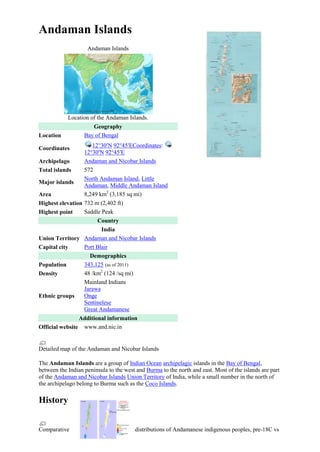
![present-day
Early inhabitants
The Andaman islands have been inhabited for several thousand years, at the very least. The earliest
archaeological evidence yet documented goes back some 2,200 years; however, the indications from
genetic, cultural and isolation studies suggests that it may have been in the Middle Paleolithic.[1] The
indigenous Andamanese people appear to have lived on the islands in substantial isolation from that
time until the 18th century CE.
The Andamans are theorized to be a key stepping stone in a great coastal migration of humans from
Africa via the Arabian peninsula, along the coastal regions of the Indian mainland and towards
Southeast Asia, Japan and Oceania.[2]
Traveler reports
The name of the Andaman Islands is ancient. A theory that became prevalent since the late 19th
century is that it derives from Hanuman, the Malay form of Hanuman, the Sanskrit name of the Indian
monkey-god.[3][4]
The name first appears in the work of Arab geographers of the 9th century (Soleyman in 851).[citation
needed]
It is possible that ancient geographers like Ptolemy also knew of the Andamans but referred to
them by a different name. The Persian navigator Buzurg ibn Shahriyar of Ramhormuz, in his 10th
century book Ajaib al-Hind (The wonders of India) described the islands as being inhabited by fierce
cannibalistic tribes. The book also mentions an island he called Andaman al-Kabir (Great
Andaman).[5][6]
The Andaman and Nicobar islands are called Timaittivu ("impure islands" in Tamil) in Chola Dynasty
chronicles.[7]
Marco Polo briefly mentions the Andamans (calling them Angamanain), though it is uncertain
whether he visited the islands and if he did, whether he met the natives, because he describes them as
having heads like dogs.[8][9] Another Italian traveler, Niccolò de' Conti (c. 1440), mentioned the
islands and said that the name means "Island of Gold".
Chola empire
From 800 to 1200 AD, the Tamil Chola dynasty created an empire that eventually extended from
southeastern peninsular India to parts of Malaysia.[10] Rajendra Chola I (1014 to 1042 CE) occupied
the Andaman and Nicobar Islands to use them as a strategic naval base to launch a naval expedition
against the Sriwijaya empire (a Hindu-Malay empire based on the island of Sumatra, Indonesia).
Maratha empire
The Maratha admiral Kanhoji Angre used the Andamans as a base and "fought the British off these
islands until his death in 1729." [11][12]
British colonization and penal colony
In 1789, the government of Bengal established a naval base and penal colony on Chatham Island in
the southeast bay of Great Andaman. The settlement is now known as Port Blair (after the Bombay
Marine lieutenant Archibald Blair who founded it). After two years, the colony was moved to the
northeast part of Great Andaman and was named Port Cornwallis after Admiral William Cornwallis.
However, there was much disease and death in the penal colony and the government ceased operating
it in May 1796.[11]
In 1824, Port Cornwallis was the rendezvous of the fleet carrying the army to the First Burmese War.
In the 1830s and 1840s, shipwrecked crews who landed on the Andamans were often attacked and](https://image.slidesharecdn.com/andamanislands-131219223644-phpapp01/85/Andaman-islands-2-320.jpg)
![killed by the natives, alarming the British government. In 1855, the government proposed another
settlement on the islands, including a convict establishment, but the Indian Rebellion of 1857 forced a
delay in its construction. However, because the rebellion gave the British so many prisoners, it made
the new Andaman settlement and prison urgently necessary. Construction began in November 1857 at
Port Blair using inmates' labor, avoiding the vicinity of a salt swamp that seemed to have been the
source of many of the earlier problems at Port Cornwallis.
In 1867, the ship Nineveh wrecked on the reef of North Sentinel Island. The 86 survivors reached the
beach in the ship's boats. On the third day, they were attacked with iron-tipped spears by naked
islanders. One person from the ship escaped in a boat and the others were later rescued by a British
Royal Navy ship.[13]
For some time, sickness and mortality were high, but swamp reclamation and extensive forest
clearance continued. The Andaman colony became notorious with the murder of the Viceroy Richard
Southwell Bourke, 6th Earl of Mayo, on a visit to the settlement (8 February 1872), by a Muslim
convict, a Pathan from Afghanistan, Sher Ali. In the same year, the two island groups Andaman and
Nicobar, were united under a chief commissioner residing at Port Blair.
The Ross Island prison headquarters, 1872
From the time of its development in 1858 under the direction of James Pattison Walker, and in
response to the mutiny and rebellion of the previous year, the settlement was first and foremost a
repository for political prisoners. The Cellular Jail at Port Blair when completed in 1910 included 698
cells designed for solitary confinement; each cell measured 4.5 m (15 ft) by 2.7 m (9 ft) with a single
ventilation window 3 metres (10 ft) above the floor. A notable prisoner there was Vinayak Damodar
Savarkar.
The Indians imprisoned here referred to the Island and its prison as Kala Pani ("black water");[14] a
1996 film set on the island took that term as its title Kaalapani.[15]). The number of prisoners who died
in this camp is estimated to be in the thousands.[16] Many more died of harsh treatment and the harsh
living and working conditions in this camp.[17]
The Viper Chain Gang Jail on Viper Island was reserved for troublemakers, and was also the site of
hangings. In the 20th century, it became a convenient place to house prominent members of India's
independence movement.
Japanese occupation
Ross Island in 2004](https://image.slidesharecdn.com/andamanislands-131219223644-phpapp01/85/Andaman-islands-3-320.jpg)
![Andaman Islands
The Andaman and Nicobar islands were occupied by Japan during World War II.[18] The islands were
nominally put under the authority of the Arzi Hukumat-e-Azad Hind (Provisional Government of Free
India) headed by Netaji Subhas Chandra Bose. Netaji visited the islands during the war, and renamed
them as Shaheed (Martyr) & Swaraj (Self-rule). On 30 December 1943, during the Japanese
occupation, Subhas Chandra Bose, who was controversially allied with the Japanese, first raised the
flag of Indian independence. General Loganathan, of the Indian National Army, was Governor of the
Andaman and Nicobar Islands, which had been annexed to the Provisional Government. Before
leaving the islands, the Japanese rounded up and executed 750 civilians.[19] After the end of the war
the islands briefly returned to British control, before becoming part of the newly independent state of
India.
At the close of the World War II, the British government announced its intention to abolish the penal
settlement. The government proposed to employ former inmates in an initiative to develop the island's
fisheries, timber, and agricultural resources. In exchange inmates would be granted return passage to
the Indian mainland, or the right to settle on the islands. The penal colony was eventually closed on
15 August 1947 when India gained independence. It has since served as a museum to the
independence movement.
Recent history
In April 1998, American photographer John S Callahan organized the first surfing project in the
Andamans, starting from Phuket in Thailand with the assistance of Southeast Asia Liveaboards
(SEAL), a UK owned dive charter company. With a crew of international professional surfers, they
crossed the Andaman Sea on the yacht Crescent and cleared formalities in Port Blair. The group
proceeded to Little Andaman Island, where they spent ten days surfing several spots for the first time,
including Jarawa Point near Hut Bay and the long right reef point at the southwest tip of the island,
named Kumari Point. The resulting article in SURFER Magazine, "Quest for Fire" by journalist Sam
George, put the Andaman Islands on the surfing map for the first time.[20] Footage of the waves of the
Andaman Islands also appeared in the film "Thicker than Water", shot by cinematographer Jack
Johnson, who later achieved worldwide fame as a popular musician. Callahan went on to make
several more surfing projects in the Andamans, including a trip to the Nicobar Islands in 1999.
On 26 December 2004, the coast of the Andaman Islands was devastated by a 10-metre (33 ft) high
tsunami following the 2004 Indian Ocean earthquake. Strong oral traditions in the area warned of the
importance of moving inland after a quake and is credited with saving many lives. In the aftermath,
more than 2,000 people were confirmed dead and more than 4,000 children were orphaned or had lost
one parent. At least 40,000 residents were rendered homeless and were moved to relief camps.[21] On
11 August 2009, a magnitude 7 earthquake struck near the Andaman Islands, causing a tsunami
warning to go into effect. On 30 March 2010, a magnitude 6.9 earthquake struck near the Andaman
Islands.](https://image.slidesharecdn.com/andamanislands-131219223644-phpapp01/85/Andaman-islands-4-320.jpg)

The Andaman Islands are a group of islands located in the Bay of Bengal between India and Burma. The islands have been inhabited for thousands of years by indigenous tribes. They were colonized by the British in the 18th century, who established a penal colony on the islands. During World War 2, the islands were occupied by Japan. Today, the islands form a union territory of India with the capital in Port Blair. The islands were impacted by the 2004 Indian Ocean tsunami.


![[팀E] 미디어 프로젝트 기획서](https://cdn.slidesharecdn.com/ss_thumbnails/e-131219223829-phpapp02-thumbnail.jpg?width=640&height=640&fit=bounds)


