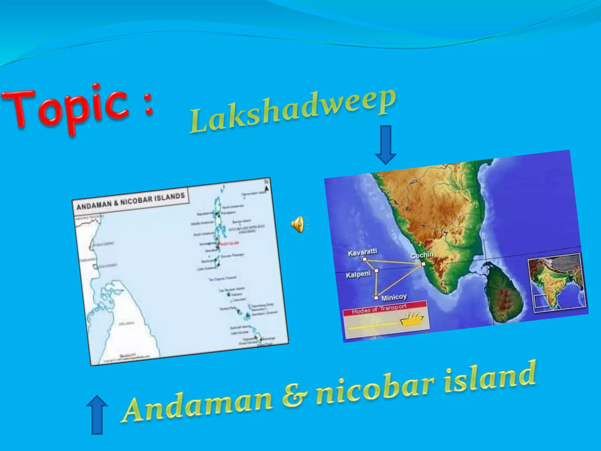
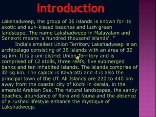
Coordinates (Port Blair)11.68°N 92.77°E Coordinates: 11.68°N 92.77°E
Established 1956-11-01
Capital Port Blair
Largest city Port Blair
Districts 3
Government
• Lt. Governor Lt. Gen. (Retd.) Bhopinder Singh
Area[1]
• Total 8,073 km2 (3,117 sq mi)
Population (2012)[2]
• Total 380,500
• Density 47/km2 (120/sq mi)
Time zone IST (UTC+05:30)
ISO 3166 code IN-AN
HDI 0.778 (High)
Official languages Bangla, English and Hindi[3] [4] tamil
Introduction
Palm leaves dancing in the mild breeze, powder white beaches,
the sound of waves breaking on a coral reef, lush, green rain
forests and chirping rare birds-this is what the Andaman and
Nicobar Islands essentially are. An archipelago of islands, islets
and rocks, this Union Territory of India is home to some of the
oldest tribes in the country. Though facilities for trekking,
diving and snorkelling are available here, the best way to enjoy
a trip to these islands is simply relax by the sea.
Flora and Fauna
The canopied rain forests of the islands harbor 3,000 species of plants
including mangroves, epiphytes (130 ferns, 100 orchids), palms,
woody climbers, timbers (teak, mahogany, Andaman paduk) and a
wide variety of tropical fruits. Marine fauna is diverse including a
wide variety of tropical fish and coral. Considering the diversity and
uniqueness of fauna and flora and the fragile nature of the eco-
system here, 96 sanctuaries spread over
People
Due to consistent emphasis of the government on progress and its
encouragement to the mainlanders to settle there has resulted in the local
tribes becoming a minority group in their own land. The indigenous tribes
are distinguished in two groups: the Onge, Sentinelese, Jarawa and
Andamanese of Negroid descent living on the Andaman Islands and the
Shompen and Nicobarese of Mongoloid descent living in the Nicobar Islands.
Most of the tribes are on the verge of extinction. This sad destiny will most
likely hit the Andamanese tribe first since their number is as low as thirty.
The Sentinelese is the least studied tribe still living in isolation on the North
Sentinel Island. Their number is estimated at 250. Outsiders attempting to
make contact with them are driven away with bows and arrows. They
continue to maintain a unique lifestyle living in harmony with nature just as
they have done for thousands of years.
Arts and Crafts
The main crafts of the Andaman & Nicobar Islands include shell and exotic woods
crafted for the tourists, palm mats, and beautiful natural shells. Due to the fear of
over exploitation of the Islands' natural resources, trade of some products .
Climate
The islands have a tropical climate. There is medium to heavy rain
during the monsoon, in the months from May to mid September and
November to mid December. There is no extreme climate except rains
and tropical storms in late summer often cause heavy damage
Industry
The Union Territory of Andaman and Nicobar Islands has a vast forest
resource base with 7,171 sq km of the total area of island covered by
forests. A large variety of timber is found in the Andaman group of
islands. The Islands have reported the occurrence of diatomaceous
earth, gold, limestone, nickel, selenite and sulphur. The Oil And Natural
Gas Commission is continuing the exploration for oil and gas there. The
Union Territory has a number of small scale, village and handicrafts
units. The number of export-oriented units is also increasing in the
agro-processing sectors. The Andaman and Nicobar Integrated
Development Corporation has made its presence felt in civil supplies,
tourism, fisheries, industries, and industrial financing activities.
Name Area (km2) Population
Census 2001
Population
Census 2011 Capital
Nicobar Islands 1,841 42,068 36,842 Car Nicobar
North and
Middle Andaman 3,736 105,613 105,597 Mayabunder
South Andaman 2,672 208,471 238,142 Port Blair
Totals 8,249 356,152 380,581
The areas and populations (at the 2001 and 2011 Censuses) of the
three districts are:
The Andaman and Nicobar Islands comprise around 572 islands formed by a
submarine mountain range, which separates the Bay of Bengal from the
Andaman Sea. The islands attain maximum altitude at Saddle Peak (730 m),
formed mainly of limestone, sandstone, and clay.
Area : 8,249 sq km
Max. Temperature : 31°C
Min. Temperature : 23°C
Capital : Port Blair
Annual Rainfall : 3180.0 mm
Languages :
Bengali, Hindi, Tamil, Malayalam, Nicobarese,
Telugu
Tourist Season : October to May
Literacy rate : 73%
Andaman and Nicobar Island are a group of islands at the
juncture of the Bay of Bengal and Andaman Sea, and are
a Union of India
Territory
India’s only active volcano is found on barren island in Andaman
& nicobar island
Coordinates: 10.57°N 72.63°E Coordinates: 10.57°N 72.63°E
Established 10 November 1956
Capital Kavaratti
Government
• Administrator Amar Nath IAS
Area
• Total 32 km2 (12 sq mi)
Area rank 7
Population
• Total 64,429
• Density 2,000/km2 (5,200/sq mi)
Languages
• Official Malayalam, English[1]
Mahl (Dhivehi) is spoken on Minicoy Island.
Ethnicity
• Ethnic groups ≈84.33% Malayali
≈15.67% Mahls
• Year of data
Time zone IST (UTC+5:30)
ISO 3166 code IN-LD
No. of districts 1
Largest city Andrott
HDI
0.796
HDI Year 2005
HDI Category high
Lakshadweep, the group of 36 islands is known for its
exotic and sun-kissed beaches and lush green
landscape. The name Lakshadweep in Malayalam and
Sanskrit means 'a hundred thousand islands'. "
India's smallest Union Territory Lakshadweep is an
archipelago consisting of 36 islands with an area of 32
sq km. It is a uni-district Union Territory and is
comprised of 12 atolls, three reefs, five submerged
banks and ten inhabited islands. The islands comprise of
32 sq km. The capital is Kavaratti and it is also the
principal town of the UT. All Islands are 220 to 440 km
away from the coastal city of Kochi in Kerala, in the
emerald Arabian Sea. The natural landscapes, the sandy
beaches, abundance of flora and fauna and the absence
of a rushed lifestyle enhance the mystique of
Lakshadweep.
The flora of the islands include Banana,
Vazha,(Musaparadisiaca), Colocassia, Chambu (Colocassia
antiquarum) Drumstic moringakkai (Moringa Oleifera) ,
Bread Fruit, Chakka (Artocarpus incisa) wild almond
(Terminalia Catappa) which are grown extensively. Some of
the shrub jungles plant like Kanni (Scaevolakeeningil),
Punna, (Calaphylluminophyllum), Chavok (Casurina
equisetifolia), Cheerani (Thespesia Populnea) are unevenly
grown throughout the island. Coconut, Thenga (Cacos
nucifera) is the only crop of economic importance in
Lakshadweep. These are found in different varieties such as
Laccadive micro, Laccadive ordinary, green dwarf etc. Two
different varieties of sea grass are seen adjacent to the
beaches. They are known as Thalassia hemprichin and
Cymodocea isoetifolia. They prevent sea erosion and
movement of the beach sediments.
The marine life of the sea is quite elaborate and difficult to
condense. The commonly seen vertebrates are cattle and
poultry. Oceanic birds generally found in Lakshadweep are
Tharathasi (Sterna fuscata) and Karifetu (Anous solidus).
They are generally found in one of the uninhabited islands
known as PITTI.
Lakshadweep , formerly known as the Laccadive
Lakshadweep comes from "Lakshadweepa", which means
"one hundred thousand islands" in Sanskrit as well as many
Indian languages like Hindi, Malayalam, Kannada, Telugu and
others.
The Lakshadweep as Union Territory was formed in 1956 .
As per the 2011 Indian census; 93% Islamism , 4% Hinduism
and 3% other religion in Lakshadweep
Industry
Lakshadweep is a no-industry area. However, an Industrial potential survey
conducted by the industrial Development Bank of India has revealed that the area
has scope for Industrial development. On the request of the Administration
Agencies like Small Industries Service Institute, Trichur, Regional Research
Laboratory, Thiruvananthapuram, Industrial and Technical Consultency
Organisation, Kochi etc have prepared detailed industrial potentiality reports for
Lakshadweep and suggested various kinds of ventures having developmental
potential based on resources available and demand for implementation. The
expert group set up by the planning commission on prospects of small scale
Industries in Andaman & Nicobar and Lakshadweep group of Islands has also
studied the problems of the Islands and mentioned certained suggestion and
remedial measures in their report for the development of Small Scale
Industries Sector.
Andaman and nicobar island.pdf

Andaman and nicobar island.pdf

  • 2.
    Coordinates (Port Blair)11.68°N92.77°E Coordinates: 11.68°N 92.77°E Established 1956-11-01 Capital Port Blair Largest city Port Blair Districts 3 Government • Lt. Governor Lt. Gen. (Retd.) Bhopinder Singh Area[1] • Total 8,073 km2 (3,117 sq mi) Population (2012)[2] • Total 380,500 • Density 47/km2 (120/sq mi) Time zone IST (UTC+05:30) ISO 3166 code IN-AN HDI 0.778 (High) Official languages Bangla, English and Hindi[3] [4] tamil
  • 3.
    Introduction Palm leaves dancingin the mild breeze, powder white beaches, the sound of waves breaking on a coral reef, lush, green rain forests and chirping rare birds-this is what the Andaman and Nicobar Islands essentially are. An archipelago of islands, islets and rocks, this Union Territory of India is home to some of the oldest tribes in the country. Though facilities for trekking, diving and snorkelling are available here, the best way to enjoy a trip to these islands is simply relax by the sea. Flora and Fauna The canopied rain forests of the islands harbor 3,000 species of plants including mangroves, epiphytes (130 ferns, 100 orchids), palms, woody climbers, timbers (teak, mahogany, Andaman paduk) and a wide variety of tropical fruits. Marine fauna is diverse including a wide variety of tropical fish and coral. Considering the diversity and uniqueness of fauna and flora and the fragile nature of the eco- system here, 96 sanctuaries spread over
  • 4.
    People Due to consistentemphasis of the government on progress and its encouragement to the mainlanders to settle there has resulted in the local tribes becoming a minority group in their own land. The indigenous tribes are distinguished in two groups: the Onge, Sentinelese, Jarawa and Andamanese of Negroid descent living on the Andaman Islands and the Shompen and Nicobarese of Mongoloid descent living in the Nicobar Islands. Most of the tribes are on the verge of extinction. This sad destiny will most likely hit the Andamanese tribe first since their number is as low as thirty. The Sentinelese is the least studied tribe still living in isolation on the North Sentinel Island. Their number is estimated at 250. Outsiders attempting to make contact with them are driven away with bows and arrows. They continue to maintain a unique lifestyle living in harmony with nature just as they have done for thousands of years. Arts and Crafts The main crafts of the Andaman & Nicobar Islands include shell and exotic woods crafted for the tourists, palm mats, and beautiful natural shells. Due to the fear of over exploitation of the Islands' natural resources, trade of some products .
  • 5.
    Climate The islands havea tropical climate. There is medium to heavy rain during the monsoon, in the months from May to mid September and November to mid December. There is no extreme climate except rains and tropical storms in late summer often cause heavy damage Industry The Union Territory of Andaman and Nicobar Islands has a vast forest resource base with 7,171 sq km of the total area of island covered by forests. A large variety of timber is found in the Andaman group of islands. The Islands have reported the occurrence of diatomaceous earth, gold, limestone, nickel, selenite and sulphur. The Oil And Natural Gas Commission is continuing the exploration for oil and gas there. The Union Territory has a number of small scale, village and handicrafts units. The number of export-oriented units is also increasing in the agro-processing sectors. The Andaman and Nicobar Integrated Development Corporation has made its presence felt in civil supplies, tourism, fisheries, industries, and industrial financing activities.
  • 6.
    Name Area (km2)Population Census 2001 Population Census 2011 Capital Nicobar Islands 1,841 42,068 36,842 Car Nicobar North and Middle Andaman 3,736 105,613 105,597 Mayabunder South Andaman 2,672 208,471 238,142 Port Blair Totals 8,249 356,152 380,581 The areas and populations (at the 2001 and 2011 Censuses) of the three districts are: The Andaman and Nicobar Islands comprise around 572 islands formed by a submarine mountain range, which separates the Bay of Bengal from the Andaman Sea. The islands attain maximum altitude at Saddle Peak (730 m), formed mainly of limestone, sandstone, and clay.
  • 7.
    Area : 8,249sq km Max. Temperature : 31°C Min. Temperature : 23°C Capital : Port Blair Annual Rainfall : 3180.0 mm Languages : Bengali, Hindi, Tamil, Malayalam, Nicobarese, Telugu Tourist Season : October to May Literacy rate : 73% Andaman and Nicobar Island are a group of islands at the juncture of the Bay of Bengal and Andaman Sea, and are a Union of India Territory India’s only active volcano is found on barren island in Andaman & nicobar island
  • 9.
    Coordinates: 10.57°N 72.63°ECoordinates: 10.57°N 72.63°E Established 10 November 1956 Capital Kavaratti Government • Administrator Amar Nath IAS Area • Total 32 km2 (12 sq mi) Area rank 7 Population • Total 64,429 • Density 2,000/km2 (5,200/sq mi) Languages • Official Malayalam, English[1] Mahl (Dhivehi) is spoken on Minicoy Island. Ethnicity • Ethnic groups ≈84.33% Malayali ≈15.67% Mahls • Year of data Time zone IST (UTC+5:30) ISO 3166 code IN-LD No. of districts 1 Largest city Andrott HDI 0.796 HDI Year 2005 HDI Category high
  • 10.
    Lakshadweep, the groupof 36 islands is known for its exotic and sun-kissed beaches and lush green landscape. The name Lakshadweep in Malayalam and Sanskrit means 'a hundred thousand islands'. " India's smallest Union Territory Lakshadweep is an archipelago consisting of 36 islands with an area of 32 sq km. It is a uni-district Union Territory and is comprised of 12 atolls, three reefs, five submerged banks and ten inhabited islands. The islands comprise of 32 sq km. The capital is Kavaratti and it is also the principal town of the UT. All Islands are 220 to 440 km away from the coastal city of Kochi in Kerala, in the emerald Arabian Sea. The natural landscapes, the sandy beaches, abundance of flora and fauna and the absence of a rushed lifestyle enhance the mystique of Lakshadweep.
  • 11.
    The flora ofthe islands include Banana, Vazha,(Musaparadisiaca), Colocassia, Chambu (Colocassia antiquarum) Drumstic moringakkai (Moringa Oleifera) , Bread Fruit, Chakka (Artocarpus incisa) wild almond (Terminalia Catappa) which are grown extensively. Some of the shrub jungles plant like Kanni (Scaevolakeeningil), Punna, (Calaphylluminophyllum), Chavok (Casurina equisetifolia), Cheerani (Thespesia Populnea) are unevenly grown throughout the island. Coconut, Thenga (Cacos nucifera) is the only crop of economic importance in Lakshadweep. These are found in different varieties such as Laccadive micro, Laccadive ordinary, green dwarf etc. Two different varieties of sea grass are seen adjacent to the beaches. They are known as Thalassia hemprichin and Cymodocea isoetifolia. They prevent sea erosion and movement of the beach sediments. The marine life of the sea is quite elaborate and difficult to condense. The commonly seen vertebrates are cattle and poultry. Oceanic birds generally found in Lakshadweep are Tharathasi (Sterna fuscata) and Karifetu (Anous solidus). They are generally found in one of the uninhabited islands known as PITTI.
  • 12.
    Lakshadweep , formerlyknown as the Laccadive Lakshadweep comes from "Lakshadweepa", which means "one hundred thousand islands" in Sanskrit as well as many Indian languages like Hindi, Malayalam, Kannada, Telugu and others. The Lakshadweep as Union Territory was formed in 1956 . As per the 2011 Indian census; 93% Islamism , 4% Hinduism and 3% other religion in Lakshadweep Industry Lakshadweep is a no-industry area. However, an Industrial potential survey conducted by the industrial Development Bank of India has revealed that the area has scope for Industrial development. On the request of the Administration Agencies like Small Industries Service Institute, Trichur, Regional Research Laboratory, Thiruvananthapuram, Industrial and Technical Consultency Organisation, Kochi etc have prepared detailed industrial potentiality reports for Lakshadweep and suggested various kinds of ventures having developmental potential based on resources available and demand for implementation. The expert group set up by the planning commission on prospects of small scale Industries in Andaman & Nicobar and Lakshadweep group of Islands has also studied the problems of the Islands and mentioned certained suggestion and remedial measures in their report for the development of Small Scale Industries Sector.